
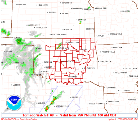
If I were storm chasing today I'd set up between Lawton, OK and the Red River for initiation and follow storms east.
Denton, TX wouldn't be a bad place to start either.
Texas Spring 2023
Moderator: S2k Moderators
Forum rules

The posts in this forum are NOT official forecast and should not be used as such. They are just the opinion of the poster and may or may not be backed by sound meteorological data. They are NOT endorsed by any professional institution or STORM2K.
Re: Texas Spring 2023
2 likes
-
Iceresistance

- Category 5

- Posts: 9581
- Age: 22
- Joined: Sat Oct 10, 2020 9:45 am
- Location: Tecumseh, OK/Norman, OK
Re: Texas Spring 2023
It only got down to the upper 50s, DP is 55°F
0 likes
Bill 2015 & Beta 2020
Winter 2020-2021
All observations are in Tecumseh, OK unless otherwise noted.
Winter posts are focused mainly for Oklahoma & Texas.
Take any of my forecasts with a grain of salt, refer to the NWS, SPC, and NHC for official information
Never say Never with weather! Because ANYTHING is possible!
Winter 2020-2021
All observations are in Tecumseh, OK unless otherwise noted.
Winter posts are focused mainly for Oklahoma & Texas.
Take any of my forecasts with a grain of salt, refer to the NWS, SPC, and NHC for official information
Never say Never with weather! Because ANYTHING is possible!
-
Iceresistance
- Category 5
- Posts: 9581
- Age: 22
- Joined: Sat Oct 10, 2020 9:45 am
- Location: Tecumseh, OK/Norman, OK
Re: Texas Spring 2023
Lightning coming into Fort Worth right now.
0 likes
Bill 2015 & Beta 2020
Winter 2020-2021
All observations are in Tecumseh, OK unless otherwise noted.
Winter posts are focused mainly for Oklahoma & Texas.
Take any of my forecasts with a grain of salt, refer to the NWS, SPC, and NHC for official information
Never say Never with weather! Because ANYTHING is possible!
Winter 2020-2021
All observations are in Tecumseh, OK unless otherwise noted.
Winter posts are focused mainly for Oklahoma & Texas.
Take any of my forecasts with a grain of salt, refer to the NWS, SPC, and NHC for official information
Never say Never with weather! Because ANYTHING is possible!

-
cheezyWXguy

- Category 5
- Posts: 6282
- Joined: Mon Feb 13, 2006 12:29 am
- Location: Dallas, TX
Re: Texas Spring 2023
12z hrrr goes haywire with the stp over dfw this evening, doesn’t mean much in the grand scheme of things though. More important is that the spc bumped up tor probs to 10% from just east of Dallas into east Texas. I swear that region can’t catch a break
1 likes
-
txtwister78

- Category 5
- Posts: 2176
- Joined: Wed Jan 30, 2019 12:56 pm
- Location: San Antonio
Re: Texas Spring 2023
Yup definitely would be a wild intro to "Spring" if we can get that to verify for parts of South-Central Texas. While models have definitely cutback on the overall coverage/amounts over the last few days, they have centered on this particular region as of late giving a bit more confidence to the potential of this actually verifying for some (just NW of SA metro where higher elevation exists into southern HC/Edwards Plateau region).
If I'm not mistaken, I don't think we've ever experienced measurable snowfall that far south into TX this late into March? I've seen a few reports from local Mets mentioning the first week of March for the HC/Austin Area, but this would definitely be something to talk about for a long time should it occur.
2 likes
-
txtwister78
- Category 5
- Posts: 2176
- Joined: Wed Jan 30, 2019 12:56 pm
- Location: San Antonio
Re: Texas Spring 2023


Last edited by txtwister78 on Thu Mar 16, 2023 10:28 am, edited 1 time in total.
0 likes
Re: Texas Spring 2023
txtwister78 wrote:
If I'm not mistaken, I don't think we've ever experienced measurable snowfall that far south into TX this late into March? I've seen a few reports from local Mets mentioning the first week of March for the HC/Austin Area, but this would definitely be something to talk about for a long time should it occur.
I don't trust some of the official "Trace" mentions of snow in the climate record for Austin, but I see 0.3" on March 18, 1934, and a 0.1" on March 27, 1930.
Both are before my time here so I can't confirm.
1 likes
-
Iceresistance
- Category 5
- Posts: 9581
- Age: 22
- Joined: Sat Oct 10, 2020 9:45 am
- Location: Tecumseh, OK/Norman, OK
Re: Texas Spring 2023
Uh oh

https://s2.gifyu.com/images/mcd0290.gif
https://s2.gifyu.com/images/mcd0290.gif
Mesoscale Discussion 0290
NWS Storm Prediction Center Norman OK
1027 AM CDT Thu Mar 16 2023
Areas affected...portions of southwest into central OK
Concerning...Severe potential...Watch possible
Valid 161527Z - 161730Z
Probability of Watch Issuance...40 percent
SUMMARY...Thunderstorm coverage is expected to increase from
southwest into central OK over the next 1-2 hours. Hail will be the
main hazard with initial thunderstorms into early afternoon. A watch
may be needed in the next hour or so.
DISCUSSION...Areas of deeper convective cells are developing within
broader area of showers across western OK late this morning ahead of
a fast, southeastward-advancing surface cold front. An elevated
mixed-layer noted in 12z regional RAOBs may result in initial
thunderstorm activity remaining elevated. Also, as the cold front
quickly progresses southeast, initial storms late this morning into
midday may quickly become undercut by the front. Forecast RAP/NAM
soundings indicate some erosion of steeper midlevel lapse rates is
occurring as early showers move across central OK. However, midlevel
lapse rates, coupled with favorable shear profiles and modest
instability, should support a few organized cells/clusters capable
of producing hail.
There is some uncertainty in intensity of initial storms in a narrow
corridor (generally along the I-44/I-40 corridor) in central OK the
next few hours. However, a greater severe threat, including
potential for a few tornadoes, is expected just south and east
across south-central/southeast OK and north TX, where more favorable
surface-based convection is expected by mid-afternoon. While the
tornado threat may be lower across the narrow corridor of mainly
large hail potential across central OK, a watch may be needed in the
next hour or so.
0 likes
Bill 2015 & Beta 2020
Winter 2020-2021
All observations are in Tecumseh, OK unless otherwise noted.
Winter posts are focused mainly for Oklahoma & Texas.
Take any of my forecasts with a grain of salt, refer to the NWS, SPC, and NHC for official information
Never say Never with weather! Because ANYTHING is possible!
Winter 2020-2021
All observations are in Tecumseh, OK unless otherwise noted.
Winter posts are focused mainly for Oklahoma & Texas.
Take any of my forecasts with a grain of salt, refer to the NWS, SPC, and NHC for official information
Never say Never with weather! Because ANYTHING is possible!
-
bubba hotep

- S2K Supporter

- Posts: 6014
- Joined: Wed Dec 28, 2016 1:00 am
- Location: Collin County Texas
Re: Texas Spring 2023
There appears to be a very brief window for a significant tornado across DFW if storms can fire along the dryline and mature before the cold front overtakes things.
0 likes
Winter time post are almost exclusively focused on the DFW area.
-
Iceresistance
- Category 5
- Posts: 9581
- Age: 22
- Joined: Sat Oct 10, 2020 9:45 am
- Location: Tecumseh, OK/Norman, OK
Re: Texas Spring 2023
Crap, the Bulk Shear is stronger and SCP is higher in Northern Texas than expected.
2 likes
Bill 2015 & Beta 2020
Winter 2020-2021
All observations are in Tecumseh, OK unless otherwise noted.
Winter posts are focused mainly for Oklahoma & Texas.
Take any of my forecasts with a grain of salt, refer to the NWS, SPC, and NHC for official information
Never say Never with weather! Because ANYTHING is possible!
Winter 2020-2021
All observations are in Tecumseh, OK unless otherwise noted.
Winter posts are focused mainly for Oklahoma & Texas.
Take any of my forecasts with a grain of salt, refer to the NWS, SPC, and NHC for official information
Never say Never with weather! Because ANYTHING is possible!
-
somethingfunny

- ChatStaff

- Posts: 3926
- Age: 37
- Joined: Thu May 31, 2007 10:30 pm
- Location: McKinney, Texas
Re: Texas Spring 2023
This morning crapvection has us down to 62 degrees in McKinney at 11:30 AM. It doesn't feel like a pending severe weather outbreak...
0 likes
I am not a meteorologist, and any posts made by me are not official forecasts or to be interpreted as being intelligent. These posts are just my opinions and are probably silly opinions.
-
Iceresistance
- Category 5
- Posts: 9581
- Age: 22
- Joined: Sat Oct 10, 2020 9:45 am
- Location: Tecumseh, OK/Norman, OK
Re: Texas Spring 2023
Sun is trying to come out at my location
0 likes
Bill 2015 & Beta 2020
Winter 2020-2021
All observations are in Tecumseh, OK unless otherwise noted.
Winter posts are focused mainly for Oklahoma & Texas.
Take any of my forecasts with a grain of salt, refer to the NWS, SPC, and NHC for official information
Never say Never with weather! Because ANYTHING is possible!
Winter 2020-2021
All observations are in Tecumseh, OK unless otherwise noted.
Winter posts are focused mainly for Oklahoma & Texas.
Take any of my forecasts with a grain of salt, refer to the NWS, SPC, and NHC for official information
Never say Never with weather! Because ANYTHING is possible!
-
Iceresistance
- Category 5
- Posts: 9581
- Age: 22
- Joined: Sat Oct 10, 2020 9:45 am
- Location: Tecumseh, OK/Norman, OK
Re: Texas Spring 2023
Watching the storms, they're in Linear Mode right now along I-44
0 likes
Bill 2015 & Beta 2020
Winter 2020-2021
All observations are in Tecumseh, OK unless otherwise noted.
Winter posts are focused mainly for Oklahoma & Texas.
Take any of my forecasts with a grain of salt, refer to the NWS, SPC, and NHC for official information
Never say Never with weather! Because ANYTHING is possible!
Winter 2020-2021
All observations are in Tecumseh, OK unless otherwise noted.
Winter posts are focused mainly for Oklahoma & Texas.
Take any of my forecasts with a grain of salt, refer to the NWS, SPC, and NHC for official information
Never say Never with weather! Because ANYTHING is possible!
-
Iceresistance
- Category 5
- Posts: 9581
- Age: 22
- Joined: Sat Oct 10, 2020 9:45 am
- Location: Tecumseh, OK/Norman, OK
Re: Texas Spring 2023

0 likes
Bill 2015 & Beta 2020
Winter 2020-2021
All observations are in Tecumseh, OK unless otherwise noted.
Winter posts are focused mainly for Oklahoma & Texas.
Take any of my forecasts with a grain of salt, refer to the NWS, SPC, and NHC for official information
Never say Never with weather! Because ANYTHING is possible!
Winter 2020-2021
All observations are in Tecumseh, OK unless otherwise noted.
Winter posts are focused mainly for Oklahoma & Texas.
Take any of my forecasts with a grain of salt, refer to the NWS, SPC, and NHC for official information
Never say Never with weather! Because ANYTHING is possible!
-
bubba hotep
- S2K Supporter
- Posts: 6014
- Joined: Wed Dec 28, 2016 1:00 am
- Location: Collin County Texas
Re: Texas Spring 2023

Mesoscale Discussion 0291
NWS Storm Prediction Center Norman OK
1252 PM CDT Thu Mar 16 2023
Areas affected...portions of the Red River Valley in south-central
OK and north TX
Concerning...Severe potential...Watch likely
Valid 161752Z - 161845Z
Probability of Watch Issuance...80 percent
SUMMARY...The threat for damaging wind gusts, large hail, and a few
tornadoes is increasing. A WW will likely be issued in the next
couple of hours.
DISCUSSION...As a mid-level wave overspreads the region, ongoing
convection initiation (currently located along the I-44 corridor in
southwestern/central OK) is expected to continue southwestward into
portions of north TX. This will occur along a surging cold front
and, possibly, ahead of the cold front near a triple point along an
eastward surging dryline. All severe hazards will be possible with
these storms, including a few tornadoes (perhaps one or two strong),
large hail, and damaging wind gusts. A WW will likely be needed in
the next 1-2 hours.
For storms initiating along the cold front, the nature of associated
hazards will depend on a delicate balance between expected storm
motion and cold front motion. Given a southward-surging cold front,
sustained surface-based supercells appear unlikely. However,
forecast soundings suggest early/mature supercell bearings around
240/260 degrees, respectively. The cold front also turns sharply
toward the northeast through western OK (roughly from LTS/OJA/WDG).
These factors may support more sustained surface-based inflow with
any supercells forming along that portion of the cold front,
suggesting a greater threat for tornadoes and damaging wind gusts.
Regardless of the surface-based nature of the inflow, any supercell
forming near the front will pose a threat for large hail given
substantial low-level moisture, steep mid-level lapse rates, and
large bulk shear.
A conditional threat for a few tornadoes, perhaps one or two strong,
and large, damaging hail could materialize if any pre-frontal
discrete supercells form. The greatest chance for this to occur
should reside along the Red River Valley, downstream of an
anticipated triple point around 19-20z near CDS. Some CAM guidance
suggests successful convection initiation in this area. Any storms
forming here would move eastward into an environment supportive of
strong tornadoes and very large hail. Bubbling Cu are currently
noted in northwest TX ahead of the cold front. Should successful
convection initiation occur here, a local corridor of greater
severe-weather potential may materialize this afternoon along the
Red River Valley.
..Flournoy/Kerr.. 03/16/2023
...Please see http://www.spc.noaa.gov for graphic product...
0 likes
Winter time post are almost exclusively focused on the DFW area.
-
Iceresistance
- Category 5
- Posts: 9581
- Age: 22
- Joined: Sat Oct 10, 2020 9:45 am
- Location: Tecumseh, OK/Norman, OK
Re: Texas Spring 2023
Golf Ball Sized hail reported in Frederick.
0 likes
Bill 2015 & Beta 2020
Winter 2020-2021
All observations are in Tecumseh, OK unless otherwise noted.
Winter posts are focused mainly for Oklahoma & Texas.
Take any of my forecasts with a grain of salt, refer to the NWS, SPC, and NHC for official information
Never say Never with weather! Because ANYTHING is possible!
Winter 2020-2021
All observations are in Tecumseh, OK unless otherwise noted.
Winter posts are focused mainly for Oklahoma & Texas.
Take any of my forecasts with a grain of salt, refer to the NWS, SPC, and NHC for official information
Never say Never with weather! Because ANYTHING is possible!


-
bubba hotep
- S2K Supporter
- Posts: 6014
- Joined: Wed Dec 28, 2016 1:00 am
- Location: Collin County Texas
-
Iceresistance
- Category 5
- Posts: 9581
- Age: 22
- Joined: Sat Oct 10, 2020 9:45 am
- Location: Tecumseh, OK/Norman, OK
Re: Texas Spring 2023
Cold Front just passed me, temperatures nosediving.
0 likes
Bill 2015 & Beta 2020
Winter 2020-2021
All observations are in Tecumseh, OK unless otherwise noted.
Winter posts are focused mainly for Oklahoma & Texas.
Take any of my forecasts with a grain of salt, refer to the NWS, SPC, and NHC for official information
Never say Never with weather! Because ANYTHING is possible!
Winter 2020-2021
All observations are in Tecumseh, OK unless otherwise noted.
Winter posts are focused mainly for Oklahoma & Texas.
Take any of my forecasts with a grain of salt, refer to the NWS, SPC, and NHC for official information
Never say Never with weather! Because ANYTHING is possible!
Return to “USA & Caribbean Weather”
Who is online
Users browsing this forum: Bing [Bot], mmmmsnouts and 63 guests