ENSO Updates (2007 thru 2023)

This is the general tropical discussion area. Anyone can take their shot at predicting a storms path.

Moderator: S2k Moderators

Forum rules

The posts in this forum are NOT official forecasts and should not be used as such. They are just the opinion of the poster and may or may not be backed by sound meteorological data. They are NOT endorsed by any professional institution or STORM2K. For official information, please refer to products from the National Hurricane Center and National Weather Service.

Help Support Storm2K
Message
Author
User avatar
WalterWhite
Category 1
Category 1
Posts: 342
Joined: Fri Mar 17, 2023 5:53 pm

Re: ENSO Updates

#13061 Postby WalterWhite » Sun Apr 09, 2023 5:29 am

JetFuel_SE wrote:
Astromanía wrote:Systems on ATL basin before August are mostly weak and short lived even in La Niña years, if we are going to end up with a moderate to strong el Niño by peak season I don't see the ATL really competing in activity to EPAC. In 2016 and 2018 seasons both basins almost end up hyperactive but I don't think the pattern is the same in this case, we need to see what actually happens, I just don't expect great activity for ATL this year but that's just me

The Atlantic had absolutely no right to be active in 2018.
A clear -AMO signature combined with a looming El Niño isn't exactly a good recipe for Atlantic activity.


I believe the official AMO index used by NOAA was positive during ASO of 2018.
0 likes   

User avatar
cycloneye
Admin
Admin
Posts: 145304
Age: 68
Joined: Thu Oct 10, 2002 10:54 am
Location: San Juan, Puerto Rico

Re: ENSO Updates

#13062 Postby cycloneye » Sun Apr 09, 2023 9:51 am

1 likes   
Visit the Caribbean-Central America Weather Thread where you can find at first post web cams,radars
and observations from Caribbean basin members Click Here

LarryWx
S2K Supporter
S2K Supporter
Posts: 6305
Joined: Sun Sep 07, 2003 2:04 pm
Location: GA

Re: ENSO Updates

#13063 Postby LarryWx » Sun Apr 09, 2023 1:16 pm

Kingarabian wrote: Generally, if there's going to be a super El Nino there has to be some type of +ENSO conditions in the prior year, especially during OND. Plus, per Climo super El Nino's typically happen every 15-20 years or so.


Here's the way I'm looking at the ENSO climo from year to year based on looking at the combination of the CPC table since 1950 and Eric Webb's tables prior to 1950 that go back to 1850:

- The greatest rise since 1850 in the 3 month average from one fall/winter to the next is 3.1, which was from the 1971-2 moderate Niña to the 1972-3 super Nino.

- Next largest rises were 2.9 (1996-7 to 1997-8), 2.8 (1964-5 to 1965-6), 2.6 (1975-6 to 1976-7 and 1917-8 to 1918-9), 2.5 (1924-5 to 1925-6), 2.4 (2008-9 to 2009-10 and 1981-2 to 1982-3), 2.3 (1910-1 to 1911-2), and 2.2 (1956-7 to 1957-8 and 1898-9 to 1899-1900).

- So, there have been 11 rises greater than 2.0 since 1850. The 2022-3 ENSO dipped to a low of -1.0. So, in order for 2023-4 to reach super Nino strength (+2.0+), it would take THE largest rise since the late 1800s (the 3.1 rise from 1971-2 to 1972-3) to accomplish that.

- Based on this, alone, the chances of a super Nino peak in 2023-4 are low.

- It would take a rise of 2.5 to 2.9 to get a strong Nino peak in 2023-4. There have been five rises of 2.5 to 2.9 since 1850. That, alone, suggests a significantly higher chance for a strong Nino peak than a super Nino peak in 2023-4.

- Fwiw after adjusting for an implied warm bias, the April 1st Euro ensemble is suggesting that the highest chance is for strong over high end moderate or super.

- Thus, as of now, I'm leaning toward a strong Nino three month averaged peak (+1.5 to +1.9) as most likely for 2023-24 with high end moderate (+1.3 to +1.4) as second most likely and super (+2.0+) as third most likely.
5 likes   
Personal Forecast Disclaimer:
The posts in this forum are NOT official forecasts and should not be used as such. They are just the opinion of the poster and may or may not be backed by sound meteorological data. They are NOT endorsed by any professional institution or storm2k.org. For official information, please refer to the NHC and NWS products.

User avatar
Blown Away
S2K Supporter
S2K Supporter
Posts: 10145
Joined: Wed May 26, 2004 6:17 am

Re: ENSO Updates

#13064 Postby Blown Away » Mon Apr 10, 2023 7:05 am

Landy wrote:University of Arizona released their April forecast yesterday, quite bullish considering the overall consensus I've seen. Predicting 19/9/5 with next forecast in early June 2023. Their sample size is pretty small, but their April forecast last year was the closest in verification, so it'll be interesting to see how this verifies.

https://media.discordapp.net/attachments/877402829797621770/1094283153683791932/Screenshot_2023-04-08-11-29-04-76_e2d5b3f32b79de1d45acd1fad96fbb0f.jpg

Link to the report: https://has.arizona.edu/sites/default/files/april_2023_tropical_cyclone_forecast.pdf


Shear usually trumps SST's and to project those high storm #'s during a likely El Nino year is not typical. Although last season IMO behaved like an Atlantic El Nino with reduced #'s, shear, and EPAC going crazy. JMHO

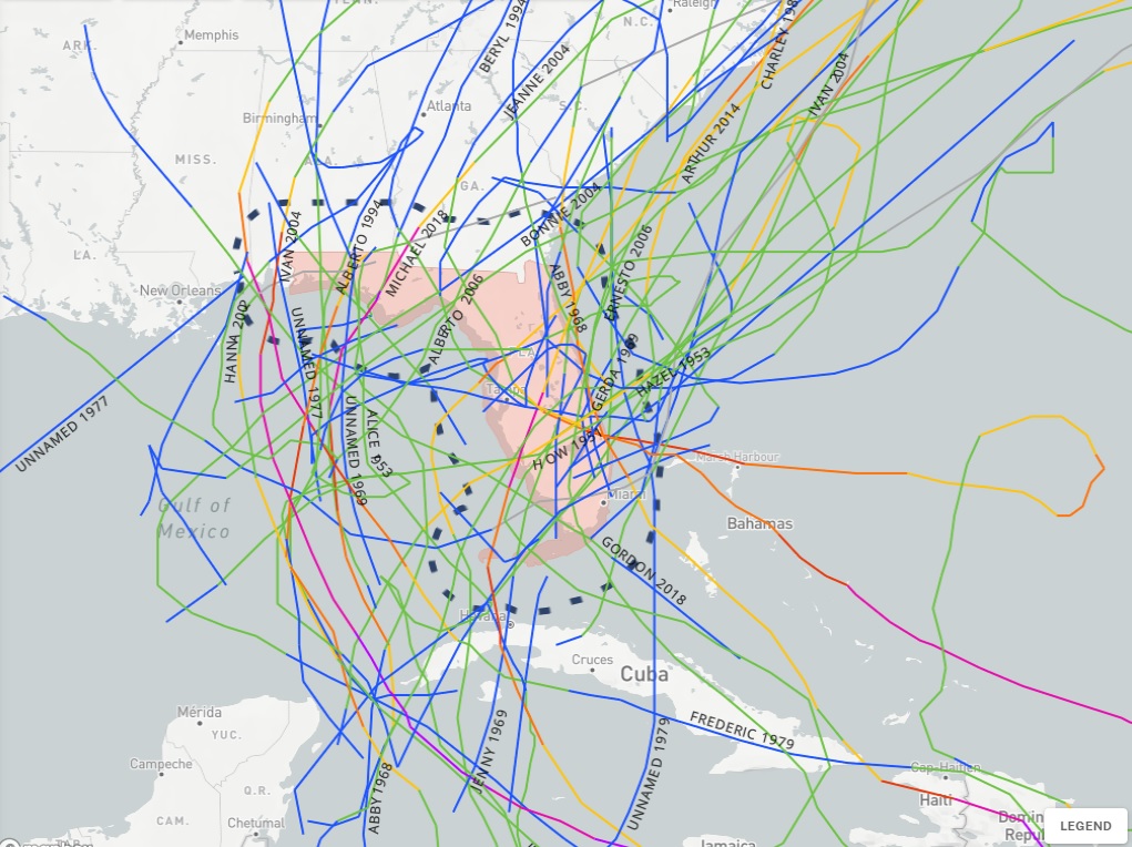
Here in southern Fl if the current dry conditions continue into summer and possible El Nino developing @September it increases the chances of a TS/Hurricane into FL. JMHO

Image
All TS/Hurricanes into FL in the first year of a "Weak" or "Moderate" El Nino since 1950.
0 likes   
Hurricane Eye Experience: David 79, Irene 99, Frances 04, Jeanne 04, Wilma 05... EYE COMING MY WAY IN 2024…
Hurricane Brush Experience: Andrew 92, Erin 95, Floyd 99, Matthew 16, Irma 17, Ian 22, Nicole 22…

User avatar
cycloneye
Admin
Admin
Posts: 145304
Age: 68
Joined: Thu Oct 10, 2002 10:54 am
Location: San Juan, Puerto Rico

Re: ENSO Updates

#13065 Postby cycloneye » Mon Apr 10, 2023 7:28 am

1 likes   
Visit the Caribbean-Central America Weather Thread where you can find at first post web cams,radars
and observations from Caribbean basin members Click Here

User avatar
Category5Kaiju
Category 5
Category 5
Posts: 4097
Joined: Thu Dec 24, 2020 12:45 pm
Location: Seattle

Re: ENSO Updates

#13066 Postby Category5Kaiju » Mon Apr 10, 2023 7:55 am

It's something that I noticed very recently, but I wonder how the Atlantic was able to go 12/8/3, 14/7/3, and 12/7/3 in the El Nino years 1951, 1953, and 1958 respectively. For some reason, the Atlantic has done surprisingly well in multiple El Nino years in the 1950s, but I'm not very sure why or how.
1 likes   
Unless explicitly stated, all info in my posts is based on my own opinions and observations. Tropical storms and hurricanes can be extremely dangerous. Do not think you can beat Mother Nature. Refer to an accredited weather research agency or meteorologist if you need to make serious decisions regarding an approaching storm.

User avatar
cycloneye
Admin
Admin
Posts: 145304
Age: 68
Joined: Thu Oct 10, 2002 10:54 am
Location: San Juan, Puerto Rico

Re: ENSO Updates: CPC Weekly update: Niño 3.4 at 0.0C / Niño 1+2 up to +2.7C

#13067 Postby cycloneye » Mon Apr 10, 2023 8:16 am

CPC weekly update remains at 0.0C at Niño 3.4 but is very warm at Niño 1+2 at 2.7C.

Image

Image

https://www.cpc.ncep.noaa.gov/products/ ... ts-web.pdf
2 likes   
Visit the Caribbean-Central America Weather Thread where you can find at first post web cams,radars
and observations from Caribbean basin members Click Here

dexterlabio
Category 5
Category 5
Posts: 3468
Joined: Sat Oct 24, 2009 11:50 pm

Re: ENSO Updates: CPC Weekly update: Niño 3.4 at 0.0C / Niño 1+2 up to +2.7C

#13068 Postby dexterlabio » Mon Apr 10, 2023 8:25 am

Has anyone considered 1972 as analog to 2023? ENSO-wise I think that year fits because it also came out of a La Niña, and it was also a -PDO year.
0 likes   
Personal Forecast Disclaimer:
The posts in this forum are NOT official forecast and should not be used as such. They are just the opinion of the poster and may or may not be backed by sound meteorological data. They are NOT endorsed by any professional institution or storm2k.org. For official information, please refer to the NHC and NWS products.

User avatar
Iceresistance
Category 5
Category 5
Posts: 9288
Age: 21
Joined: Sat Oct 10, 2020 9:45 am
Location: Tecumseh, OK/Norman, OK

Re: ENSO Updates: CPC Weekly update: Niño 3.4 at 0.0C / Niño 1+2 up to +2.7C

#13069 Postby Iceresistance » Mon Apr 10, 2023 8:37 am

cycloneye wrote:CPC weekly update remains at 0.0C at Niño 3.4 but is very warm at Niño 1+2 at 2.7C.

https://i.imgur.com/tpHPKtV.jpg

https://i.imgur.com/UHYQdw2.jpg

https://www.cpc.ncep.noaa.gov/products/ ... ts-web.pdf

The graph of Nino 3.4 is making me think that Nino 3.4 is at +.05°C :lol:
0 likes   
Bill 2015 & Beta 2020

Winter 2020-2021 :cold:

All observations are in Tecumseh, OK unless otherwise noted.

Winter posts are focused mainly for Oklahoma & Texas.

Take any of my forecasts with a grain of salt, refer to the NWS, SPC, and NHC for official information

Never say Never with weather! Because ANYTHING is possible!

User avatar
cycloneye
Admin
Admin
Posts: 145304
Age: 68
Joined: Thu Oct 10, 2002 10:54 am
Location: San Juan, Puerto Rico

Re: ENSO Updates: CPC Weekly update: Niño 3.4 at 0.0C / Niño 1+2 up to +2.7C

#13070 Postby cycloneye » Mon Apr 10, 2023 8:37 am

dexterlabio wrote:Has anyone considered 1972 as analog to 2023? ENSO-wise I think that year fits because it also came out of a La Niña, and it was also a -PDO year.


1972=7/3/0

Image
0 likes   
Visit the Caribbean-Central America Weather Thread where you can find at first post web cams,radars
and observations from Caribbean basin members Click Here

LarryWx
S2K Supporter
S2K Supporter
Posts: 6305
Joined: Sun Sep 07, 2003 2:04 pm
Location: GA

Re: ENSO Updates: CPC Weekly update: Niño 3.4 at 0.0C / Niño 1+2 up to +2.7C

#13071 Postby LarryWx » Mon Apr 10, 2023 11:08 am

cycloneye wrote:CPC weekly update remains at 0.0C at Niño 3.4 but is very warm at Niño 1+2 at 2.7C.

https://www.cpc.ncep.noaa.gov/products/ ... ts-web.pdf


For an ONCOMING El Niño in the highly volatile Nino 1+2, the current +2.7 is way warmer than any other one in April since 1982. The old record warmth in 1+2 during April in an oncoming Nino back to 1982 was +1.3 set in 2015 and in 1997.

April 2015 peaked at +1.3
April 2009 peaked at +0.6
April 2002 peaked at +1.1
April 1997 peaked at +1.3
April 1982 peaked at -1.0 (yes, it was still negative)

https://www.cpc.ncep.noaa.gov/data/indi ... st9120.for
Last edited by LarryWx on Mon Apr 10, 2023 11:18 am, edited 1 time in total.
3 likes   
Personal Forecast Disclaimer:
The posts in this forum are NOT official forecasts and should not be used as such. They are just the opinion of the poster and may or may not be backed by sound meteorological data. They are NOT endorsed by any professional institution or storm2k.org. For official information, please refer to the NHC and NWS products.

User avatar
cycloneye
Admin
Admin
Posts: 145304
Age: 68
Joined: Thu Oct 10, 2002 10:54 am
Location: San Juan, Puerto Rico

Re: ENSO Updates: CPC Weekly update: Niño 3.4 at 0.0C / Niño 1+2 up to +2.7C

#13072 Postby cycloneye » Mon Apr 10, 2023 11:10 am

LarryWx wrote:
cycloneye wrote:CPC weekly update remains at 0.0C at Niño 3.4 but is very warm at Niño 1+2 at 2.7C.

https://www.cpc.ncep.noaa.gov/products/ ... ts-web.pdf


For an ONCOMING El Niño in the highly volatile Nino 1+2, the current +2.7 is way warmer than any other one in April since 1982. The old record warmth in an oncoming was +1.3 set in 2015 and in 1997.

April 2015 peaked at +1.3
April 2009 peaked at +0.6
April 2002 peaked at +1.1
April 1997 peaked at +1.3
April 1982 peaked at -1.0 (yes, it was still negative)


Very interesting Larry.
1 likes   
Visit the Caribbean-Central America Weather Thread where you can find at first post web cams,radars
and observations from Caribbean basin members Click Here

User avatar
Yellow Evan
Professional-Met
Professional-Met
Posts: 16143
Age: 27
Joined: Fri Jul 15, 2011 12:48 pm
Location: Henderson, Nevada/Honolulu, HI
Contact:

Re: ENSO Updates

#13073 Postby Yellow Evan » Mon Apr 10, 2023 11:22 am

Category5Kaiju wrote:It's something that I noticed very recently, but I wonder how the Atlantic was able to go 12/8/3, 14/7/3, and 12/7/3 in the El Nino years 1951, 1953, and 1958 respectively. For some reason, the Atlantic has done surprisingly well in multiple El Nino years in the 1950s, but I'm not very sure why or how.


Africa.
1 likes   

User avatar
Kingarabian
S2K Supporter
S2K Supporter
Posts: 15980
Joined: Sat Aug 08, 2009 3:06 am
Location: Honolulu, Hawaii

Re: ENSO Updates: CPC Weekly update: Niño 3.4 at 0.0C / Niño 1+2 up to +2.7C

#13074 Postby Kingarabian » Mon Apr 10, 2023 11:25 pm

GFS has a significant WWB at 160E. This would be enough for El Nino. Although It's not at the dateline its good enough considering the status quo, and that another WWB in the CPAC will eventually follow during mid-late May.
Image

EPS is much weaker though and quickly brings back the trades by mid April.
2 likes   
RIP Kobe Bryant

User avatar
cycloneye
Admin
Admin
Posts: 145304
Age: 68
Joined: Thu Oct 10, 2002 10:54 am
Location: San Juan, Puerto Rico

Re: ENSO Updates: Bom update= El Niño Watch continues

#13075 Postby cycloneye » Tue Apr 11, 2023 9:03 am

3 likes   
Visit the Caribbean-Central America Weather Thread where you can find at first post web cams,radars
and observations from Caribbean basin members Click Here

User avatar
cycloneye
Admin
Admin
Posts: 145304
Age: 68
Joined: Thu Oct 10, 2002 10:54 am
Location: San Juan, Puerto Rico

Re: ENSO Updates: BoM update= El Niño Watch continues

#13076 Postby cycloneye » Tue Apr 11, 2023 10:20 am

1 likes   
Visit the Caribbean-Central America Weather Thread where you can find at first post web cams,radars
and observations from Caribbean basin members Click Here

LarryWx
S2K Supporter
S2K Supporter
Posts: 6305
Joined: Sun Sep 07, 2003 2:04 pm
Location: GA

Re: ENSO Updates: Bom update= El Niño Watch continues

#13077 Postby LarryWx » Tue Apr 11, 2023 10:22 am


Thanks, Luis. I just noticed that the Aussies are more conservative with their threshold for El Niño as they require +0.8 C instead of just +0.5 C:

"Persistent NINO3.4 values above +0.8 °C typically indicate El Niño, while values below −0.8 °C typically indicate La Niña."
1 likes   
Personal Forecast Disclaimer:
The posts in this forum are NOT official forecasts and should not be used as such. They are just the opinion of the poster and may or may not be backed by sound meteorological data. They are NOT endorsed by any professional institution or storm2k.org. For official information, please refer to the NHC and NWS products.

User avatar
Iceresistance
Category 5
Category 5
Posts: 9288
Age: 21
Joined: Sat Oct 10, 2020 9:45 am
Location: Tecumseh, OK/Norman, OK

Re: ENSO Updates: BoM update= El Niño Watch continues

#13078 Postby Iceresistance » Tue Apr 11, 2023 10:31 am


I was just about to post this, goodness, that is the definition of a Super El Niño
0 likes   
Bill 2015 & Beta 2020

Winter 2020-2021 :cold:

All observations are in Tecumseh, OK unless otherwise noted.

Winter posts are focused mainly for Oklahoma & Texas.

Take any of my forecasts with a grain of salt, refer to the NWS, SPC, and NHC for official information

Never say Never with weather! Because ANYTHING is possible!

User avatar
Iceresistance
Category 5
Category 5
Posts: 9288
Age: 21
Joined: Sat Oct 10, 2020 9:45 am
Location: Tecumseh, OK/Norman, OK

Re: ENSO Updates: BoM update= El Niño Watch continues

#13079 Postby Iceresistance » Tue Apr 11, 2023 10:36 am

Warm Subsurface pool coming up towards the surface.

Image
https://s2.gifyu.com/images/Subsurface-SST.gif
3 likes   
Bill 2015 & Beta 2020

Winter 2020-2021 :cold:

All observations are in Tecumseh, OK unless otherwise noted.

Winter posts are focused mainly for Oklahoma & Texas.

Take any of my forecasts with a grain of salt, refer to the NWS, SPC, and NHC for official information

Never say Never with weather! Because ANYTHING is possible!

dexterlabio
Category 5
Category 5
Posts: 3468
Joined: Sat Oct 24, 2009 11:50 pm

Re: ENSO Updates: BoM update= El Niño Watch continues

#13080 Postby dexterlabio » Tue Apr 11, 2023 10:52 am

Interesting to see what will happen when the subsurface warm pool reaches the already very warm surface in the east.
0 likes   
Personal Forecast Disclaimer:
The posts in this forum are NOT official forecast and should not be used as such. They are just the opinion of the poster and may or may not be backed by sound meteorological data. They are NOT endorsed by any professional institution or storm2k.org. For official information, please refer to the NHC and NWS products.


Return to “Talkin' Tropics”

Who is online

Users browsing this forum: IsabelaWeather, USTropics and 44 guests