Bedout just recorded 111 knots ( 10 minutes sustained wind)
safe to say its a confirmed cat 5 ( aussie)
SIO: ILSA - Post-Tropical
Moderator: S2k Moderators
-
mrbagyo

- Category 5

- Posts: 3963
- Age: 33
- Joined: Thu Apr 12, 2012 9:18 am
- Location: 14.13N 120.98E
- Contact:
Re: SIO: ILSA - Severe Tropical Cyclone
1 likes
The posts in this forum are NOT official forecast and should not be used as such. They are just the opinion of the poster and may or may not be backed by sound meteorological data. They are NOT endorsed by any professional institution or storm2k.org. For official information, please refer to RSMC, NHC and NWS products.

Re: SIO: ILSA - Severe Tropical Cyclone
Pressure at the Bedout Island station is cratering right now. Like, right this moment. Wild how we can access this data in virtually real time so easily now. It's a nice reminder of what the internet can do.
1 likes
-
cycloneye

- Admin

- Posts: 149275
- Age: 69
- Joined: Thu Oct 10, 2002 10:54 am
- Location: San Juan, Puerto Rico
Re: SIO: ILSA - Severe Tropical Cyclone
1 likes
Visit the Caribbean-Central America Weather Thread where you can find at first post web cams,radars
and observations from Caribbean basin members Click Here
and observations from Caribbean basin members Click Here


Re: SIO: ILSA - Severe Tropical Cyclone
It looks like the Bedout Island station failed immediately after recording a new Australian record for 10-minute wind speed.
https://twitter.com/BOM_WA/status/1646513163763089412
https://twitter.com/BOM_WA/status/1646513163763089412
1 likes
-
Hurricane2022

- Category 5
- Posts: 2016
- Joined: Tue Aug 23, 2022 11:38 pm
- Location: Araçatuba, Brazil
Re: SIO: ILSA - Severe Tropical Cyclone
https://twitter.com/KeviShader/status/1646507546788745217
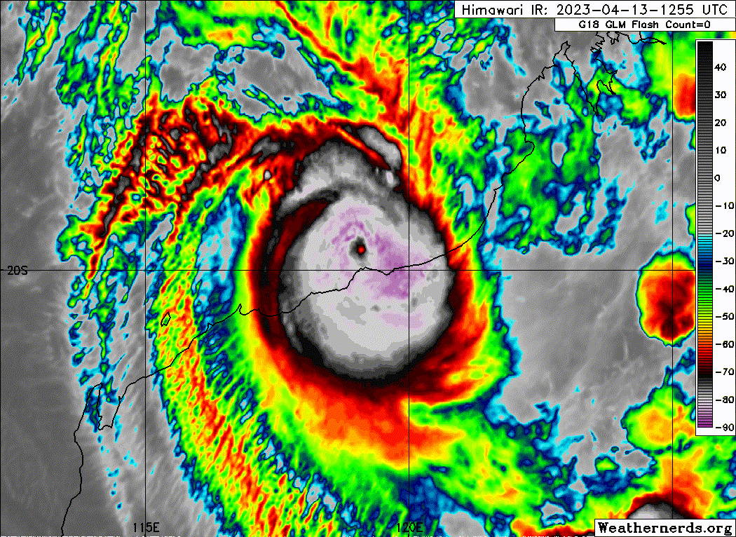
These data are very precious. For now, i'm in agreement with JTWC's estimate for landfall (18S ILSA 230413 1200 19.4S 119.1E SHEM 135 922), but also is a real possibility of Ilsa being a Cat5 TC now.

The peak intensity was probably around 0800 - 0900 UTC, with winds of 150 kt and a minimum pressure of 910 mb (my estimates)
https://twitter.com/zeb199818/status/1646437152048451587
... I look forward to seeing the BoM and JTWC verdict.
These data are very precious. For now, i'm in agreement with JTWC's estimate for landfall (18S ILSA 230413 1200 19.4S 119.1E SHEM 135 922), but also is a real possibility of Ilsa being a Cat5 TC now.
The peak intensity was probably around 0800 - 0900 UTC, with winds of 150 kt and a minimum pressure of 910 mb (my estimates)
https://twitter.com/zeb199818/status/1646437152048451587
... I look forward to seeing the BoM and JTWC verdict.
1 likes
Sorry for the bad English sometimes...!
For reliable and detailed information for any meteorological phenomenon, please consult the National Hurricane Center, Joint Typhoon Warning Center , or your local Meteo Center.
--------
ECCE OMNIA NOVA FACIAM (Ap 21,5).
For reliable and detailed information for any meteorological phenomenon, please consult the National Hurricane Center, Joint Typhoon Warning Center , or your local Meteo Center.
--------
ECCE OMNIA NOVA FACIAM (Ap 21,5).
-
cycloneye
- Admin
- Posts: 149275
- Age: 69
- Joined: Thu Oct 10, 2002 10:54 am
- Location: San Juan, Puerto Rico
Re: SIO: ILSA - Severe Tropical Cyclone
IDW27600
TROPICAL CYCLONE TECHNICAL BULLETIN: AUSTRALIA - WESTERN REGION
Issued by AUSTRALIAN BUREAU OF METEOROLOGY TROPICAL CYCLONE WARNING CENTRE
at: 1241 UTC 13/04/2023
Name: Severe Tropical Cyclone Ilsa
Identifier: 23U
Data At: 1200 UTC
Latitude: 19.4S
Longitude: 119.1E
Location Accuracy: within 10nm (20 km)
Movement Towards: south southeast (155 deg)
Speed of Movement: 8 knots (14 km/h)
Maximum 10-Minute Wind: 115 knots (215 km/h)
Maximum 3-Second Wind Gust: 160 knots (295 km/h)
Central Pressure: 928 hPa
Radius of 34-knot winds NE quadrant: 70 nm (130 km)
Radius of 34-knot winds SE quadrant: 80 nm (150 km)
Radius of 34-knot winds SW quadrant: 50 nm (95 km)
Radius of 34-knot winds NW quadrant: 90 nm (165 km)
Radius of 48-knot winds NE quadrant: 50 nm (95 km)
Radius of 48-knot winds SE quadrant: 50 nm (95 km)
Radius of 48-knot winds SW quadrant: 40 nm (75 km)
Radius of 48-knot winds NW quadrant: 50 nm (95 km)
Radius of 64-knot winds: 30 nm (30 km)
Radius of Maximum Winds: 10 nm (15 km)
Dvorak Intensity Code: T6.5/6.5/D1.5/24HRS STT:D0.5/06HRS
Pressure of outermost isobar: 1004 hPa
Radius of outermost closed isobar: 150 nm (280 km)
FORECAST DATA
Date/Time : Location : Loc. Accuracy: Max Wind : Central Pressure
(UTC) : degrees : nm (km): knots(km/h): hPa
+06: 13/1800: 20.2S 119.9E: 030 (050): 100 (185): 944
+12: 14/0000: 21.1S 121.2E: 040 (070): 075 (140): 967
+18: 14/0600: 21.9S 123.0E: 045 (085): 060 (110): 979
+24: 14/1200: 22.3S 125.2E: 055 (100): 045 (085): 991
+36: 15/0000: 23.0S 130.4E: 070 (130): 035 (065): 998
+48: 15/1200: 22.4S 135.7E: 100 (185): 025 (045): 1004
+60: 16/0000: : : :
+72: 16/1200: : : :
+96: 17/1200: : : :
+120: 18/1200: : : :
REMARKS:
Severe Tropical Cyclone Ilsa, category 5, impacting the West Australian Coast.
There is very good confidence in the position of the system with an eye visible
and within range of Port Hedland weather radar.
Dvorak analysis of 3 hourly average DT of 6.5 based on an eye pattern. 12Z eye
pattern was W surrounding temperature with a DG/CMG eye adjustment, giving a DT
of 6.5. MET/PAT yields 6.5 based on a D+ 24 hour trend. FT/CI=6.5 based on 3
hourly average DT.
Objective guidance, with ADT CI of 5.7 CIMSS and 6.0 NESDIS, AiDT 106 knots,
and Open-AIIR ranging between 110 to 120 knots (1-min).
Intensity set to 115 knots (category 5) based mainly on Dvorak and a very clear
eye pattern. Assisted by observations at Bedout Island with 10-min mean winds
of 117 knots and gusts of 136 knots.
Wind shear remains moderately low over 23U and at 1200 UTC CIMSS upper wind
analysis has approximately 10 to 15 knots of shear. Isla has recently slowed
its rapid development and is expected to remain at a consistent intensity until
land interactions cause weakening. 23U is forecast to weaken once over land,
but remain at least category 2 a significant distance inland.
Ilsa is now moving to the southeast and a coastal crossing is likely near
midnight, between De Grey and Pardoo Roadhouse. In the long-term, Ilsa is
forecast to move over central Australia and begin a transition to a deep,
sub-tropical system as it interacts with the sub-tropical jet.
0 likes
Visit the Caribbean-Central America Weather Thread where you can find at first post web cams,radars
and observations from Caribbean basin members Click Here
and observations from Caribbean basin members Click Here
-
mrbagyo
- Category 5
- Posts: 3963
- Age: 33
- Joined: Thu Apr 12, 2012 9:18 am
- Location: 14.13N 120.98E
- Contact:
Re: SIO: ILSA - Severe Tropical Cyclone

1 likes
The posts in this forum are NOT official forecast and should not be used as such. They are just the opinion of the poster and may or may not be backed by sound meteorological data. They are NOT endorsed by any professional institution or storm2k.org. For official information, please refer to RSMC, NHC and NWS products.
Re: SIO: ILSA - Severe Tropical Cyclone
The next station that will provide live data from near the core is Pardoo (https://weather.agric.wa.gov.au/station/PD). It is currently reporting sustained winds of 43 kt and a pressure of 987 hPa, recording once per minute.
0 likes


-
Hurricane2022
- Category 5
- Posts: 2016
- Joined: Tue Aug 23, 2022 11:38 pm
- Location: Araçatuba, Brazil
Re: SIO: ILSA - Severe Tropical Cyclone
1 likes
Sorry for the bad English sometimes...!
For reliable and detailed information for any meteorological phenomenon, please consult the National Hurricane Center, Joint Typhoon Warning Center , or your local Meteo Center.
--------
ECCE OMNIA NOVA FACIAM (Ap 21,5).
For reliable and detailed information for any meteorological phenomenon, please consult the National Hurricane Center, Joint Typhoon Warning Center , or your local Meteo Center.
--------
ECCE OMNIA NOVA FACIAM (Ap 21,5).
-
Sciencerocks
- Category 5
- Posts: 10181
- Age: 40
- Joined: Thu Jul 06, 2017 1:51 am
-
cycloneye
- Admin
- Posts: 149275
- Age: 69
- Joined: Thu Oct 10, 2002 10:54 am
- Location: San Juan, Puerto Rico
Re: SIO: ILSA - Severe Tropical Cyclone
0 likes
Visit the Caribbean-Central America Weather Thread where you can find at first post web cams,radars
and observations from Caribbean basin members Click Here
and observations from Caribbean basin members Click Here
-
Yellow Evan

- Professional-Met

- Posts: 16231
- Age: 27
- Joined: Fri Jul 15, 2011 12:48 pm
- Location: Henderson, Nevada/Honolulu, HI
- Contact:
Re: SIO: ILSA - Severe Tropical Cyclone
Given the obs and undersampling, highly likely this peaked at Category 5.
4 likes
-
Hurricane2022
- Category 5
- Posts: 2016
- Joined: Tue Aug 23, 2022 11:38 pm
- Location: Araçatuba, Brazil
Re: SIO: ILSA - Severe Tropical Cyclone
looks like we have a Brown Ocean Effect causing Ilsa to fade slower than expected, like the notorius Hurricane Ida'21 in the USA and TC Kelvin'18, in the same region on Australia

https://twitter.com/135knots/status/1646633107582246914
https://twitter.com/135knots/status/1646633107582246914
0 likes
Sorry for the bad English sometimes...!
For reliable and detailed information for any meteorological phenomenon, please consult the National Hurricane Center, Joint Typhoon Warning Center , or your local Meteo Center.
--------
ECCE OMNIA NOVA FACIAM (Ap 21,5).
For reliable and detailed information for any meteorological phenomenon, please consult the National Hurricane Center, Joint Typhoon Warning Center , or your local Meteo Center.
--------
ECCE OMNIA NOVA FACIAM (Ap 21,5).
-
cycloneye
- Admin
- Posts: 149275
- Age: 69
- Joined: Thu Oct 10, 2002 10:54 am
- Location: San Juan, Puerto Rico
Re: SIO: ILSA - Severe Tropical Cyclone
Officially made landfall at 115 kt as cat 5 of Aussies scale.
TROPICAL CYCLONE TECHNICAL BULLETIN: AUSTRALIA - WESTERN REGION
Issued by AUSTRALIAN BUREAU OF METEOROLOGY TROPICAL CYCLONE WARNING CENTRE
at: 1906 UTC 13/04/2023
Name: Severe Tropical Cyclone Ilsa
Identifier: 23U
Data At: 1800 UTC
Latitude: 20.4S
Longitude: 120.1E
Location Accuracy: within 10nm (20 km)
Movement Towards: southeast (137 deg)
Speed of Movement: 14 knots (25 km/h)
Maximum 10-Minute Wind: 95 knots (175 km/h)
Maximum 3-Second Wind Gust: 135 knots (250 km/h)
Central Pressure: 951 hPa
Radius of 34-knot winds NE quadrant: 70 nm (130 km)
Radius of 34-knot winds SE quadrant: 40 nm (75 km)
Radius of 34-knot winds SW quadrant: 40 nm (75 km)
Radius of 34-knot winds NW quadrant: 70 nm (130 km)
Radius of 48-knot winds NE quadrant: 50 nm (95 km)
Radius of 48-knot winds SE quadrant: 30 nm (55 km)
Radius of 48-knot winds SW quadrant: 30 nm (55 km)
Radius of 48-knot winds NW quadrant: 50 nm (95 km)
Radius of 64-knot winds: 30 nm (30 km)
Radius of Maximum Winds: 10 nm (20 km)
Dvorak Intensity Code: n/a
Pressure of outermost isobar: 1006 hPa
Radius of outermost closed isobar: 190 nm (350 km)
FORECAST DATA
Date/Time : Location : Loc. Accuracy: Max Wind : Central Pressure
(UTC) : degrees : nm (km): knots(km/h): hPa
+06: 14/0000: 21.2S 121.4E: 025 (050): 065 (120): 968
+12: 14/0600: 21.9S 123.2E: 040 (070): 050 (095): 983
+18: 14/1200: 22.5S 125.3E: 045 (085): 045 (085): 992
+24: 14/1800: 22.8S 127.8E: 055 (100): 040 (075): 998
+36: 15/0600: 23.0S 133.3E: 065 (120): 035 (065): 1002
+48: 15/1800: : : :
+60: 16/0600: : : :
+72: 16/1800: : : :
+96: 17/1800: : : :
+120: 18/1800: : : :
REMARKS:
Severe Tropical Cyclone Ilsa, category 4, was located just inland from the West
Australian Coast.
Ilsa crossed the coast about 120km east northeast of Port Hedland around
1600UTC with an estimated intensity of 115 knots (category 5). The cyclone is
currently moving towards the southeast and was located on radar about 60km
inland from the coast at 1800UTC. There is good confidence in the cyclone's
position based on Port Hedland weather radar and an eye is visible on satellite
imagery.
Dvorak intensity analysis is no longer valid as the cyclone is over land.
Intensity was estimated using the overland decay model and set at 95 knots
(category 4).
The cyclone is forecast to weaken as it accelerates towards the east southeast
while passing over the Pilbara region Friday morning and the Northern Interior
of Western Australia later on Friday. The primary steering influence is an
upper trough over southern Western Australia.
The cyclone is forecast to lose its tropical cyclone structure early on
Saturday but strong to gale force winds may persist in the northern semicircle
as it transitions to a deep, sub-tropical system over central Australia.
0 likes
Visit the Caribbean-Central America Weather Thread where you can find at first post web cams,radars
and observations from Caribbean basin members Click Here
and observations from Caribbean basin members Click Here
-
cycloneye
- Admin
- Posts: 149275
- Age: 69
- Joined: Thu Oct 10, 2002 10:54 am
- Location: San Juan, Puerto Rico
Re: SIO: ILSA - Severe Tropical Cyclone
TROPICAL CYCLONE ADVICE NUMBER 48
Issued at 9:03 am WST on Friday 14 April 2023
Headline:
Severe Tropical Cyclone Ilsa is impacting inland areas of the eastern Pilbara and is moving towards Telfer
Areas Affected:
Warning Zone
Inland areas of the eastern Pilbara east of Marble Bar and areas over the North Interior, including Kiwirrkurra, Kunawarritji, Parnngurr but not including Marble Bar and Nullagine
Watch Zone
Nil
Cancelled Zone
None.
Details of Severe Tropical Cyclone Ilsa at 8:00 am AWST:
Intensity: Category 3, sustained winds near the centre of 120 kilometres per hour with wind gusts to 165 kilometres per hour.
Location: within 35 kilometres of 21.3 degrees South 121.3 degrees East, estimated to be 105 kilometres west northwest of Telfer and 160 kilometres east of Marble Bar.
Movement: southeast at 28 kilometres per hour.
Severe Tropical Cyclone Ilsa, category 3 is weakening as it moves further inland.
During today Ilsa is expected to continue moving east southeast and maintain tropical cyclone intensity as it tracks past Telfer and further inland across the northern parts of the Interior. Ilsa is then expected to weaken below tropical cyclone strength overnight tonight as it moves into southern parts of the Northern Territory.
Hazards:
The VERY DESTRUCTIVE CORE of Ilsa, with gusts up to 170 km/h is impacting areas near the centre to the west of Telfer. Winds should weaken below VERY DESTRUCTIVE before the core reaches Telfer.
DESTRUCTIVE WINDS with gusts to 155 km/h are occurring over inland areas of the eastern Pilbara between Marble Bar and Telfer. DESTRUCTIVE WINDS are expected to reach Telfer this morning and Punmu at about midday, and move towards Kunawarritji during the afternoon.
DAMAGING WINDS with gusts to 100 km/h are occurring over inland areas of the eastern Pilbara between Marble Bar and Telfer. DAMAGING WINDS are starting to develop at Telfer, are expected to reach Punmu late morning, could reach Parnngurr by this afternoon, and are expected to reach Kunawarritji this afternoon and Kiwirrkurra this evening. At affected locations, DAMAGING WINDS are expected to last 4 to 6 hours.
DAMAGING WINDS from the remnants of Ilsa are possible across southern parts of the Northern Territory on Saturday, please refer to the Severe Weather Warning for more information [http://www.bom.gov.au/products/IDD21037.shtml].
HEAVY to INTENSE RAINFALL is expected along the track of Ilsa. 150 to 200 mm of rainfall is possible during today near where the system tracks, with falls gradually decreasing as it tracks further inland.
Recommended Action:
DFES advises of the following Community Alerts (effective as of 9:00am 14/04/2023):
RED ALERT: For Wallal Downs to De Grey, inland to Kunawarritji including Marble Bar, Nullagine, Telfer, Punmu and Parnngurr need to go to shelter immediately.
YELLOW ALERT: Inland areas east of Kunawarritji, need to take action and get ready to shelter from a cyclone.
ALL CLEAR: People in communities between Broome and Wallal Downs (not including Wallal Downs) and for Whim Creek to De Grey (not including De Grey) extending inland to Marble Bar Road are advised that wind and storm surge dangers have passed but you need to take care to avoid the dangers caused by damage.
0 likes
Visit the Caribbean-Central America Weather Thread where you can find at first post web cams,radars
and observations from Caribbean basin members Click Here
and observations from Caribbean basin members Click Here
Re: SIO: ILSA - Severe Tropical Cyclone
First pictures of the damage to Pardoo Roadhouse are now emerging. Apparently, the owners stayed there during the cyclone and took shelter in an old sea container.

Posted by their Facebook page: https://www.facebook.com/Pardooroadhouseandtavern
Posted by their Facebook page: https://www.facebook.com/Pardooroadhouseandtavern
1 likes
-
Hurricane2022
- Category 5
- Posts: 2016
- Joined: Tue Aug 23, 2022 11:38 pm
- Location: Araçatuba, Brazil
Re: SIO: ILSA - Severe Tropical Cyclone
1 likes
Sorry for the bad English sometimes...!
For reliable and detailed information for any meteorological phenomenon, please consult the National Hurricane Center, Joint Typhoon Warning Center , or your local Meteo Center.
--------
ECCE OMNIA NOVA FACIAM (Ap 21,5).
For reliable and detailed information for any meteorological phenomenon, please consult the National Hurricane Center, Joint Typhoon Warning Center , or your local Meteo Center.
--------
ECCE OMNIA NOVA FACIAM (Ap 21,5).
-
cycloneye
- Admin
- Posts: 149275
- Age: 69
- Joined: Thu Oct 10, 2002 10:54 am
- Location: San Juan, Puerto Rico
Re: SIO: ILSA - Post-Tropical
Details of Ex-Tropical Cyclone Ilsa at 7:00 pm AWST:
Intensity: Tropical Low, sustained winds near the centre of 65 kilometres per hour with wind gusts to 95 kilometres per hour.
Location: within 55 kilometres of 22.4 degrees South 125.0 degrees East, estimated to be 240 kilometres east of Parnngurr and 290 kilometres west of Kiwirrkurra.
Movement: east southeast at 39 kilometres per hour.
Ilsa has weakened below tropical cyclone intensity in the central parts of the North Interior, east of Kunawarritji.
The remnants of Ilsa will continue to produce damaging winds as it moves to the east southeast across the central and eastern parts of the North Interior district tonight and move into southern parts of the Northern Territory on Saturday morning.
Hazards:
DAMAGING WINDS from the remnants of Ilsa are possible northern parts of the Interior of WA this evening and across southern parts of the Northern Territory on Saturday - please refer to the Severe Weather Warning for more information [http://www.bom.gov.au/products/IDD21037.shtml].
HEAVY RAINFALL which may lead to FLASH FLOODING is possible through the central and eastern North Interior district this evening, extending into southern parts of the Northern Territory on Saturday. Six-hourly rainfall totals between 50 mm and 100 mm are possible.
Recommended Action:
DFES advises of the following community alerts (effective as of 7pm 14/04/2023):
ALL CLEAR: People in communities between Broome and Whim Creek extending inland including Wallal Downs, Pardoo Roadhouse, De Grey, Marble Bar, Nullagine, Telfer, Punmu, Parnngurr, Kunawarritji and Kiwirrkurra are advised that wind and storm surge dangers have passed but you need to take care to avoid the dangers caused by damage.
Refer to Severe Weather Warning for people in and around Kunawarritji and Kiwirrkurra.
People needing SES assistance can call 132 500. In a life threatening situation call 000. For more safety tips visit www.emergency.wa.gov.au
Next Advice:
No further advices will be issued for this system.
0 likes
Visit the Caribbean-Central America Weather Thread where you can find at first post web cams,radars
and observations from Caribbean basin members Click Here
and observations from Caribbean basin members Click Here
Who is online
Users browsing this forum: No registered users and 43 guests