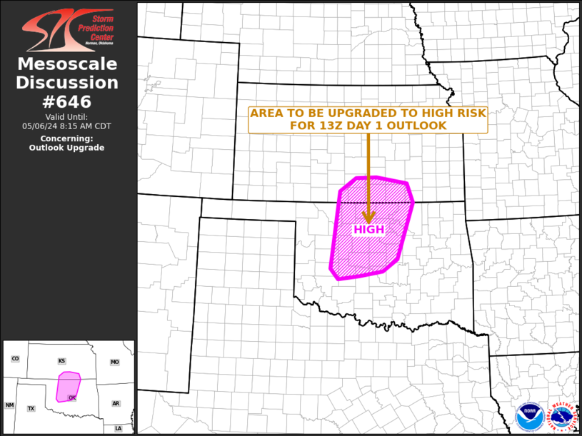
Texas Spring 2023

U.S. & Caribbean Weather Discussions and Severe Weather Events

Moderator: S2k Moderators

Forum rules

The posts in this forum are NOT official forecast and should not be used as such. They are just the opinion of the poster and may or may not be backed by sound meteorological data. They are NOT endorsed by any professional institution or STORM2K.

Help Support Storm2K
Message
Author
User avatar
EnnisTx
S2K Supporter
S2K Supporter
Posts: 896
Joined: Sat Dec 26, 2015 4:06 pm
Location: Albany, Texas
Contact:

Re: Texas Spring 2023

#1041 Postby EnnisTx » Fri Apr 28, 2023 10:35 am

Ntxw wrote:
rwfromkansas wrote:I like severe weather. But I don’t like baseball hail hitting my house. So I’m fine with missing out today. Lol.

Off-topic slightly but tied in with hail, but an alleged vague “storm” is causing huge issues for DFW home insurance. If you live in DFW and haven’t gotten home insurance renewal, expect to fall to the floor with increases since last fall. Mine they wanted to increase $1500. Caused escrow shortage. Shopped around but many now want a 2 percent minimum deductible or aren’t serving DFW at all anymore due to “storm risks” as if we haven’t always had storms. I found one cheaper policy with a 1 percent deductible I went with, but not much cheaper than the renewal. Just awful.


I felt it too, sticker shock. I've mentioned over and over as a homeowner these hail storms are becoming expensive, as a whole for everyone. It is one thing to have one or two every few years roll through the core urban metros. But multiple in the same season, over the same areas assesses a different kind of risk for insurance.

Covering a few mil in Coleman isn't the same as a similar coverage area in DFW for a bil+ $.

It has definitely been a rough year for hail across the US. Florida the past few days have experienced some of their worst hailstorms.


That stinks, glad we're only 2 months from our house being completed and moving from Dallas to near Albany Texas out in Shackelford County. Cheaper car and house insurance here we come!!
1 likes   

User avatar
bubba hotep
S2K Supporter
S2K Supporter
Posts: 5837
Joined: Wed Dec 28, 2016 1:00 am
Location: Collin County Texas

Re: Texas Spring 2023

#1042 Postby bubba hotep » Fri Apr 28, 2023 10:58 am

12z guidance appears to support holding the ENH across DFW. One interesting thing is that cells might be more discrete across DFW and not build upscale into a line as quickly as storms farther south. Still, the biggest threat appears to be in the Waco vicinity before storms quickly line out.
0 likes   
Winter time post are almost exclusively focused on the DFW area.

User avatar
Cpv17
Category 5
Category 5
Posts: 4975
Joined: Wed Dec 07, 2016 2:24 pm
Location: Wharton/El Campo, TX

Re: Texas Spring 2023

#1043 Postby Cpv17 » Fri Apr 28, 2023 11:05 am

It never hails where I live. I’ve only seen it hail 3 times my entire life at my house and the biggest was golf ball and the other 2 like marble size.
0 likes   

User avatar
txtwister78
Category 5
Category 5
Posts: 1853
Joined: Wed Jan 30, 2019 12:56 pm
Location: San Antonio

Re: Texas Spring 2023

#1044 Postby txtwister78 » Fri Apr 28, 2023 11:22 am

Cpv17 wrote:It never hails where I live. I’ve only seen it hail 3 times my entire life at my house and the biggest was golf ball and the other 2 like marble size.


I'd be celebrating that if I were you.
1 likes   

User avatar
txtwister78
Category 5
Category 5
Posts: 1853
Joined: Wed Jan 30, 2019 12:56 pm
Location: San Antonio

Re: Texas Spring 2023

#1045 Postby txtwister78 » Fri Apr 28, 2023 11:34 am

No major changes to the SPC update other than removing the DFW region from the 5% Tornado probability and significant wind damage threat. That (5% Tornado prob) has now been shifted further south into Waco region.
0 likes   

User avatar
Cpv17
Category 5
Category 5
Posts: 4975
Joined: Wed Dec 07, 2016 2:24 pm
Location: Wharton/El Campo, TX

Re: Texas Spring 2023

#1046 Postby Cpv17 » Fri Apr 28, 2023 11:40 am

txtwister78 wrote:
Cpv17 wrote:It never hails where I live. I’ve only seen it hail 3 times my entire life at my house and the biggest was golf ball and the other 2 like marble size.


I'd be celebrating that if I were you.


Yep. I’m good with it.
0 likes   

User avatar
Iceresistance
Category 5
Category 5
Posts: 9288
Age: 21
Joined: Sat Oct 10, 2020 9:45 am
Location: Tecumseh, OK/Norman, OK

Re: Texas Spring 2023

#1047 Postby Iceresistance » Fri Apr 28, 2023 11:43 am

Cpv17 wrote:
txtwister78 wrote:
Cpv17 wrote:It never hails where I live. I’ve only seen it hail 3 times my entire life at my house and the biggest was golf ball and the other 2 like marble size.


I'd be celebrating that if I were you.


Yep. I’m good with it.

I rarely get hailstorms bigger than quarters, even though I had softballs in 2011.
0 likes   
Bill 2015 & Beta 2020

Winter 2020-2021 :cold:

All observations are in Tecumseh, OK unless otherwise noted.

Winter posts are focused mainly for Oklahoma & Texas.

Take any of my forecasts with a grain of salt, refer to the NWS, SPC, and NHC for official information

Never say Never with weather! Because ANYTHING is possible!

User avatar
Ntxw
Storm2k Moderator
Storm2k Moderator
Posts: 22784
Joined: Wed Oct 21, 2009 6:34 pm
Location: DFW, Texas

Re: Texas Spring 2023

#1048 Postby Ntxw » Fri Apr 28, 2023 12:16 pm

Kind of similar issues as the other day. Warmer temps today but DP is sitting around 55 at DFW as of the noon hour. Hail, tor, and supercell parameters are around Waco to the south per meso-analysis. Assuming no drastic surges northward of better DPs well into the 60s.
1 likes   
The above post and any post by Ntxw is NOT an official forecast and should not be used as such. It is just the opinion of the poster and may or may not be backed by sound meteorological data. It is NOT endorsed by any professional institution including Storm2k. For official information, please refer to NWS products.

  Help support Storm2K!
Help Support Storm2K

User avatar
bubba hotep
S2K Supporter
S2K Supporter
Posts: 5837
Joined: Wed Dec 28, 2016 1:00 am
Location: Collin County Texas

Re: Texas Spring 2023

#1049 Postby bubba hotep » Fri Apr 28, 2023 12:49 pm

Ntxw wrote:Kind of similar issues as the other day. Warmer temps today but DP is sitting around 55 at DFW as of the noon hour. Hail, tor, and supercell parameters are around Waco to the south per meso-analysis. Assuming no drastic surges northward of better DPs well into the 60s.


If HRRR trends continue and come true, then DFW might not get much, if any, rain out of this event.
0 likes   
Winter time post are almost exclusively focused on the DFW area.

User avatar
Ntxw
Storm2k Moderator
Storm2k Moderator
Posts: 22784
Joined: Wed Oct 21, 2009 6:34 pm
Location: DFW, Texas

Re: Texas Spring 2023

#1050 Postby Ntxw » Fri Apr 28, 2023 12:54 pm

bubba hotep wrote:
Ntxw wrote:Kind of similar issues as the other day. Warmer temps today but DP is sitting around 55 at DFW as of the noon hour. Hail, tor, and supercell parameters are around Waco to the south per meso-analysis. Assuming no drastic surges northward of better DPs well into the 60s.


If HRRR trends continue and come true, then DFW might not get much, if any, rain out of this event.


Yeah a little disappointing about the rain at least. For April so far 3.06" and normal is 3.22" so a quarter inch would be nice. Temps have come down to +0.2F for the month.
0 likes   
The above post and any post by Ntxw is NOT an official forecast and should not be used as such. It is just the opinion of the poster and may or may not be backed by sound meteorological data. It is NOT endorsed by any professional institution including Storm2k. For official information, please refer to NWS products.


  Help support Storm2K!

Help Support Storm2K


User avatar
bubba hotep
S2K Supporter
S2K Supporter
Posts: 5837
Joined: Wed Dec 28, 2016 1:00 am
Location: Collin County Texas

Re: Texas Spring 2023

#1051 Postby bubba hotep » Fri Apr 28, 2023 12:56 pm

Image

Mesoscale Discussion 0646
NWS Storm Prediction Center Norman OK
1225 PM CDT Fri Apr 28 2023

Areas affected...parts of central and north Texas

Concerning...Severe potential...Watch likely

Valid 281725Z - 282000Z

Probability of Watch Issuance...95 percent

SUMMARY...Severe thunderstorms are forecast to develop this
afternoon with convective initiation expected between 2-3pm near the
triple point. Large to giant hail (1-3 inches in diameter), severe
gusts (60-80 mph) and a few tornadoes are possible over central TX.
Large hail and severe gusts are possible farther north over North
Texas.

DISCUSSION...Visible-satellite imagery shows a stratocumulus field
near and east of I-35 from San Antonio northward through Waco. This
cloud feature is located within a plume of richer low-level moisture
(ranging from the lower 60s north to upper 60s south) advancing
north in association with a warm front. Strong heating is occurring
near and south of a triple point 35 mi east of Abilene to areas
southward along and east of a dryline where temperatures are rising
through the 80s.

Model forecast soundings show enlarged hodographs by mid-late
afternoon near the warm frontal zone with a very unstable airmass
(2500-3500 J/kg MLCAPE) located from the warm front
south-southwestward into the Hill Country. As the cap erodes from
the early into the mid afternoon, explosive thunderstorm development
is expected initially near the triple point with storms rapidly
becoming supercellular. Large to giant hail is forecast with this
initial activity with a tornado risk probably developing before
additional storms and convective coalescence lead to upscale growth
into the early evening. The tornado risk will probably lessen upon
full transition to linear modes.

Farther north near the Metroplex and areas along I-20, weaker
buoyancy and less favorable hodographs according to forecast
soundings, will limit the severe risk to large hail and severe
gusts.

..Smith/Thompson.. 04/28/2023

...Please see www.spc.noaa.gov for graphic product...

ATTN...WFO...HGX...FWD...OUN...EWX...SJT...
0 likes   
Winter time post are almost exclusively focused on the DFW area.

horns0314
Tropical Low
Tropical Low
Posts: 12
Joined: Tue Feb 01, 2011 6:17 pm
Location: Dallas Texas

Re: Texas Spring 2023

#1052 Postby horns0314 » Fri Apr 28, 2023 12:58 pm

bubba hotep wrote:
Ntxw wrote:Kind of similar issues as the other day. Warmer temps today but DP is sitting around 55 at DFW as of the noon hour. Hail, tor, and supercell parameters are around Waco to the south per meso-analysis. Assuming no drastic surges northward of better DPs well into the 60s.


If HRRR trends continue and come true, then DFW might not get much, if any, rain out of this event.


Fox App future radar still has storms coming through around 5 but with dew points so low not expecting much severity.
0 likes   

horns0314
Tropical Low
Tropical Low
Posts: 12
Joined: Tue Feb 01, 2011 6:17 pm
Location: Dallas Texas

Re: Texas Spring 2023

#1053 Postby horns0314 » Fri Apr 28, 2023 1:04 pm

horns0314 wrote:
bubba hotep wrote:
Ntxw wrote:Kind of similar issues as the other day. Warmer temps today but DP is sitting around 55 at DFW as of the noon hour. Hail, tor, and supercell parameters are around Waco to the south per meso-analysis. Assuming no drastic surges northward of better DPs well into the 60s.


If HRRR trends continue and come true, then DFW might not get much, if any, rain out of this event.


Fox App future radar still has storms coming through around 4 but with dew points so low not expecting much severity.
0 likes   

User avatar
Iceresistance
Category 5
Category 5
Posts: 9288
Age: 21
Joined: Sat Oct 10, 2020 9:45 am
Location: Tecumseh, OK/Norman, OK

Re: Texas Spring 2023

#1054 Postby Iceresistance » Fri Apr 28, 2023 1:04 pm

Supercells are exploding east of Brownwood, TX

Here we go
0 likes   
Bill 2015 & Beta 2020

Winter 2020-2021 :cold:

All observations are in Tecumseh, OK unless otherwise noted.

Winter posts are focused mainly for Oklahoma & Texas.

Take any of my forecasts with a grain of salt, refer to the NWS, SPC, and NHC for official information

Never say Never with weather! Because ANYTHING is possible!

rwfromkansas
Category 5
Category 5
Posts: 2627
Joined: Sat Aug 27, 2005 12:47 am
Location: North Fort Worth

Re: Texas Spring 2023

#1055 Postby rwfromkansas » Fri Apr 28, 2023 1:08 pm

What is holding things back south? Is it that front with greater dewpoints down there?
0 likes   

User avatar
txtwister78
Category 5
Category 5
Posts: 1853
Joined: Wed Jan 30, 2019 12:56 pm
Location: San Antonio

Re: Texas Spring 2023

#1056 Postby txtwister78 » Fri Apr 28, 2023 1:21 pm

0 likes   

User avatar
Iceresistance
Category 5
Category 5
Posts: 9288
Age: 21
Joined: Sat Oct 10, 2020 9:45 am
Location: Tecumseh, OK/Norman, OK

Re: Texas Spring 2023

#1057 Postby Iceresistance » Fri Apr 28, 2023 1:46 pm

Holy crap it's already tornado warned
1 likes   
Bill 2015 & Beta 2020

Winter 2020-2021 :cold:

All observations are in Tecumseh, OK unless otherwise noted.

Winter posts are focused mainly for Oklahoma & Texas.

Take any of my forecasts with a grain of salt, refer to the NWS, SPC, and NHC for official information

Never say Never with weather! Because ANYTHING is possible!

User avatar
txtwister78
Category 5
Category 5
Posts: 1853
Joined: Wed Jan 30, 2019 12:56 pm
Location: San Antonio

Re: Texas Spring 2023

#1058 Postby txtwister78 » Fri Apr 28, 2023 1:55 pm

1 likes   

User avatar
bubba hotep
S2K Supporter
S2K Supporter
Posts: 5837
Joined: Wed Dec 28, 2016 1:00 am
Location: Collin County Texas

Re: Texas Spring 2023

#1059 Postby bubba hotep » Fri Apr 28, 2023 2:09 pm

Iceresistance wrote:Holy crap it's already tornado warned


That went from firing off to warned with the quickness. Good thing they are lining out pretty fast.
0 likes   
Winter time post are almost exclusively focused on the DFW area.

User avatar
txtwister78
Category 5
Category 5
Posts: 1853
Joined: Wed Jan 30, 2019 12:56 pm
Location: San Antonio

Re: Texas Spring 2023

#1060 Postby txtwister78 » Fri Apr 28, 2023 2:19 pm

1 likes   


Return to “USA & Caribbean Weather”

Who is online

Users browsing this forum: Google Adsense [Bot] and 18 guests