Track density with El Niño.
https://twitter.com/webberweather/status/1653396297108582400
2023 Indicators (SST, SAL, MSLP, Wind shear, Steering, Instability) and Day 16+ Models
Moderator: S2k Moderators
Forum rules

The posts in this forum are NOT official forecasts and should not be used as such. They are just the opinion of the poster and may or may not be backed by sound meteorological data. They are NOT endorsed by any professional institution or STORM2K. For official information, please refer to products from the National Hurricane Center and National Weather Service.
-
cycloneye

- Admin

- Posts: 149125
- Age: 69
- Joined: Thu Oct 10, 2002 10:54 am
- Location: San Juan, Puerto Rico
Re: 2023 Indicators (SST, SAL, MSLP, Wind shear, Steering, Instability) and Day 16+ Models
1 likes
Visit the Caribbean-Central America Weather Thread where you can find at first post web cams,radars
and observations from Caribbean basin members Click Here
and observations from Caribbean basin members Click Here
-
Category5Kaiju

- Category 5

- Posts: 4322
- Joined: Thu Dec 24, 2020 12:45 pm
- Location: Seattle and Phoenix
Re: 2023 Indicators (SST, SAL, MSLP, Wind shear, Steering, Instability) and Day 16+ Models
Florida, Bahamas, and the Lesser Antilles:

0 likes
Unless explicitly stated, all info in my posts is based on my own opinions and observations. Tropical storms and hurricanes can be extremely dangerous. Refer to an accredited weather research agency or meteorologist if you need to make serious decisions regarding an approaching storm.

-
toad strangler

- S2K Supporter

- Posts: 4546
- Joined: Sun Jul 28, 2013 3:09 pm
- Location: Earth
- Contact:
-
cycloneye
- Admin
- Posts: 149125
- Age: 69
- Joined: Thu Oct 10, 2002 10:54 am
- Location: San Juan, Puerto Rico
Re: 2023 Indicators (SST, SAL, MSLP, Wind shear, Steering, Instability) and Day 16+ Models
The very warm East Atlantic/part of MDR will cool but stay above average.
https://twitter.com/DCAreaWx/status/1653766697889812480
https://twitter.com/DCAreaWx/status/1653766697889812480
1 likes
Visit the Caribbean-Central America Weather Thread where you can find at first post web cams,radars
and observations from Caribbean basin members Click Here
and observations from Caribbean basin members Click Here
-
cycloneye
- Admin
- Posts: 149125
- Age: 69
- Joined: Thu Oct 10, 2002 10:54 am
- Location: San Juan, Puerto Rico
Re: 2023 Indicators (SST, SAL, MSLP, Wind shear, Steering, Instability) and Day 16+ Models
1 likes
Visit the Caribbean-Central America Weather Thread where you can find at first post web cams,radars
and observations from Caribbean basin members Click Here
and observations from Caribbean basin members Click Here
-
Hurricane2022

- Category 5
- Posts: 2011
- Joined: Tue Aug 23, 2022 11:38 pm
- Location: Araçatuba, Brazil
Re: 2023 Indicators (SST, SAL, MSLP, Wind shear, Steering, Instability) and Day 16+ Models
2 likes
Sorry for the bad English sometimes...!
For reliable and detailed information for any meteorological phenomenon, please consult the National Hurricane Center, Joint Typhoon Warning Center , or your local Meteo Center.
--------
ECCE OMNIA NOVA FACIAM (Ap 21,5).
For reliable and detailed information for any meteorological phenomenon, please consult the National Hurricane Center, Joint Typhoon Warning Center , or your local Meteo Center.
--------
ECCE OMNIA NOVA FACIAM (Ap 21,5).
-
Category5Kaiju
- Category 5
- Posts: 4322
- Joined: Thu Dec 24, 2020 12:45 pm
- Location: Seattle and Phoenix
Re: 2023 Indicators (SST, SAL, MSLP, Wind shear, Steering, Instability) and Day 16+ Models
If this pans out, then expect the sinister Atlantic warmth to persist for quite some time...any trade wind-induced cooling for the next week or so will likely be compensated for 

1 likes
Unless explicitly stated, all info in my posts is based on my own opinions and observations. Tropical storms and hurricanes can be extremely dangerous. Refer to an accredited weather research agency or meteorologist if you need to make serious decisions regarding an approaching storm.
-
Yellow Evan

- Professional-Met

- Posts: 16219
- Age: 27
- Joined: Fri Jul 15, 2011 12:48 pm
- Location: Henderson, Nevada/Honolulu, HI
- Contact:
Re: 2023 Indicators (SST, SAL, MSLP, Wind shear, Steering, Instability) and Day 16+ Models
2 likes
-
jconsor
- Professional-Met
- Posts: 573
- Joined: Mon Jun 30, 2008 9:31 pm
- Location: Jerusalem, Israel
- Contact:
Re: 2023 Indicators (SST, SAL, MSLP, Wind shear, Steering, Instability) and Day 16+ Models
A thread on why the Sahel rainfall/Atlantic hurricane correlation has waxed and waned, and why the expected wet Sahel/strong W. African monsoon this year is likely an important factor for the hurricane season:
https://twitter.com/yconsor/status/1654111104828596225
https://twitter.com/yconsor/status/1654115186565869568
https://twitter.com/yconsor/status/1654123545671380993
https://twitter.com/yconsor/status/1654126650890801155
https://twitter.com/yconsor/status/1654111104828596225
https://twitter.com/yconsor/status/1654115186565869568
https://twitter.com/yconsor/status/1654123545671380993
https://twitter.com/yconsor/status/1654126650890801155
5 likes
-
Category5Kaiju
- Category 5
- Posts: 4322
- Joined: Thu Dec 24, 2020 12:45 pm
- Location: Seattle and Phoenix
Re: 2023 Indicators (SST, SAL, MSLP, Wind shear, Steering, Instability) and Day 16+ Models
jconsor wrote:A thread on why the Sahel rainfall/Atlantic hurricane correlation has waxed and waned, and why the expected wet Sahel/strong W. African monsoon this year is likely an important factor for the hurricane season:
https://twitter.com/yconsor/status/1654111104828596225
https://twitter.com/yconsor/status/1654115186565869568
https://twitter.com/yconsor/status/1654123545671380993
https://twitter.com/yconsor/status/1654126650890801155
Very good and interesting analysis by Dr. Cantor there! I actually didn't realize how much of a role the wet Sahel played in those Nino years. Everyone (including me haha) seems to focus on the absurdly warm sst anomalies in the Atlantic, but if you combine that with a wet Sahel, then that could lead to some very intriguing results.
4 likes
Unless explicitly stated, all info in my posts is based on my own opinions and observations. Tropical storms and hurricanes can be extremely dangerous. Refer to an accredited weather research agency or meteorologist if you need to make serious decisions regarding an approaching storm.
-
IsabelaWeather
- Category 1

- Posts: 316
- Age: 36
- Joined: Tue Jul 07, 2020 7:29 am
- Location: Isabela, Puerto Rico
Re: 2023 Indicators (SST, SAL, MSLP, Wind shear, Steering, Instability) and Day 16+ Models
Do we know how the sahel is doing in terms of rain this year? Or is it still too far north to be getting rains yet?
0 likes
-
cycloneye
- Admin
- Posts: 149125
- Age: 69
- Joined: Thu Oct 10, 2002 10:54 am
- Location: San Juan, Puerto Rico
Re: 2023 Indicators (SST, SAL, MSLP, Wind shear, Steering, Instability) and Day 16+ Models
IsabelaWeather wrote:Do we know how the sahel is doing in terms of rain this year? Or is it still too far north to be getting rains yet?
The last 90 days until May 2 shows a relativly wet Sahel.
http://research.jisao.washington.edu/data/sahel/

2 likes
Visit the Caribbean-Central America Weather Thread where you can find at first post web cams,radars
and observations from Caribbean basin members Click Here
and observations from Caribbean basin members Click Here
-
SFLcane

- S2K Supporter
- Posts: 10281
- Age: 48
- Joined: Sat Jun 05, 2010 1:44 pm
- Location: Lake Worth Florida
Re: 2023 Indicators (SST, SAL, MSLP, Wind shear, Steering, Instability) and Day 16+ Models
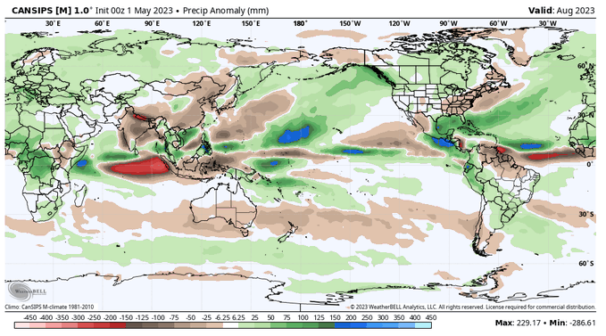
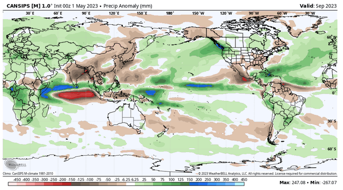
Cansips for August and September..
2 likes
-
Yellow Evan
- Professional-Met
- Posts: 16219
- Age: 27
- Joined: Fri Jul 15, 2011 12:48 pm
- Location: Henderson, Nevada/Honolulu, HI
- Contact:
Re: 2023 Indicators (SST, SAL, MSLP, Wind shear, Steering, Instability) and Day 16+ Models
3 likes
-
AutoPenalti
- Category 5
- Posts: 4091
- Age: 29
- Joined: Mon Aug 17, 2015 4:16 pm
- Location: Ft. Lauderdale, Florida
Re: 2023 Indicators (SST, SAL, MSLP, Wind shear, Steering, Instability) and Day 16+ Models
3 likes
The posts in this forum are NOT official forecasts and should not be used as such. They are just the opinion of the poster and may or may not be backed by sound meteorological data. They are NOT endorsed by any professional institution or STORM2K. For official information, please refer to products from the NHC and NWS.
Model Runs Cheat Sheet:
GFS (5:30 AM/PM, 11:30 AM/PM)
HWRF, GFDL, UKMET, NAVGEM (6:30-8:00 AM/PM, 12:30-2:00 AM/PM)
ECMWF (1:45 AM/PM)
TCVN is a weighted averaged
-
jconsor
- Professional-Met
- Posts: 573
- Joined: Mon Jun 30, 2008 9:31 pm
- Location: Jerusalem, Israel
- Contact:
Re: 2023 Indicators (SST, SAL, MSLP, Wind shear, Steering, Instability) and Day 16+ Models
The rainy season in the Sahel is from Jun to early Oct, so it's a little early to get an idea of the rainfall trend simply from current observations. See this link to learn more about Sahel rainfall: https://www.meted.ucar.edu/asmet/w_africa/navmenu.php
However, the seasonal model guidance is in good agreement on a wet Sahel, which would be in accordance with what we've seen in most years since 2015.


One factor that is likely strongly contributing to the wetter trend in the Sahel since the mid-2010s is the near record warm eastern Mediterranean, which tends to induce an anomalous low pressure over north Africa in summer and early fall.
In turn, this typically leads to enhanced southwesterly flow from the eastern Atlantic and Gulf of Guinea toward the Sahel, transporting enhanced moisture there.
These two excellent recent papers go into depth on the E. Mediterranean - Sahel linkage and how the recent extremely warm E. Medit. may be encouraging wet Sahel years even when there is an El Nino (which typically reduces Sahel rainfall).
https://link.springer.com/article/10.10 ... 22-06263-8
https://journals.ametsoc.org/view/journ ... 0367.1.xml
Some key figures from the papers:


However, the seasonal model guidance is in good agreement on a wet Sahel, which would be in accordance with what we've seen in most years since 2015.
One factor that is likely strongly contributing to the wetter trend in the Sahel since the mid-2010s is the near record warm eastern Mediterranean, which tends to induce an anomalous low pressure over north Africa in summer and early fall.
In turn, this typically leads to enhanced southwesterly flow from the eastern Atlantic and Gulf of Guinea toward the Sahel, transporting enhanced moisture there.
These two excellent recent papers go into depth on the E. Mediterranean - Sahel linkage and how the recent extremely warm E. Medit. may be encouraging wet Sahel years even when there is an El Nino (which typically reduces Sahel rainfall).
https://link.springer.com/article/10.10 ... 22-06263-8
https://journals.ametsoc.org/view/journ ... 0367.1.xml
Some key figures from the papers:
IsabelaWeather wrote:Do we know how the sahel is doing in terms of rain this year? Or is it still too far north to be getting rains yet?
6 likes
Re: 2023 Indicators (SST, SAL, MSLP, Wind shear, Steering, Instability) and Day 16+ Models

EC monthlies forecast an active Atlantic.
6 likes
Re: 2023 Indicators (SST, SAL, MSLP, Wind shear, Steering, Instability) and Day 16+ Models


Euro also shows a huge AMO+ and a fairly wet Atlantic for peak hurricane season.
2 likes