Texas Spring 2023

U.S. & Caribbean Weather Discussions and Severe Weather Events

Moderator: S2k Moderators

Forum rules

The posts in this forum are NOT official forecast and should not be used as such. They are just the opinion of the poster and may or may not be backed by sound meteorological data. They are NOT endorsed by any professional institution or STORM2K.

Help Support Storm2K
Message
Author
User avatar
Cpv17
Category 5
Category 5
Posts: 4975
Joined: Wed Dec 07, 2016 2:24 pm
Location: Wharton/El Campo, TX

Re: Texas Spring 2023

#1101 Postby Cpv17 » Wed May 03, 2023 8:24 am

Brent wrote:Well I have daily storm chances pretty much after the heat wave Friday and Saturday so I expect things to start ramping up soon on the severe front


This coming setup seems like your daily scattered afternoon and evening thunderstorms that start dying out when the sun goes down. One of those events where you could get nothing but 5 miles down the road gets a flood. But no worries cuz you could get some the next day. And I think there will be a marginal to slight risk of severe weather each day. Mainly for large hail and high winds. At least that’s the impression I’m getting.
0 likes   

rwfromkansas
Category 5
Category 5
Posts: 2627
Joined: Sat Aug 27, 2005 12:47 am
Location: North Fort Worth

Re: Texas Spring 2023

#1102 Postby rwfromkansas » Wed May 03, 2023 8:46 am

Cpv17 wrote:
Brent wrote:Well I have daily storm chances pretty much after the heat wave Friday and Saturday so I expect things to start ramping up soon on the severe front


This coming setup seems like your daily scattered afternoon and evening thunderstorms that start dying out when the sun goes down. One of those events where you could get nothing but 5 miles down the road gets a flood. But no worries cuz you could get some the next day. And I think there will be a marginal to slight risk of severe weather each day. Mainly for large hail and high winds. At least that’s the impression I’m getting.


Yeah the talk of the storms dying quickly east of 35 on Friday indicates a more pulse-type storm, not more spring supercell outbreak.
0 likes   

User avatar
Iceresistance
Category 5
Category 5
Posts: 9288
Age: 21
Joined: Sat Oct 10, 2020 9:45 am
Location: Tecumseh, OK/Norman, OK

Re: Texas Spring 2023

#1103 Postby Iceresistance » Wed May 03, 2023 8:47 am

rwfromkansas wrote:
Cpv17 wrote:
Brent wrote:Well I have daily storm chances pretty much after the heat wave Friday and Saturday so I expect things to start ramping up soon on the severe front


This coming setup seems like your daily scattered afternoon and evening thunderstorms that start dying out when the sun goes down. One of those events where you could get nothing but 5 miles down the road gets a flood. But no worries cuz you could get some the next day. And I think there will be a marginal to slight risk of severe weather each day. Mainly for large hail and high winds. At least that’s the impression I’m getting.

Yeah the talk of the storms dying quickly east of 35 on Friday indicates a more pulse-type storm, not more spring supercell outbreak.

Well, it is different over Oklahoma, there could be Supercells here instead of the typical popcorn storms in the Summer.
0 likes   
Bill 2015 & Beta 2020

Winter 2020-2021 :cold:

All observations are in Tecumseh, OK unless otherwise noted.

Winter posts are focused mainly for Oklahoma & Texas.

Take any of my forecasts with a grain of salt, refer to the NWS, SPC, and NHC for official information

Never say Never with weather! Because ANYTHING is possible!

rwfromkansas
Category 5
Category 5
Posts: 2627
Joined: Sat Aug 27, 2005 12:47 am
Location: North Fort Worth

Re: Texas Spring 2023

#1104 Postby rwfromkansas » Wed May 03, 2023 8:51 am

Yeah, I think OK is closer to the dynamics, so stronger storms.
1 likes   

User avatar
Iceresistance
Category 5
Category 5
Posts: 9288
Age: 21
Joined: Sat Oct 10, 2020 9:45 am
Location: Tecumseh, OK/Norman, OK

Re: Texas Spring 2023

#1105 Postby Iceresistance » Wed May 03, 2023 9:51 am

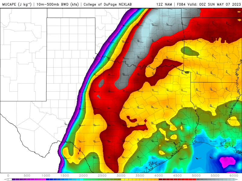
Holy bejeebers, the 12z NAM is... just... wow.
(Most Unstable CAPE, the inversion is weak)
Image
https://s12.gifyu.com/images/12z-NAM.png
0 likes   
Bill 2015 & Beta 2020

Winter 2020-2021 :cold:

All observations are in Tecumseh, OK unless otherwise noted.

Winter posts are focused mainly for Oklahoma & Texas.

Take any of my forecasts with a grain of salt, refer to the NWS, SPC, and NHC for official information

Never say Never with weather! Because ANYTHING is possible!

User avatar
Cpv17
Category 5
Category 5
Posts: 4975
Joined: Wed Dec 07, 2016 2:24 pm
Location: Wharton/El Campo, TX

Re: Texas Spring 2023

#1106 Postby Cpv17 » Wed May 03, 2023 9:57 am

rwfromkansas wrote:
Cpv17 wrote:
Brent wrote:Well I have daily storm chances pretty much after the heat wave Friday and Saturday so I expect things to start ramping up soon on the severe front


This coming setup seems like your daily scattered afternoon and evening thunderstorms that start dying out when the sun goes down. One of those events where you could get nothing but 5 miles down the road gets a flood. But no worries cuz you could get some the next day. And I think there will be a marginal to slight risk of severe weather each day. Mainly for large hail and high winds. At least that’s the impression I’m getting.


Yeah the talk of the storms dying quickly east of 35 on Friday indicates a more pulse-type storm, not more spring supercell outbreak.


Next week looks better for Texas.
0 likes   

User avatar
Cpv17
Category 5
Category 5
Posts: 4975
Joined: Wed Dec 07, 2016 2:24 pm
Location: Wharton/El Campo, TX

Re: Texas Spring 2023

#1107 Postby Cpv17 » Wed May 03, 2023 10:06 am

Iceresistance wrote:
rwfromkansas wrote:
Cpv17 wrote:
This coming setup seems like your daily scattered afternoon and evening thunderstorms that start dying out when the sun goes down. One of those events where you could get nothing but 5 miles down the road gets a flood. But no worries cuz you could get some the next day. And I think there will be a marginal to slight risk of severe weather each day. Mainly for large hail and high winds. At least that’s the impression I’m getting.


Yeah the talk of the storms dying quickly east of 35 on Friday indicates a more pulse-type storm, not more spring supercell outbreak.

Well, it is different over Oklahoma, there could be Supercells here instead of the typical popcorn storms in the Summer.


You can still get supercells from scattered diurnal driven storms that can turn severe. Maybe just not as much of them and the movement won’t be as fast so wherever they do form they could really dump the rain. And they probably won’t congeal into an MCS that doesn’t die off till the next morning.
1 likes   

User avatar
txtwister78
Category 5
Category 5
Posts: 1851
Joined: Wed Jan 30, 2019 12:56 pm
Location: San Antonio

Re: Texas Spring 2023

#1108 Postby txtwister78 » Wed May 03, 2023 10:47 am

The setup both tomorrow and Friday across Texas continues to look conditional based on how quickly (if at all) the cap weakens in the afternoon. Models remain somewhat split in determining that factor. Surface temps may offer some clues but those also vary model to model (how fast does cloud cover break) and so not surprised to see the overall variability of QPF/reflectivity simulation depicted.

Latest HRRR, FV3, Texas Tech WRF and to some degree NSSL appear to be the most bullish on severe storms breaking out tomorrow afternoon from portions of Central Texas down into SC Texas. Instability parameters appear to be highest across SC TX hence the SPC outline for very large hail across the Edwards Plateau region should storms develop there.
0 likes   

User avatar
txtwister78
Category 5
Category 5
Posts: 1851
Joined: Wed Jan 30, 2019 12:56 pm
Location: San Antonio

Re: Texas Spring 2023

#1109 Postby txtwister78 » Wed May 03, 2023 12:32 pm

1 likes   

User avatar
wxman22
Category 5
Category 5
Posts: 1492
Joined: Mon Jan 30, 2006 12:39 am
Location: Wichita Falls, TX
Contact:

Re: Texas Spring 2023

#1110 Postby wxman22 » Wed May 03, 2023 10:27 pm

Cpv17 wrote:
Brent wrote:Well I have daily storm chances pretty much after the heat wave Friday and Saturday so I expect things to start ramping up soon on the severe front


This coming setup seems like your daily scattered afternoon and evening thunderstorms that start dying out when the sun goes down. One of those events where you could get nothing but 5 miles down the road gets a flood. But no worries cuz you could get some the next day. And I think there will be a marginal to slight risk of severe weather each day. Mainly for large hail and high winds. At least that’s the impression I’m getting.


Completely agree,there may be more widespread rain next week,but this week looks to be hit or miss with the showers/storms.The luck of the draw...
1 likes   

User avatar
Iceresistance
Category 5
Category 5
Posts: 9288
Age: 21
Joined: Sat Oct 10, 2020 9:45 am
Location: Tecumseh, OK/Norman, OK

Re: Texas Spring 2023

#1111 Postby Iceresistance » Thu May 04, 2023 7:44 am

Quick 1/4 inch from a complex this morning
1 likes   
Bill 2015 & Beta 2020

Winter 2020-2021 :cold:

All observations are in Tecumseh, OK unless otherwise noted.

Winter posts are focused mainly for Oklahoma & Texas.

Take any of my forecasts with a grain of salt, refer to the NWS, SPC, and NHC for official information

Never say Never with weather! Because ANYTHING is possible!

User avatar
ElectricStorm
Category 5
Category 5
Posts: 5044
Age: 24
Joined: Tue Aug 13, 2019 11:23 pm
Location: Skiatook, OK / Norman, OK

Re: Texas Spring 2023

#1112 Postby ElectricStorm » Thu May 04, 2023 7:50 am

This morning convection seemed to be decently strong, that's probably going to significantly limit severe potential later today in OK. SPC already removed the 5% tor area and 15% wind area and trimmed the slight risk to the west. Wouldn't surprise me if they remove it entirely from OK next update. Hopefully we can get a decent storm later still, but looking less likely.
0 likes   
B.S Meteorology, University of Oklahoma '25

Please refer to the NHC, NWS, or SPC for official information.

rwfromkansas
Category 5
Category 5
Posts: 2627
Joined: Sat Aug 27, 2005 12:47 am
Location: North Fort Worth

Re: Texas Spring 2023

#1113 Postby rwfromkansas » Thu May 04, 2023 9:10 am

After expanding east, SPC keeps pulling it west. I'm now basically on the eastern edge of slight risk.

I'm not expecting anything after looking at the HRRR and NAM.
1 likes   

User avatar
txtwister78
Category 5
Category 5
Posts: 1851
Joined: Wed Jan 30, 2019 12:56 pm
Location: San Antonio

Re: Texas Spring 2023

#1114 Postby txtwister78 » Thu May 04, 2023 10:38 am

wxman22 wrote:
Cpv17 wrote:
Brent wrote:Well I have daily storm chances pretty much after the heat wave Friday and Saturday so I expect things to start ramping up soon on the severe front


This coming setup seems like your daily scattered afternoon and evening thunderstorms that start dying out when the sun goes down. One of those events where you could get nothing but 5 miles down the road gets a flood. But no worries cuz you could get some the next day. And I think there will be a marginal to slight risk of severe weather each day. Mainly for large hail and high winds. At least that’s the impression I’m getting.


Completely agree,there may be more widespread rain next week,but this week looks to be hit or miss with the showers/storms.The luck of the draw...


Drylines by themselves (without a cold front or some other forcing mechanism) are inefficient makers of thunderstorms. Might be a case going forward where we watch old storm boundaries from the previous day to help predict location for development.

Overall agree the next few days definitely can best be described as a hit or miss type setup but if you get one (especially down across SC TX where instability today will be the highest) then look out for large hail and a quick 1-2 inches of rain.
2 likes   

User avatar
ElectricStorm
Category 5
Category 5
Posts: 5044
Age: 24
Joined: Tue Aug 13, 2019 11:23 pm
Location: Skiatook, OK / Norman, OK

Re: Texas Spring 2023

#1115 Postby ElectricStorm » Thu May 04, 2023 11:39 am

As expected, most of OK has been downgraded to marginal. Looks like a small area of favorable tornado potential could materialize in far SW OK/NW TX along the red river, where a 5% tor area has been added.

Getting some solid rain/non severe storms though, so I'm certainly not complaining. I'd much rather have this than something like 2/26 or 4/19
Last edited by ElectricStorm on Thu May 04, 2023 11:40 am, edited 1 time in total.
2 likes   
B.S Meteorology, University of Oklahoma '25

Please refer to the NHC, NWS, or SPC for official information.

rwfromkansas
Category 5
Category 5
Posts: 2627
Joined: Sat Aug 27, 2005 12:47 am
Location: North Fort Worth

Re: Texas Spring 2023

#1116 Postby rwfromkansas » Thu May 04, 2023 11:39 am

HRRR is bringing back some rain for northern metro, but still blanks most of DFW.
1 likes   

gpsnowman
S2K Supporter
S2K Supporter
Posts: 3185
Joined: Fri Jan 07, 2011 10:35 am
Location: Grand Prairie Tx

Re: Texas Spring 2023

#1117 Postby gpsnowman » Thu May 04, 2023 11:56 am

rwfromkansas wrote:HRRR is bringing back some rain for northern metro, but still blanks most of DFW.

If it ain't shifting east it's shifting west. Frustrating. :x
Someone will get wet and that is always good. Let's get Texas soaked.
1 likes   

User avatar
Cpv17
Category 5
Category 5
Posts: 4975
Joined: Wed Dec 07, 2016 2:24 pm
Location: Wharton/El Campo, TX

Re: Texas Spring 2023

#1118 Postby Cpv17 » Thu May 04, 2023 12:44 pm

Y’all shouldn’t worry about today if you get rain or not. There’s plenty of chances for rain over the next couple weeks.
4 likes   

User avatar
bubba hotep
S2K Supporter
S2K Supporter
Posts: 5837
Joined: Wed Dec 28, 2016 1:00 am
Location: Collin County Texas

Re: Texas Spring 2023

#1119 Postby bubba hotep » Thu May 04, 2023 1:20 pm

Cpv17 wrote:Y’all shouldn’t worry about today if you get rain or not. There’s plenty of chances for rain over the next couple weeks.


Image
1 likes   
Winter time post are almost exclusively focused on the DFW area.

Brent
S2K Supporter
S2K Supporter
Posts: 38088
Age: 36
Joined: Sun May 16, 2004 10:30 pm
Location: Tulsa Oklahoma
Contact:

Re: Texas Spring 2023

#1120 Postby Brent » Thu May 04, 2023 1:31 pm

ElectricStorm wrote:As expected, most of OK has been downgraded to marginal. Looks like a small area of favorable tornado potential could materialize in far SW OK/NW TX along the red river, where a 5% tor area has been added.

Getting some solid rain/non severe storms though, so I'm certainly not complaining. I'd much rather have this than something like 2/26 or 4/19


Rain is definitely overperforming here for sure
1 likes   
#neversummer


Return to “USA & Caribbean Weather”

Who is online

Users browsing this forum: IamKelleyP and 17 guests