Texas Spring 2023
Moderator: S2k Moderators
Forum rules

The posts in this forum are NOT official forecast and should not be used as such. They are just the opinion of the poster and may or may not be backed by sound meteorological data. They are NOT endorsed by any professional institution or STORM2K.
-
rwfromkansas
- Category 5

- Posts: 3032
- Joined: Sat Aug 27, 2005 12:47 am
- Location: North Fort Worth
-
txtwister78

- Category 5
- Posts: 2176
- Joined: Wed Jan 30, 2019 12:56 pm
- Location: San Antonio
Re: Texas Spring 2023
Monster supercell SW of San Antonio about to hit Crystal City. Definitely a big hailer.
https://twitter.com/NWSSanAntonio/status/1654316051562385409
https://twitter.com/NWSSanAntonio/status/1654316051562385409
1 likes

Re: Texas Spring 2023
txtwister78 wrote:Monster supercell SW of San Antonio about to hit Crystal City. Definitely a big hailer.
https://twitter.com/NWSSanAntonio/status/1654316051562385409?s=20
Cotulla next in line for it. Tons of thunderstorms coming off the mountains in Mexico.
1 likes
-
ElectricStorm

- Category 5
- Posts: 5145
- Age: 25
- Joined: Tue Aug 13, 2019 11:23 pm
- Location: Norman, OK
Re: Texas Spring 2023
ElectricStorm wrote:Iceresistance wrote:18z HRRR shows that there is a Supercell threat for DFW tonight, and there is a non-zero chance for storms on Friday, even though I strongly doubt any will develop in Central Oklahoma because of stronger inversion with weaker instability.
Saturday? Well, that is much more likely...
As of right now, I don't really see Saturday being a big event overall. There will probably be some big parameters but not a whole lot in terms of actual storms. That being said though, it's May so most days will see severe weather somewhere, and more than likely one or both of the marginal risk areas get upgraded to slight.
Personally I'm more interested in Sunday for now, I think it's got some decent potential for a bigger event, but we'll see.
Well the 0z HRRR fires multiple supercells on Saturday from C OK down into TX. 48hr HRRR isn't the most reliable but I was expecting it to show less than that. Interested to see what the SPC does for the Day 2 outlook in a couple hours.
Probably will have pretty big parameters across the area, although shear looks pretty low. Could be concerning if models start trending towards more convection firing.
0 likes
B.S Meteorology, University of Oklahoma '25
Please refer to the NHC, NWS, or SPC for official information.
Please refer to the NHC, NWS, or SPC for official information.
-
Iceresistance

- Category 5
- Posts: 9581
- Age: 22
- Joined: Sat Oct 10, 2020 9:45 am
- Location: Tecumseh, OK/Norman, OK
Re: Texas Spring 2023
ElectricStorm wrote:ElectricStorm wrote:Iceresistance wrote:18z HRRR shows that there is a Supercell threat for DFW tonight, and there is a non-zero chance for storms on Friday, even though I strongly doubt any will develop in Central Oklahoma because of stronger inversion with weaker instability.
Saturday? Well, that is much more likely...
As of right now, I don't really see Saturday being a big event overall. There will probably be some big parameters but not a whole lot in terms of actual storms. That being said though, it's May so most days will see severe weather somewhere, and more than likely one or both of the marginal risk areas get upgraded to slight.
Personally I'm more interested in Sunday for now, I think it's got some decent potential for a bigger event, but we'll see.
Well the 0z HRRR fires multiple supercells on Saturday from C OK down into TX. 48hr HRRR isn't the most reliable but I was expecting it to show less than that. Interested to see what the SPC does for the Day 2 outlook in a couple hours.
Probably will have pretty big parameters across the area, although shear looks pretty low. Could be concerning if models start trending towards more convection firing.
6z has the same thing, even the NAM is starting to show it too.
I think the models are up to something...
0 likes
Bill 2015 & Beta 2020
Winter 2020-2021
All observations are in Tecumseh, OK unless otherwise noted.
Winter posts are focused mainly for Oklahoma & Texas.
Take any of my forecasts with a grain of salt, refer to the NWS, SPC, and NHC for official information
Never say Never with weather! Because ANYTHING is possible!
Winter 2020-2021
All observations are in Tecumseh, OK unless otherwise noted.
Winter posts are focused mainly for Oklahoma & Texas.
Take any of my forecasts with a grain of salt, refer to the NWS, SPC, and NHC for official information
Never say Never with weather! Because ANYTHING is possible!
-
Edwards Limestone

- S2K Supporter

- Posts: 510
- Age: 36
- Joined: Tue Dec 28, 2021 11:05 am
- Location: Smithson Valley, TX
Re: Texas Spring 2023
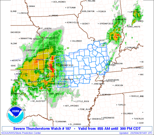
https://twitter.com/NWSSPC/status/1654458229601243138
https://www.spc.noaa.gov/products/outlook/day1otlk.html
https://www.spc.noaa.gov/products/outlook/day1otlk.html
SPC AC 051205
Day 1 Convective Outlook
NWS Storm Prediction Center Norman OK
0705 AM CDT Fri May 05 2023
Valid 051300Z - 061200Z
...THERE IS A SLIGHT RISK OF SEVERE THUNDERSTORMS PARTS OF CENTRAL
TX AND THE CENTRAL GREAT PLAINS...
...SUMMARY...
Isolated to scattered severe thunderstorms are most likely across a
portion of central Texas and in the central Great Plains, centered
on 4 to 10 PM CDT. Large hail should be the primary hazard in terms
of coverage.
...Central TX vicinity...
In the wake of a low-amplitude shortwave impulse over the Lower MS
Valley, a low-amplitude mid-level ridge axis should become centered
over east TX through central NE at 21Z. Compared to yesterday, full
insolation will allow the dryline to mix farther east into central
OK, arcing south-southwest to the Edwards Plateau. Above-normal
agreement appears within guidance in indicating high-based
convection likely forming as surface temperatures approach the mid
to upper 90s across the Big Country vicinity. This activity will
deepen into at least isolated thunderstorms during the late
afternoon as it impinges on large warm-sector buoyancy over central
TX. Despite weak low-level flow, 30-40 kt effective bulk shear will
support a few slow-moving supercells with mid-level rotation capable
of producing very large hail. More prominent MLCIN deeper into the
warm sector and especially in time after sunset, along with a lack
of synoptic-scale ascent suggests that the spatiotemporal extent of
the threat will likely be limited. Thus, large hail should be the
primary hazard, but locally damaging severe wind gusts will be
possible given the ample CAPE/steep lapse rate environment.
...Central Great Plains...
A low-amplitude shortwave impulse embedded within the broader trough
across the West should track from the Lower CO Valley to the central
High Plains, impinging on a low-amplitude mid-level ridge that
should gradually progress east from the High Plains towards IA/MO
through early Saturday. This will encourage diurnal sharpening of
the lee trough with a cyclone becoming established over eastern CO.
This low will track east and weaken across northern KS tonight.
Scattered high-based thunderstorms will initially develop along the
lee trough across eastern WY into northeast CO during the mid to
late afternoon. The most concentrated corridor of sustained
thunderstorms into the evening should spread across western to
central NE and northwest KS, as activity impinges on the plume of
mainly 50s surface dew points over the central Great Plains.
Lower-level wind profiles will be weak initially, but some
elongation to a nearly straight-line hodograph should favor a few
sustained supercells. An increase in low-level southeasterlies is
expected during the evening, but this orientation will yield
increasing MLCIN spreading northwest from central/eastern KS and
modulate the severe threat tonight. As such, large hail should be
the main hazard with strong to locally severe wind gusts also
possible.
...Lower MS Valley...
A convectively aided low-amplitude shortwave impulse has been
coincident with an eastward-moving non-severe MCS across MS and
southeast LA. The stronger convection has been confined to the far
southern portion near the surface warm front. There will be a small
temporal window for intensification in a narrow swath before it
largely pushes off the central Gulf Coast later this morning.
Guidance is insistent that composite outflow/warm front trailing in
its wake to the northwest will serve as a focus for regenerative
thunderstorm development through early evening along and to the cool
side of the boundary, despite the shortwave impulse shifting east
and the elevated mixed layer impinging from TX. The first round of
this scenario appears to be underway with elevated convection
developing near the Ark-La-Tex, which may spread southeast through
the day. This type of setup should largely favor a cluster type
mode. With weakening low-level winds through the day, the sustenance
of embedded supercells is uncertain. A mix of isolated large hail
and damaging winds appears plausible, most likely centered on the
late afternoon.
..Grams/Kerr.. 05/05/2023
0 likes
The above post is NOT an official forecast and should not be used as such. It is just the opinion of the poster and may or may not be backed by sound meteorological data. It is NOT endorsed by any professional institution including Storm2k. For official information, please refer to NWS products.
-
txtwister78
- Category 5
- Posts: 2176
- Joined: Wed Jan 30, 2019 12:56 pm
- Location: San Antonio
Re: Texas Spring 2023
Looks like the Waco region is going to be the target area for severe weather today.
0 likes
-
rwfromkansas
- Category 5
- Posts: 3032
- Joined: Sat Aug 27, 2005 12:47 am
- Location: North Fort Worth
-
Iceresistance
- Category 5
- Posts: 9581
- Age: 22
- Joined: Sat Oct 10, 2020 9:45 am
- Location: Tecumseh, OK/Norman, OK
Re: Texas Spring 2023
I see something going up just west of DFW
1 likes
Bill 2015 & Beta 2020
Winter 2020-2021
All observations are in Tecumseh, OK unless otherwise noted.
Winter posts are focused mainly for Oklahoma & Texas.
Take any of my forecasts with a grain of salt, refer to the NWS, SPC, and NHC for official information
Never say Never with weather! Because ANYTHING is possible!
Winter 2020-2021
All observations are in Tecumseh, OK unless otherwise noted.
Winter posts are focused mainly for Oklahoma & Texas.
Take any of my forecasts with a grain of salt, refer to the NWS, SPC, and NHC for official information
Never say Never with weather! Because ANYTHING is possible!
-
rwfromkansas
- Category 5
- Posts: 3032
- Joined: Sat Aug 27, 2005 12:47 am
- Location: North Fort Worth
Re: Texas Spring 2023
Euro/GFS really cutting back rain next week to just the typical inch or 2 for DFW.
1 likes
-
bubba hotep

- S2K Supporter
- Posts: 6014
- Joined: Wed Dec 28, 2016 1:00 am
- Location: Collin County Texas
Re: Texas Spring 2023
Today felt like the first huge CAPE day on my lunch run.
0 likes
Winter time post are almost exclusively focused on the DFW area.
-
Edwards Limestone
- S2K Supporter
- Posts: 510
- Age: 36
- Joined: Tue Dec 28, 2021 11:05 am
- Location: Smithson Valley, TX
Re: Texas Spring 2023
Iceresistance wrote:I see something going up just west of DFW
rwfromkansas wrote:Waco is central right now it seems.

https://www.spc.noaa.gov/products/md/md0681.html
Mesoscale Discussion 0681
NWS Storm Prediction Center Norman OK
0242 PM CDT Fri May 05 2023
Areas affected...central Texas
Concerning...Severe potential...Watch likely
Valid 051942Z - 052145Z
Probability of Watch Issuance...80 percent
SUMMARY...Scattered storms are expected to form over the next few
hours across central Texas, with a threat of severe hail and a few
severe gusts.
DISCUSSION...A CU field continues to expand over parts of the
Edwards Plateau, with additional towering CU extending
east/northeast toward Denton. Strong heating over the elevated
terrain has led to an uncapped air mass, with modest destabilization
currently as dewpoints have mixed. Coincidentally, all of this
convection happens to be colocated with the 850 mb theta-e ridge.
With time, and despite only weak convergence, a few storms will
likely emerge out of the coalescing CU field, with a threat of
locally damaging hail or severe gusts. Mid to high level winds are
not particularly strong, suggesting multicell storm mode with
sporadic strong cores and updrafts propagating in various
directions, with downdrafts aided by the well-mixed boundary layer.
..Jewell/Guyer.. 05/05/2023
1 likes
The above post is NOT an official forecast and should not be used as such. It is just the opinion of the poster and may or may not be backed by sound meteorological data. It is NOT endorsed by any professional institution including Storm2k. For official information, please refer to NWS products.
-
bubba hotep
- S2K Supporter
- Posts: 6014
- Joined: Wed Dec 28, 2016 1:00 am
- Location: Collin County Texas
Re: Texas Spring 2023
Iceresistance wrote:I see something going up just west of DFW
If that updraft can get surface based and survive, then it will trek into a decent parameter space as it moves eastward.
0 likes
Winter time post are almost exclusively focused on the DFW area.
-
bubba hotep
- S2K Supporter
- Posts: 6014
- Joined: Wed Dec 28, 2016 1:00 am
- Location: Collin County Texas
-
bubba hotep
- S2K Supporter
- Posts: 6014
- Joined: Wed Dec 28, 2016 1:00 am
- Location: Collin County Texas
-
bubba hotep
- S2K Supporter
- Posts: 6014
- Joined: Wed Dec 28, 2016 1:00 am
- Location: Collin County Texas
Re: Texas Spring 2023
Looks like another day of storms avoiding DFW
Starting to fall behind on the year for rainfall...
Starting to fall behind on the year for rainfall...
0 likes
Winter time post are almost exclusively focused on the DFW area.
-
bubba hotep
- S2K Supporter
- Posts: 6014
- Joined: Wed Dec 28, 2016 1:00 am
- Location: Collin County Texas
Re: Texas Spring 2023
rwfromkansas wrote:Euro/GFS really cutting back rain next week to just the typical inch or 2 for DFW.
Ensembles still look good in the longer range lol
Can't move inside 5 days for the past two months.
0 likes
Winter time post are almost exclusively focused on the DFW area.
-
Iceresistance
- Category 5
- Posts: 9581
- Age: 22
- Joined: Sat Oct 10, 2020 9:45 am
- Location: Tecumseh, OK/Norman, OK
Re: Texas Spring 2023
Supercell incoming for Round Rock, TX
0 likes
Bill 2015 & Beta 2020
Winter 2020-2021
All observations are in Tecumseh, OK unless otherwise noted.
Winter posts are focused mainly for Oklahoma & Texas.
Take any of my forecasts with a grain of salt, refer to the NWS, SPC, and NHC for official information
Never say Never with weather! Because ANYTHING is possible!
Winter 2020-2021
All observations are in Tecumseh, OK unless otherwise noted.
Winter posts are focused mainly for Oklahoma & Texas.
Take any of my forecasts with a grain of salt, refer to the NWS, SPC, and NHC for official information
Never say Never with weather! Because ANYTHING is possible!
-
cheezyWXguy

- Category 5
- Posts: 6282
- Joined: Mon Feb 13, 2006 12:29 am
- Location: Dallas, TX
Re: Texas Spring 2023
Well the 18z nam certainly isn’t panning out. Hrrr did a bit better in keeping things south but still underdid coverage. Not a great day for the cams in terms of precip depiction
1 likes
-
txtwister78
- Category 5
- Posts: 2176
- Joined: Wed Jan 30, 2019 12:56 pm
- Location: San Antonio
Re: Texas Spring 2023
cheezyWXguy wrote:Well the 18z nam certainly isn’t panning out. Hrrr did a bit better in keeping things south but still underdid coverage. Not a great day for the cams in terms of precip depiction
Yeah you might as well throw most of these out cycle to cycle in patterns like this where you have very little in the way of forcing other than weak impulses and leftover boundaries from the previous day storms. Really a crapshoot in terms of predicting/forecasting. An isolated storm has developed west of SA and HRRR wasn't really on that until the last two runs.
Generally speaking, the Central Texas target area was fairly accurate today though.
0 likes
Return to “USA & Caribbean Weather”
Who is online
Users browsing this forum: A1A, CaptinCrunch, Cpv17, Stratton23, txtwister78 and 196 guests