2023 Global Model Runs Discussion (Out thru day 16)
Moderator: S2k Moderators
Forum rules

The posts in this forum are NOT official forecasts and should not be used as such. They are just the opinion of the poster and may or may not be backed by sound meteorological data. They are NOT endorsed by any professional institution or STORM2K. For official information, please refer to products from the National Hurricane Center and National Weather Service.
-
wxman57

- Moderator-Pro Met

- Posts: 23175
- Age: 68
- Joined: Sat Jun 21, 2003 8:06 pm
- Location: Houston, TX (southwest)
Re: 2023 Global Model Runs Discussion (Out thru day 16)
I think that the NHC will be mentioning it tomorrow. Frontal associations haven't prevent naming in the past. I'd say 70-80% chance NHC will call it Arlene Friday evening. 100% chance it will be a 35-40 kt low center.
6 likes
-
DorkyMcDorkface

- Category 5

- Posts: 1039
- Age: 28
- Joined: Mon Sep 30, 2019 1:32 pm
- Location: Mid-Atlantic
Re: 2023 Global Model Runs Discussion (Out thru day 16)
cycloneye wrote:https://twitter.com/AndyHazelton/status/1661071731300204549
Think he's right, the PV cross-section isn't exactly indicative of an (S)TC:

1 likes
Please note the thoughts expressed by this account are solely those of the user and are from a hobbyist perspective. For more comprehensive analysis, consult an actual professional meteorologist or meteorological agency.
Floyd 1999 | Isabel 2003 | Hanna 2008 | Irene 2011 | Sandy 2012 | Isaias 2020
-
wxman57
- Moderator-Pro Met
- Posts: 23175
- Age: 68
- Joined: Sat Jun 21, 2003 8:06 pm
- Location: Houston, TX (southwest)
Re: 2023 Global Model Runs Discussion (Out thru day 16)
I don't think that the NHC will ignore a 30-40 kt low affecting the Carolinas right near the start of the hurricane season. Here comes Arlene.
3 likes
-
cycloneye

- Admin

- Posts: 149686
- Age: 69
- Joined: Thu Oct 10, 2002 10:54 am
- Location: San Juan, Puerto Rico
Re: 2023 Global Model Runs Discussion (Out thru day 16)
Tropical Weather Outlook
NWS National Hurricane Center Miami FL
800 PM EDT Tue May 23 2023
For the North Atlantic...Caribbean Sea and the Gulf of Mexico:
Tropical cyclone formation is not expected during the next 7 days.
$$
Forecaster Papin/Blake
NWS National Hurricane Center Miami FL
800 PM EDT Tue May 23 2023
For the North Atlantic...Caribbean Sea and the Gulf of Mexico:
Tropical cyclone formation is not expected during the next 7 days.
$$
Forecaster Papin/Blake
0 likes
Visit the Caribbean-Central America Weather Thread where you can find at first post web cams,radars
and observations from Caribbean basin members Click Here
and observations from Caribbean basin members Click Here
-
cycloneye
- Admin
- Posts: 149686
- Age: 69
- Joined: Thu Oct 10, 2002 10:54 am
- Location: San Juan, Puerto Rico
Re: 2023 Global Model Runs Discussion (Out thru day 16)
Another day without a mention.
Tropical Weather Outlook
NWS National Hurricane Center Miami FL
800 AM EDT Wed May 24 2023
For the North Atlantic...Caribbean Sea and the Gulf of Mexico:
Tropical cyclone formation is not expected during the next 7 days.
$$
Forecaster Reinhart
NWS National Hurricane Center Miami FL
800 AM EDT Wed May 24 2023
For the North Atlantic...Caribbean Sea and the Gulf of Mexico:
Tropical cyclone formation is not expected during the next 7 days.
$$
Forecaster Reinhart
0 likes
Visit the Caribbean-Central America Weather Thread where you can find at first post web cams,radars
and observations from Caribbean basin members Click Here
and observations from Caribbean basin members Click Here
-
AlanSnyder35
- Tropical Low

- Posts: 21
- Joined: Sat Apr 22, 2023 2:41 pm
Re: 2023 Global Model Runs Discussion (Out thru day 16)
wxman57 wrote:I don't think that the NHC will ignore a 30-40 kt low affecting the Carolinas right near the start of the hurricane season. Here comes Arlene.
Don't think they will mark it. they would have done so by now
0 likes
-
wxman57
- Moderator-Pro Met
- Posts: 23175
- Age: 68
- Joined: Sat Jun 21, 2003 8:06 pm
- Location: Houston, TX (southwest)
Re: 2023 Global Model Runs Discussion (Out thru day 16)
One thing I notice is that both the GFS & EC are predicting coastal temps in the 50s Fri/Sat as the low winds up. Not exactly a tropical airmass. Winds offshore 30-45 mph. Coastal winds probably 25-35 mph GA-SC with 3-6 inches of rain. Low inland by Saturday night. Not a pleasant beach weekend.
1 likes
-
Category5Kaiju

- Category 5
- Posts: 4345
- Joined: Thu Dec 24, 2020 12:45 pm
- Location: Seattle during the summer, Phoenix during the winter
Re: 2023 Global Model Runs Discussion (Out thru day 16)
AlanSnyder35 wrote:wxman57 wrote:I don't think that the NHC will ignore a 30-40 kt low affecting the Carolinas right near the start of the hurricane season. Here comes Arlene.
Don't think they will mark it. they would have done so by now
A short-lived storm like this probably won't be marked until several days out. The NHC is normally conservative (and understandably so) with these systems, so it wouldn't surprise me to see them mark it at the last minute
1 likes
Unless explicitly stated, all information in my posts is based on my own opinions and observations. Tropical storms and hurricanes can be extremely dangerous. Refer to an accredited weather research agency or meteorologist if you need to make serious decisions regarding an approaching storm.
-
cycloneye
- Admin
- Posts: 149686
- Age: 69
- Joined: Thu Oct 10, 2002 10:54 am
- Location: San Juan, Puerto Rico
Re: 2023 Global Model Runs Discussion (Out thru day 16)
I think NHC will mention it after this GFS run.

0 likes
Visit the Caribbean-Central America Weather Thread where you can find at first post web cams,radars
and observations from Caribbean basin members Click Here
and observations from Caribbean basin members Click Here
-
cycloneye
- Admin
- Posts: 149686
- Age: 69
- Joined: Thu Oct 10, 2002 10:54 am
- Location: San Juan, Puerto Rico
Re: 2023 Global Model Runs Discussion (Out thru day 16)
Well, they did.
0 likes
Visit the Caribbean-Central America Weather Thread where you can find at first post web cams,radars
and observations from Caribbean basin members Click Here
and observations from Caribbean basin members Click Here
-
Kingarabian

- S2K Supporter

- Posts: 16377
- Joined: Sat Aug 08, 2009 3:06 am
- Location: Honolulu, Hawaii
Re: 2023 Global Model Runs Discussion (Out thru day 16)
cycloneye wrote:I think NHC will mention it after this GFS run.
[url]https://i.imgur.com/3zAPCdg.gif[url]
Something similar in the GOM in about 10 days.
0 likes
RIP Kobe Bryant

-
cycloneye
- Admin
- Posts: 149686
- Age: 69
- Joined: Thu Oct 10, 2002 10:54 am
- Location: San Juan, Puerto Rico
Re: 2023 Global Model Runs Discussion (Out thru day 16)
The new model HAFS will replace HMON and HWRF starting in 2025 but this 2023 season will run in parallel with those two.
https://research.noaa.gov/article/ArtMI ... ad-modeler
https://twitter.com/NOAA_AOML/status/1662168470396760065
https://research.noaa.gov/article/ArtMI ... ad-modeler
We are at the starting point of the next generation of hurricane forecast modeling.The initial operational capability is expected to replace the Hurricane Weather Research and Forecast System (HWRF) and the Hurricane in a Multi-scale Ocean-coupled Non-hydrostatic Model (HMON). Running the experimental version of HAFS from 2019 to 2022 in near real time, we have already seen a 10-15% improvement in track predictions compared to the best hurricane model today, HWRF. This season, these two older models will also run in parallel with HAFS as we complete the full transition.
NOAA Atlantic Oceanographic & Meteorological Laboratory, hurricane modeling team
NOAA ATLANTIC OCEANOGRAPHIC & METEOROLOGICAL LABORATORY, HURRICANE MODELING TEAM
From left: Xuejin Zhang, Russell St. Fleur, Jun Zhang, Robert Black, Gus Alaka, Lew Gramer, Andy Hazelton, William Barry, Sundararaman (Gopal) Gopalakrishnan, Mu-Chieh (Laura) Ko, Hua Leighton, William Ramstrom. Credit: NOAA
NOAA plans to implement the basin-scale HAFS in 2025 and 2026, which is expected to improve prediction of interactions between several tropical cyclones as well as the prediction of how storms behave once they make landfall. This will aid forecasters at NHC with improved products of winds, rainfall and tornado threats inland. NOAA’s Hurricane Forecast Improvement Program is also supporting the development of the HAFS ensemble system with a focus on incorporating risk communication research to create more effective watch and warning products in future.
https://twitter.com/NOAA_AOML/status/1662168470396760065
2 likes
Visit the Caribbean-Central America Weather Thread where you can find at first post web cams,radars
and observations from Caribbean basin members Click Here
and observations from Caribbean basin members Click Here
-
cycloneye
- Admin
- Posts: 149686
- Age: 69
- Joined: Thu Oct 10, 2002 10:54 am
- Location: San Juan, Puerto Rico
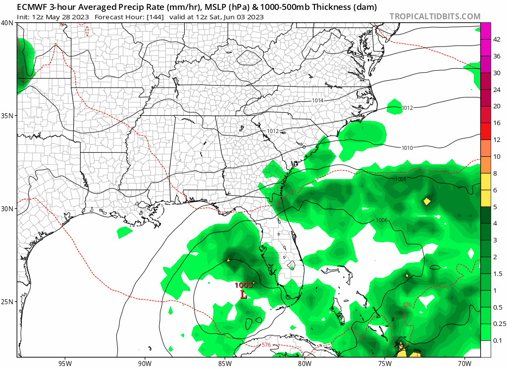
Re: 2023 Global Model Runs Discussion (Out thru day 16)
This is for Saturday June 3rd. ICON has this but the main models don't.

1 likes
Visit the Caribbean-Central America Weather Thread where you can find at first post web cams,radars
and observations from Caribbean basin members Click Here
and observations from Caribbean basin members Click Here
-
JetFuel_SE

- Category 1

- Posts: 288
- Age: 26
- Joined: Thu Apr 30, 2020 3:57 pm
Re: 2023 Global Model Runs Discussion (Out thru day 16)
cycloneye wrote:The new model HAFS will replace HMON and HWRF starting in 2025 but this 2023 season will run in parallel with those two.
https://research.noaa.gov/article/ArtMI ... ad-modelerWe are at the starting point of the next generation of hurricane forecast modeling.The initial operational capability is expected to replace the Hurricane Weather Research and Forecast System (HWRF) and the Hurricane in a Multi-scale Ocean-coupled Non-hydrostatic Model (HMON). Running the experimental version of HAFS from 2019 to 2022 in near real time, we have already seen a 10-15% improvement in track predictions compared to the best hurricane model today, HWRF. This season, these two older models will also run in parallel with HAFS as we complete the full transition.
NOAA Atlantic Oceanographic & Meteorological Laboratory, hurricane modeling team
NOAA ATLANTIC OCEANOGRAPHIC & METEOROLOGICAL LABORATORY, HURRICANE MODELING TEAM
From left: Xuejin Zhang, Russell St. Fleur, Jun Zhang, Robert Black, Gus Alaka, Lew Gramer, Andy Hazelton, William Barry, Sundararaman (Gopal) Gopalakrishnan, Mu-Chieh (Laura) Ko, Hua Leighton, William Ramstrom. Credit: NOAA
NOAA plans to implement the basin-scale HAFS in 2025 and 2026, which is expected to improve prediction of interactions between several tropical cyclones as well as the prediction of how storms behave once they make landfall. This will aid forecasters at NHC with improved products of winds, rainfall and tornado threats inland. NOAA’s Hurricane Forecast Improvement Program is also supporting the development of the HAFS ensemble system with a focus on incorporating risk communication research to create more effective watch and warning products in future.
https://twitter.com/NOAA_AOML/status/1662168470396760065
Damn, didn't think it'd become operational so soon.
0 likes

Re: 2023 Global Model Runs Discussion (Out thru day 16)
This morning's CMC also showing a 998mb low just east of the Bahamas at the same forecast time frame as well. In fact, EURO has been hinting at disturbed weather and lower pressures for the NW Caribbean and SE GOM with 1002/1003 mb over S. Florida for the same period as well. Kinda looks like an upwelling of E. Pacific moisture in tandem with an eastward migrating mid-level disturbance dropping into the GOM from Texas. Doesn't seem as if the fairly stout mean deep layer Southwesterly flow will allow much time for vertical development to occur. CMC seems to depict a deeper (998mb) further east "go with the flow" departing gift solution east of the Bahamas. Of course that model is always coming up with little "GEM's".
1 likes
Andy D
(For official information, please refer to the NHC and NWS products.)
(For official information, please refer to the NHC and NWS products.)
-
cycloneye
- Admin
- Posts: 149686
- Age: 69
- Joined: Thu Oct 10, 2002 10:54 am
- Location: San Juan, Puerto Rico
Re: 2023 Global Model Runs Discussion (Out thru day 16)
0 likes
Visit the Caribbean-Central America Weather Thread where you can find at first post web cams,radars
and observations from Caribbean basin members Click Here
and observations from Caribbean basin members Click Here

-
Sciencerocks
- Category 5
- Posts: 10189
- Age: 40
- Joined: Thu Jul 06, 2017 1:51 am
Re: 2023 Global Model Runs Discussion (Out thru day 16)
A fay 2008 like track and which will hold this thing down big time as it will be mostly inland. It is possible for an upgrade inland but it is rare. We'll see how this evolves as I'd like to see it develop further west which has been hinted at from other models like ukmet, icon and some runs of the gfs, etc. I think it is probably more likely to develop 100-200 miles west and spend far more time over the gulf which could allow for it to be named.
0 likes
-
cycloneye
- Admin
- Posts: 149686
- Age: 69
- Joined: Thu Oct 10, 2002 10:54 am
- Location: San Juan, Puerto Rico
Re: 2023 Global Model Runs Discussion (Out thru day 16)
GFS is on board now but it does not begin in GOM.

.
.
0 likes
Visit the Caribbean-Central America Weather Thread where you can find at first post web cams,radars
and observations from Caribbean basin members Click Here
and observations from Caribbean basin members Click Here
Who is online
Users browsing this forum: No registered users and 234 guests