

WPAC: MAWAR - Post-Tropical
Moderator: S2k Moderators
Re: WPAC: MAWAR - Typhoon: 12z Best Track=170 mph
06z
0 likes
ヤンデレ女が寝取られるているのを見たい!!!
ECMWF ensemble NWPAC plots: https://ecmwfensnwpac.imgbb.com/
Multimodel NWPAC plots: https://multimodelnwpac.imgbb.com/
GFS Ensemble NWPAC plots (16 & 35 day forecast): https://gefsnwpac.imgbb.com/
Plots updated automatically
ECMWF ensemble NWPAC plots: https://ecmwfensnwpac.imgbb.com/
Multimodel NWPAC plots: https://multimodelnwpac.imgbb.com/
GFS Ensemble NWPAC plots (16 & 35 day forecast): https://gefsnwpac.imgbb.com/
Plots updated automatically
-
Iceresistance

- Category 5

- Posts: 9606
- Age: 22
- Joined: Sat Oct 10, 2020 9:45 am
- Location: Tecumseh, OK/Norman, OK
Re: WPAC: MAWAR - Typhoon: 12z Best Track=170 mph

5 likes
Bill 2015 & Beta 2020
Winter 2020-2021
All observations are in Tecumseh, OK unless otherwise noted.
Winter posts are focused mainly for Oklahoma & Texas.
Take any of my forecasts with a grain of salt, refer to the NWS, SPC, and NHC for official information
Never say Never with weather! Because ANYTHING is possible!
Winter 2020-2021
All observations are in Tecumseh, OK unless otherwise noted.
Winter posts are focused mainly for Oklahoma & Texas.
Take any of my forecasts with a grain of salt, refer to the NWS, SPC, and NHC for official information
Never say Never with weather! Because ANYTHING is possible!
-
Kingarabian

- S2K Supporter

- Posts: 16378
- Joined: Sat Aug 08, 2009 3:06 am
- Location: Honolulu, Hawaii
-
cycloneye

- Admin

- Posts: 149706
- Age: 69
- Joined: Thu Oct 10, 2002 10:54 am
- Location: San Juan, Puerto Rico
Re: WPAC: MAWAR - Typhoon
0 likes
Visit the Caribbean-Central America Weather Thread where you can find at first post web cams,radars
and observations from Caribbean basin members Click Here
and observations from Caribbean basin members Click Here

Re: WPAC: MAWAR - Typhoon
cycloneye wrote:https://twitter.com/philklotzbach/status/1661740891307126785
that should read GUST 175mph i suppose.
0 likes
-
ElectricStorm

- Category 5
- Posts: 5154
- Age: 25
- Joined: Tue Aug 13, 2019 11:23 pm
- Location: Norman, OK
Re: WPAC: MAWAR - Typhoon
R o x wrote:cycloneye wrote:https://twitter.com/philklotzbach/status/1661740891307126785
that should read GUST 175mph i suppose.
No 150kts is 175mph sustained, JTWC has gusts to 180kts which is around 205mph
0 likes
B.S Meteorology, University of Oklahoma '25
Please refer to the NHC, NWS, or SPC for official information.
Please refer to the NHC, NWS, or SPC for official information.
-
DorkyMcDorkface

- Category 5
- Posts: 1042
- Age: 28
- Joined: Mon Sep 30, 2019 1:32 pm
- Location: Mid-Atlantic
Re: WPAC: MAWAR - Typhoon: 12z Best Track=170 mph
Iceresistance wrote:Holy crap, that thing is a monster!
https://s12.gifyu.com/images/47654555.gif
https://s12.gifyu.com/images/47654555.gif
Happy this entered a weakening spell as it approached and impacted Guam before it really blossomed, although impacts were still extensive regardless. Now is the perfect time for it to be a powerful, photogenic cyclone, as it isn't near any major land areas for the time being. Hopefully it does end up missing Taiwan like much of the guidance is suggesting.
0 likes
Please note the thoughts expressed by this account are solely those of the user and are from a hobbyist perspective. For more comprehensive analysis, consult an actual professional meteorologist or meteorological agency.
Floyd 1999 | Isabel 2003 | Hanna 2008 | Irene 2011 | Sandy 2012 | Isaias 2020
-
mrbagyo

- Category 5
- Posts: 3997
- Age: 33
- Joined: Thu Apr 12, 2012 9:18 am
- Location: 14.13N 120.98E
- Contact:
Re: WPAC: MAWAR - Typhoon
Sentinel-2 satellite captured the edge of Typhoon Mawar's eye earlier this morning


6 likes
The posts in this forum are NOT official forecast and should not be used as such. They are just the opinion of the poster and may or may not be backed by sound meteorological data. They are NOT endorsed by any professional institution or storm2k.org. For official information, please refer to RSMC, NHC and NWS products.
-
Iceresistance
- Category 5
- Posts: 9606
- Age: 22
- Joined: Sat Oct 10, 2020 9:45 am
- Location: Tecumseh, OK/Norman, OK
Re: WPAC: MAWAR - Typhoon
R o x wrote:ElectricStorm wrote:R o x wrote:
that should read GUST 175mph i suppose.
No 150kts is 175mph sustained, JTWC has gusts to 180kts which is around 205mph
is it really ? that is a world record right ?
Yes, but the world record is from 2015 with Patricia, 215 mph SUSTAINED winds!
It looks like it's been a while since you've been here, welcome back.
1 likes
Bill 2015 & Beta 2020
Winter 2020-2021
All observations are in Tecumseh, OK unless otherwise noted.
Winter posts are focused mainly for Oklahoma & Texas.
Take any of my forecasts with a grain of salt, refer to the NWS, SPC, and NHC for official information
Never say Never with weather! Because ANYTHING is possible!
Winter 2020-2021
All observations are in Tecumseh, OK unless otherwise noted.
Winter posts are focused mainly for Oklahoma & Texas.
Take any of my forecasts with a grain of salt, refer to the NWS, SPC, and NHC for official information
Never say Never with weather! Because ANYTHING is possible!
-
mrbagyo
- Category 5
- Posts: 3997
- Age: 33
- Joined: Thu Apr 12, 2012 9:18 am
- Location: 14.13N 120.98E
- Contact:
Re: WPAC: MAWAR - Typhoon
TERRA (EOS AM-1)

NOAA 20

NOAA 20
7 likes
The posts in this forum are NOT official forecast and should not be used as such. They are just the opinion of the poster and may or may not be backed by sound meteorological data. They are NOT endorsed by any professional institution or storm2k.org. For official information, please refer to RSMC, NHC and NWS products.
-
Hurricane2022

- Category 5
- Posts: 2092
- Joined: Tue Aug 23, 2022 11:38 pm
- Location: Araçatuba, Brazil
Re: WPAC: MAWAR - Typhoon
https://twitter.com/Carl225126302/status/1661752588323246080
FORECAST DISCUSSION: STY 02W HAS CONTINUED TO STRENGTHEN WITH STRONG RADIAL OUTFLOW AND POTENTIAL FOR FURTHER INTENSIFICATION LIKELY OVER THE NEXT DAY AS THE SYSTEM TRACKS WESTWARD. THE SYSTEM IS EXPECTED TO PEAK NEAR 155 KNOTS BUT COULD EASILY GO HIGHER. HOWEVER, THE SYSTEM SHOULD MAINTAIN SUPER TYPHOON INTENSITY OVER THE NEXT TWO DAYS UNDER HIGHLY FAVORABLE CONDITIONS WITH SLIGHT WEAKENING BY TAU 72. STY 02W WILL TRACK WEST-NORTHWESTWARD THROUGH TAU 72 UNDER THE STEERING INFLUENCE OF THE STR POSITIONED TO THE NORTH. AFTER TAU 72, STY 02W WILL TURN GRADUALLY NORTHWESTWARD TOWARD TAIWAN AND WILL SLOW AS IT ENTERS A COMPETING STEERING ENVIRONMENT BETWEEN A STR TO THE WEST, OVER SOUTHEAST CHINA, AND A STR TO THE EAST. AFTER TAU 72, THE SYSTEM WILL LIKELY WEAKEN DUE TO INCREASING VERTICAL WIND SHEAR, WEAKER DIVERGENCE ALOFT AND POSSIBLY COOL UPWELLING WATER AND SOME LIMITED DRY AIR ENTRAINMENT.
5 likes
Sorry for the bad English sometimes...!
For reliable and detailed information for any meteorological phenomenon, please consult the National Hurricane Center, Joint Typhoon Warning Center , or your local Meteo Center.
--------
ECCE OMNIA NOVA FACIAM (Ap 21,5).
For reliable and detailed information for any meteorological phenomenon, please consult the National Hurricane Center, Joint Typhoon Warning Center , or your local Meteo Center.
--------
ECCE OMNIA NOVA FACIAM (Ap 21,5).
-
Iceresistance
- Category 5
- Posts: 9606
- Age: 22
- Joined: Sat Oct 10, 2020 9:45 am
- Location: Tecumseh, OK/Norman, OK
Re: WPAC: MAWAR - Typhoon
Hurricane2022 wrote:https://twitter.com/Carl225126302/status/1661752588323246080?t=_rybScAzPpBt5ZsqFMeSXQ&s=19FORECAST DISCUSSION: STY 02W HAS CONTINUED TO STRENGTHEN WITH STRONG RADIAL OUTFLOW AND POTENTIAL FOR FURTHER INTENSIFICATION LIKELY OVER THE NEXT DAY AS THE SYSTEM TRACKS WESTWARD. THE SYSTEM IS EXPECTED TO PEAK NEAR 155 KNOTS BUT COULD EASILY GO HIGHER. HOWEVER, THE SYSTEM SHOULD MAINTAIN SUPER TYPHOON INTENSITY OVER THE NEXT TWO DAYS UNDER HIGHLY FAVORABLE CONDITIONS WITH SLIGHT WEAKENING BY TAU 72. STY 02W WILL TRACK WEST-NORTHWESTWARD THROUGH TAU 72 UNDER THE STEERING INFLUENCE OF THE STR POSITIONED TO THE NORTH. AFTER TAU 72, STY 02W WILL TURN GRADUALLY NORTHWESTWARD TOWARD TAIWAN AND WILL SLOW AS IT ENTERS A COMPETING STEERING ENVIRONMENT BETWEEN A STR TO THE WEST, OVER SOUTHEAST CHINA, AND A STR TO THE EAST. AFTER TAU 72, THE SYSTEM WILL LIKELY WEAKEN DUE TO INCREASING VERTICAL WIND SHEAR, WEAKER DIVERGENCE ALOFT AND POSSIBLY COOL UPWELLING WATER AND SOME LIMITED DRY AIR ENTRAINMENT.
Very strong wording from the JTWC, holy moly.
0 likes
Bill 2015 & Beta 2020
Winter 2020-2021
All observations are in Tecumseh, OK unless otherwise noted.
Winter posts are focused mainly for Oklahoma & Texas.
Take any of my forecasts with a grain of salt, refer to the NWS, SPC, and NHC for official information
Never say Never with weather! Because ANYTHING is possible!
Winter 2020-2021
All observations are in Tecumseh, OK unless otherwise noted.
Winter posts are focused mainly for Oklahoma & Texas.
Take any of my forecasts with a grain of salt, refer to the NWS, SPC, and NHC for official information
Never say Never with weather! Because ANYTHING is possible!
-
Sciencerocks
- Category 5
- Posts: 10193
- Age: 40
- Joined: Thu Jul 06, 2017 1:51 am
-
cycloneye
- Admin
- Posts: 149706
- Age: 69
- Joined: Thu Oct 10, 2002 10:54 am
- Location: San Juan, Puerto Rico
Re: WPAC: MAWAR - Typhoon
0 likes
Visit the Caribbean-Central America Weather Thread where you can find at first post web cams,radars
and observations from Caribbean basin members Click Here
and observations from Caribbean basin members Click Here
-
Hurricane2022
- Category 5
- Posts: 2092
- Joined: Tue Aug 23, 2022 11:38 pm
- Location: Araçatuba, Brazil
Re: WPAC: MAWAR - Typhoon
6 likes
Sorry for the bad English sometimes...!
For reliable and detailed information for any meteorological phenomenon, please consult the National Hurricane Center, Joint Typhoon Warning Center , or your local Meteo Center.
--------
ECCE OMNIA NOVA FACIAM (Ap 21,5).
For reliable and detailed information for any meteorological phenomenon, please consult the National Hurricane Center, Joint Typhoon Warning Center , or your local Meteo Center.
--------
ECCE OMNIA NOVA FACIAM (Ap 21,5).
-
cheezyWXguy

- Category 5
- Posts: 6282
- Joined: Mon Feb 13, 2006 12:29 am
- Location: Dallas, TX
Re: WPAC: MAWAR - Typhoon
That storm’s structure is built like a brick house. Wouldn’t expect any ERCs for a while
1 likes
-
cycloneye
- Admin
- Posts: 149706
- Age: 69
- Joined: Thu Oct 10, 2002 10:54 am
- Location: San Juan, Puerto Rico
Re: WPAC: MAWAR - Typhoon
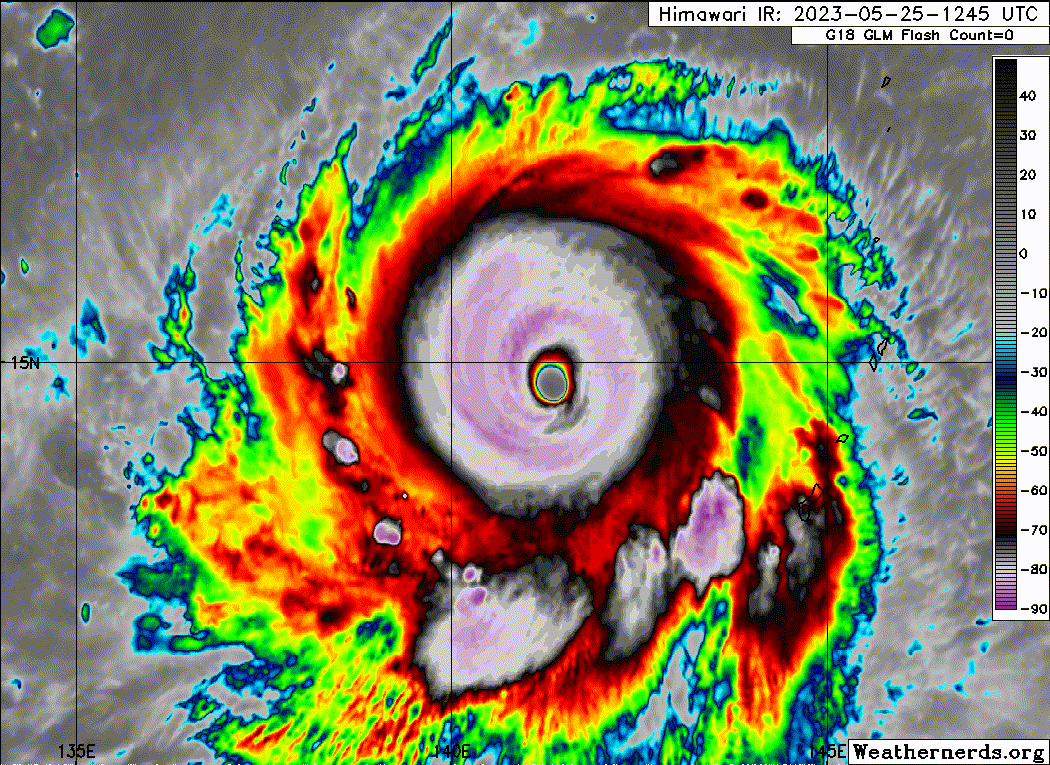
Up to 155kt.
WP, 02, 2023052518, , BEST, 0, 149N, 1405E, 155, 903, ST
4 likes
Visit the Caribbean-Central America Weather Thread where you can find at first post web cams,radars
and observations from Caribbean basin members Click Here
and observations from Caribbean basin members Click Here
-
Hurricane2022
- Category 5
- Posts: 2092
- Joined: Tue Aug 23, 2022 11:38 pm
- Location: Araçatuba, Brazil
Re: WPAC: MAWAR - Typhoon: 18z Best Track up to 155kt / 903 mbs
4 likes
Sorry for the bad English sometimes...!
For reliable and detailed information for any meteorological phenomenon, please consult the National Hurricane Center, Joint Typhoon Warning Center , or your local Meteo Center.
--------
ECCE OMNIA NOVA FACIAM (Ap 21,5).
For reliable and detailed information for any meteorological phenomenon, please consult the National Hurricane Center, Joint Typhoon Warning Center , or your local Meteo Center.
--------
ECCE OMNIA NOVA FACIAM (Ap 21,5).
-
Hurricane2022
- Category 5
- Posts: 2092
- Joined: Tue Aug 23, 2022 11:38 pm
- Location: Araçatuba, Brazil
Re: WPAC: MAWAR - Typhoon: 18z Best Track up to 155kt / 903 mbs
02W MAWAR 230525 1200 14.7N 141.6E WPAC 150 908
02W MAWAR 230525 0600 14.5N 142.8E WPAC 145 913
02W MAWAR 230525 0600 14.5N 142.8E WPAC 145 913
0 likes
Sorry for the bad English sometimes...!
For reliable and detailed information for any meteorological phenomenon, please consult the National Hurricane Center, Joint Typhoon Warning Center , or your local Meteo Center.
--------
ECCE OMNIA NOVA FACIAM (Ap 21,5).
For reliable and detailed information for any meteorological phenomenon, please consult the National Hurricane Center, Joint Typhoon Warning Center , or your local Meteo Center.
--------
ECCE OMNIA NOVA FACIAM (Ap 21,5).
-
SconnieCane
- Category 5
- Posts: 1013
- Joined: Thu Aug 02, 2018 5:29 pm
- Location: Madison, WI
Re: WPAC: MAWAR - Typhoon: 18z Best Track up to 155kt / 903 mbs
What a beaut.
I'm watching Mawar with some interest for downstream impacts to the jet stream after it recurves into the westerlies; kinda hoping it helps shake up the pattern over the central US which has been very stagnant and quiescent since about mid-April. Very little in the way of thunderstorm and tornado activity, when May is supposed to be for land-based storm chasing what September is to the Atlantic hurricane season.
I'm watching Mawar with some interest for downstream impacts to the jet stream after it recurves into the westerlies; kinda hoping it helps shake up the pattern over the central US which has been very stagnant and quiescent since about mid-April. Very little in the way of thunderstorm and tornado activity, when May is supposed to be for land-based storm chasing what September is to the Atlantic hurricane season.
0 likes
Who is online
Users browsing this forum: No registered users and 62 guests