https://twitter.com/wx_tiger/status/1664279787706413062
ATL: ARLENE - Post-Tropical
Moderator: S2k Moderators
-
cycloneye

- Admin

- Posts: 149275
- Age: 69
- Joined: Thu Oct 10, 2002 10:54 am
- Location: San Juan, Puerto Rico
Re: ATL: INVEST 91L - Discussion
1 likes
Visit the Caribbean-Central America Weather Thread where you can find at first post web cams,radars
and observations from Caribbean basin members Click Here
and observations from Caribbean basin members Click Here

Re: ATL: INVEST 91L - Discussion
Fairly stout 500 mb heights over South Texas and N. Mexico appear to be preventing any further northward motion in an otherwise flat (or weak) steering flow. Looks like a trough or cut-off low off Nova Scotia will begin to drop southwest and deepen in about 72-96 hours resulting in a northeast motion around that time.
0 likes
Andy D
(For official information, please refer to the NHC and NWS products.)
(For official information, please refer to the NHC and NWS products.)
Re: ATL: INVEST 91L - Discussion
Overall i'd say this disturbance has relatively consolidated appearance. I personally think NHC will call off any recon for today but If convection is able to persist and a clear LLC becomes apparent then we'll see a recon flight tomm. and would then expect likely upgrade to TD perhaps tomorrow morning or afternoon. I dont think we quite have a closed LLC at the surface yet, but it sure is trying. I doubt that an authentic T.S. will develop given upper level conditions (but that rarely stopped NHC from pulling the trigger from numerous other past questionable GOM upgrades LOL). Maybe a "Potential Storm Watch" for Florida Southwest coast & S. Fla for Saturday/Sunday??
0 likes
Andy D
(For official information, please refer to the NHC and NWS products.)
(For official information, please refer to the NHC and NWS products.)
-
wxman57

- Moderator-Pro Met

- Posts: 23172
- Age: 68
- Joined: Sat Jun 21, 2003 8:06 pm
- Location: Houston, TX (southwest)
Re: ATL: INVEST 91L - Discussion
Looks like it will peak within the next 12 hours or so as it tracks slowly southward. Will likely dissipate near western Cuba on Saturday. No Florida threat.
0 likes

Re: ATL: INVEST 91L - Discussion
There is a frontal boundary that has dug way south with heavy shear ahead of it across Cuba.
Front missed so now we have the steering from the north on the back side of the front.
Front missed so now we have the steering from the north on the back side of the front.
0 likes

Re: ATL: INVEST 91L - Discussion
wxman57 wrote:Looks like it will peak within the next 12 hours or so as it tracks slowly southward. Will likely dissipate near western Cuba on Saturday. No Florida threat.
What about rain out of this,do you see that being a concern.
0 likes
-
wxman57
- Moderator-Pro Met
- Posts: 23172
- Age: 68
- Joined: Sat Jun 21, 2003 8:06 pm
- Location: Houston, TX (southwest)
Re: ATL: INVEST 91L - Discussion
boca wrote:wxman57 wrote:Looks like it will peak within the next 12 hours or so as it tracks slowly southward. Will likely dissipate near western Cuba on Saturday. No Florida threat.
What about rain out of this,do you see that being a concern.
Not much rain for Florida, as it is very small and not moving any closer to Florida. Wind shear will cause squalls east of the center to gradually decline.
0 likes
-
tropicwatch

- Category 5

- Posts: 3426
- Age: 62
- Joined: Sat Jun 02, 2007 10:01 am
- Location: Panama City Florida
- Contact:
Re: ATL: INVEST 91L - Discussion
boca wrote:wxman57 wrote:Looks like it will peak within the next 12 hours or so as it tracks slowly southward. Will likely dissipate near western Cuba on Saturday. No Florida threat.
What about rain out of this,do you see that being a concern.
0 likes
Tropicwatch
Agnes 72', Eloise 75, Elena 85', Kate 85', Charley 86', Florence 88', Beryl 94', Dean 95', Erin 95', Opal 95', Earl 98', Georges 98', Ivan 2004', Arlene 2005', Dennis 2005', Ida 2009' Debby 2012' Irma 2017' Michael 2018'
Agnes 72', Eloise 75, Elena 85', Kate 85', Charley 86', Florence 88', Beryl 94', Dean 95', Erin 95', Opal 95', Earl 98', Georges 98', Ivan 2004', Arlene 2005', Dennis 2005', Ida 2009' Debby 2012' Irma 2017' Michael 2018'
-
Aric Dunn
- Category 5
- Posts: 21238
- Age: 43
- Joined: Sun Sep 19, 2004 9:58 pm
- Location: Ready for the Chase.
- Contact:
Re: ATL: INVEST 91L - Discussion
I seriously hope none of you are debating if this is a TD/TS already ( has been) or not.......
3 likes
Note: If I make a post that is brief. Please refer back to previous posts for the analysis or reasoning. I do not re-write/qoute what my initial post said each time.
If there is nothing before... then just ask
Space & Atmospheric Physicist, Embry-Riddle Aeronautical University,
I believe the sky is falling...
If there is nothing before... then just ask
Space & Atmospheric Physicist, Embry-Riddle Aeronautical University,
I believe the sky is falling...
-
Sciencerocks
- Category 5
- Posts: 10181
- Age: 40
- Joined: Thu Jul 06, 2017 1:51 am

Re: ATL: INVEST 91L - Discussion
ronjon wrote:If the LLC is tucked under the deep convection I believe we have TD 1. Banding features, deep convection, and pressure down to 1007 mb would meet the criteria.
Technically TD 2, but it will be TS Arlene if it gets 35 kt winds. The number 1 is used for the unnamed subtropical storm in January.
0 likes
TC naming lists: retirements and intensity
Most aggressive Advisory #1's in North Atlantic (cr. kevin for starting the list)
Most aggressive Advisory #1's in North Atlantic (cr. kevin for starting the list)
-
cycloneye
- Admin
- Posts: 149275
- Age: 69
- Joined: Thu Oct 10, 2002 10:54 am
- Location: San Juan, Puerto Rico
Re: ATL: INVEST 91L - Discussion
Teban54 wrote:ronjon wrote:If the LLC is tucked under the deep convection I believe we have TD 1. Banding features, deep convection, and pressure down to 1007 mb would meet the criteria.
Technically TD 2, but it will be TS Arlene if it gets 35 kt winds. The number 1 is used for the unnamed subtropical storm in January.
Recon will find out this afternoon, what we have.
0 likes
Visit the Caribbean-Central America Weather Thread where you can find at first post web cams,radars
and observations from Caribbean basin members Click Here
and observations from Caribbean basin members Click Here
-
cycloneye
- Admin
- Posts: 149275
- Age: 69
- Joined: Thu Oct 10, 2002 10:54 am
- Location: San Juan, Puerto Rico
Re: ATL: INVEST 91L - Discussion

2 likes
Visit the Caribbean-Central America Weather Thread where you can find at first post web cams,radars
and observations from Caribbean basin members Click Here
and observations from Caribbean basin members Click Here
-
Sciencerocks
- Category 5
- Posts: 10181
- Age: 40
- Joined: Thu Jul 06, 2017 1:51 am
Re: ATL: INVEST 91L - Discussion
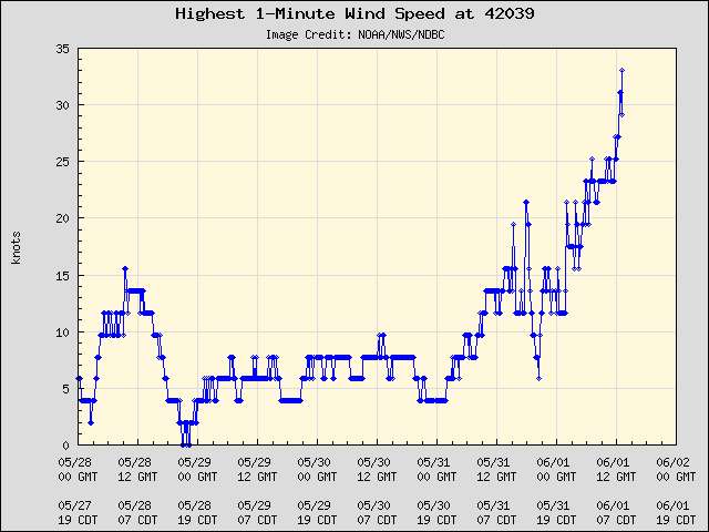
Based on the ascat I'd argue depression. This will probably become Arlene in the next 24 hours...
0 likes
-
Sciencerocks
- Category 5
- Posts: 10181
- Age: 40
- Joined: Thu Jul 06, 2017 1:51 am
-
AtlanticWind

- S2K Supporter

- Posts: 1898
- Age: 67
- Joined: Sun Aug 08, 2004 9:57 pm
- Location: Plantation,Fla
Re: ATL: INVEST 91L - Discussion
wxman57 wrote:boca wrote:wxman57 wrote:Looks like it will peak within the next 12 hours or so as it tracks slowly southward. Will likely dissipate near western Cuba on Saturday. No Florida threat.
What about rain out of this,do you see that being a concern.
Not much rain for Florida, as it is very small and not moving any closer to Florida. Wind shear will cause squalls east of the center to gradually decline.
South Florida under flood watch, NWS discussion talks about this upper low and 91L
continuing to pump moisture into the area thru Saturday with heavy rain expected to continue.
0 likes
-
CrazyC83
- Professional-Met

- Posts: 34315
- Joined: Tue Mar 07, 2006 11:57 pm
- Location: Deep South, for the first time!
Re: ATL: INVEST 91L - Discussion
One thing is for sure, this is a very unusual track, due south in the Gulf of Mexico. The building ridge is definitely helping out there.
1 likes
-
cycloneye
- Admin
- Posts: 149275
- Age: 69
- Joined: Thu Oct 10, 2002 10:54 am
- Location: San Juan, Puerto Rico
Re: ATL: INVEST 91L - Discussion
70%
Tropical Weather Outlook
NWS National Hurricane Center Miami FL
200 PM EDT Thu Jun 1 2023
For the North Atlantic...Caribbean Sea and the Gulf of Mexico:
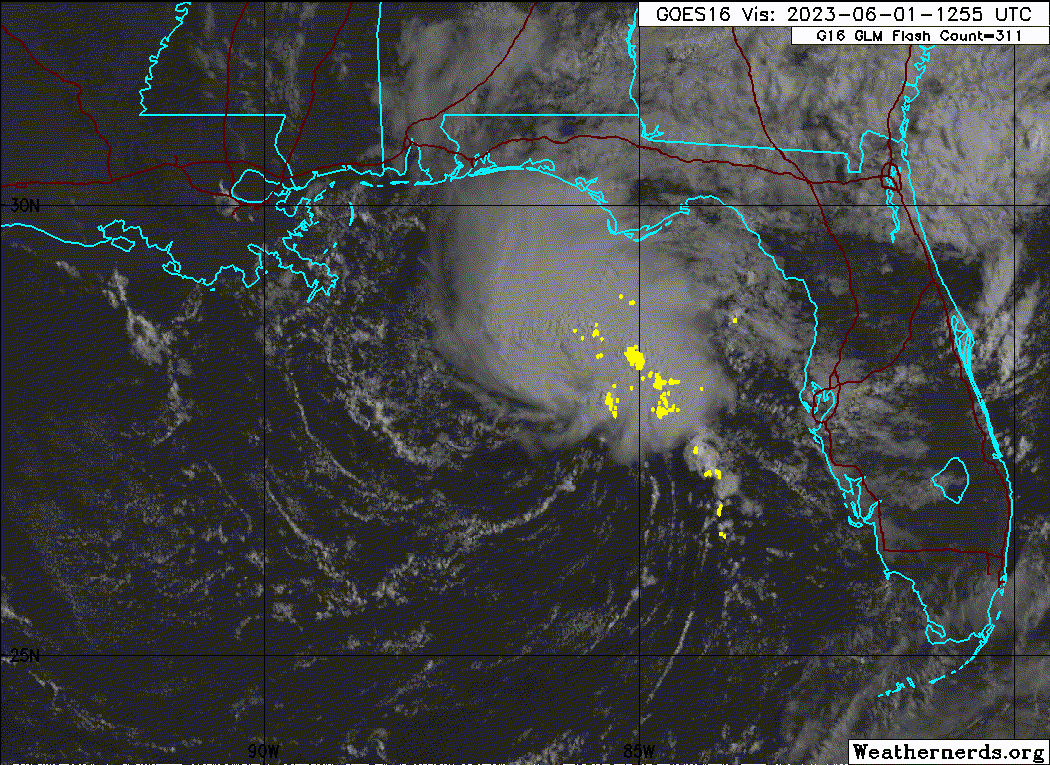
1. Northeastern Gulf of Mexico (AL91):
Recent satellite wind data, along with buoy and ship observations
indicate the area of low pressure over the northeastern Gulf of
Mexico has a broad but well-defined circulation with maximum
sustained winds of about 35 mph. Shower and thunderstorm activity
associated with the low is also showing signs of organization.
Environmental conditions remain marginally favorable for additional
development, and if these trends continue, a short-lived tropical
depression or storm is likely to form as soon as this afternoon. The
system is likely to meander over the northeastern Gulf of Mexico
through tonight but begin a slow southward motion on Friday. By
this weekend, environmental conditions are forecast to become
unfavorable for additional development as the system continues
moving southward, likely remaining offshore over the Gulf of Mexico.
An Air Force Reserve Hurricane Hunter aircraft is scheduled to
investigate the system later this afternoon.
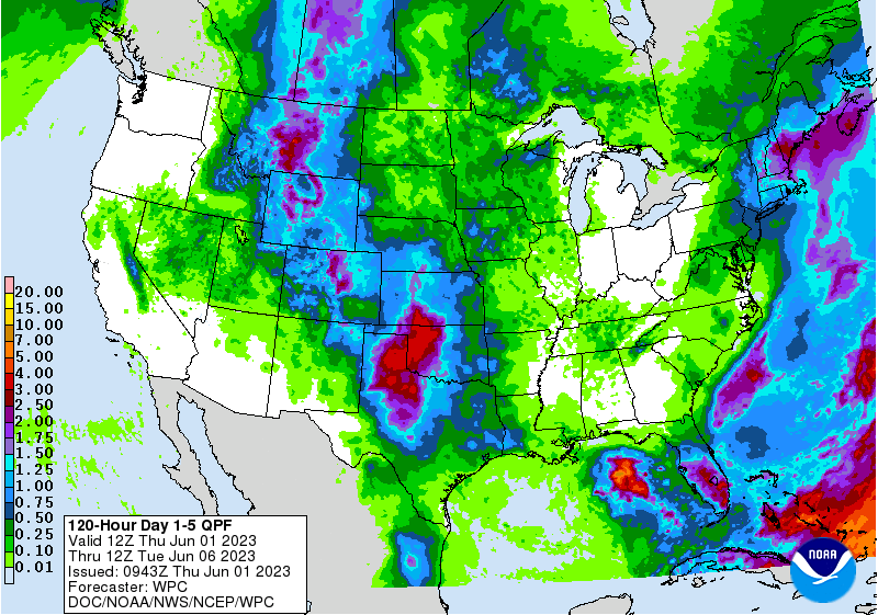
Regardless of development, locally heavy rainfall could occur over
portions of the Florida Peninsula through this weekend. Additional
information on the rainfall and flooding potential can be found in
products issued by your local National Weather Service forecast
office and Excessive Rainfall Outlooks issued by the Weather
Prediction Center.
* Formation chance through 48 hours...high...70 percent.
* Formation chance through 7 days...high...70 percent.
Forecaster Papin/Cangialosi
NWS National Hurricane Center Miami FL
200 PM EDT Thu Jun 1 2023
For the North Atlantic...Caribbean Sea and the Gulf of Mexico:
1. Northeastern Gulf of Mexico (AL91):
Recent satellite wind data, along with buoy and ship observations
indicate the area of low pressure over the northeastern Gulf of
Mexico has a broad but well-defined circulation with maximum
sustained winds of about 35 mph. Shower and thunderstorm activity
associated with the low is also showing signs of organization.
Environmental conditions remain marginally favorable for additional
development, and if these trends continue, a short-lived tropical
depression or storm is likely to form as soon as this afternoon. The
system is likely to meander over the northeastern Gulf of Mexico
through tonight but begin a slow southward motion on Friday. By
this weekend, environmental conditions are forecast to become
unfavorable for additional development as the system continues
moving southward, likely remaining offshore over the Gulf of Mexico.
An Air Force Reserve Hurricane Hunter aircraft is scheduled to
investigate the system later this afternoon.
Regardless of development, locally heavy rainfall could occur over
portions of the Florida Peninsula through this weekend. Additional
information on the rainfall and flooding potential can be found in
products issued by your local National Weather Service forecast
office and Excessive Rainfall Outlooks issued by the Weather
Prediction Center.
* Formation chance through 48 hours...high...70 percent.
* Formation chance through 7 days...high...70 percent.
Forecaster Papin/Cangialosi
1 likes
Visit the Caribbean-Central America Weather Thread where you can find at first post web cams,radars
and observations from Caribbean basin members Click Here
and observations from Caribbean basin members Click Here
-
MarioProtVI
- Category 5
- Posts: 1034
- Age: 24
- Joined: Sun Sep 29, 2019 7:33 pm
- Location: New Jersey
Re: ATL: INVEST 91L - Discussion
Props to the mesoscales for absolutely nailing this. Most of the other models didn’t even as such develop a closed low from this system.
2 likes
Re: ATL: INVEST 91L - Discussion
When recon gets there shortly they will probably find a closed circulation at about 1007 mb's.
Shear forecast and dry air over the gulf are comforting factors but I don't know if the NHC can just ignore recon data because a LLC is forecast to dissipate.
Shear forecast and dry air over the gulf are comforting factors but I don't know if the NHC can just ignore recon data because a LLC is forecast to dissipate.
1 likes
Who is online
Users browsing this forum: No registered users and 85 guests