WPAC: MAWAR - Post-Tropical
Moderator: S2k Moderators
-
wxman57

- Moderator-Pro Met

- Posts: 23175
- Age: 68
- Joined: Sat Jun 21, 2003 8:06 pm
- Location: Houston, TX (southwest)
Re: WPAC: MAWAR - Typhoon
Mawar looking less "typhoony" at present, with Dvorak numbers dropping below 4.0. Should steadily weaken as it passes east of Taiwan and the Ryukyu Islands.
0 likes
-
cycloneye

- Admin

- Posts: 149705
- Age: 69
- Joined: Thu Oct 10, 2002 10:54 am
- Location: San Juan, Puerto Rico
Re: WPAC: MAWAR - Typhoon
0 likes
Visit the Caribbean-Central America Weather Thread where you can find at first post web cams,radars
and observations from Caribbean basin members Click Here
and observations from Caribbean basin members Click Here
-
wxman57
- Moderator-Pro Met
- Posts: 23175
- Age: 68
- Joined: Sat Jun 21, 2003 8:06 pm
- Location: Houston, TX (southwest)
Re: WPAC: MAWAR - Typhoon
Dvorak is now 2.9/43 kts (CIMSS) and 3.5 NOAA. With very little moisture left of the center, Okinawa may not get much rainfall as it passes to the east.
0 likes
-
Sciencerocks
- Category 5

- Posts: 10193
- Age: 40
- Joined: Thu Jul 06, 2017 1:51 am
-
cycloneye
- Admin
- Posts: 149705
- Age: 69
- Joined: Thu Oct 10, 2002 10:54 am
- Location: San Juan, Puerto Rico
Re: WPAC: MAWAR - Tropical Storm
WP, 02, 2023053100, , BEST, 0, 215N, 1252E, 60, 977, TS
0 likes
Visit the Caribbean-Central America Weather Thread where you can find at first post web cams,radars
and observations from Caribbean basin members Click Here
and observations from Caribbean basin members Click Here
-
1900hurricane

- Category 5
- Posts: 6063
- Age: 34
- Joined: Fri Feb 06, 2015 12:04 pm
- Location: Houston, TX
- Contact:
Re: WPAC: MAWAR - Typhoon
Sciencerocks wrote:For stats purposes. Here are the top 10 tropical cyclones with the highest Accumulated Cyclone Energy (ACE) for the month of May in the Western Pacific basin since 1950.
1. #Mawar (2023) – 51.5*
2. Trix (1957) – 50.6
3. Phyllis (1958) – 47.0
4. Pamela (1976) – 43.4
5. Walt (1991) – 39.4
6. Dolphin (2015) – 30.8
7. Nida (2004) – 30.0
8. Noul (2015) – 28.1
9. Chanchu (2006) – 27.3
10. Doris (1950) – 27.0
Does Amy '71 just miss the list?
0 likes
Contract Meteorologist. TAMU & MSST. Fiercely authentic, one of a kind. We are all given free will, so choose a life meant to be lived. We are the Masters of our own Stories.
Opinions expressed are mine alone.
Follow me on Twitter at @1900hurricane : Read blogs at https://1900hurricane.wordpress.com/
Opinions expressed are mine alone.
Follow me on Twitter at @1900hurricane : Read blogs at https://1900hurricane.wordpress.com/
-
wxman57
- Moderator-Pro Met
- Posts: 23175
- Age: 68
- Joined: Sat Jun 21, 2003 8:06 pm
- Location: Houston, TX (southwest)
Re: WPAC: MAWAR - Tropical Storm
cycloneye wrote:WP, 02, 2023053100, , BEST, 0, 215N, 1252E, 60, 977, TS
That estimate doesn't agree with the official RSMC (JMA). JMA has 70 kt 10-min winds in their advisory issued at 0050Z. They are often very slow to downgrade any storm near land.
0 likes
-
1900hurricane
- Category 5
- Posts: 6063
- Age: 34
- Joined: Fri Feb 06, 2015 12:04 pm
- Location: Houston, TX
- Contact:
Re: WPAC: MAWAR - Typhoon
Latest SAR data looks closer to the JMA estimate with a 1 minute wind estimate of 72 kt. Looks like the west side is rather mild though.


1 likes
Contract Meteorologist. TAMU & MSST. Fiercely authentic, one of a kind. We are all given free will, so choose a life meant to be lived. We are the Masters of our own Stories.
Opinions expressed are mine alone.
Follow me on Twitter at @1900hurricane : Read blogs at https://1900hurricane.wordpress.com/
Opinions expressed are mine alone.
Follow me on Twitter at @1900hurricane : Read blogs at https://1900hurricane.wordpress.com/

Re: WPAC: MAWAR - Typhoon
1900hurricane wrote:Sciencerocks wrote:For stats purposes. Here are the top 10 tropical cyclones with the highest Accumulated Cyclone Energy (ACE) for the month of May in the Western Pacific basin since 1950.
1. #Mawar (2023) – 51.5*
2. Trix (1957) – 50.6
3. Phyllis (1958) – 47.0
4. Pamela (1976) – 43.4
5. Walt (1991) – 39.4
6. Dolphin (2015) – 30.8
7. Nida (2004) – 30.0
8. Noul (2015) – 28.1
9. Chanchu (2006) – 27.3
10. Doris (1950) – 27.0
Does Amy '71 just miss the list?
Amy is split into April but May ACE is 35.8725 so it should be on that list.
0 likes
-
dexterlabio
- Category 5
- Posts: 3517
- Joined: Sat Oct 24, 2009 11:50 pm
Re: WPAC: MAWAR - Typhoon
Now that Mawar is nearing its end, I think it's safe to assess that GFS nailed the forecast, both in intensity and track.
0 likes
Personal Forecast Disclaimer:
The posts in this forum are NOT official forecast and should not be used as such. They are just the opinion of the poster and may or may not be backed by sound meteorological data. They are NOT endorsed by any professional institution or storm2k.org. For official information, please refer to the NHC and NWS products.
The posts in this forum are NOT official forecast and should not be used as such. They are just the opinion of the poster and may or may not be backed by sound meteorological data. They are NOT endorsed by any professional institution or storm2k.org. For official information, please refer to the NHC and NWS products.
-
1900hurricane
- Category 5
- Posts: 6063
- Age: 34
- Joined: Fri Feb 06, 2015 12:04 pm
- Location: Houston, TX
- Contact:
Re: WPAC: MAWAR - Typhoon
Most guidance has done pretty well for Mawar, but the GFS (here in its interpolated AVNI version) was a to performer out to tau 96, on par with and even sometimes better than the multi-model consensuses. Definitely an impressive performance. In the extended taus, the European suite ended up taking the win, but those are taus that don't show up on a 5 day forecast.

3 likes
Contract Meteorologist. TAMU & MSST. Fiercely authentic, one of a kind. We are all given free will, so choose a life meant to be lived. We are the Masters of our own Stories.
Opinions expressed are mine alone.
Follow me on Twitter at @1900hurricane : Read blogs at https://1900hurricane.wordpress.com/
Opinions expressed are mine alone.
Follow me on Twitter at @1900hurricane : Read blogs at https://1900hurricane.wordpress.com/
-
TyphoonNara

- Category 1

- Posts: 369
- Age: 25
- Joined: Tue Dec 04, 2018 9:41 am
- Location: Hong Kong
Re: WPAC: MAWAR - Typhoon
Mawar is moving so slowly right now. The whole of South China is expected to suffer from extreme high heat for a few days due to sinking air associated with the storm.
0 likes
-
cycloneye
- Admin
- Posts: 149705
- Age: 69
- Joined: Thu Oct 10, 2002 10:54 am
- Location: San Juan, Puerto Rico
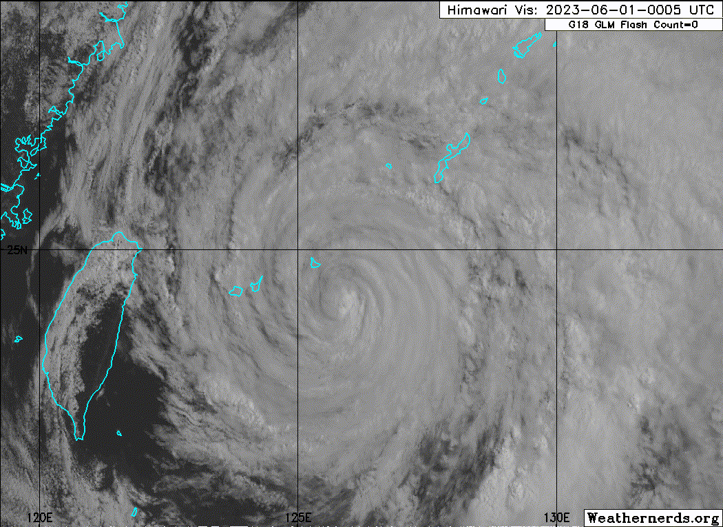
Re: WPAC: MAWAR - Severe Tropical Storm
T2302(Mawar)
Issued at 2023/05/31 18:50 UTC
Analysis at 05/31 18 UTC
Grade STS
Scale Large
Intensity -
Center position N23°25′ (23.4°)
E125°35′ (125.6°)
Direction and speed of movement NNE 10 km/h (6 kt)
Central pressure 970 hPa
Maximum sustained wind speed near center 30 m/s (60 kt)
Maximum wind gust speed 45 m/s (85 kt)
Radius of 50-kt wind area E165 km (90 NM)
W130 km (70 NM)
0 likes
Visit the Caribbean-Central America Weather Thread where you can find at first post web cams,radars
and observations from Caribbean basin members Click Here
and observations from Caribbean basin members Click Here
-
wxman57
- Moderator-Pro Met
- Posts: 23175
- Age: 68
- Joined: Sat Jun 21, 2003 8:06 pm
- Location: Houston, TX (southwest)
Re: WPAC: MAWAR - Severe Tropical Storm
It's starting to merge with the cold front now. Won't be tropical for much longer.
1 likes
-
Sciencerocks
- Category 5
- Posts: 10193
- Age: 40
- Joined: Thu Jul 06, 2017 1:51 am
-
doomhaMwx

- Category 5
- Posts: 2495
- Age: 27
- Joined: Tue Apr 18, 2017 4:01 am
- Location: Baguio/Benguet, Philippines
- Contact:
Re: WPAC: MAWAR - Severe Tropical Storm
Drifting buoy "5103534" south of Ishigakijima recorded an SLP of 963.9 mb near the eye of Typhoon Mawar on May 31, 08Z. Central pressure estimate by JTWC and JMA at that time was 975mb and 965mb, respectively.


0 likes
-
cycloneye
- Admin
- Posts: 149705
- Age: 69
- Joined: Thu Oct 10, 2002 10:54 am
- Location: San Juan, Puerto Rico
Re: WPAC: MAWAR - Severe Tropical Storm
Closest point of approach to Okinawa has passed.

02W MAWAR 230601 1800 26.4N 128.3E WPAC 50 975
0 likes
Visit the Caribbean-Central America Weather Thread where you can find at first post web cams,radars
and observations from Caribbean basin members Click Here
and observations from Caribbean basin members Click Here
-
1900hurricane
- Category 5
- Posts: 6063
- Age: 34
- Joined: Fri Feb 06, 2015 12:04 pm
- Location: Houston, TX
- Contact:
Re: WPAC: MAWAR - Severe Tropical Storm
Lowest pressue in Okinawa looks like it was 972.2 at Naha.

Highest gust I saw was 32.7 m/s at Miyagijima.

Highest gust I saw was 32.7 m/s at Miyagijima.
2 likes
Contract Meteorologist. TAMU & MSST. Fiercely authentic, one of a kind. We are all given free will, so choose a life meant to be lived. We are the Masters of our own Stories.
Opinions expressed are mine alone.
Follow me on Twitter at @1900hurricane : Read blogs at https://1900hurricane.wordpress.com/
Opinions expressed are mine alone.
Follow me on Twitter at @1900hurricane : Read blogs at https://1900hurricane.wordpress.com/
-
cycloneye
- Admin
- Posts: 149705
- Age: 69
- Joined: Thu Oct 10, 2002 10:54 am
- Location: San Juan, Puerto Rico
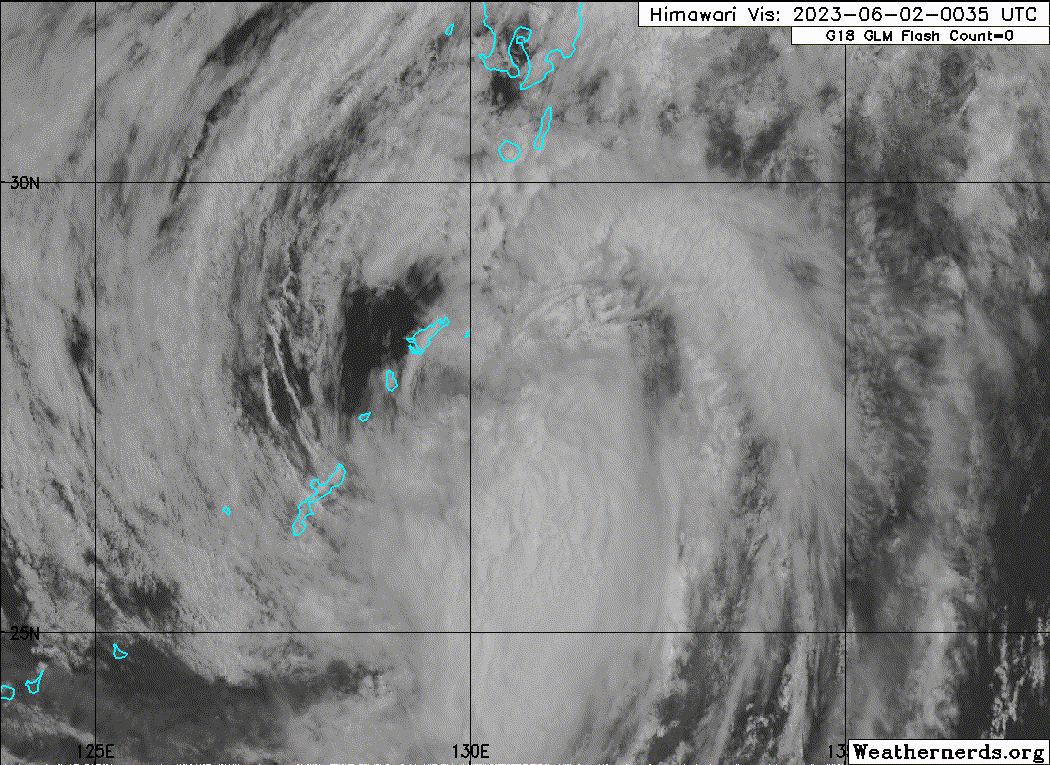
Re: WPAC: MAWAR - Tropical Storm
JMA downgrades from Severe Tropical Storm to Tropical Storm.
T2302(Mawar)
Issued at 2023/06/02 00:50 UTC
Analysis at 06/02 00 UTC
Grade TS
Scale Large
Intensity -
Center position N27°20′ (27.3°)
E129°55′ (129.9°)
Direction and speed of movement ENE 25 km/h (14 kt)
Central pressure 980 hPa
Maximum sustained wind speed near center 23 m/s (45 kt)
Maximum wind gust speed 35 m/s (65 kt)
Radius of 30-kt wind area E560 km (300 NM)
W440 km (240 NM)
0 likes
Visit the Caribbean-Central America Weather Thread where you can find at first post web cams,radars
and observations from Caribbean basin members Click Here
and observations from Caribbean basin members Click Here
-
Sciencerocks
- Category 5
- Posts: 10193
- Age: 40
- Joined: Thu Jul 06, 2017 1:51 am
Who is online
Users browsing this forum: No registered users and 81 guests