2023 Global Model Runs Discussion (Out thru day 16)
Moderator: S2k Moderators
Forum rules

The posts in this forum are NOT official forecasts and should not be used as such. They are just the opinion of the poster and may or may not be backed by sound meteorological data. They are NOT endorsed by any professional institution or STORM2K. For official information, please refer to products from the National Hurricane Center and National Weather Service.
Re: 2023 Global Model Runs Discussion (Out thru day 16)
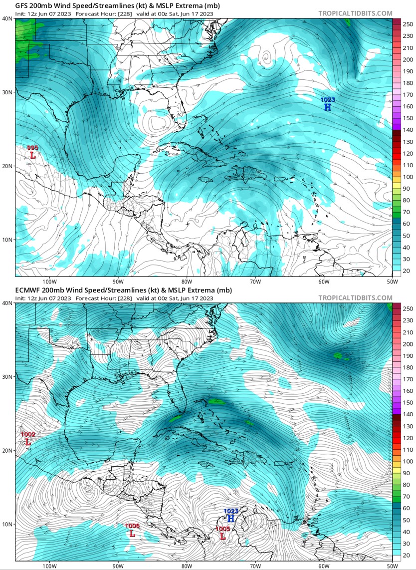
Fwiw, 12Z GFS also has a Gulf H coming up from the W Caribbean in week 2. This could still very easily be a fake, especially with the very quiet EPS for then, but nobody can possibly have any idea this far out. I count 9 GFS runs in a row with a strong WCar and/or Gulf TC for around that time, but I've seen 20-25+ runs in a row a few times for what turned out to be a fake.
2 likes
Personal Forecast Disclaimer:
The posts in this forum are NOT official forecasts and should not be used as such. They are just the opinion of the poster and may or may not be backed by sound meteorological data. They are NOT endorsed by any professional institution or storm2k.org. For official information, please refer to the NHC and NWS products.
The posts in this forum are NOT official forecasts and should not be used as such. They are just the opinion of the poster and may or may not be backed by sound meteorological data. They are NOT endorsed by any professional institution or storm2k.org. For official information, please refer to the NHC and NWS products.
-
cycloneye

- Admin

- Posts: 149697
- Age: 69
- Joined: Thu Oct 10, 2002 10:54 am
- Location: San Juan, Puerto Rico
Re: 2023 Global Model Runs Discussion (Out thru day 16)
2 likes
Visit the Caribbean-Central America Weather Thread where you can find at first post web cams,radars
and observations from Caribbean basin members Click Here
and observations from Caribbean basin members Click Here
-
wxman57

- Moderator-Pro Met

- Posts: 23175
- Age: 68
- Joined: Sat Jun 21, 2003 8:06 pm
- Location: Houston, TX (southwest)
Re: 2023 Global Model Runs Discussion (Out thru day 16)
It's within the scope of the Canadian & EC now. Canadian 12Z run has nothing at all in the NW Caribbean. Not even any vorticity at 850 mb. Let's see what the 12Z EC shows. 00Z EZ had a 500mb trof moving across Central America and into the East Pacific. Quite different from the GFS.
1 likes
-
wxman57
- Moderator-Pro Met
- Posts: 23175
- Age: 68
- Joined: Sat Jun 21, 2003 8:06 pm
- Location: Houston, TX (southwest)
Re: 2023 Global Model Runs Discussion (Out thru day 16)
After seeing Levi's tweet, above, I made a comparison between the 12Z GFS and 12Z Euro for the same time period. They couldn't be more different. Euro has no trof and high shear across the Gulf. Canadian is similar. Careful about believing the outlier model.
0 likes

Re: 2023 Global Model Runs Discussion (Out thru day 16)
wxman57 wrote:After seeing Levi's tweet, above, I made a comparison between the 12Z GFS and 12Z Euro for the same time period. They couldn't be more different. Euro has no trof and high shear across the Gulf. Canadian is similar. Careful about believing the outlier model.
http://wxman57.com/images/12ZModels.jpg
Aren’t those two from two separate days. The GFS is from today, but the euro is from yesterday.
0 likes
Re: 2023 Global Model Runs Discussion (Out thru day 16)
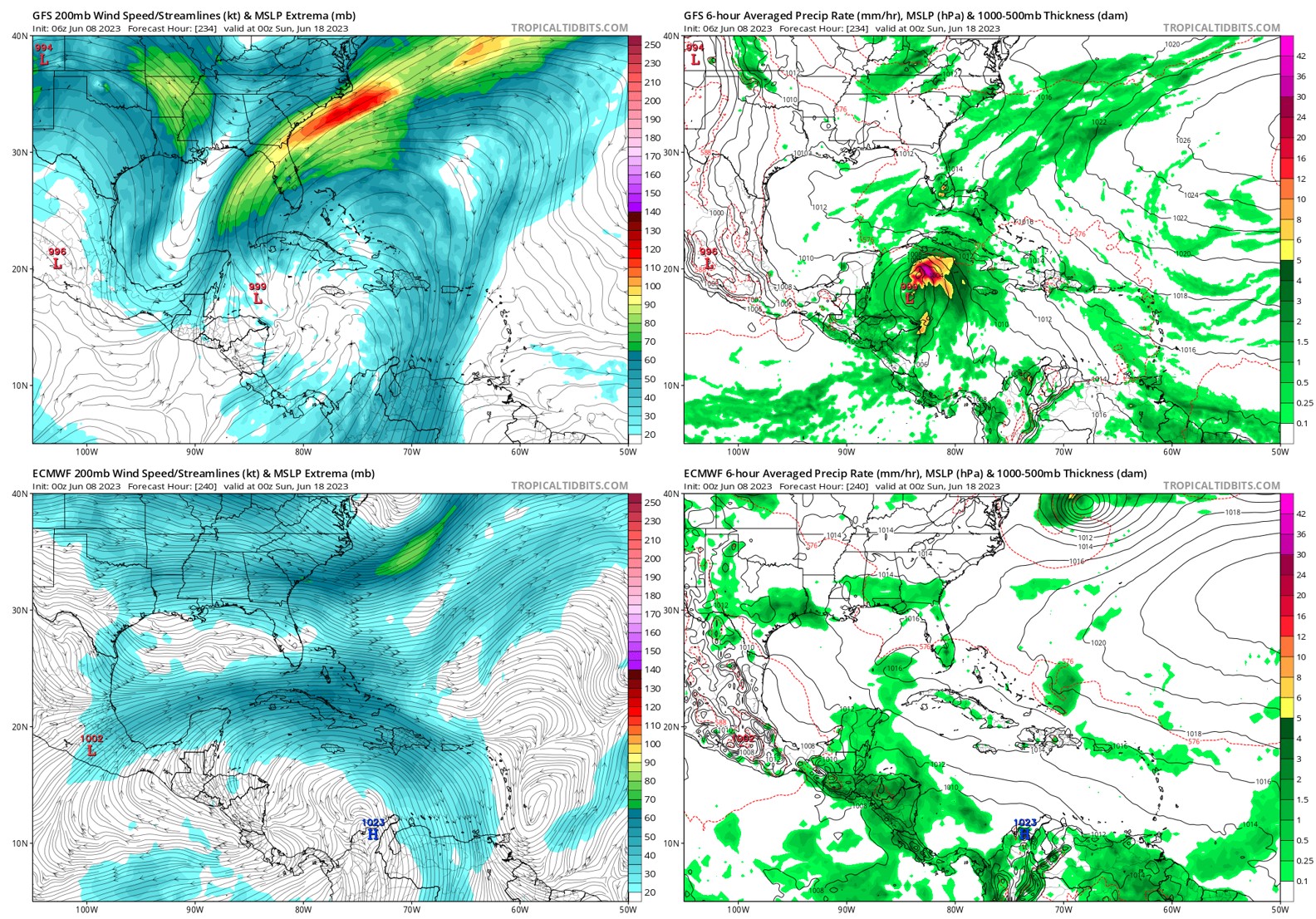
The18z GFS now has something popping up in the EPAC and West Caribbean now in 10 days. I wonder if it'll start shifting toward the east pacific more often.
0 likes
-
wxman57
- Moderator-Pro Met
- Posts: 23175
- Age: 68
- Joined: Sat Jun 21, 2003 8:06 pm
- Location: Houston, TX (southwest)
Re: 2023 Global Model Runs Discussion (Out thru day 16)
Fancy1002 wrote:wxman57 wrote:After seeing Levi's tweet, above, I made a comparison between the 12Z GFS and 12Z Euro for the same time period. They couldn't be more different. Euro has no trof and high shear across the Gulf. Canadian is similar. Careful about believing the outlier model.
http://wxman57.com/images/12ZModels.jpg
Aren’t those two from two separate days. The GFS is from today, but the euro is from yesterday.
Oops, somehow went back a day on the EC, but I fixed it. Still no low in the Gulf in the EC or CMC at that time. Bottom line is that the GFS has a completely different upper air pattern than the other models, and that pattern is changing each run. Just can't believe it.
http://wxman57.com/images/12ZModels2.jpg
0 likes
-
wxman57
- Moderator-Pro Met
- Posts: 23175
- Age: 68
- Joined: Sat Jun 21, 2003 8:06 pm
- Location: Houston, TX (southwest)
Re: 2023 Global Model Runs Discussion (Out thru day 16)
BobHarlem wrote:The18z GFS now has something popping up in the EPAC and West Caribbean now in 10 days. I wonder if it'll start shifting toward the east pacific more often.
EC indicates very strong zonal (east to west) flow at 850mb across the SW Caribbean at day 10 (40 kts). That would suggest any disturbance there would be tracking across CA into the East Pac, which is quite common this time of year. This could signal the start of the East Pac season in 12-14 days.
0 likes
-
SFLcane

- S2K Supporter

- Posts: 10281
- Age: 48
- Joined: Sat Jun 05, 2010 1:44 pm
- Location: Lake Worth Florida
Re: 2023 Global Model Runs Discussion (Out thru day 16)
wxman57 wrote:BobHarlem wrote:The18z GFS now has something popping up in the EPAC and West Caribbean now in 10 days. I wonder if it'll start shifting toward the east pacific more often.
EC indicates very strong zonal (east to west) flow at 850mb across the SW Caribbean at day 10 (40 kts). That would suggest any disturbance there would be tracking across CA into the East Pac, which is quite common this time of year. This could signal the start of the East Pac season in 12-14 days.
Hi 57, care to comment on the new NMME in the indicators thread? Interested in your thoughts.
Thanks!
0 likes

Re: 2023 Global Model Runs Discussion (Out thru day 16)
Euro isn’t even good for genesis. It’s been horrible at that the past couple years.
1 likes
Re: 2023 Global Model Runs Discussion (Out thru day 16)
I agree that the Euro sometimes has issues with genesis while the GFS is prone to being over zealous especially in the western Caribbean. Still think that there is more of a chance for something to form in the WCAR than most are giving but I wouldn’t bet on it.
0 likes
-
Hypercane_Kyle

- Category 5

- Posts: 3465
- Joined: Sat Mar 07, 2015 7:58 pm
- Location: Cape Canaveral, FL
Re: 2023 Global Model Runs Discussion (Out thru day 16)
My guess is we'll see something. Notable GFS ensemble support suggests it's a real signal. GFS, as always, is over-zealous. Likewise, the Euro will almost certainly not pick it up until we are 3-5 days out.

3 likes
My posts are my own personal opinion, defer to the National Hurricane Center (NHC) and other NOAA products for decision making during hurricane season.
Re: 2023 Global Model Runs Discussion (Out thru day 16)
We're now up to 12 GFS runs in a row with a strong W Caribbean and/or Gulf TC forming in week 2. Also, though still mainly quiet, the last 4 EPS runs have shown a subtle increase in activity in the W Caribbean near June 20th.
Whereas the GFS has had a good number of cases in which it has fakes in the W basin even after a lot longer than 12 runs and thus it should continue to be taken with a grain of salt for now, El Niño climo actually does suggest a significantly higher chance for TC genesis in the W Caribbean and Gulf vs non-Nino years in mid to late June. I plan to post more on this soon in the indicators thread.
Whereas the GFS has had a good number of cases in which it has fakes in the W basin even after a lot longer than 12 runs and thus it should continue to be taken with a grain of salt for now, El Niño climo actually does suggest a significantly higher chance for TC genesis in the W Caribbean and Gulf vs non-Nino years in mid to late June. I plan to post more on this soon in the indicators thread.
3 likes
Personal Forecast Disclaimer:
The posts in this forum are NOT official forecasts and should not be used as such. They are just the opinion of the poster and may or may not be backed by sound meteorological data. They are NOT endorsed by any professional institution or storm2k.org. For official information, please refer to the NHC and NWS products.
The posts in this forum are NOT official forecasts and should not be used as such. They are just the opinion of the poster and may or may not be backed by sound meteorological data. They are NOT endorsed by any professional institution or storm2k.org. For official information, please refer to the NHC and NWS products.
-
wxman57
- Moderator-Pro Met
- Posts: 23175
- Age: 68
- Joined: Sat Jun 21, 2003 8:06 pm
- Location: Houston, TX (southwest)
Re: 2023 Global Model Runs Discussion (Out thru day 16)
Again today, the upper-air pattern in the latest GFS run is completely different from both the European model and the Canadian model (not shown below). Zero trof across the Gulf and NW Caribbean in other models, and no tropical development. The GFS has a history of not doing as well with the upper-air pattern than the Euro. In many cases, the GFS may be sniffing something out that ends up tracking west across Central America and into the East Pacific. That may be the case here. I'd be very careful believing the GFS if it cannot get the upper-air pattern correct.
2 likes

Re: 2023 Global Model Runs Discussion (Out thru day 16)
I agree with wxman. It’s notable that the GFS has moved the timeframe up instead of pushing it back run after run like it often does early season. But I expect it’s wrong. Still not bad of a reminder for people to make sure they have supplies and plans in order.
1 likes
-
wxman57
- Moderator-Pro Met
- Posts: 23175
- Age: 68
- Joined: Sat Jun 21, 2003 8:06 pm
- Location: Houston, TX (southwest)
Re: 2023 Global Model Runs Discussion (Out thru day 16)
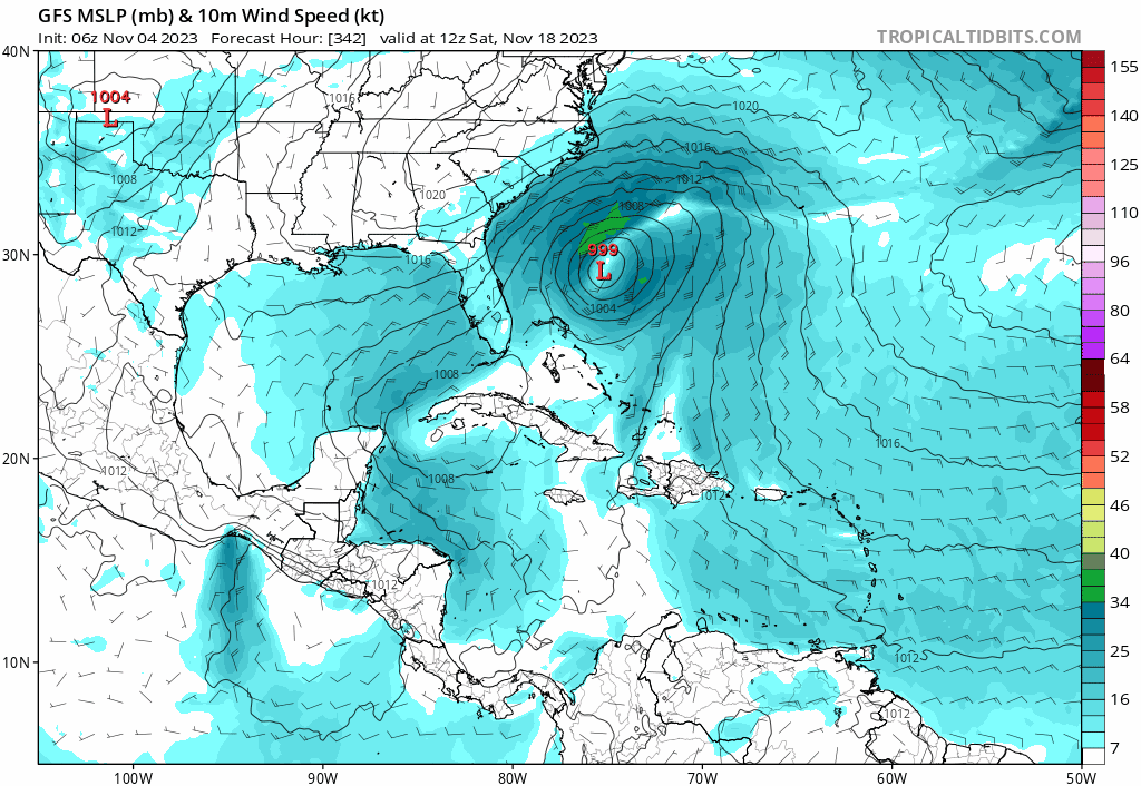
I made a trend graphic showing GFS predictions for Tuesday evening, June 20th.
1 likes
-
toad strangler

- S2K Supporter
- Posts: 4546
- Joined: Sun Jul 28, 2013 3:09 pm
- Location: Earth
- Contact:
Re: 2023 Global Model Runs Discussion (Out thru day 16)
If something were to pop here is 171 years of historical record with two distinct Gulf Coast regional areas. It's been since Reagan was in office when we last saw a June 'cane US landfall. Which Michael Lowry said in his latest update that this is the longest streak by far since 1851.

4 likes
My Weather Station
https://www.wunderground.com/dashboard/pws/KFLPORTS603
https://www.wunderground.com/dashboard/pws/KFLPORTS603
-
cycloneye
- Admin
- Posts: 149697
- Age: 69
- Joined: Thu Oct 10, 2002 10:54 am
- Location: San Juan, Puerto Rico
Re: 2023 Global Model Runs Discussion (Out thru day 16)
The timeframe is approaching 7 days and we will find out if NHC is interested or not.
0 likes
Visit the Caribbean-Central America Weather Thread where you can find at first post web cams,radars
and observations from Caribbean basin members Click Here
and observations from Caribbean basin members Click Here
Re: 2023 Global Model Runs Discussion (Out thru day 16)
cycloneye wrote:The timeframe is approaching 7 days and we will find out if NHC is interested or not.
With the 12Z today, it is up to 13 GFS runs in a row with a strong W Caribbean/GOM TC in week 2.
0 likes
Personal Forecast Disclaimer:
The posts in this forum are NOT official forecasts and should not be used as such. They are just the opinion of the poster and may or may not be backed by sound meteorological data. They are NOT endorsed by any professional institution or storm2k.org. For official information, please refer to the NHC and NWS products.
The posts in this forum are NOT official forecasts and should not be used as such. They are just the opinion of the poster and may or may not be backed by sound meteorological data. They are NOT endorsed by any professional institution or storm2k.org. For official information, please refer to the NHC and NWS products.
Who is online
Users browsing this forum: StPeteMike and 205 guests