ATL: BRET - Models
Moderator: S2k Moderators

-
Kingarabian

- S2K Supporter

- Posts: 16384
- Joined: Sat Aug 08, 2009 3:06 am
- Location: Honolulu, Hawaii
-
cycloneye

- Admin

- Posts: 149844
- Age: 69
- Joined: Thu Oct 10, 2002 10:54 am
- Location: San Juan, Puerto Rico
Re: ATL: INVEST 92L - Models
Wow.

8 likes
Visit the Caribbean-Central America Weather Thread where you can find at first post web cams,radars
and observations from Caribbean basin members Click Here
and observations from Caribbean basin members Click Here
-
Blown Away

- S2K Supporter
- Posts: 10253
- Joined: Wed May 26, 2004 6:17 am
Re: ATL: INVEST 92L - Models
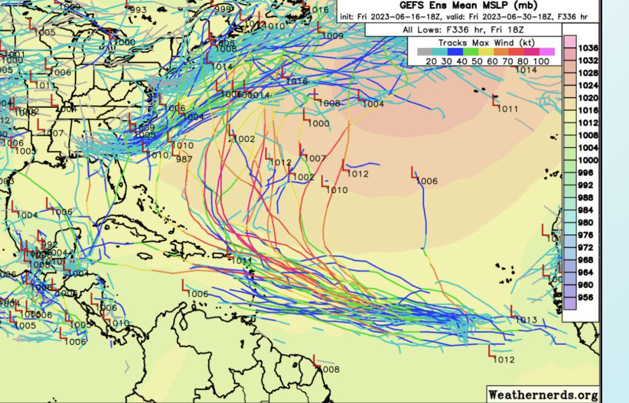
18z GEFS much more active and west. A few majors in the ensembles now very close or through NE Caribbean.
It’s still June regardless of historic SST’s, gotta think the GFS is developing to quickly and we may see development later as it nears NE Caribbean. JMHO
0 likes
Hurricane Eye Experience: David 79, Irene 99, Frances 04, Jeanne 04, Wilma 05… Hurricane Brush Experience: Andrew 92, Erin 95, Floyd 99, Matthew 16, Irma 17, Ian 22, Nicole 22…
-
cycloneye
- Admin
- Posts: 149844
- Age: 69
- Joined: Thu Oct 10, 2002 10:54 am
- Location: San Juan, Puerto Rico
Re: ATL: INVEST 92L - Models
Blown Away wrote:[url]https://i.postimg.cc/CKcvFsQ6/17-C0-BC21-43-F0-441-A-8075-3-BBEB2-A7-BC28.jpg [/url]
18z GEFS much more active and west. A few majors in the ensembles now very close or through NE Caribbean.
It’s still June regardless of historic SST’s, gotta think the GFS is developing to quickly and we may see development later as it nears NE Caribbean. JMHO
Dont like the latest trends and hopefully they go back more far from the islands.
3 likes
Visit the Caribbean-Central America Weather Thread where you can find at first post web cams,radars
and observations from Caribbean basin members Click Here
and observations from Caribbean basin members Click Here
-
cycloneye
- Admin
- Posts: 149844
- Age: 69
- Joined: Thu Oct 10, 2002 10:54 am
- Location: San Juan, Puerto Rico
Re: ATL: INVEST 92L - Models
It will be very interesting when HWRF, HMON and HAFSv03S begin their runs to see how they have the intensity.
2 likes
Visit the Caribbean-Central America Weather Thread where you can find at first post web cams,radars
and observations from Caribbean basin members Click Here
and observations from Caribbean basin members Click Here
-
Blown Away
- S2K Supporter
- Posts: 10253
- Joined: Wed May 26, 2004 6:17 am
Re: ATL: INVEST 92L - Models
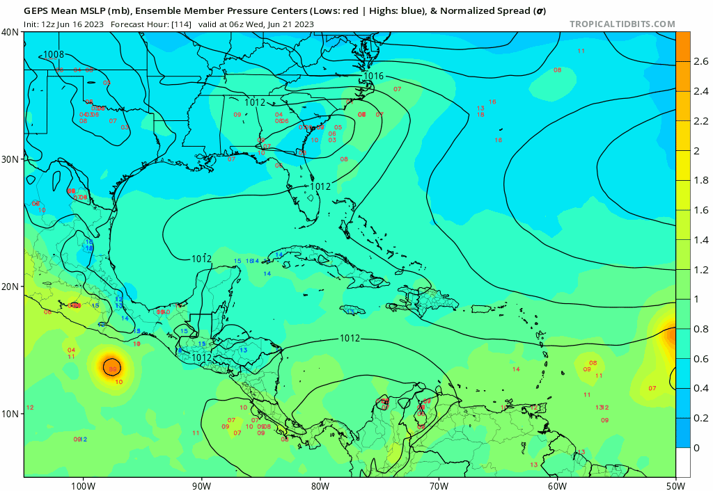
12z GEPS/CMC… Stays on the weak side and through the big islands and into SFL…
0 likes
Hurricane Eye Experience: David 79, Irene 99, Frances 04, Jeanne 04, Wilma 05… Hurricane Brush Experience: Andrew 92, Erin 95, Floyd 99, Matthew 16, Irma 17, Ian 22, Nicole 22…
Re: ATL: INVEST 92L - Models
The 0z icon makes it into the Caribbean, a bit of a change from 12z where it recurved around 52W. Although a bit weaker. Also develops another MDR system behind it. Icon (and cmc) are much weaker than the GFS. The GFS is weaker this run than the 18z, slower, and starts to curve north of the islands around 55w rather than 57w in the 18z.
0z icon

0z gfs (at lowest pressure)

0z icon
0z gfs (at lowest pressure)
0 likes

-
JetFuel_SE

- Category 1

- Posts: 288
- Age: 26
- Joined: Thu Apr 30, 2020 3:57 pm
Re: ATL: INVEST 92L - Models
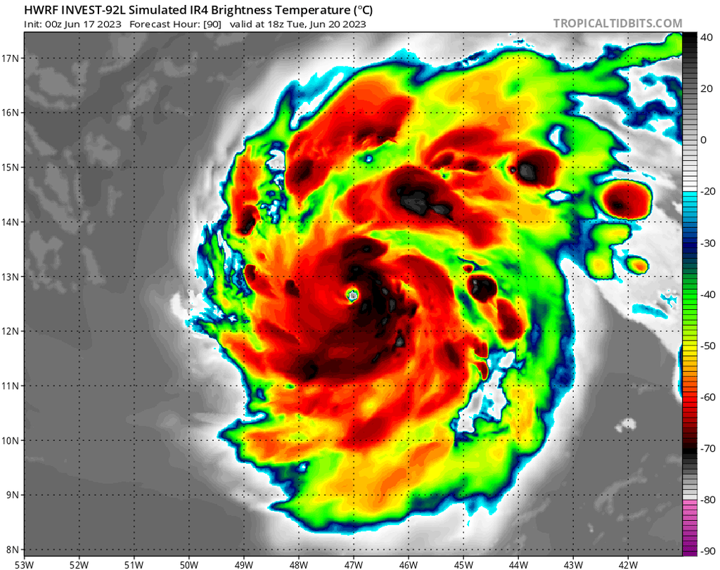
SFLcane wrote:https://i.postimg.cc/C174wnsz/IMG-1286.png
Ah yes, small pinhole-looking eye in an MDR storm in June.
Although it'll likely recurve before then, the Lesser Antilles and Puerto Rico needs to watch this closely, can't rule out significant impacts.
0 likes
-
Blown Away
- S2K Supporter
- Posts: 10253
- Joined: Wed May 26, 2004 6:17 am
Re: ATL: INVEST 92L - Models
00z Euro bringing TS/Cat 1 to NE Caribbean… Weakens in Caribbean and goes through Hispaniola into SE Bahamas… Lots of shear in Caribbean, 92L will have to go N of Caribbean to survive ATM…
2 likes
Hurricane Eye Experience: David 79, Irene 99, Frances 04, Jeanne 04, Wilma 05… Hurricane Brush Experience: Andrew 92, Erin 95, Floyd 99, Matthew 16, Irma 17, Ian 22, Nicole 22…
-
JetFuel_SE
- Category 1
- Posts: 288
- Age: 26
- Joined: Thu Apr 30, 2020 3:57 pm


-
Ivanhater

- Storm2k Moderator

- Posts: 11222
- Age: 39
- Joined: Fri Jul 01, 2005 8:25 am
- Location: Pensacola
Re: ATL: INVEST 92L - Models
Already insane we are probably looking at a Cape Verde hurricane in June but models are picking up on another one right behind this
2 likes
Michael
-
cycloneye
- Admin
- Posts: 149844
- Age: 69
- Joined: Thu Oct 10, 2002 10:54 am
- Location: San Juan, Puerto Rico
Re: ATL: INVEST 92L - Models
0 likes
Visit the Caribbean-Central America Weather Thread where you can find at first post web cams,radars
and observations from Caribbean basin members Click Here
and observations from Caribbean basin members Click Here
-
jlauderdal
- S2K Supporter
- Posts: 7240
- Joined: Wed May 19, 2004 5:46 am
- Location: NE Fort Lauderdale
- Contact:
Re: ATL: INVEST 92L - Models
Blown Away wrote:[url]https://i.postimg.cc/50QQy83m/gem-ememb-lowlocs-watl-fh114-282.gif [/url]
12z GEPS/CMC… Stays on the weak side and through the big islands and into SFL…
Would be quite a change on the position of the ridge from the last few weeks where the trough has been so stubborn, the second system is one to watch
0 likes

Re: ATL: INVEST 92L - Models
06z GFS and HWRF have a TS in about 48 hours or so on Monday morning. That might be a little too rapid given the current state of the wave, but we’ll see how it evolves over the next day.
0 likes
Irene '11 Sandy '12 Hermine '16 5/15/2018 Derecho Fay '20 Isaias '20 Elsa '21 Henri '21 Ida '21
I am only a meteorology enthusiast who knows a decent amount about tropical cyclones. Look to the professional mets, the NHC, or your local weather office for the best information.
I am only a meteorology enthusiast who knows a decent amount about tropical cyclones. Look to the professional mets, the NHC, or your local weather office for the best information.
-
cycloneye
- Admin
- Posts: 149844
- Age: 69
- Joined: Thu Oct 10, 2002 10:54 am
- Location: San Juan, Puerto Rico
Re: ATL: INVEST 92L - Models
06z HMON has cat 3 east of Guadeloupe around 55W.

1 likes
Visit the Caribbean-Central America Weather Thread where you can find at first post web cams,radars
and observations from Caribbean basin members Click Here
and observations from Caribbean basin members Click Here
-
cycloneye
- Admin
- Posts: 149844
- Age: 69
- Joined: Thu Oct 10, 2002 10:54 am
- Location: San Juan, Puerto Rico
Re: ATL: INVEST 92L - Models
0 likes
Visit the Caribbean-Central America Weather Thread where you can find at first post web cams,radars
and observations from Caribbean basin members Click Here
and observations from Caribbean basin members Click Here
Who is online
Users browsing this forum: No registered users and 3 guests