ATL: BRET - Remnants - Discussion
Moderator: S2k Moderators


Re: ATL: INVEST 92L - Discussion
Bold Prediction…still another 48-72 hrs before TCG from 92L. Convection will wain tonight and 92L will be a shell of what it was by morning…it will struggle all Sunday into Sunday night producing any convection, and will start to come back Monday. Will probably see designation Tuesday. This is given past experience with these early season systems.
0 likes
-
cycloneye

- Admin

- Posts: 149716
- Age: 69
- Joined: Thu Oct 10, 2002 10:54 am
- Location: San Juan, Puerto Rico
Re: ATL: INVEST 92L - Discussion
Tropical Weather Outlook
NWS National Hurricane Center Miami FL
800 AM EDT Sun Jun 18 2023
For the North Atlantic...Caribbean Sea and the Gulf of Mexico:
1. Eastern Tropical Atlantic (AL92):
Showers and thunderstorms continue to show signs of organization in
association with a tropical wave located several hundred miles
southwest of the Cabo Verde Islands. Environmental conditions appear
conducive for additional development, and a tropical depression is
likely to form over the next day or two. This system is expected to
move westward at 15 to 20 mph across the eastern and central
tropical Atlantic through the middle part of the week.
* Formation chance through 48 hours...high...80 percent.
* Formation chance through 7 days...high...90 percent.
Forecaster Blake
Now direct to the islands.

3 likes
Visit the Caribbean-Central America Weather Thread where you can find at first post web cams,radars
and observations from Caribbean basin members Click Here
and observations from Caribbean basin members Click Here
-
cycloneye
- Admin
- Posts: 149716
- Age: 69
- Joined: Thu Oct 10, 2002 10:54 am
- Location: San Juan, Puerto Rico
Re: ATL: INVEST 92L - Discussion
0 likes
Visit the Caribbean-Central America Weather Thread where you can find at first post web cams,radars
and observations from Caribbean basin members Click Here
and observations from Caribbean basin members Click Here
-
Hypercane_Kyle

- Category 5

- Posts: 3465
- Joined: Sat Mar 07, 2015 7:58 pm
- Location: Cape Canaveral, FL
Re: ATL: INVEST 92L - Discussion
Rough dmax, but still looks promising.

3 likes
My posts are my own personal opinion, defer to the National Hurricane Center (NHC) and other NOAA products for decision making during hurricane season.
-
cycloneye
- Admin
- Posts: 149716
- Age: 69
- Joined: Thu Oct 10, 2002 10:54 am
- Location: San Juan, Puerto Rico
Re: ATL: INVEST 92L - Discussion
12z Best Track:
https://ftp.nhc.noaa.gov/atcf/btk/bal922023.dat
https://ftp.nhc.noaa.gov/atcf/btk/bal922023.dat
AL, 92, 2023061812, , BEST, 0, 97N, 319W, 25, 1010, WV
1 likes
Visit the Caribbean-Central America Weather Thread where you can find at first post web cams,radars
and observations from Caribbean basin members Click Here
and observations from Caribbean basin members Click Here
-
ScottNAtlanta

- Category 5
- Posts: 2535
- Joined: Sat May 25, 2013 3:11 pm
- Location: Atlanta, GA
Re: ATL: INVEST 92L - Discussion
A good recap on 92L
[youtube]https://youtu.be/5cLmJHevIFE[/youtube]
[youtube]https://youtu.be/5cLmJHevIFE[/youtube]
1 likes
The posts in this forum are NOT official forecast and should not be used as such. They are just the opinion of the poster and may or may not be backed by sound meteorological data. They are NOT endorsed by any professional institution or storm2k.org. For official information, please refer to the NHC and NWS products.
-
wxman57

- Moderator-Pro Met

- Posts: 23175
- Age: 68
- Joined: Sat Jun 21, 2003 8:06 pm
- Location: Houston, TX (southwest)
Re: ATL: INVEST 92L - Discussion
WiscoWx02 wrote:Bold Prediction…still another 48-72 hrs before TCG from 92L. Convection will wain tonight and 92L will be a shell of what it was by morning…it will struggle all Sunday into Sunday night producing any convection, and will start to come back Monday. Will probably see designation Tuesday. This is given past experience with these early season systems.
Not too bold. I'm issuing our first 7-day track now. Have it reaching TD at 48 hrs (Tuesday AM) and 35 kts Tuesday night. Peaks 45 kts Thursday then weakens to 35 kts as it passes Guadeloupe Friday morning and a remnant low south of PR over the weekend. I totally ignored the GFS.
5 likes
-
MarioProtVI
- Category 5
- Posts: 1039
- Age: 24
- Joined: Sun Sep 29, 2019 7:33 pm
- Location: New Jersey
Re: ATL: INVEST 92L - Discussion
WiscoWx02 wrote:Bold Prediction…still another 48-72 hrs before TCG from 92L. Convection will wain tonight and 92L will be a shell of what it was by morning…it will struggle all Sunday into Sunday night producing any convection, and will start to come back Monday. Will probably see designation Tuesday. This is given past experience with these early season systems.
I’d say it’s more likely we see TCG late tonight or, barring that, early-mid afternoon tomorrow. The recent DMAX appears to have consolidated the circulation somewhat but it’s still not there yet. Next DMAX should be enough to push it over.
2 likes
-
MarioProtVI
- Category 5
- Posts: 1039
- Age: 24
- Joined: Sun Sep 29, 2019 7:33 pm
- Location: New Jersey
Re: ATL: INVEST 92L - Discussion
wxman57 wrote:WiscoWx02 wrote:Bold Prediction…still another 48-72 hrs before TCG from 92L. Convection will wain tonight and 92L will be a shell of what it was by morning…it will struggle all Sunday into Sunday night producing any convection, and will start to come back Monday. Will probably see designation Tuesday. This is given past experience with these early season systems.
Not too bold. I'm issuing our first 7-day track now. Have it reaching TD at 48 hrs (Tuesday AM) and 35 kts Tuesday night. Peaks 45 kts Thursday then weakens to 35 kts as it passes Guadeloupe Friday morning and a remnant low south of PR over the weekend. I totally ignored the GFS.
The Euro trended stronger overnight so you might be on a bit of the bearish side. 65-75 kt seems like a good range IMO, since models seem to agree with a 995-980 range it seems. We’ll see.
1 likes
-
wxman57
- Moderator-Pro Met
- Posts: 23175
- Age: 68
- Joined: Sat Jun 21, 2003 8:06 pm
- Location: Houston, TX (southwest)
Re: ATL: INVEST 92L - Discussion
MarioProtVI wrote:wxman57 wrote:WiscoWx02 wrote:Bold Prediction…still another 48-72 hrs before TCG from 92L. Convection will wain tonight and 92L will be a shell of what it was by morning…it will struggle all Sunday into Sunday night producing any convection, and will start to come back Monday. Will probably see designation Tuesday. This is given past experience with these early season systems.
Not too bold. I'm issuing our first 7-day track now. Have it reaching TD at 48 hrs (Tuesday AM) and 35 kts Tuesday night. Peaks 45 kts Thursday then weakens to 35 kts as it passes Guadeloupe Friday morning and a remnant low south of PR over the weekend. I totally ignored the GFS.
The Euro trended stronger overnight so you might be on a bit of the bearish side. 65-75 kt seems like a good range IMO, since models seem to agree with a 995-980 range it seems. We’ll see.
If it's stronger, then it won't reach the NE Caribbean, it'll turn north like the GFS.
5 likes
-
Sciencerocks
- Category 5
- Posts: 10193
- Age: 40
- Joined: Thu Jul 06, 2017 1:51 am
Re: ATL: INVEST 92L - Discussion

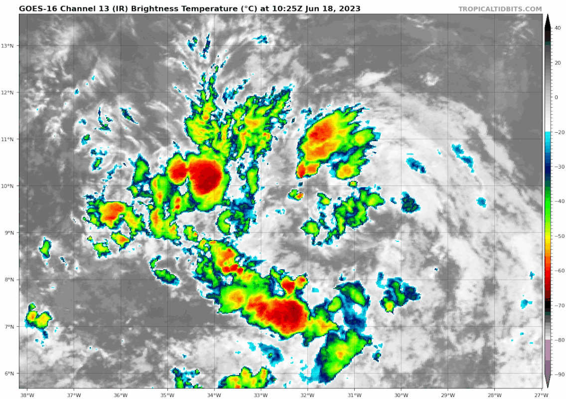
Looks to be slightly more define at the low levels, convergence zone collapsed so that is leading towards the tiny amount of convection focusing near the center, anti-cyclone that was off to the southeast last night(as in on the unfavorable northwestern quad and which it and the tutt to the northwest was of course shearing it) is now protecting the core and so it is now all about producing convection to tighten the LLC and strengthen the wind field. We will see how long it takes to become a depression.
3 likes

Re: ATL: INVEST 92L - Discussion
wxman57 wrote:MarioProtVI wrote:wxman57 wrote:
Not too bold. I'm issuing our first 7-day track now. Have it reaching TD at 48 hrs (Tuesday AM) and 35 kts Tuesday night. Peaks 45 kts Thursday then weakens to 35 kts as it passes Guadeloupe Friday morning and a remnant low south of PR over the weekend. I totally ignored the GFS.
The Euro trended stronger overnight so you might be on a bit of the bearish side. 65-75 kt seems like a good range IMO, since models seem to agree with a 995-980 range it seems. We’ll see.
If it's stronger, then it won't reach the NE Caribbean, it'll turn north like the GFS.
I'm just a weather observer here but can someone explain to me, and I read this all the time, why a stronger storm will get pull towards
the pole and weaker one will continue more westerly?
Thanks
0 likes
-
Sciencerocks
- Category 5
- Posts: 10193
- Age: 40
- Joined: Thu Jul 06, 2017 1:51 am
Re: ATL: INVEST 92L - Discussion
Weaker = shallower
Stronger = deeper
A weaker storm will be moved within the low levels, which has more ridging, while a stronger storm will feel the weakness more and turn into it. This is why the models are in two camps...
Stronger = deeper
A weaker storm will be moved within the low levels, which has more ridging, while a stronger storm will feel the weakness more and turn into it. This is why the models are in two camps...
1 likes

Re: ATL: INVEST 92L - Discussion
A bit surprised by the lack of convection near the center today, but that's a huge band lol.
1 likes
TC naming lists: retirements and intensity
Most aggressive Advisory #1's in North Atlantic (cr. kevin for starting the list)
Most aggressive Advisory #1's in North Atlantic (cr. kevin for starting the list)


Re: ATL: INVEST 92L - Discussion
Very nice 700mb vort on Vis and IR Satellites
If it can maintain to 50W, where it will pickup Amazon moisture, could ramp up then and work vort to the surface.
If it can maintain to 50W, where it will pickup Amazon moisture, could ramp up then and work vort to the surface.
0 likes
Re: ATL: INVEST 92L - Discussion
Does anyone else getting Hurricane Hugo vibes from this system.
0 likes
Personal Forecast Disclaimer:
The posts in this forum are NOT official forecast and should not be used as such. They are just the opinion of the poster and may or may not be backed by sound meteorological data. They are NOT endorsed by any professional institution or storm2k.org. For official information, please refer to the NHC and NWS products.
The posts in this forum are NOT official forecast and should not be used as such. They are just the opinion of the poster and may or may not be backed by sound meteorological data. They are NOT endorsed by any professional institution or storm2k.org. For official information, please refer to the NHC and NWS products.
-
cycloneye
- Admin
- Posts: 149716
- Age: 69
- Joined: Thu Oct 10, 2002 10:54 am
- Location: San Juan, Puerto Rico
Re: ATL: INVEST 92L - Discussion
We need an ASCAT pass to see how is the structure, but looks good now.

2 likes
Visit the Caribbean-Central America Weather Thread where you can find at first post web cams,radars
and observations from Caribbean basin members Click Here
and observations from Caribbean basin members Click Here
Re: ATL: INVEST 92L - Discussion
Blinhart wrote:Does anyone else getting Hurricane Hugo vibes from this system.
Given the insane water temps and record CAPE values, anywhere from Cape Hatteras to the entire GoM is giving me the chills
3 likes

Re: ATL: INVEST 92L - Discussion
Insane to see that red sausage pointing at the islands already this early, on Father's Day! Nothing normal about this season indeed. Strong hurricanes have happened this time of year in that area before, although rare. 1780 had the St. Lucia hurricane hit the leewards on June 12-13, so it can happen. Gonna keep my eye on this one for sure!
4 likes
Georges '98, Irene '99, Frances '04, Jeanne '04, Katrina '05, Wilma '05, Gustav '08, Isaac '12, Matthew '16, Florence '18, Michael '18, Ian '22
Who is online
Users browsing this forum: No registered users and 77 guests