ATL: BRET - Remnants - Discussion

Moderator: S2k Moderators

Message
Author
GeauxTigers
Tropical Storm
Tropical Storm
Posts: 104
Joined: Sun Jan 14, 2018 5:35 pm
Location: Tioga, TX

Re: ATL: BRET - Tropical Storm - Discussion

#281 Postby GeauxTigers » Mon Jun 19, 2023 9:27 pm

painkillerr wrote:
wxman57 wrote:New consensus is farther south of NHC track and a lot faster than NHC. TVCN track is now south of Martinique. NHC's track seems to be about 12-18 hrs too slow for reaching the islands. I still think it will weaken considerably as it nears the islands, down to a remnant low south of the DR.


Do you expect an impact for the US and British Virgin Islands?


Yes, great question! Hoping someone can answer you.
0 likes   

Hurricane Mike
Category 2
Category 2
Posts: 644
Joined: Tue Apr 10, 2018 7:44 am

Re: ATL: BRET - Tropical Storm - Discussion

#282 Postby Hurricane Mike » Mon Jun 19, 2023 9:43 pm

wxman57 wrote:New consensus is farther south of NHC track and a lot faster than NHC. TVCN track is now south of Martinique. NHC's track seems to be about 12-18 hrs too slow for reaching the islands. I still think it will weaken considerably as it nears the islands, down to a remnant low south of the DR.


You really think conditions will become that hostile? To the point of total dissipation?
0 likes   

IsabelaWeather
Category 1
Category 1
Posts: 287
Age: 35
Joined: Tue Jul 07, 2020 7:29 am
Location: Isabela, Puerto Rico

Re: ATL: BRET - Tropical Storm - Discussion

#283 Postby IsabelaWeather » Mon Jun 19, 2023 10:07 pm

Latest IR really looks like some deep convection going up in 4 quadrants around the CoC. Really curious what happens with this by morning. Starting to get the shrimp look too
0 likes   

User avatar
ElectricStorm
Category 5
Category 5
Posts: 5044
Age: 24
Joined: Tue Aug 13, 2019 11:23 pm
Location: Skiatook, OK / Norman, OK

Re: ATL: BRET - Tropical Storm - Discussion

#284 Postby ElectricStorm » Mon Jun 19, 2023 10:41 pm

With the way it's looking right now I don't really see this having any issues making it to Cat 1 hurricane strength before shear/dry air takes over closer to the islands. Probably won't get much stronger than that but I think we'll see perhaps a 65-75kt peak before the islands. Crazy system for June.
4 likes   
B.S Meteorology, University of Oklahoma '25

Please refer to the NHC, NWS, or SPC for official information.

User avatar
Teban54
Category 5
Category 5
Posts: 3204
Joined: Sat May 19, 2018 1:19 pm

Re: ATL: BRET - Tropical Storm - Discussion

#285 Postby Teban54 » Tue Jun 20, 2023 12:19 am

2 likes   

Sciencerocks
Category 5
Category 5
Posts: 9155
Age: 39
Joined: Thu Jul 06, 2017 1:51 am

Re: ATL: BRET - Tropical Storm - Discussion

#286 Postby Sciencerocks » Tue Jun 20, 2023 2:15 am

Image
3 likes   

MarioProtVI
Category 4
Category 4
Posts: 935
Age: 24
Joined: Sun Sep 29, 2019 7:33 pm
Location: New Jersey

Re: ATL: BRET - Tropical Storm - Discussion

#287 Postby MarioProtVI » Tue Jun 20, 2023 2:34 am

It’s honestly baffling NHC is refusing to raise the intensity because it’s clearly stronger then 35 kt right now. More likely 40-45 kt
4 likes   

Chemmers
Tropical Storm
Tropical Storm
Posts: 220
Joined: Wed Jul 22, 2020 6:16 am

Re: ATL: BRET - Tropical Storm - Discussion

#288 Postby Chemmers » Tue Jun 20, 2023 3:12 am

Defo starting to have a shimp look about it
2 likes   

Chemmers
Tropical Storm
Tropical Storm
Posts: 220
Joined: Wed Jul 22, 2020 6:16 am

Re: ATL: BRET - Tropical Storm - Discussion

#289 Postby Chemmers » Tue Jun 20, 2023 5:08 am

Looking good on satellite this morning think will see an 10 to 15 mph increase on there next advisory
0 likes   

User avatar
GCANE
S2K Supporter
S2K Supporter
Posts: 11496
Joined: Mon Oct 22, 2007 8:03 am

Re: ATL: BRET - Tropical Storm - Discussion

#290 Postby GCANE » Tue Jun 20, 2023 5:31 am

Looks like it'll continue to strengthen.
Convection firing off a shear gradient and in-the-clear 335K PV over it.

IMHO models may be over doing the shear once in the Carib
Anti-cyclone will be setup centered in the West / Mid Carib
Bret will hit the 250mb N to S flow of the anti-cyclone in the east Carib.
This is the shear that models are saying will shred Bret.
However, models indicate the directional shear is only at the high level.
Mid-level shear is actually quite low, 500mb to the surface.
It may have enough convection to get thru this and dive into and under the anti-cyclone.
Once that happens intensification would be very likely.
Just need to wait and see.
1 likes   

User avatar
GCANE
S2K Supporter
S2K Supporter
Posts: 11496
Joined: Mon Oct 22, 2007 8:03 am

Re: ATL: BRET - Tropical Storm - Discussion

#291 Postby GCANE » Tue Jun 20, 2023 5:34 am

Archer satellite location estimates have Bret significantly south of forecast track.
https://tropic.ssec.wisc.edu/real-time/ ... /track.png

Of course, nothing better than recon to give an accurate location.
0 likes   

User avatar
GCANE
S2K Supporter
S2K Supporter
Posts: 11496
Joined: Mon Oct 22, 2007 8:03 am

Re: ATL: BRET - Tropical Storm - Discussion

#292 Postby GCANE » Tue Jun 20, 2023 5:43 am

Model updates now having a more straight west track into the Carib

https://rammb-data.cira.colostate.edu/t ... 191800.png
0 likes   

User avatar
Teban54
Category 5
Category 5
Posts: 3204
Joined: Sat May 19, 2018 1:19 pm

Re: ATL: BRET - Tropical Storm - Discussion

#293 Postby Teban54 » Tue Jun 20, 2023 5:49 am

0 likes   

User avatar
NotSparta
Professional-Met
Professional-Met
Posts: 1668
Age: 23
Joined: Fri Aug 18, 2017 8:24 am
Location: Naples, FL
Contact:

Re: ATL: BRET - Tropical Storm - Discussion

#294 Postby NotSparta » Tue Jun 20, 2023 5:54 am

Center is pretty close to the edge of convection. Would be hard to intensify like this

Image
7 likes   
This post was probably an opinion of mine, and in no way is official. Please refer to http://www.hurricanes.gov for official tropical analysis and advisories.

My website, with lots of tropical wx graphics, including satellite and recon: http://cyclonicwx.com

User avatar
Stormybajan
Category 1
Category 1
Posts: 448
Joined: Thu May 20, 2021 3:21 pm
Location: Windward Islands

Re: ATL: BRET - Tropical Storm - Discussion

#295 Postby Stormybajan » Tue Jun 20, 2023 6:13 am

NotSparta wrote:Center is pretty close to the edge of convection. Would be hard to intensify like this

https://cdn.discordapp.com/attachments/661421636003823632/1120667894297137172/center_convection.gif

Yeah, I was about to ask whats causing the convection to move away from the center, is it shear, or dry air? Think NHC will have to drop their forecast down to 65 mph instead of the 75 mph forecast currently. Truthfully I thought today would have prime conditions for Bret given its hitting more OHC also and more to its west..the center popping out is giving me a big :?:
3 likes   
Sad West Indies and Manchester United fan ⚽️

User avatar
NotSparta
Professional-Met
Professional-Met
Posts: 1668
Age: 23
Joined: Fri Aug 18, 2017 8:24 am
Location: Naples, FL
Contact:

Re: ATL: BRET - Tropical Storm - Discussion

#296 Postby NotSparta » Tue Jun 20, 2023 6:23 am

Stormybajan wrote:
NotSparta wrote:Center is pretty close to the edge of convection. Would be hard to intensify like this

https://cdn.discordapp.com/attachments/661421636003823632/1120667894297137172/center_convection.gif

Yeah, I was about to ask whats causing the convection to move away from the center, is it shear, or dry air? Think NHC will have to drop their forecast down to 65 mph instead of the 75 mph forecast currently. Truthfully I thought today would have prime conditions for Bret given its hitting more OHC also and more to its west..the center popping out is giving me a big :?:


Shear, particularly mid-level. Looks like it set in early. No dry air to speak of at the moment, not even a single outflow boundary in the area which suggests a reasonably moist environment. May deal with dry air later though
4 likes   
This post was probably an opinion of mine, and in no way is official. Please refer to http://www.hurricanes.gov for official tropical analysis and advisories.

My website, with lots of tropical wx graphics, including satellite and recon: http://cyclonicwx.com

User avatar
NDG
S2K Supporter
S2K Supporter
Posts: 15446
Joined: Sun Jul 09, 2006 10:14 pm
Location: Orlando, FL

Re: ATL: BRET - Tropical Storm - Discussion

#297 Postby NDG » Tue Jun 20, 2023 6:25 am

Its structure is not that bad, at least as of 5 hrs ago.

Image
1 likes   

User avatar
wxman57
Moderator-Pro Met
Moderator-Pro Met
Posts: 22978
Age: 67
Joined: Sat Jun 21, 2003 8:06 pm
Location: Houston, TX (southwest)

Re: ATL: BRET - Tropical Storm - Discussion

#298 Postby wxman57 » Tue Jun 20, 2023 6:37 am

painkillerr wrote:
wxman57 wrote:New consensus is farther south of NHC track and a lot faster than NHC. TVCN track is now south of Martinique. NHC's track seems to be about 12-18 hrs too slow for reaching the islands. I still think it will weaken considerably as it nears the islands, down to a remnant low south of the DR.


Do you expect an impact for the US and British Virgin Islands?


Very little impact that far north. Very slight increase in easterly trade winds and a few showers. I have a briefing for a client in St. Croix at 8:30am.
0 likes   

User avatar
wxman57
Moderator-Pro Met
Moderator-Pro Met
Posts: 22978
Age: 67
Joined: Sat Jun 21, 2003 8:06 pm
Location: Houston, TX (southwest)

Re: ATL: BRET - Tropical Storm - Discussion

#299 Postby wxman57 » Tue Jun 20, 2023 6:37 am

I see the NHC is coming around to a weakening storm reaching Caribbean at a faster pace. Will likely be weaker than they're predicting by day 5. Possibly a depression then.
1 likes   

User avatar
NDG
S2K Supporter
S2K Supporter
Posts: 15446
Joined: Sun Jul 09, 2006 10:14 pm
Location: Orlando, FL

Re: ATL: BRET - Tropical Storm - Discussion

#300 Postby NDG » Tue Jun 20, 2023 6:57 am

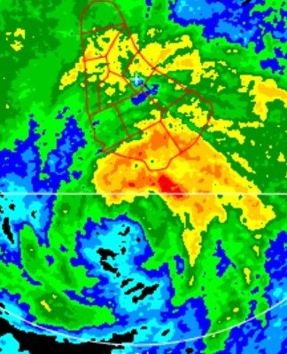
Newer microwave pass shows what we are seeing on vis satellite this morning, its LLC well displaced from the deep convection, not much strengthening today.

Image
1 likes   


Return to “2023”

Who is online

Users browsing this forum: No registered users and 7 guests