

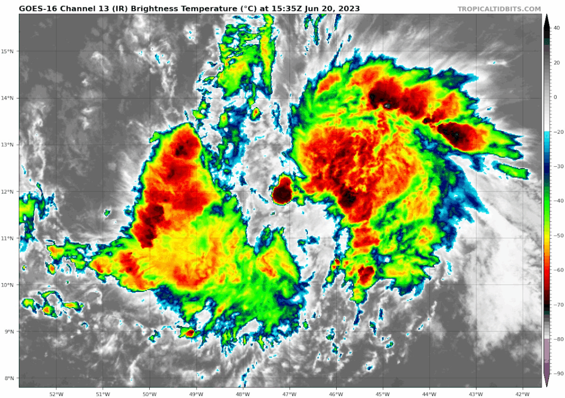
Nice helicity developing with that LLC convection.
Looks like a legit long-term hot tower.
It aint dead yet Jim
ATL: BRET - Remnants - Discussion
Moderator: S2k Moderators
-
ElectricStorm

- Category 5

- Posts: 5140
- Age: 25
- Joined: Tue Aug 13, 2019 11:23 pm
- Location: Norman, OK
Re: ATL: BRET - Tropical Storm - Discussion
Certainly looks a lot worse now than I expected it to last night, it's chances of becoming a hurricane have definitely taken a big hit. That being said, nice new burst of convection over the center, if that can sustain and continue to build this time without the center becoming exposed again, I could still see this having around a 55-65kt peak or so. Needs to get going soon though since it's time in favorable conditions is becoming limited.
0 likes
B.S Meteorology, University of Oklahoma '25
Please refer to the NHC, NWS, or SPC for official information.
Please refer to the NHC, NWS, or SPC for official information.
Re: ATL: BRET - Tropical Storm - Discussion
Hot tower creating a symmetric CDO.
Very little shear.
Very little shear.
2 likes

-
tolakram
- Admin

- Posts: 20179
- Age: 62
- Joined: Sun Aug 27, 2006 8:23 pm
- Location: Florence, KY (name is Mark)
Re: ATL: BRET - Tropical Storm - Discussion

2 likes
M a r k
- - - - -
Join us in chat: Storm2K Chatroom Invite. Android and IOS apps also available.
The posts in this forum are NOT official forecasts and should not be used as such. Posts are NOT endorsed by any professional institution or STORM2K.org. For official information and forecasts, please refer to NHC and NWS products.
Re: ATL: BRET - Tropical Storm - Discussion
Very strong updraft, the PV anomaly is dead for sure.
Convection much stronger than anything around it.
Good chance won't see anymore PV streamers from downdrafts of the surrounding convection.
Convection much stronger than anything around it.
Good chance won't see anymore PV streamers from downdrafts of the surrounding convection.
0 likes

Re: ATL: BRET - Tropical Storm - Discussion
Tops blew off near -45 as I expected but Brett looks like he is working some of the dry air out.
Recon data will be useful for the island forecast. Caribbean is still a hostile though.
Recon data will be useful for the island forecast. Caribbean is still a hostile though.
0 likes

-
cheezyWXguy

- Category 5
- Posts: 6281
- Joined: Mon Feb 13, 2006 12:29 am
- Location: Dallas, TX
Re: ATL: BRET - Tropical Storm - Discussion
Clear improvement but it looks like the center is tucked just under the western edge of that burst. As long as it can keep firing off bursts like this it should become better stacked with time.
0 likes
-
cycloneye

- Admin
- Posts: 149276
- Age: 69
- Joined: Thu Oct 10, 2002 10:54 am
- Location: San Juan, Puerto Rico
Re: ATL: BRET - Tropical Storm - Discussion
Up to 3.0
TXNT28 KNES 201823
TCSNTL
A. 03L (BRET)
B. 20/1800Z
C. 12.2N
D. 47.9W
E. THREE/GOES-E
F. T3.0/3.0
G. IR/EIR/VIS/AMSR2
H. REMARKS...A WELL DEFINED CDO MEASURING SLIGHTLY MORE THAN 60 NM
RESULTS IN A DT OF 3.0 AFTER ADDING 0.5 FOR A BANDING FEATURE THAT LIES
EAST OF THE CDO. MET IS 2.5 BASED ON A 24 HOUR STEADY TREND. PT IS ALSO
2.5. THE FT IS BASED ON THE DT.
I. ADDL POSITIONS
20/1641Z 12.2N 47.6W AMSR2
...TURK
0 likes
Visit the Caribbean-Central America Weather Thread where you can find at first post web cams,radars
and observations from Caribbean basin members Click Here
and observations from Caribbean basin members Click Here
-
cycloneye
- Admin
- Posts: 149276
- Age: 69
- Joined: Thu Oct 10, 2002 10:54 am
- Location: San Juan, Puerto Rico
Re: ATL: BRET - Tropical Storm - Discussion
Up to 40kt at 18z Best Track.
AL, 03, 2023062018, , BEST, 0, 121N, 480W, 40, 1006, TS
0 likes
Visit the Caribbean-Central America Weather Thread where you can find at first post web cams,radars
and observations from Caribbean basin members Click Here
and observations from Caribbean basin members Click Here

Re: ATL: BRET - Tropical Storm - Discussion
12z Euro throws out the idea of Bret dissipating before reaching the Islands. It actually shows it becoming a hurricane for a short period early Thursday morning then weakening some before tracking through the Islands but shows near 70 mph wind gusts affecting the Islands.
1 likes
Re: ATL: BRET - Tropical Storm - Discussion: 18z Best Track up to 40kt
Looking better than this morning.

0 likes
-
wxman57

- Moderator-Pro Met

- Posts: 23172
- Age: 68
- Joined: Sat Jun 21, 2003 8:06 pm
- Location: Houston, TX (southwest)
Re: ATL: BRET - Tropical Storm - Discussion
NDG wrote:12z Euro throws out the idea of Bret dissipating before reaching the Islands. It actually shows it becoming a hurricane for a short period early Thursday morning then weakening some before tracking through the Islands but shows near 70 mph wind gusts affecting the Islands.
I'm not seeing that in the 12Z EC, NDG. I see a peak wind of 48 kts early Thursday, followed by weakening (Pivotal Weather). Down to 43 kts as it reaches the islands Thursday evening. Dissipation in east Caribbean.
1 likes
Re: ATL: BRET - Tropical Storm - Discussion
wxman57 wrote:NDG wrote:12z Euro throws out the idea of Bret dissipating before reaching the Islands. It actually shows it becoming a hurricane for a short period early Thursday morning then weakening some before tracking through the Islands but shows near 70 mph wind gusts affecting the Islands.
I'm not seeing that in the 12Z EC, NDG. I see a peak wind of 48 kts early Thursday, followed by weakening (Pivotal Weather). Down to 43 kts as it reaches the islands Thursday evening. Dissipation in east Caribbean.
Is on weather.us, HR run.
Pressure of 990mb, 82 mph winds with 119mph gusts, for a very quick period, 2-3 hr.


4 likes
-
floridasun
- Tropical Storm

- Posts: 245
- Joined: Tue Sep 14, 2021 3:59 pm
Re: ATL: BRET - Tropical Storm - Discussion
cycloneye wrote:Up to 40kt at 18z Best Track.AL, 03, 2023062018, , BEST, 0, 121N, 480W, 40, 1006, TS
that 50mph?
0 likes
-
cycloneye
- Admin
- Posts: 149276
- Age: 69
- Joined: Thu Oct 10, 2002 10:54 am
- Location: San Juan, Puerto Rico
Re: ATL: BRET - Tropical Storm - Discussion
floridasun wrote:cycloneye wrote:Up to 40kt at 18z Best Track.AL, 03, 2023062018, , BEST, 0, 121N, 480W, 40, 1006, TS
that 50mph?
Is 45 mph.
0 likes
Visit the Caribbean-Central America Weather Thread where you can find at first post web cams,radars
and observations from Caribbean basin members Click Here
and observations from Caribbean basin members Click Here
-
wxman57
- Moderator-Pro Met
- Posts: 23172
- Age: 68
- Joined: Sat Jun 21, 2003 8:06 pm
- Location: Houston, TX (southwest)
Re: ATL: BRET - Tropical Storm - Discussion
NDG wrote:wxman57 wrote:NDG wrote:12z Euro throws out the idea of Bret dissipating before reaching the Islands. It actually shows it becoming a hurricane for a short period early Thursday morning then weakening some before tracking through the Islands but shows near 70 mph wind gusts affecting the Islands.
I'm not seeing that in the 12Z EC, NDG. I see a peak wind of 48 kts early Thursday, followed by weakening (Pivotal Weather). Down to 43 kts as it reaches the islands Thursday evening. Dissipation in east Caribbean.
Is on weather.us, HR run.
Pressure of 990mb, 82 mph winds with 119mph gusts, for a very quick period, 2-3 hr.
https://i.imgur.com/b56WzY3.png
https://i.imgur.com/0jA2B4e.png
https://i.imgur.com/5N7r3Ah.png
They hide their maps well on that site. All I can find is a map showing the U.S. Can't find a tropical section. Must need to pay for a subscription.
I plotted the winds on our high-res version and I see the higher winds at 03Z and 06Z Thursday, followed by a weakening to 40-45 mph right after.
3 likes
-
floridasun
- Tropical Storm
- Posts: 245
- Joined: Tue Sep 14, 2021 3:59 pm
Re: ATL: BRET - Tropical Storm - Discussion
both tropicaltidbit and weather nerd last sat frame got issue this afternoon
0 likes

Re: ATL: BRET - Tropical Storm - Discussion
Center is finally covered back up again on visible imagery. I wonder how much Bret will be able to strengthen under the favorable UL pattern tomorrow before shear will likely increase again starting Thursday.
0 likes
Irene '11 Sandy '12 Hermine '16 5/15/2018 Derecho Fay '20 Isaias '20 Elsa '21 Henri '21 Ida '21
I am only a meteorology enthusiast who knows a decent amount about tropical cyclones. Look to the professional mets, the NHC, or your local weather office for the best information.
I am only a meteorology enthusiast who knows a decent amount about tropical cyclones. Look to the professional mets, the NHC, or your local weather office for the best information.
Who is online
Users browsing this forum: No registered users and 98 guests