
CPAC: CALVIN - Post-Tropical - Discussion
Moderator: S2k Moderators
-
Sciencerocks
- Category 5

- Posts: 10193
- Age: 40
- Joined: Thu Jul 06, 2017 1:51 am
-
cycloneye

- Admin

- Posts: 149703
- Age: 69
- Joined: Thu Oct 10, 2002 10:54 am
- Location: San Juan, Puerto Rico
Re: EPAC: THREE-E - Tropical Depression - Discussion
A. 03E (NONAME)
B. 12/0000Z
C. 12.5N
D. 108.6W
E. FIVE/GOES-W
F. T2.0/2.0
G. IR/EIR/VIS/SSMIS
H. REMARKS...4/10 BANDING RESULTS IN A DT OF 2.0. THE MET IS 1.5 AND
THE PT IS 2.0. THE FT IS BASED ON THE DT.
I. ADDL POSITIONS
11/2322Z 12.5N 108.6W SSMIS
...BROWN
B. 12/0000Z
C. 12.5N
D. 108.6W
E. FIVE/GOES-W
F. T2.0/2.0
G. IR/EIR/VIS/SSMIS
H. REMARKS...4/10 BANDING RESULTS IN A DT OF 2.0. THE MET IS 1.5 AND
THE PT IS 2.0. THE FT IS BASED ON THE DT.
I. ADDL POSITIONS
11/2322Z 12.5N 108.6W SSMIS
...BROWN
0 likes
Visit the Caribbean-Central America Weather Thread where you can find at first post web cams,radars
and observations from Caribbean basin members Click Here
and observations from Caribbean basin members Click Here
-
cycloneye
- Admin
- Posts: 149703
- Age: 69
- Joined: Thu Oct 10, 2002 10:54 am
- Location: San Juan, Puerto Rico
Re: EPAC: THREE-E - Tropical Depression - Discussion
EP, 03, 2023071200, , BEST, 0, 125N, 1087W, 30, 1007, TD
0 likes
Visit the Caribbean-Central America Weather Thread where you can find at first post web cams,radars
and observations from Caribbean basin members Click Here
and observations from Caribbean basin members Click Here

Re: EPAC: THREE-E - Tropical Depression - Discussion
TD 3 is currently getting hit with NE shear.

1 likes
-
cycloneye
- Admin
- Posts: 149703
- Age: 69
- Joined: Thu Oct 10, 2002 10:54 am
- Location: San Juan, Puerto Rico
Re: EPAC: THREE-E - Tropical Depression - Discussion
* EAST PACIFIC 2023 SHIPS INTENSITY FORECAST *
* IR SAT DATA AVAILABLE, OHC AVAILABLE *
* THREE EP032023 07/12/23 00 UTC *
TIME (HR) 0 6 12 18 24 36 48 60 72 84 96 108 120 132 144 156 168
V (KT) NO LAND 30 34 39 47 52 63 73 78 81 80 74 72 67 65 60 58 57
V (KT) LAND 30 34 39 47 52 63 73 78 81 80 74 72 67 65 60 58 57
V (KT) LGEM 30 31 33 36 38 44 52 60 66 68 66 63 60 56 54 53 52
Storm Type TROP TROP TROP TROP TROP TROP TROP TROP TROP TROP TROP TROP TROP TROP TROP TROP TROP
SHEAR (KT) 13 14 12 12 10 8 6 10 5 4 4 5 5 5 10 14 12
SHEAR ADJ (KT) 2 2 1 0 0 4 2 -1 -3 -3 0 2 1 0 -3 -5 2
SHEAR DIR 40 45 58 36 15 13 326 298 28 172 189 205 192 171 196 203 188
SST (C) 28.7 28.7 28.5 28.1 27.8 28.1 28.3 27.5 26.3 25.4 24.6 24.2 24.1 24.4 24.5 24.7 25.3
POT. INT. (KT) 154 153 151 147 144 147 149 141 128 119 111 107 106 109 110 112 118
200 MB T (C) -51.9 -52.2 -52.5 -52.2 -51.8 -52.2 -51.5 -52.3 -51.4 -51.9 -51.7 -52.2 -52.5 -52.5 -52.8 -53.0 -53.0
200 MB VXT (C) -0.1 0.0 0.0 0.1 0.1 0.3 0.5 0.7 0.3 0.4 0.5 0.9 1.0 0.8 0.5 0.3 0.4
TH_E DEV (C) 6 6 6 5 5 4 3 3 3 2 2 1 2 2 2 3 3
700-500 MB RH 78 80 82 80 81 84 80 79 72 67 59 55 50 49 44 46 47
MODEL VTX (KT) 13 14 17 20 20 22 24 25 26 25 22 22 18 17 13 12 11
850 MB ENV VOR -3 -1 1 12 17 32 35 30 28 27 24 32 37 37 25 14 0
200 MB DIV 51 48 44 37 35 34 101 20 4 0 -18 -3 -13 -3 -9 6 28
700-850 TADV 3 2 3 3 1 -6 -9 -3 2 -4 2 1 3 3 2 3 10
LAND (KM) 858 940 1040 1147 1225 1359 1523 1681 1865 2028 2205 2089 1725 1372 1019 679 325
LAT (DEG N) 12.5 12.6 12.6 12.7 12.8 12.9 13.2 13.8 14.4 15.1 15.9 16.4 16.8 xx.x xx.x xx.x xx.x
LONG(DEG W) 108.7 110.2 111.7 113.2 114.6 117.4 120.2 123.1 126.1 129.1 132.1 135.3 138.7 xxx.x xxx.x xxx.x xxx.x
STM SPEED (KT) 16 15 15 14 14 14 14 14 15 15 15 16 16 16 16 16 16
HEAT CONTENT 15 17 23 24 13 9 11 6 1 0 0 0 0 0 0 0 0
FORECAST TRACK FROM OFCI INITIAL HEADING/SPEED (DEG/KT):285/ 18 CX,CY: -16/ 5
T-12 MAX WIND: 30 PRESSURE OF STEERING LEVEL (MB): 570 (MEAN=588)
GOES IR BRIGHTNESS TEMP. STD DEV. 50-200 KM RAD: 8.3 (MEAN=14.5)
% GOES IR PIXELS WITH T < -20 C 50-200 KM RAD: 99.0 (MEAN=65.0)
PRELIM RI PROB (DV .GE. 35 KT IN 36 HR): 37.3
INDIVIDUAL CONTRIBUTIONS TO INTENSITY CHANGE
6 12 18 24 36 48 60 72 84 96 108 120 132 144 156 168
--------------------------------------------------------------------------------------------
SAMPLE MEAN CHANGE 0. 1. 1. 1. 1. 2. 2. 1. 1. -0. -1. -1. -2. -3. -3. -4.
SST POTENTIAL 1. 1. 3. 5. 11. 19. 27. 33. 36. 38. 40. 39. 38. 36. 35. 34.
VERTICAL SHEAR MAG 0. 1. 1. 2. 2. 1. 0. 0. 1. 2. 4. 5. 6. 7. 8. 8.
VERTICAL SHEAR ADJ -0. -0. -0. -0. -1. -1. -1. -0. 0. 0. 0. 0. 0. 0. 0. 0.
VERTICAL SHEAR DIR 0. 1. 2. 2. 3. 3. 2. 2. 2. 1. 1. 0. -0. -0. -0. -0.
PERSISTENCE -0. -0. -0. -1. -1. -1. -0. -0. -0. -0. -0. -0. -0. -0. -0. -0.
200/250 MB TEMP. -0. -0. -0. -1. -1. -1. -1. -2. -2. -2. -1. 0. 1. 2. 3. 2.
THETA_E EXCESS -0. -0. -0. -0. -1. -2. -3. -4. -5. -6. -6. -6. -6. -6. -6. -5.
700-500 MB RH 0. 0. 1. 1. 2. 2. 2. 2. 2. 2. 1. 1. 0. 0. 1. 1.
MODEL VTX TENDENCY 0. 2. 4. 5. 6. 10. 14. 16. 15. 11. 10. 5. 3. -1. -2. -2.
850 MB ENV VORTICITY -0. -0. -0. -0. -0. -0. 0. 0. 0. 0. 0. 0. 0. 0. 0. 0.
200 MB DIVERGENCE 0. 0. 0. 0. 0. 0. 0. 0. -0. -1. -1. -1. -0. 0. 0. 0.
850-700 T ADVEC -0. -0. -0. -0. -0. -0. 0. 0. 0. 0. -0. 0. 0. 0. 0. 1.
ZONAL STORM MOTION 0. -0. -0. -0. 0. 1. 1. -0. -1. -1. -1. -1. -1. -2. -3. -4.
STEERING LEVEL PRES -0. -0. -0. -0. -0. -0. -0. -0. -0. -0. -0. -0. -0. -0. -0. -0.
DAYS FROM CLIM. PEAK -0. -0. -0. -0. -0. -0. -0. -1. -1. -1. -2. -2. -2. -3. -3. -4.
GOES PREDICTORS 2. 3. 3. 3. 3. 2. 3. 2. 2. 2. 3. 3. 3. 2. 1. 1.
OCEAN HEAT CONTENT 0. 0. -0. -0. 0. -0. -0. -0. 0. 0. 0. 0. 1. 2. 2. 3.
RI POTENTIAL 1. 2. 4. 6. 9. 8. 4. 1. -1. -3. -4. -5. -5. -5. -4. -4.
--------------------------------------------------------------------------------------------
TOTAL CHANGE 4. 9. 17. 22. 33. 43. 48. 51. 50. 44. 42. 37. 35. 30. 28. 27.
CURRENT MAX WIND (KT): 30. LAT, LON: 12.5 108.7
** 2023 E. PACIFIC RI INDEX EP032023 THREE 07/12/23 00 UTC **
(SHIPS-RII PREDICTOR TABLE for 30 KT OR MORE MAXIMUM WIND INCREASE IN NEXT 24-h)
Predictor Value RI Predictor Range Scaled Value(0-1) % Contribution
POT = MPI-VMAX (KT) : 119.8 36.9 to 148.5 0.74 7.0
12 HR PERSISTENCE (KT) : 0.0 -22.0 to 44.0 0.33 2.7
MULTI-LAYER SHEAR (KT) : 22.5 30.9 to 7.7 0.36 2.3
BL DRY-AIR FLUX (W/M2) : 54.2 816.2 to -81.4 0.85 -6.2
D200 (10**7s-1) : 43.0 -33.0 to 159.5 0.39 2.2
MAXIMUM WIND (KT) : 30.0 22.5 to 132.0 0.21 1.2
STD DEV OF IR BR TEMP : 8.3 37.8 to 2.1 0.83 3.7
HEAT CONTENT (KJ/CM2) : 18.4 2.7 to 103.4 0.16 0.4
%area of TPW <45 mm upshear : 0.0 49.8 to 0.0 1.00 1.7
2nd PC OF IR BR TEMP : -0.7 2.2 to -2.3 0.65 0.1
SHIPS Prob RI for 20kt/ 12hr RI threshold= 9% is 1.5 times climatological mean ( 6.3%)
SHIPS Prob RI for 25kt/ 24hr RI threshold= 20% is 1.6 times climatological mean (12.5%)
SHIPS Prob RI for 30kt/ 24hr RI threshold= 15% is 1.8 times climatological mean ( 8.6%)
SHIPS Prob RI for 35kt/ 24hr RI threshold= 12% is 1.9 times climatological mean ( 6.2%)
SHIPS Prob RI for 40kt/ 24hr RI threshold= 0% is 0.0 times climatological mean ( 4.2%)
SHIPS Prob RI for 45kt/ 36hr RI threshold= 16% is 2.4 times climatological mean ( 6.7%)
SHIPS Prob RI for 55kt/ 48hr RI threshold= 16% is 2.7 times climatological mean ( 5.9%)
SHIPS Prob RI for 65kt/ 72hr RI threshold= 10% is 2.0 times climatological mean ( 4.7%)
Matrix of RI probabilities
------------------------------------------------------------------------------
RI (kt / h) | 20/12 | 25/24 | 30/24 | 35/24 | 40/24 | 45/36 | 55/48 |65/72
------------------------------------------------------------------------------
SHIPS-RII: 9.4% 20.4% 15.2% 11.7% 0.0% 16.4% 15.7% 9.6%
Logistic: 11.3% 55.7% 20.8% 14.2% 5.5% 24.4% 18.2% 23.0%
Bayesian: 0.7% 17.9% 2.5% 0.7% 0.3% 2.6% 1.8% 0.0%
Consensus: 7.1% 31.3% 12.8% 8.9% 1.9% 14.5% 11.9% 10.9%
DTOPS: 3.0% 28.0% 13.0% 9.0% 6.0% 21.0% 16.0% 25.0%
## ANNULAR HURRICANE INDEX (AHI) EP032023 THREE 07/12/23 00 UTC ##
## STORM NOT ANNULAR, SCREENING STEP FAILED, NPASS=5 NFAIL=2 ##
## AHI= 0 (AHI OF 100 IS BEST FIT TO ANN. STRUC., 1 IS MARGINAL, 0 IS NOT ANNULAR) ##
0 likes
Visit the Caribbean-Central America Weather Thread where you can find at first post web cams,radars
and observations from Caribbean basin members Click Here
and observations from Caribbean basin members Click Here
-
Sciencerocks
- Category 5
- Posts: 10193
- Age: 40
- Joined: Thu Jul 06, 2017 1:51 am

-
cycloneye
- Admin
- Posts: 149703
- Age: 69
- Joined: Thu Oct 10, 2002 10:54 am
- Location: San Juan, Puerto Rico
Re: EPAC: THREE-E - Tropical Depression - Discussion
Tropical Depression Three-E Discussion Number 2
NWS National Hurricane Center Miami FL EP032023
900 PM MDT Tue Jul 11 2023
Deep convection associated with Tropical-Depression Three-E has
become a bit more concentrated near and west of the center since
the last advisory. However, at this time most subjective and
objective satellite intensity estimates are near 30 kt, so the
system remains a depression.
The initial motion is now westward or 280/15 kt. A strong low- to
mid-level ridge to the north of the cyclone is expected to steer it
generally westward at a quick forward speed for the next 2-3 days,
followed by a west-northwestward motion from 72-120 h. The track
guidance is fairly tightly clustered, and the new forecast track is
similar to the previous track and the various consensus models.
The cyclone is in an environment of light to moderate shear,
abundant moisture, and warm sea-surface temperatures, and current
indications are that these conditions should continue for the next
60-72 h. This should allow steady strengthening, with the system
reaching hurricane strength in about 48 h. It should be noted that
while this environment may allow rapid strengthening, none of the
rapid intensification indices of the SHIPS model are currently
bullish on this possibility. After 72 h, the cyclone should move
over cooler sea surface temperatures and into a drier air mass, and
this combination should cause weakening.
FORECAST POSITIONS AND MAX WINDS
INIT 12/0300Z 12.6N 109.4W 30 KT 35 MPH
12H 12/1200Z 12.8N 111.7W 35 KT 40 MPH
24H 13/0000Z 12.9N 114.5W 45 KT 50 MPH
36H 13/1200Z 13.0N 117.3W 55 KT 65 MPH
48H 14/0000Z 13.4N 120.1W 65 KT 75 MPH
60H 14/1200Z 13.9N 123.1W 70 KT 80 MPH
72H 15/0000Z 14.6N 126.0W 75 KT 85 MPH
96H 16/0000Z 16.0N 132.5W 70 KT 80 MPH
120H 17/0000Z 17.0N 138.5W 55 KT 65 MPH
$$
Forecaster Beven
0 likes
Visit the Caribbean-Central America Weather Thread where you can find at first post web cams,radars
and observations from Caribbean basin members Click Here
and observations from Caribbean basin members Click Here
-
Yellow Evan

- Professional-Met

- Posts: 16257
- Age: 27
- Joined: Fri Jul 15, 2011 12:48 pm
- Location: Henderson, Nevada/Honolulu, HI
- Contact:
Re: EPAC: THREE-E - Tropical Depression - Discussion
I am a bit confused on why the low bias of ASCAT when ASCAT at 18z revealed 30 knot winds.
0 likes
-
Kingarabian

- S2K Supporter

- Posts: 16377
- Joined: Sat Aug 08, 2009 3:06 am
- Location: Honolulu, Hawaii
Re: EPAC: THREE-E - Tropical Depression - Discussion
It's very far out but if TD3 can become a strong cat.4 annular cane by the time it makes it to 130E, it can be a legitimate threat. Models are in insisting that the 200mb westerlies not being around when this enters the area.
0 likes
RIP Kobe Bryant

Re: EPAC: THREE-E - Tropical Depression - Discussion
0 likes
TC naming lists: retirements and intensity
Most aggressive Advisory #1's in North Atlantic (cr. kevin for starting the list)
Most aggressive Advisory #1's in North Atlantic (cr. kevin for starting the list)
-
Yellow Evan
- Professional-Met
- Posts: 16257
- Age: 27
- Joined: Fri Jul 15, 2011 12:48 pm
- Location: Henderson, Nevada/Honolulu, HI
- Contact:
Re: EPAC: THREE-E - Tropical Depression - Discussion

CDO with well defined curved band feature but also suffering from northeasterly shear. Certainly not a tropical depression anymore. I would not be surprised if this has an inner core by now.
1 likes
-
ElectricStorm

- Category 5
- Posts: 5154
- Age: 25
- Joined: Tue Aug 13, 2019 11:23 pm
- Location: Norman, OK
Re: EPAC: THREE-E - Tropical Depression - Discussion
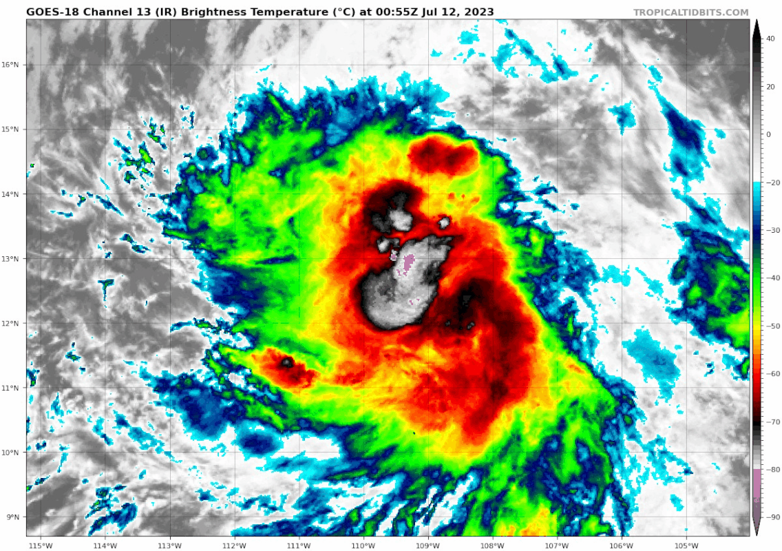
Starting to look kinda shrimpy... could be a sign that it's about to take off. I doubted this at first but it seems like it's getting its act together. Could have some potential to become a nice hurricane, and maybe even the season's first major. Should see an upgrade to Calvin soon I would think, probably at the next advisory.
0 likes
B.S Meteorology, University of Oklahoma '25
Please refer to the NHC, NWS, or SPC for official information.
Please refer to the NHC, NWS, or SPC for official information.
-
ElectricStorm
- Category 5
- Posts: 5154
- Age: 25
- Joined: Tue Aug 13, 2019 11:23 pm
- Location: Norman, OK
Re: EPAC: THREE-E - Tropical Depression - Discussion
UW - CIMSS
ADVANCED DVORAK TECHNIQUE
ADT-Version 9.1
Tropical Cyclone Intensity Algorithm
----- Current Analysis -----
Date : 12 JUL 2023 Time : 051020 UTC
Lat : 12:39:41 N Lon : 109:56:35 W
CI# /Pressure/ Vmax
2.9 /1002.4mb/ 43.0kt
Final T# Adj T# Raw T#
2.9 2.8 3.1
Center Temp : -11.6C Cloud Region Temp : -62.0C
Scene Type : CURVED BAND with 0.79 ARC in LT GRAY
Subtropical Adjustment : OFF
Extratropical Adjustment : OFF
Positioning Method : FORECAST INTERPOLATION
Ocean Basin : EAST PACIFIC
Dvorak CI > MSLP Conversion Used : CKZ Method
Tno/CI Rules : Constraint Limits : 0.7T/6hr
Weakening Flag : OFF
Rapid Dissipation Flag : OFF
C/K/Z MSLP Estimate Inputs :
- Average 34 knot radii : N/A
- Environmental MSLP : 1010mb
Satellite Name : GOES18
Satellite Viewing Angle : 34.5 degrees
0 likes
B.S Meteorology, University of Oklahoma '25
Please refer to the NHC, NWS, or SPC for official information.
Please refer to the NHC, NWS, or SPC for official information.
-
Yellow Evan
- Professional-Met
- Posts: 16257
- Age: 27
- Joined: Fri Jul 15, 2011 12:48 pm
- Location: Henderson, Nevada/Honolulu, HI
- Contact:
Re: EPAC: THREE-E - Tropical Depression - Discussion
TXPZ27 KNES 120628
TCSENP
A. 03E (NONAME)
B. 12/0600Z
C. 12.3N
D. 110.0W
E. THREE/GOES-W
F. T2.0/2.0
G. IR/EIR/SWIR
H. REMARKS...6/10 BANDING RESULTS IN A DT OF 3.0. CONSIDERABLE
ORGANIZATION LAST 6 HR WITH GOOD OUTER BANDING PRESENT AND A NASCENT
CDO. UPR-LVL OUTFLOW RESTRICTED A BIT NE QUAD. MET=1.5 AND PT=2.0. FT
BASED ON PT DUE TO PULSING CONVECTION. SYSTEM MAY BE STRONGER THAN
FT INDICATES.
I. ADDL POSITIONS
NIL
...KONON
0 likes
-
cycloneye
- Admin
- Posts: 149703
- Age: 69
- Joined: Thu Oct 10, 2002 10:54 am
- Location: San Juan, Puerto Rico
Re: EPAC: THREE-E - Tropical Depression - Discussion
EP, 03, 2023071206, , BEST, 0, 124N, 1099W, 35, 1005, TS
0 likes
Visit the Caribbean-Central America Weather Thread where you can find at first post web cams,radars
and observations from Caribbean basin members Click Here
and observations from Caribbean basin members Click Here
-
cycloneye
- Admin
- Posts: 149703
- Age: 69
- Joined: Thu Oct 10, 2002 10:54 am
- Location: San Juan, Puerto Rico
Re: EPAC: CALVIN - Tropical Storm - Discussion
Tropical Storm Calvin Discussion Number 3
NWS National Hurricane Center Miami FL EP032023
300 AM MDT Wed Jul 12 2023
Deep convection associated with the cyclone has continued to become
better organized overnight. There has been a noticeable increase
in banding and the center appears to be located beneath a
developing CDO. Data T-numbers from TAFB and SAB were 2.5 and
3.0, respectively although the final T-number from SAB was lower.
A couple of scatterometer passes shortly before 0600 UTC revealed
winds of 32-34 kt. Based on the continued improvement in
structure since that time and the Dvorak data-T numbers, the
initial intensity is raised to 40 kt for this advisory. Calvin
becomes the third named storm of the 2023 eastern Pacific hurricane
season.
Environmental conditions consisting of light-to-moderate shear,
warm sea surface temperatures, and plentiful low- to mid-level
moisture favor continued intensification of the system during the
next couple of days. Given the fairly small radius of maximum
wind (RMW) noted in the recent scatterometer data and the conducive
environment, steady strengthening is predicted, and Calvin is now
forecast to become a hurricane within 36 hours. It would not be
surprising to see the storm go through a period of rapid
strengthening, however the model guidance is not very bullish on
that scenario. The NHC intensity forecast is near the upper-end of
the guidance, but this could be somewhat conservative. By 72 hours,
Calvin is expected to encounter cooler sea surface temperatures
which is likely to induce gradual weakening during the
remainder of the period.
Calvin is moving westward or 270/14 kt. A strong low- to mid-level
ridge located to the north of Calvin should steer the cyclone
westward during the next several days. After that time, Calvin is
forecast to move westward to west-northwestward to the south of the
ridge. Although the guidance is in good agreement on that overall
scenario, there are some differences in the predicted forward speed
of the cyclone. The updated NHC track forecast lies near the center
of the guidance envelope, close to the various consensus aids to
account for those speed differences.
FORECAST POSITIONS AND MAX WINDS
INIT 12/0900Z 12.4N 110.6W 40 KT 45 MPH
12H 12/1800Z 12.6N 112.8W 45 KT 50 MPH
24H 13/0600Z 12.7N 115.5W 55 KT 65 MPH
36H 13/1800Z 12.9N 118.2W 65 KT 75 MPH
48H 14/0600Z 13.4N 121.1W 70 KT 80 MPH
60H 14/1800Z 14.1N 124.1W 75 KT 85 MPH
72H 15/0600Z 14.7N 127.1W 75 KT 85 MPH
96H 16/0600Z 15.8N 133.3W 65 KT 75 MPH
120H 17/0600Z 16.9N 139.8W 50 KT 60 MPH
$$
Forecaster Brown
0 likes
Visit the Caribbean-Central America Weather Thread where you can find at first post web cams,radars
and observations from Caribbean basin members Click Here
and observations from Caribbean basin members Click Here
Re: EPAC: CALVIN - Tropical Storm - Discussion
Still being affected by NE shear this morning, with a dry slot on its NE quadrant, otherwise it would had taken off rapidly as systems usually do in the EPAC.


0 likes
-
Sciencerocks
- Category 5
- Posts: 10193
- Age: 40
- Joined: Thu Jul 06, 2017 1:51 am

-
cycloneye
- Admin
- Posts: 149703
- Age: 69
- Joined: Thu Oct 10, 2002 10:54 am
- Location: San Juan, Puerto Rico
Re: EPAC: CALVIN - Tropical Storm - Discussion
A. 03E (CALVIN)
B. 12/1200Z
C. 12.5N
D. 111.5W
E. FIVE/GOES-E
F. T2.5/2.5
G. IR/EIR/SWIR
H. REMARKS...5/10 BANDING ON A LOG10 SPIRAL YIELDS A DT OF 2.5. MET IS
A 2.0 DUE TO A DEVELOPING TREND OVER THE LAST 24 HOURS. PT AGREES WITH
DT. THE FT IS BASED ON THE PT DUE TO BANDING FEATURES NOT BEING CLEAR CUT.
I. ADDL POSITIONS
NIL
...NGUYEN
0 likes
Visit the Caribbean-Central America Weather Thread where you can find at first post web cams,radars
and observations from Caribbean basin members Click Here
and observations from Caribbean basin members Click Here
-
wxman57

- Moderator-Pro Met

- Posts: 23175
- Age: 68
- Joined: Sat Jun 21, 2003 8:06 pm
- Location: Houston, TX (southwest)
Re: EPAC: CALVIN - Tropical Storm - Discussion
I plotted Calvin's track over SSTs. The center will be over the warmest water in 36-48 hrs, followed by rapidly declining temperatures beyond 48 hrs. It could easily weaken to a depression by days 4-5 and be nothing more than a naked swirl reaching Hawaii in 7 days.
1 likes
Who is online
Users browsing this forum: No registered users and 67 guests