
CPAC: CALVIN - Post-Tropical - Discussion
Moderator: S2k Moderators
-
Sciencerocks
- Category 5

- Posts: 10193
- Age: 40
- Joined: Thu Jul 06, 2017 1:51 am
-
cycloneye

- Admin

- Posts: 149730
- Age: 69
- Joined: Thu Oct 10, 2002 10:54 am
- Location: San Juan, Puerto Rico
Re: EPAC: CALVIN - Tropical Storm - Discussion
Tropical Storm Calvin Discussion Number 6
NWS National Hurricane Center Miami FL EP032023
500 PM HST Wed Jul 12 2023
Calvin continues to steadily strengthen. A couple microwave passes
from within the past few hours showed that storm had a nearly closed
low-level eye and a mid-level eye open to the northwest. Recent
geostationary satellite imagery suggests the storm's inner core may
have experienced some dry air entrainment from that quadrant.
However, deep convection with over-shooting tops is still present in
the eastern portion of the circulation. Subjective satellite Dvorak
estimates from SAB and TAFB were T4.0/65 kt and T3.5/55 kt,
respectively. The initial intensity has been increased to 60 kt
based on a blend of these estimates.
Atmospheric and oceanic conditions are conducive for additional
strengthening. Calvin is forecast to be in a generally moist
environment, with low vertical wind shear, and warm sea surface
temperatures for the next few days. After 72 h, the SSTs beneath
the storm are expected to gradually cool, while vertical wind shear
increases and mid-level humidity decreases. The combination of
these factors should induce a weakening trend during this portion of
the forecast period. The official intensity prediction is similar
to the previous advisory and is stronger than most of the guidance
due to the potential for rapid intensification in the short-term
forecast.
The storm is moving westward at about 15 kt. A ridge to the north
is steering Calvin at a brisk pace and a west to west-northwest
motion should continue through the end of the forecast period.
There is still notable spread in the model guidance related to the
along-track speed of the cyclone. The NHC track forecast is similar
to the previous advisory and favors the faster model guidance,
falling between the simple and corrected consensus aids.
FORECAST POSITIONS AND MAX WINDS
INIT 13/0300Z 12.6N 114.9W 60 KT 70 MPH
12H 13/1200Z 12.7N 117.0W 70 KT 80 MPH
24H 14/0000Z 13.0N 119.7W 80 KT 90 MPH
36H 14/1200Z 13.7N 122.5W 85 KT 100 MPH
48H 15/0000Z 14.4N 125.4W 85 KT 100 MPH
60H 15/1200Z 15.0N 128.4W 80 KT 90 MPH
72H 16/0000Z 15.6N 131.4W 75 KT 85 MPH
96H 17/0000Z 16.7N 138.0W 60 KT 70 MPH
120H 18/0000Z 17.7N 144.7W 50 KT 60 MPH
$$
Forecaster Bucci
0 likes
Visit the Caribbean-Central America Weather Thread where you can find at first post web cams,radars
and observations from Caribbean basin members Click Here
and observations from Caribbean basin members Click Here
-
Yellow Evan

- Professional-Met

- Posts: 16257
- Age: 27
- Joined: Fri Jul 15, 2011 12:48 pm
- Location: Henderson, Nevada/Honolulu, HI
- Contact:
Re: EPAC: CALVIN - Tropical Storm - Discussion
Shear vector has flipped northerly, causing banding to decrease on the W. This in turn is opening a pathway for dry air to be ingested from the stable air mass to the NW. Moderate shear will likely slow upshear rotation and cause convective asymmetries that will make it more vulnerable to intrusions. The hope is we see gradual organization in the next 24 hours that evolves into a structure that can fend the dry air off, allowing for Calvin to take advantage of a tight window of lower shear to quickly intensify before reaching the 25C isotherm late on Friday.
0 likes
-
cycloneye
- Admin
- Posts: 149730
- Age: 69
- Joined: Thu Oct 10, 2002 10:54 am
- Location: San Juan, Puerto Rico
Re: EPAC: CALVIN - Tropical Storm - Discussion
Tropical Storm Calvin Discussion Number 7
NWS National Hurricane Center Miami FL EP032023
1100 PM HST Wed Jul 12 2023
After a brief pause during the evening, Calvin's organization
appears to be increasing once again. Infrared satellite imagery
shows deep convective bands wrapping around the eastern and
northern portions of the circulation, and very recently the
convection has begun to coil near the center. However, there has
been no recent microwave data to ascertain the current structure of
the inner core. With the earlier pause in organization, subjective
Dvorak estimates are unchanged at T4.0/65 kt from SAB and T3.5/55
kt from TAFB, therefore the initial intensity remains 60 kt, just
below hurricane strength.
Calvin is likely to become a hurricane soon as strengthening should
resume as the storm remains within conducive atmospheric and
oceanic conditions. The latest NHC intensity forecast calls for a
similar peak intensity as before. After 36 hours, sea surface
temperatures will gradually cool along the track of Calvin and
mid-level moisture is also predicted to decrease. Those less
favorable conditions are likely to induce gradual weakening during
the remainder of the forecast period. The latest NHC wind speed
forecast is close to the SHIPS intensity guidance in the short term,
but follows a blend of the HFIP-corrected consensus
model and the IVCN multi-model consensus aid thereafter.
Calvin continues to move westward but at a slightly slower forward
speed of around 13 kt. A strong mid-level ridge to the north of the
cyclone should continue to steer it westward to west-northwestward
throughout the forecast period. The cross-track spread of the
guidance continues to be small but there is still notable
along-track spread (forward speed differences) in the dynamical
models. The NHC track forecast lies between the faster
HFIP-corrected consensus model and the slower consensus aids.
FORECAST POSITIONS AND MAX WINDS
INIT 13/0900Z 12.4N 116.0W 60 KT 70 MPH
12H 13/1800Z 12.7N 118.2W 70 KT 80 MPH
24H 14/0600Z 13.2N 121.0W 80 KT 90 MPH
36H 14/1800Z 13.8N 123.8W 85 KT 100 MPH
48H 15/0600Z 14.4N 126.7W 80 KT 90 MPH
60H 15/1800Z 15.0N 129.6W 75 KT 85 MPH
72H 16/0600Z 15.7N 132.6W 70 KT 80 MPH
96H 17/0600Z 16.8N 138.9W 55 KT 65 MPH
120H 18/0600Z 17.7N 145.7W 45 KT 50 MPH
$$
Forecaster Brown
0 likes
Visit the Caribbean-Central America Weather Thread where you can find at first post web cams,radars
and observations from Caribbean basin members Click Here
and observations from Caribbean basin members Click Here
-
Kingarabian

- S2K Supporter

- Posts: 16379
- Joined: Sat Aug 08, 2009 3:06 am
- Location: Honolulu, Hawaii
Re: EPAC: CALVIN - Tropical Storm - Discussion
That is a dry slot but microwave clearly supports a hurricane.
0 likes
RIP Kobe Bryant
-
cycloneye
- Admin
- Posts: 149730
- Age: 69
- Joined: Thu Oct 10, 2002 10:54 am
- Location: San Juan, Puerto Rico
Re: EPAC: CALVIN - Tropical Storm - Discussion
A. 03E (CALVIN)
B. 13/1200Z
C. 12.5N
D. 116.3W
E. THREE/GOES-W
F. T4.0/4.0
G. IR/EIR/SWIR
H. REMARKS...13/10 BANDING RESULTS IN A DT OF 4.0. THE MET IS 3.5 AND
THE PT IS 4.0. THE FT IS BASED ON THE DT.
I. ADDL POSITIONS
NIL
...BROWN
B. 13/1200Z
C. 12.5N
D. 116.3W
E. THREE/GOES-W
F. T4.0/4.0
G. IR/EIR/SWIR
H. REMARKS...13/10 BANDING RESULTS IN A DT OF 4.0. THE MET IS 3.5 AND
THE PT IS 4.0. THE FT IS BASED ON THE DT.
I. ADDL POSITIONS
NIL
...BROWN
0 likes
Visit the Caribbean-Central America Weather Thread where you can find at first post web cams,radars
and observations from Caribbean basin members Click Here
and observations from Caribbean basin members Click Here
-
cycloneye
- Admin
- Posts: 149730
- Age: 69
- Joined: Thu Oct 10, 2002 10:54 am
- Location: San Juan, Puerto Rico
Re: EPAC: CALVIN - Tropical Storm - Discussion
EP, 03, 2023071312, , BEST, 0, 126N, 1164W, 65, 993, HU
0 likes
Visit the Caribbean-Central America Weather Thread where you can find at first post web cams,radars
and observations from Caribbean basin members Click Here
and observations from Caribbean basin members Click Here
-
Sciencerocks
- Category 5
- Posts: 10193
- Age: 40
- Joined: Thu Jul 06, 2017 1:51 am


Re: EPAC: CALVIN - Tropical Storm - Discussion
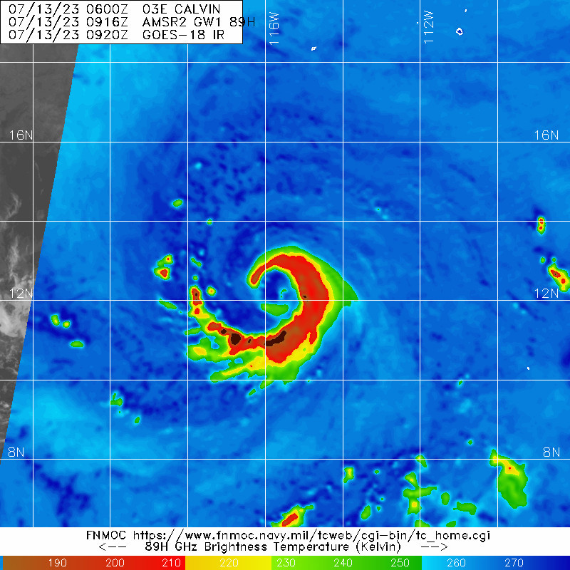
It looks great on satellite this morning but can’t fully shake off that dry slot, the Euro has done a great job of showing it days ago.

0 likes
-
cycloneye
- Admin
- Posts: 149730
- Age: 69
- Joined: Thu Oct 10, 2002 10:54 am
- Location: San Juan, Puerto Rico
Re: EPAC: CALVIN - Hurricane - Discussion
Hurricane Calvin Discussion Number 8
NWS National Hurricane Center Miami FL EP032023
500 AM HST Thu Jul 13 2023
Infrared and proxy-visible satellite imagery shows deep and wide
convective bands wrapping around Calvin's center this morning.
Recent AMSR and SSMIS microwave passes show that the system has a
well-defined inner core, and an eyewall is forming but is not
completely closed. The upper-level outflow wind pattern on the
eastern side of the system has improved as well. Dvorak estimates
for this advisory were T4.0/65 kt from both SAB and TAFB. Given
these estimates and improved satellite trends, the initial
intensity is set to 65 kt for this advisory. This makes Calvin the
third hurricane of the Eastern Pacific hurricane season.
The hurricane remains within a conducive environment for additional
strengthening to occur with low vertical wind shear and warm SSTs.
The peak intensity of 85 kt in 36 hours remains unchanged from the
previous NHC forecast. After 36 hours, sea surface temperatures
along the track of Calvin will gradually begin to cool, and this
will likely induce gradual weakening through the remainder of the
forecast period. The latest NHC intensity forecast lies near the
upper-end of the guidance in the near-term, closest to HCCA, and
then shows gradual weakening commensurate with the model consensus
towards the end of the period.
Calvin continues to move westward but at a slightly slower forward
speed of around 11 kt. A strong mid-level ridge to the north of
Calvin will continue to move the system westward to
west-northwestward. The cross-track spread continues to be fairly
low, with the main difference in the models being Calvin's
future forward speed. The NHC track forecast lies between the
faster HCCA model and the slower consensus and global model
guidance, and is not too different from the previous forecast.
FORECAST POSITIONS AND MAX WINDS
INIT 13/1500Z 12.7N 117.1W 65 KT 75 MPH
12H 14/0000Z 13.0N 119.2W 75 KT 85 MPH
24H 14/1200Z 13.5N 122.1W 80 KT 90 MPH
36H 15/0000Z 14.1N 124.9W 85 KT 100 MPH
48H 15/1200Z 14.7N 127.8W 80 KT 90 MPH
60H 16/0000Z 15.3N 130.8W 75 KT 85 MPH
72H 16/1200Z 16.0N 133.9W 70 KT 80 MPH
96H 17/1200Z 17.0N 140.4W 55 KT 65 MPH
120H 18/1200Z 17.9N 147.6W 45 KT 50 MPH
$$
Forecaster Kelly/Berg
0 likes
Visit the Caribbean-Central America Weather Thread where you can find at first post web cams,radars
and observations from Caribbean basin members Click Here
and observations from Caribbean basin members Click Here
-
wxman57

- Moderator-Pro Met

- Posts: 23175
- Age: 68
- Joined: Sat Jun 21, 2003 8:06 pm
- Location: Houston, TX (southwest)
Re: EPAC: CALVIN - Hurricane - Discussion
I think that Calvin will be weakening faster than the NHC is predicting. It's about to start moving over cooler water already. By day 5, I have it as a remnant low vs. a 45 kt TS. Probably no convection by then.
0 likes
-
Kingarabian
- S2K Supporter
- Posts: 16379
- Joined: Sat Aug 08, 2009 3:06 am
- Location: Honolulu, Hawaii
Re: EPAC: CALVIN - Hurricane - Discussion
wxman57 wrote:I think that Calvin will be weakening faster than the NHC is predicting. It's about to start moving over cooler water already. By day 5, I have it as a remnant low vs. a 45 kt TS. Probably no convection by then.
I agree so long as the current structure remains. Needs to lose the banding and shear needs some sort of easterly component for it to survive longer over marginal waters.
0 likes
RIP Kobe Bryant
-
Sciencerocks
- Category 5
- Posts: 10193
- Age: 40
- Joined: Thu Jul 06, 2017 1:51 am

-
cycloneye
- Admin
- Posts: 149730
- Age: 69
- Joined: Thu Oct 10, 2002 10:54 am
- Location: San Juan, Puerto Rico
Re: EPAC: CALVIN - Hurricane - Discussion
EP, 03, 2023071318, , BEST, 0, 127N, 1180W, 70, 990, HU
0 likes
Visit the Caribbean-Central America Weather Thread where you can find at first post web cams,radars
and observations from Caribbean basin members Click Here
and observations from Caribbean basin members Click Here
-
Yellow Evan
- Professional-Met
- Posts: 16257
- Age: 27
- Joined: Fri Jul 15, 2011 12:48 pm
- Location: Henderson, Nevada/Honolulu, HI
- Contact:
Re: EPAC: CALVIN - Hurricane - Discussion
TXPZ27 KNES 131823
TCSENP
A. 03E (CALVIN)
B. 13/1800Z
C. 12.7N
D. 118.0W
E. THREE/GOES-W
F. T4.0/4.0
G. IR/EIR/VIS
H. REMARKS...13/10 BANDING RESULTS IN A DT OF 4.0. THE MET AND PT BOTH
AGREE. THE FT IS BASED ON THE DT.
I. ADDL POSITIONS
NIL
...BROWN
TCSENP
A. 03E (CALVIN)
B. 13/1800Z
C. 12.7N
D. 118.0W
E. THREE/GOES-W
F. T4.0/4.0
G. IR/EIR/VIS
H. REMARKS...13/10 BANDING RESULTS IN A DT OF 4.0. THE MET AND PT BOTH
AGREE. THE FT IS BASED ON THE DT.
I. ADDL POSITIONS
NIL
...BROWN
0 likes
-
ElectricStorm

- Category 5
- Posts: 5156
- Age: 25
- Joined: Tue Aug 13, 2019 11:23 pm
- Location: Norman, OK
Re: EPAC: CALVIN - Hurricane - Discussion
Still a dry slot there but duel towers wrapping around the center now. Maybe that can help finally mix it out
0 likes
B.S Meteorology, University of Oklahoma '25
Please refer to the NHC, NWS, or SPC for official information.
Please refer to the NHC, NWS, or SPC for official information.
-
cycloneye
- Admin
- Posts: 149730
- Age: 69
- Joined: Thu Oct 10, 2002 10:54 am
- Location: San Juan, Puerto Rico
Re: EPAC: CALVIN - Hurricane - Discussion
Hurricane Calvin Discussion Number 9
NWS National Hurricane Center Miami FL EP032023
1100 AM HST Thu Jul 13 2023
High-resolution 1-minute visible satellite imagery shows the inner
core of Calvin becoming better defined with deep convective banding
wrapping around the center. In the past hour or so, satellite
trends show what may be the beginning stages of eye trying to
develop, and this would be in agreement with what was reflected in
microwaves passes from earlier this morning. The upper-level outflow
wind pattern has continued to become better established around the
cyclone as well. Subjective satellite Dvorak estimates were T4.0/65
kt and T4.5/77 kt from SAB and TAFB, respectively. Given the
improved satellite structure and a blend of the subjective intensity
estimates, the initial intensity is set to 70 kt for this advisory.
The cyclone continues to be over warm sea surface temperatures
and within a low vertical wind shear environment, with gradual
strengthening forecast for the next day or so. The forecast peak
intensity remains 85 kt in 24-36 hours. However, there was some
model guidance this cycle, particularly HCCA, that showed the
potential for the system to become a little bit stronger than that.
After 36 hours, sea surface temperatures along the track of Calvin
will gradually begin to cool, and this will likely induce gradual
weakening through the remainder of the forecast period. The latest
NHC intensity forecast lies near the upper-end of the guidance in
the short term, then shows gradual weakening, and is near the
consensus aids by the end of the period.
Calvin is moving westward at 275/12 kt. A strong mid-level ridge to
the north of Calvin will continue to move the system westward to
west-northwestward. The track guidance continues to be in fairly
good agreement, with the consensus aids and HCCA coming into better
agreement with the forward speed compared to previous model cycles.
The NHC track forecast is not too different from the previous
forecast.
FORECAST POSITIONS AND MAX WINDS
INIT 13/2100Z 12.8N 118.7W 70 KT 80 MPH
12H 14/0600Z 13.2N 120.8W 80 KT 90 MPH
24H 14/1800Z 13.7N 123.7W 85 KT 100 MPH
36H 15/0600Z 14.3N 126.5W 85 KT 100 MPH
48H 15/1800Z 14.9N 129.4W 80 KT 90 MPH
60H 16/0600Z 15.6N 132.3W 75 KT 85 MPH
72H 16/1800Z 16.2N 135.2W 65 KT 75 MPH
96H 17/1800Z 17.3N 141.9W 50 KT 60 MPH
120H 18/1800Z 18.2N 149.1W 40 KT 45 MPH
$$
Forecaster Kelly/Berg
0 likes
Visit the Caribbean-Central America Weather Thread where you can find at first post web cams,radars
and observations from Caribbean basin members Click Here
and observations from Caribbean basin members Click Here
-
Hurricane2022

- Category 5
- Posts: 2093
- Joined: Tue Aug 23, 2022 11:38 pm
- Location: Araçatuba, Brazil
Re: EPAC: CALVIN - Hurricane - Discussion
0 likes
Sorry for the bad English sometimes...!
For reliable and detailed information for any meteorological phenomenon, please consult the National Hurricane Center, Joint Typhoon Warning Center , or your local Meteo Center.
--------
ECCE OMNIA NOVA FACIAM (Ap 21,5).
For reliable and detailed information for any meteorological phenomenon, please consult the National Hurricane Center, Joint Typhoon Warning Center , or your local Meteo Center.
--------
ECCE OMNIA NOVA FACIAM (Ap 21,5).
Re: EPAC: CALVIN - Hurricane - Discussion
Looking much better. Could definitely get to at least Cat 2 before moving over cooler SSTs.

0 likes
-
Sciencerocks
- Category 5
- Posts: 10193
- Age: 40
- Joined: Thu Jul 06, 2017 1:51 am

Who is online
Users browsing this forum: No registered users and 34 guests