2023 Global Model Runs Discussion (Out thru day 16)

This is the general tropical discussion area. Anyone can take their shot at predicting a storms path.

Moderator: S2k Moderators

Forum rules

The posts in this forum are NOT official forecasts and should not be used as such. They are just the opinion of the poster and may or may not be backed by sound meteorological data. They are NOT endorsed by any professional institution or STORM2K. For official information, please refer to products from the National Hurricane Center and National Weather Service.

Help Support Storm2K
Message
Author
User avatar
chaser1
S2K Supporter
S2K Supporter
Posts: 5464
Age: 64
Joined: Sat Oct 15, 2005 5:59 pm
Location: Longwood, Fl

Re: 2023 Global Model Runs Discussion (Out thru day 16)

#381 Postby chaser1 » Sun Jul 16, 2023 10:10 am


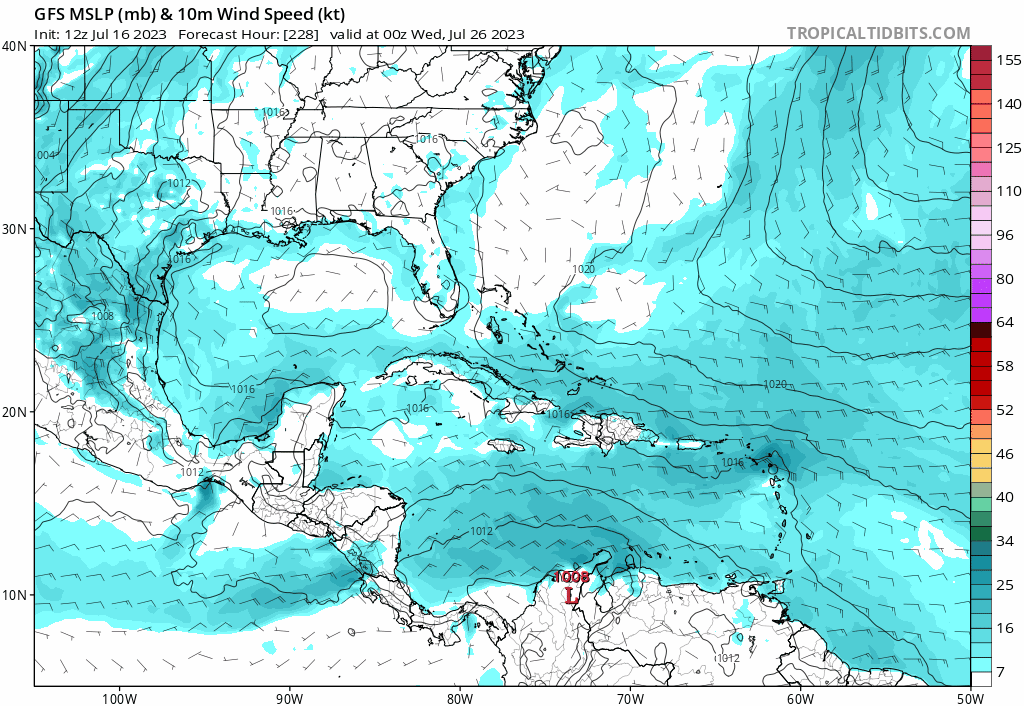
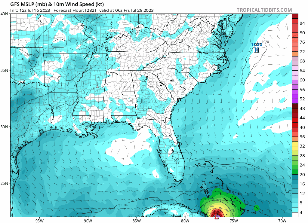
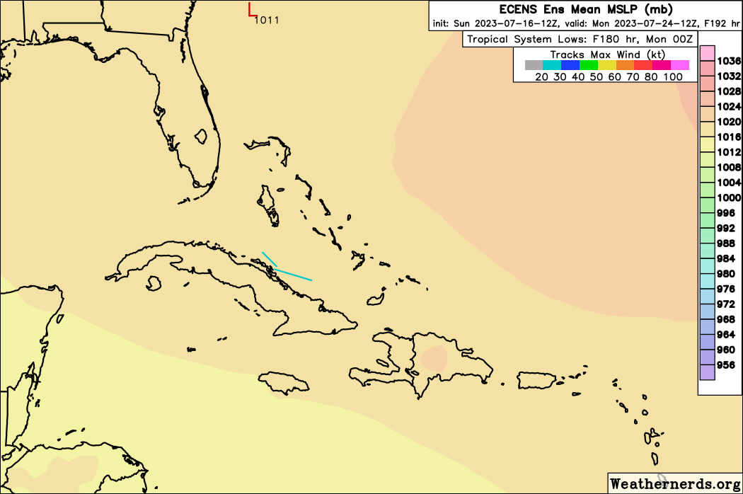
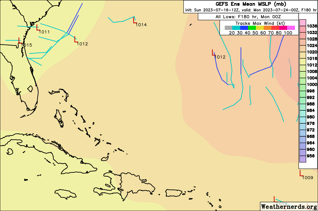
An interesting benchmark to watch and see whether the number of model members maintain, decrease or increase the potential of development. I myself consider the EPS run a tad less worrisome than it might appear for one particular reason. Discounting the two members over South/Central America, that leaves 16 model members with reported 240 hr surface pressures. If one were to eliminate all members depicting 1010 mb pressures or higher, that would then leave only 8 members remaining. Using that metric, it will be interesting to compare subsequent forecasts. Thats not to say that a westward advancing tropical wave with 1012-1014 mb surface pressures can't suddenly find a "sweet spot" nearing the Greater Antilles or Bahamas but future model runs will then bear this threat out with any consistent run-to-run uptick.
3 likes   
Andy D

(For official information, please refer to the NHC and NWS products.)

User avatar
tiger_deF
Category 1
Category 1
Posts: 468
Age: 24
Joined: Tue Sep 27, 2016 11:47 am

Re: 2023 Global Model Runs Discussion (Out thru day 16)

#382 Postby tiger_deF » Sun Jul 16, 2023 11:17 am

I don't think the OP GFS has a great handle on the potential system evolution. The 12z run keeps trying to deepen the current tropical wave in the open Atlantic, which our emerging waves runs into resulting in all kind of convective weirdness.
0 likes   

User avatar
Blown Away
S2K Supporter
S2K Supporter
Posts: 10145
Joined: Wed May 26, 2004 6:17 am

Re: 2023 Global Model Runs Discussion (Out thru day 16)

#383 Postby Blown Away » Sun Jul 16, 2023 11:47 am

Image[/url]
12z GFS deepening a system in SW Atlantic bringing a strong Cat 2/3 into Key West then EGOM… Those SST’s :eek:
Last edited by Blown Away on Sun Jul 16, 2023 12:03 pm, edited 1 time in total.
2 likes   
Hurricane Eye Experience: David 79, Irene 99, Frances 04, Jeanne 04, Wilma 05... EYE COMING MY WAY IN 2024…
Hurricane Brush Experience: Andrew 92, Erin 95, Floyd 99, Matthew 16, Irma 17, Ian 22, Nicole 22…

User avatar
Kingarabian
S2K Supporter
S2K Supporter
Posts: 15980
Joined: Sat Aug 08, 2009 3:06 am
Location: Honolulu, Hawaii

Re: 2023 Global Model Runs Discussion (Out thru day 16)

#384 Postby Kingarabian » Sun Jul 16, 2023 11:56 am

Blown Away wrote:[url]https://i.postimg.cc/Zn54hrzj/gfs-mslp-wind-watl-fh228-306.gif [/url]
12z GFS deepening a system in SW Atlantic… :eek:

If that gets into the GOM it'll be a MH no doubt. Models showing virtually no shear at that time frame.
2 likes   
RIP Kobe Bryant

User avatar
Blown Away
S2K Supporter
S2K Supporter
Posts: 10145
Joined: Wed May 26, 2004 6:17 am

Re: 2023 Global Model Runs Discussion (Out thru day 16)

#385 Postby Blown Away » Sun Jul 16, 2023 12:08 pm

Image

12z GFS… Crosses Key West then into EGOM… Wow perfect track to absorb those insane SST’s in Keys and EGOM, probably a hair E of Loop current… Finishes moving towards FL Panhandle… Only 1 run and very long range…
Last edited by Blown Away on Sun Jul 16, 2023 12:37 pm, edited 1 time in total.
3 likes   
Hurricane Eye Experience: David 79, Irene 99, Frances 04, Jeanne 04, Wilma 05... EYE COMING MY WAY IN 2024…
Hurricane Brush Experience: Andrew 92, Erin 95, Floyd 99, Matthew 16, Irma 17, Ian 22, Nicole 22…

User avatar
Category5Kaiju
Category 5
Category 5
Posts: 4097
Joined: Thu Dec 24, 2020 12:45 pm
Location: Seattle

Re: 2023 Global Model Runs Discussion (Out thru day 16)

#386 Postby Category5Kaiju » Sun Jul 16, 2023 12:21 pm

Just watched that last GFS run...

Image
3 likes   
Unless explicitly stated, all info in my posts is based on my own opinions and observations. Tropical storms and hurricanes can be extremely dangerous. Do not think you can beat Mother Nature. Refer to an accredited weather research agency or meteorologist if you need to make serious decisions regarding an approaching storm.

BobHarlem
Category 5
Category 5
Posts: 2106
Joined: Thu Oct 20, 2005 6:11 pm

Re: 2023 Global Model Runs Discussion (Out thru day 16)

#387 Postby BobHarlem » Sun Jul 16, 2023 12:25 pm

The water temps around Andros island and Key West are crazy hot, if that GFS path is correct, I think it would be underestimating intensity quite a bit. It'll be interesting to see if the Euro picks up on this, but really the GFS doesn't do anything with it until the fantasy range, beyond the EURO timeframe, so those aren't a great match right now. However CMC takes the system into the Caribbean, and the 0z Euro was much weaker, although some of the ensembles were coming around. Something to keep a close watch on next week either way, it seems. At least this is out in fantasy GFS range now.
Last edited by BobHarlem on Sun Jul 16, 2023 1:37 pm, edited 1 time in total.
2 likes   

User avatar
Spacecoast
Category 2
Category 2
Posts: 758
Joined: Thu Aug 31, 2017 2:03 pm

Re: 2023 Global Model Runs Discussion (Out thru day 16)

#388 Postby Spacecoast » Sun Jul 16, 2023 12:48 pm

12z GEFS finds some room to curve earlier than Operational...
Image
Last edited by Spacecoast on Sun Jul 16, 2023 1:05 pm, edited 2 times in total.
1 likes   

User avatar
ElectricStorm
Category 5
Category 5
Posts: 5044
Age: 24
Joined: Tue Aug 13, 2019 11:23 pm
Location: Skiatook, OK / Norman, OK

Re: 2023 Global Model Runs Discussion (Out thru day 16)

#389 Postby ElectricStorm » Sun Jul 16, 2023 12:51 pm

Probably just the typical 300+ hour GFS shenanigans at this point, and will likely be gone by the next run.

This wave could have a decent chance at some sort of development though so it needs to be watched but I'm not buying this run for now.
0 likes   
B.S Meteorology, University of Oklahoma '25

Please refer to the NHC, NWS, or SPC for official information.

User avatar
cainjamin
Tropical Storm
Tropical Storm
Posts: 168
Age: 34
Joined: Mon Apr 17, 2017 1:38 pm
Location: Nova Scotia, Canada

Re: 2023 Global Model Runs Discussion (Out thru day 16)

#390 Postby cainjamin » Sun Jul 16, 2023 12:57 pm

While the 12z GFS is likely overdone on intensity, more and more models are coming on board to at least some slight development of this wave. Wouldn't be shocked to get a short-lived depression or storm out of it.
0 likes   
Noel '07, Kyle '08, Earl '10, Arthur '14, Dorian '19, Teddy '20, Lee '23

User avatar
JetFuel_SE
Category 1
Category 1
Posts: 282
Age: 25
Joined: Thu Apr 30, 2020 3:57 pm

Re: 2023 Global Model Runs Discussion (Out thru day 16)

#391 Postby JetFuel_SE » Sun Jul 16, 2023 1:05 pm

ElectricStorm wrote:Probably just the typical 300+ hour GFS shenanigans at this point, and will likely be gone by the next run.

This wave could have a decent chance at some sort of development though so it needs to be watched but I'm not buying this run for now.

It's been showing some development of this wave for quite a while now, and just as other models also start picking up on it, the GFS shows a strong system.
0 likes   

USTropics
Professional-Met
Professional-Met
Posts: 2651
Joined: Sun Aug 12, 2007 3:45 am
Location: Florida State University

Re: 2023 Global Model Runs Discussion (Out thru day 16)

#392 Postby USTropics » Sun Jul 16, 2023 1:53 pm

Just looking at the medium range (~5 days), the GFS solution is definitely possible, albeit there are a lot of moving parts. For one, Don's location and strength in 3-5 days plays a pivotal role in breaking down the eastern periphery of the BH, which significantly slows down the westward progression of the current wave in the eastern ATL. Of this, the majority of the model guidance is in agreement with:
Image

Also notice in the 06z surface analysis a low pressure was initialized over NW Africa (red L). The GFS has a piece of this energy being ejected along the monsoon trough axis (red dash) and interacting with a future wave axis. This then coalesces with the EATL wave and remains weak until reaching the NW Caribbean. Also the convective complex over the CATL is not associated with the far eastern Atlantic wave axis (this is currently mostly devoid of
deep convection and highlighted in pink):
Image

This is the full evolution of the GFS through 5 days:
Image

We can see from the 06z ECMWF ensembles and 12z GFS ensembles there remains a wide spread on where this could potentially coalesce at:
Image

Image
8 likes   

User avatar
cycloneye
Admin
Admin
Posts: 145303
Age: 68
Joined: Thu Oct 10, 2002 10:54 am
Location: San Juan, Puerto Rico

Re: 2023 Global Model Runs Discussion (Out thru day 16)

#393 Postby cycloneye » Sun Jul 16, 2023 1:59 pm

I am surprised our NWS posted this message on twitter with a good deal of time ahead.

 https://twitter.com/NWSSanJuan/status/1680645411906949120


@NWSSanJuan
[ Jul 16 ] Although with much uncertainty, global models suggest the development of a tropical cyclone that could reach the northeastern Caribbean early next week. Stay tuned for forecast updates! #PRwx #USVIwx
0 likes   
Visit the Caribbean-Central America Weather Thread where you can find at first post web cams,radars
and observations from Caribbean basin members Click Here

User avatar
cycloneye
Admin
Admin
Posts: 145303
Age: 68
Joined: Thu Oct 10, 2002 10:54 am
Location: San Juan, Puerto Rico

Re: 2023 Global Model Runs Discussion (Out thru day 16)

#394 Postby cycloneye » Sun Jul 16, 2023 2:14 pm

12z Euro operational has it but moves west without developing. Look near Guadeloupe.

Image
0 likes   
Visit the Caribbean-Central America Weather Thread where you can find at first post web cams,radars
and observations from Caribbean basin members Click Here

User avatar
Teban54
Category 5
Category 5
Posts: 3204
Joined: Sat May 19, 2018 1:19 pm

Re: 2023 Global Model Runs Discussion (Out thru day 16)

#395 Postby Teban54 » Sun Jul 16, 2023 2:25 pm

Just a day ago, the Twitter mets were saying forecast for an active season may bust because the Atlantic can't take advantage of a CCKW in July.

Funny how things can change in just 24 hours.
3 likes   

User avatar
Blown Away
S2K Supporter
S2K Supporter
Posts: 10145
Joined: Wed May 26, 2004 6:17 am

Re: 2023 Global Model Runs Discussion (Out thru day 16)

#396 Postby Blown Away » Sun Jul 16, 2023 2:47 pm

Image

12z ECENS… A bit quieter than 00z…
Last edited by Blown Away on Sun Jul 16, 2023 2:54 pm, edited 2 times in total.
1 likes   
Hurricane Eye Experience: David 79, Irene 99, Frances 04, Jeanne 04, Wilma 05... EYE COMING MY WAY IN 2024…
Hurricane Brush Experience: Andrew 92, Erin 95, Floyd 99, Matthew 16, Irma 17, Ian 22, Nicole 22…

User avatar
Spacecoast
Category 2
Category 2
Posts: 758
Joined: Thu Aug 31, 2017 2:03 pm

Re: 2023 Global Model Runs Discussion (Out thru day 16)

#397 Postby Spacecoast » Sun Jul 16, 2023 2:50 pm

Blown Away wrote:[url]https://i.postimg.cc/3wms4Q40/68815451.gif [/url]post a picture

12z ECENS… Worth :eek: ATM


Here's 12z ECENS probability -Day 10
TD Probability ~15%
Image
TS Probability ~10%
Image
Hurricane Probability is back to 0%....
0 likes   

User avatar
Blown Away
S2K Supporter
S2K Supporter
Posts: 10145
Joined: Wed May 26, 2004 6:17 am

Re: 2023 Global Model Runs Discussion (Out thru day 16)

#398 Postby Blown Away » Sun Jul 16, 2023 4:35 pm

Image
12z GEFS
0 likes   
Hurricane Eye Experience: David 79, Irene 99, Frances 04, Jeanne 04, Wilma 05... EYE COMING MY WAY IN 2024…
Hurricane Brush Experience: Andrew 92, Erin 95, Floyd 99, Matthew 16, Irma 17, Ian 22, Nicole 22…

ChrisH-UK
Category 2
Category 2
Posts: 625
Joined: Sat May 29, 2021 8:22 am

Re: 2023 Global Model Runs Discussion (Out thru day 16)

#399 Postby ChrisH-UK » Sun Jul 16, 2023 4:50 pm

The hi res also shows it approaching the Caribbean at 180 hours out. The Atlantic is waking up after it's nap.

Source - https://charts.ecmwf.int/permalinks/vor ... vels-96132

Image
0 likes   

User avatar
wxman57
Moderator-Pro Met
Moderator-Pro Met
Posts: 22978
Age: 67
Joined: Sat Jun 21, 2003 8:06 pm
Location: Houston, TX (southwest)

Re: 2023 Global Model Runs Discussion (Out thru day 16)

#400 Postby wxman57 » Sun Jul 16, 2023 5:00 pm

12Z GFS = BS. Don't believe it for a second. Once again, it's all alone in forecasting a hurricane. Just a wave moving across the NE Caribbean next Tue/Wed, causing a bit of rain is most likely. Euro barely has any 850mb vorticity at all. Canadian has a much stronger ridge to the north, pushing the wave to Central America in about 12 days.
2 likes   


Return to “Talkin' Tropics”

Who is online

Users browsing this forum: Kingarabian, USTropics and 42 guests