
2023 Global Model Runs Discussion (Out thru day 16)
Moderator: S2k Moderators
Forum rules

The posts in this forum are NOT official forecasts and should not be used as such. They are just the opinion of the poster and may or may not be backed by sound meteorological data. They are NOT endorsed by any professional institution or STORM2K. For official information, please refer to products from the National Hurricane Center and National Weather Service.
Re: 2023 Global Model Runs Discussion (Out thru day 16)
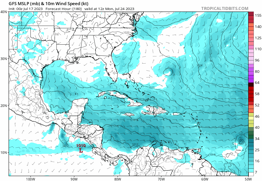
18z GFS is a bit south so far, and gets into HIspianola (out to 240 hours)
0 likes
-
Blown Away

- S2K Supporter

- Posts: 10253
- Joined: Wed May 26, 2004 6:17 am
Re: 2023 Global Model Runs Discussion (Out thru day 16)
BobHarlem wrote:18z GFS is a bit south so far, and gets into HIspianola (out to 240 hours)
https://i.imgur.com/x2xCSxv.png
18z GFS Likely would have been a hurricane if just N or S of Hispaniola… Let’s see what it looks like after land…
0 likes
Hurricane Eye Experience: David 79, Irene 99, Frances 04, Jeanne 04, Wilma 05… Hurricane Brush Experience: Andrew 92, Erin 95, Floyd 99, Matthew 16, Irma 17, Ian 22, Nicole 22…
Re: 2023 Global Model Runs Discussion (Out thru day 16)
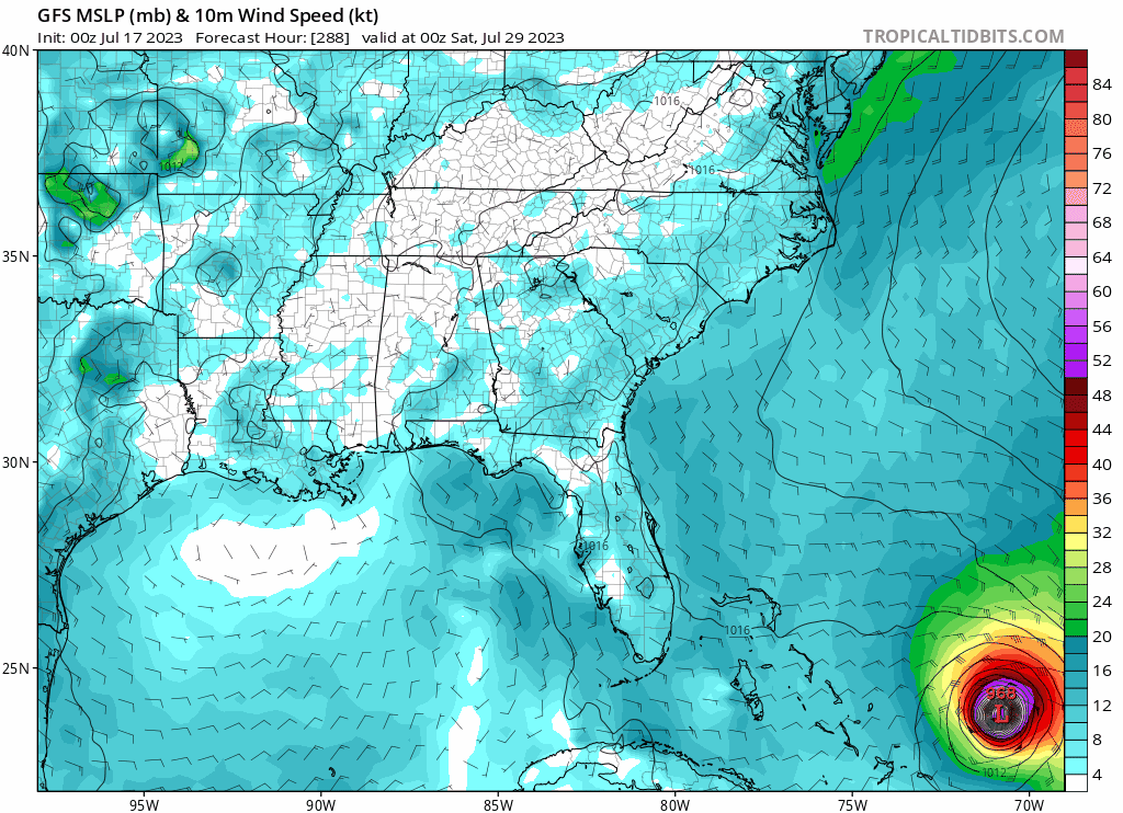
Back into the Gulf.

GFS is a bit too far out right now, and it really depends if it can get its act together before it gets toward the Caribbean, mid level dry air is going to be the main counter for this one, which I think is what the Euro is leaning toward, and that really is probably more likely at this point.
This run heads up to Mississippi, way too far out to believe right now.
1 likes
-
Blown Away
- S2K Supporter
- Posts: 10253
- Joined: Wed May 26, 2004 6:17 am
Re: 2023 Global Model Runs Discussion (Out thru day 16)
00z Euro hinted at TS development and 12z backed off. GFS 12z & 18z showing a potent system into NE Caribbean and into GOM. If NHC buys this the 7 day lemon should be in the Central Atlantic soon b/c GFS says development starts in 6-7 days…
0 likes
Hurricane Eye Experience: David 79, Irene 99, Frances 04, Jeanne 04, Wilma 05… Hurricane Brush Experience: Andrew 92, Erin 95, Floyd 99, Matthew 16, Irma 17, Ian 22, Nicole 22…
-
Blown Away
- S2K Supporter
- Posts: 10253
- Joined: Wed May 26, 2004 6:17 am
Re: 2023 Global Model Runs Discussion (Out thru day 16)
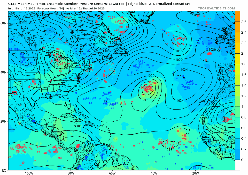
18z GEFS… Most active so far with development.
0 likes
Hurricane Eye Experience: David 79, Irene 99, Frances 04, Jeanne 04, Wilma 05… Hurricane Brush Experience: Andrew 92, Erin 95, Floyd 99, Matthew 16, Irma 17, Ian 22, Nicole 22…
-
Spacecoast

- Category 2

- Posts: 773
- Joined: Thu Aug 31, 2017 2:03 pm
Re: 2023 Global Model Runs Discussion (Out thru day 16)
Blown Away wrote:[url]https://i.postimg.cc/4xYJDXbt/gfs-ememb-lowlocs-atl-fh90-318.gif [/url]
18z GEFS… Most active so far with development.
4 members (20%) show hurricane days 8-15
1 of those members (5%) gets MH into gulf. Shows 933mb (Cat4?) into La day 15
1 likes
-
Blown Away
- S2K Supporter
- Posts: 10253
- Joined: Wed May 26, 2004 6:17 am
Re: 2023 Global Model Runs Discussion (Out thru day 16)
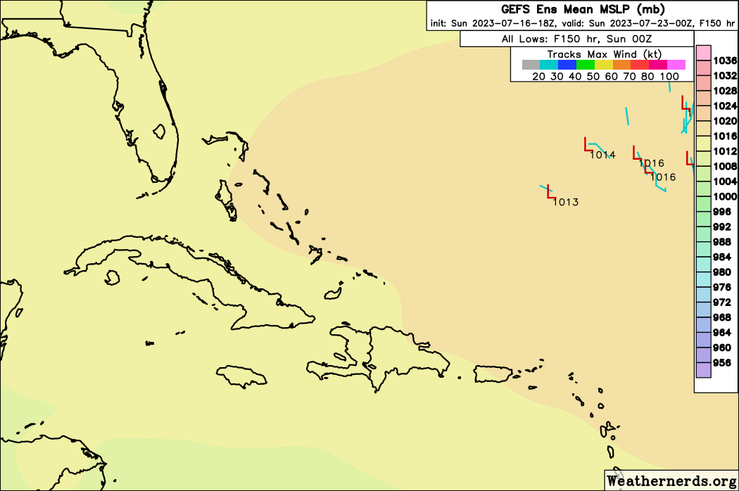
18z GEFS
0 likes
Hurricane Eye Experience: David 79, Irene 99, Frances 04, Jeanne 04, Wilma 05… Hurricane Brush Experience: Andrew 92, Erin 95, Floyd 99, Matthew 16, Irma 17, Ian 22, Nicole 22…
-
Blown Away
- S2K Supporter
- Posts: 10253
- Joined: Wed May 26, 2004 6:17 am
Re: 2023 Global Model Runs Discussion (Out thru day 16)
00z GFS… Much stronger with strong TS/Hurricane into NE Caribbean @9 days…
1 likes
Hurricane Eye Experience: David 79, Irene 99, Frances 04, Jeanne 04, Wilma 05… Hurricane Brush Experience: Andrew 92, Erin 95, Floyd 99, Matthew 16, Irma 17, Ian 22, Nicole 22…
-
SFLcane

- S2K Supporter
- Posts: 10281
- Age: 48
- Joined: Sat Jun 05, 2010 1:44 pm
- Location: Lake Worth Florida
Re: 2023 Global Model Runs Discussion (Out thru day 16)
Surely don’t like the look of this pattern! 
2 likes
-
Category5Kaiju

- Category 5

- Posts: 4334
- Joined: Thu Dec 24, 2020 12:45 pm
- Location: Seattle and Phoenix
Re: 2023 Global Model Runs Discussion (Out thru day 16)
Nothing remarkable to look at on the recent GFS, future Emily is just trying its best to mimic a storm from 2019… 
3 likes
Unless explicitly stated, all info in my posts is based on my own opinions and observations. Tropical storms and hurricanes can be extremely dangerous. Refer to an accredited weather research agency or meteorologist if you need to make serious decisions regarding an approaching storm.
-
ElectricStorm

- Category 5
- Posts: 5147
- Age: 25
- Joined: Tue Aug 13, 2019 11:23 pm
- Location: Norman, OK
Re: 2023 Global Model Runs Discussion (Out thru day 16)
No lemon on the newest TWO but I'd imagine we'll see one pretty soon for this wave. If it can develop in the MDR before it reaches the islands, that would be the third TC to do that already this season. The last time 3 TCs formed east of the islands in the MDR before August was 2017 (TS Bret, TD 4, and TS Don), and it's been a while before that (I stopped looking at 2004 so it's definitely before then). Definitely a rare occurrence.
2 likes
B.S Meteorology, University of Oklahoma '25
Please refer to the NHC, NWS, or SPC for official information.
Please refer to the NHC, NWS, or SPC for official information.
-
JetFuel_SE

- Category 1

- Posts: 287
- Age: 26
- Joined: Thu Apr 30, 2020 3:57 pm
Re: 2023 Global Model Runs Discussion (Out thru day 16)
ElectricStorm wrote:No lemon on the newest TWO but I'd imagine we'll see one pretty soon for this wave. If it can develop in the MDR before it reaches the islands, that would be the third TC to do that already this season. The last time 3 TCs formed east of the islands in the MDR before August was 2017 (TS Bret, TD 4, and TS Don), and it's been a while before that (I stopped looking at 2004 so it's definitely before then). Definitely a rare occurrence.
It did happen in 1933 (Trinidad Hurricane, Texas Tropical Storm, and Florida-Mexico Hurricane).
1 likes
-
Blown Away
- S2K Supporter
- Posts: 10253
- Joined: Wed May 26, 2004 6:17 am
Re: 2023 Global Model Runs Discussion (Out thru day 16)
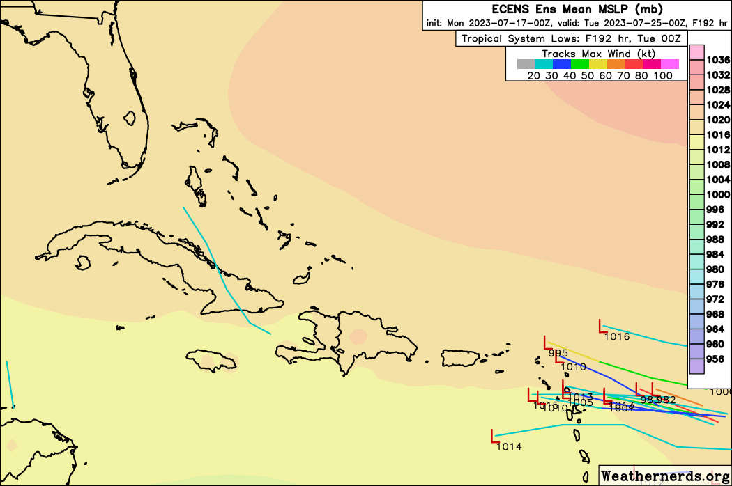
00z ECMWF operational was quiet, but some activity with the ECENS…
0 likes
Hurricane Eye Experience: David 79, Irene 99, Frances 04, Jeanne 04, Wilma 05… Hurricane Brush Experience: Andrew 92, Erin 95, Floyd 99, Matthew 16, Irma 17, Ian 22, Nicole 22…

Re: 2023 Global Model Runs Discussion (Out thru day 16)
ICON has a wave coming off the African coast in about 48 hrs and keeps it intact thru its trek into the MDR.
Its the same one GFS is developing into a TC.
Its the same one GFS is developing into a TC.
1 likes

Re: 2023 Global Model Runs Discussion (Out thru day 16)
GCANE wrote:ICON has a wave coming off the African coast in about 48 hrs and keeps it intact thru its trek into the MDR.
Its the same one GFS is developing into a TC.
I was just about to post the Icon was hinting at something. The ECMWF is showing the same wave track all the way to Florida/Cuba(with no development, but still trackable). Edit to add: Euro ensembles are getting interesting also!
Definitely getting more interesting. While I think the GFS's last run was bonkers, this is certainly becoming something to watch.
4 likes
-
Blown Away
- S2K Supporter
- Posts: 10253
- Joined: Wed May 26, 2004 6:17 am
Re: 2023 Global Model Runs Discussion (Out thru day 16)
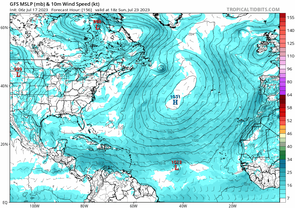
06z GFS... Continues developing into MH but misses NE Caribbean, Bahamas, and CONUS on this run.
0 likes
Hurricane Eye Experience: David 79, Irene 99, Frances 04, Jeanne 04, Wilma 05… Hurricane Brush Experience: Andrew 92, Erin 95, Floyd 99, Matthew 16, Irma 17, Ian 22, Nicole 22…
-
Blown Away
- S2K Supporter
- Posts: 10253
- Joined: Wed May 26, 2004 6:17 am
Re: 2023 Global Model Runs Discussion (Out thru day 16)
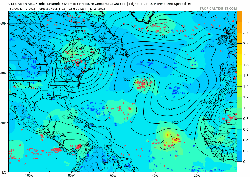
06z GEFS... (2) Camps, recurve and into Bahamas... If low consolidates, location where this happens and forward speed the biggest factors...
0 likes
Hurricane Eye Experience: David 79, Irene 99, Frances 04, Jeanne 04, Wilma 05… Hurricane Brush Experience: Andrew 92, Erin 95, Floyd 99, Matthew 16, Irma 17, Ian 22, Nicole 22…
-
WeatherBoy2000
- Category 1
- Posts: 462
- Joined: Mon Apr 10, 2023 9:29 am
Re: 2023 Global Model Runs Discussion (Out thru day 16)
https://twitter.com/AndyHazelton/status/1680899393690411013
https://twitter.com/OSUWXGUY/status/1680901907546554368
The chances of anything developing at all are still marginal due to the typical early season issues of dry air and fast trades. The GFS is likely overdoing it as it often does beyond the 5-7 day mark.
https://twitter.com/OSUWXGUY/status/1680901907546554368
The chances of anything developing at all are still marginal due to the typical early season issues of dry air and fast trades. The GFS is likely overdoing it as it often does beyond the 5-7 day mark.
0 likes
-
wxman57

- Moderator-Pro Met

- Posts: 23175
- Age: 68
- Joined: Sat Jun 21, 2003 8:06 pm
- Location: Houston, TX (southwest)
Re: 2023 Global Model Runs Discussion (Out thru day 16)
Nothing to see here, folks. GFS is developing another spurious hurricane in the long range. Such development is quite unlikely. Enjoy the quiet over the next couple of weeks.
7 likes
Who is online
Users browsing this forum: No registered users and 330 guests