2023 Global Model Runs Discussion (Out thru day 16)

This is the general tropical discussion area. Anyone can take their shot at predicting a storms path.

Moderator: S2k Moderators

Forum rules

The posts in this forum are NOT official forecasts and should not be used as such. They are just the opinion of the poster and may or may not be backed by sound meteorological data. They are NOT endorsed by any professional institution or STORM2K. For official information, please refer to products from the National Hurricane Center and National Weather Service.

Help Support Storm2K
Message
Author
User avatar
Cpv17
Category 5
Category 5
Posts: 4979
Joined: Wed Dec 07, 2016 2:24 pm
Location: Wharton/El Campo, TX

Re: 2023 Global Model Runs Discussion (Out thru day 16)

#461 Postby Cpv17 » Mon Jul 17, 2023 7:16 pm

ElectricStorm wrote:18z run is much more realistic, perhaps a TD/weak TS forming before falling apart due to shear near the islands. Still about a month too early to see any strong CV storms.

IMO chances of development are probably around 20-30% right now.


All it needs to do is make it make it to the NW Caribbean or SW Atlantic without completely dying off and it could go boom.
1 likes   

BobHarlem
Category 5
Category 5
Posts: 2108
Joined: Thu Oct 20, 2005 6:11 pm

Re: 2023 Global Model Runs Discussion (Out thru day 16)

#462 Postby BobHarlem » Mon Jul 17, 2023 7:42 pm

18z gfs ensembles
Image
2 likes   

User avatar
Category5Kaiju
Category 5
Category 5
Posts: 4097
Joined: Thu Dec 24, 2020 12:45 pm
Location: Seattle

Re: 2023 Global Model Runs Discussion (Out thru day 16)

#463 Postby Category5Kaiju » Mon Jul 17, 2023 7:46 pm

The way I see things, I'd like to monitor trends and ensembles rather than individual runs. Especially this early, the GFS may (or may not be) correct in the idea of an MDR storm forming and then threatening Florida, the Bahamas, or wherever. But exact intensity and track are still up in the air. Literally 3 runs ago, the GFS had the idea of Dorian 2.0. Then now it's nothing. These fluctuations and run-to-run inconsistencies will inevitably occur, but it'll be key to see what is favored as we progress through this week. Will it be a nothingburger, or will it be a somethingburger? :D
8 likes   
Unless explicitly stated, all info in my posts is based on my own opinions and observations. Tropical storms and hurricanes can be extremely dangerous. Do not think you can beat Mother Nature. Refer to an accredited weather research agency or meteorologist if you need to make serious decisions regarding an approaching storm.

User avatar
Blown Away
S2K Supporter
S2K Supporter
Posts: 10145
Joined: Wed May 26, 2004 6:17 am

Re: 2023 Global Model Runs Discussion (Out thru day 16)

#464 Postby Blown Away » Mon Jul 17, 2023 7:56 pm

BobHarlem wrote:18z gfs ensembles
https://i.imgur.com/I2xvXmm.png

18z GEFS appear at bit more active than previous runs…
0 likes   
Hurricane Eye Experience: David 79, Irene 99, Frances 04, Jeanne 04, Wilma 05... EYE COMING MY WAY IN 2024…
Hurricane Brush Experience: Andrew 92, Erin 95, Floyd 99, Matthew 16, Irma 17, Ian 22, Nicole 22…

User avatar
Cpv17
Category 5
Category 5
Posts: 4979
Joined: Wed Dec 07, 2016 2:24 pm
Location: Wharton/El Campo, TX

Re: 2023 Global Model Runs Discussion (Out thru day 16)

#465 Postby Cpv17 » Mon Jul 17, 2023 8:30 pm

Category5Kaiju wrote:The way I see things, I'd like to monitor trends and ensembles rather than individual runs. Especially this early, the GFS may (or may not be) correct in the idea of an MDR storm forming and then threatening Florida, the Bahamas, or wherever. But exact intensity and track are still up in the air. Literally 3 runs ago, the GFS had the idea of Dorian 2.0. Then now it's nothing. These fluctuations and run-to-run inconsistencies will inevitably occur, but it'll be key to see what is favored as we progress through this week. Will it be a nothingburger, or will it be a somethingburger? :D


This ^

I couldn’t really care less what operationals say at this range. They will flip flop all over the place. Pay attention to the ensembles.
5 likes   

User avatar
Teban54
Category 5
Category 5
Posts: 3204
Joined: Sat May 19, 2018 1:19 pm

Re: 2023 Global Model Runs Discussion (Out thru day 16)

#466 Postby Teban54 » Mon Jul 17, 2023 9:32 pm

Category5Kaiju wrote:The way I see things, I'd like to monitor trends and ensembles rather than individual runs. Especially this early, the GFS may (or may not be) correct in the idea of an MDR storm forming and then threatening Florida, the Bahamas, or wherever. But exact intensity and track are still up in the air. Literally 3 runs ago, the GFS had the idea of Dorian 2.0. Then now it's nothing. These fluctuations and run-to-run inconsistencies will inevitably occur, but it'll be key to see what is favored as we progress through this week. Will it be a nothingburger, or will it be a somethingburger? :D

Yeah, I don't think anyone is taking the GFS runs of 960mb landfalling majors at verbatim, but the potential for at least a TD/TS in the MDR is very real (even if not too high) and bears watching.
0 likes   

User avatar
LemieT
Tropical Depression
Tropical Depression
Posts: 78
Age: 40
Joined: Sun Jun 13, 2021 5:31 pm
Location: Barbados

Re: 2023 Global Model Runs Discussion (Out thru day 16)

#467 Postby LemieT » Mon Jul 17, 2023 10:07 pm

This model prognosticating is fun and exciting. My overall take over the years has been if the majority of models have a trackable feature (even if it's "just a tropical wave"), something will be there. What that something will be is yet to be determined and the tropics are always FULL of surprises. I'm guessing it won't be until we get to the later part of the week that the picture becomes much clearer.
2 likes   

User avatar
Category5Kaiju
Category 5
Category 5
Posts: 4097
Joined: Thu Dec 24, 2020 12:45 pm
Location: Seattle

Re: 2023 Global Model Runs Discussion (Out thru day 16)

#468 Postby Category5Kaiju » Mon Jul 17, 2023 11:34 pm

Oh boy, this 00z GFS run is going to be a wild one, I can tell :lol:

What-would-be-Emily-assuming-no-surprise-storms-happen-before builds a solid core in the MDR before recurving east of the Lesser Antilles. A stark contrast compared to the 18z run.
0 likes   
Unless explicitly stated, all info in my posts is based on my own opinions and observations. Tropical storms and hurricanes can be extremely dangerous. Do not think you can beat Mother Nature. Refer to an accredited weather research agency or meteorologist if you need to make serious decisions regarding an approaching storm.

hurricane2025
Tropical Storm
Tropical Storm
Posts: 208
Joined: Thu Apr 08, 2021 10:36 am

Re: 2023 Global Model Runs Discussion (Out thru day 16)

#469 Postby hurricane2025 » Tue Jul 18, 2023 12:03 am

Will be fish this run ridge weakening
0 likes   

User avatar
Blown Away
S2K Supporter
S2K Supporter
Posts: 10145
Joined: Wed May 26, 2004 6:17 am

Re: 2023 Global Model Runs Discussion (Out thru day 16)

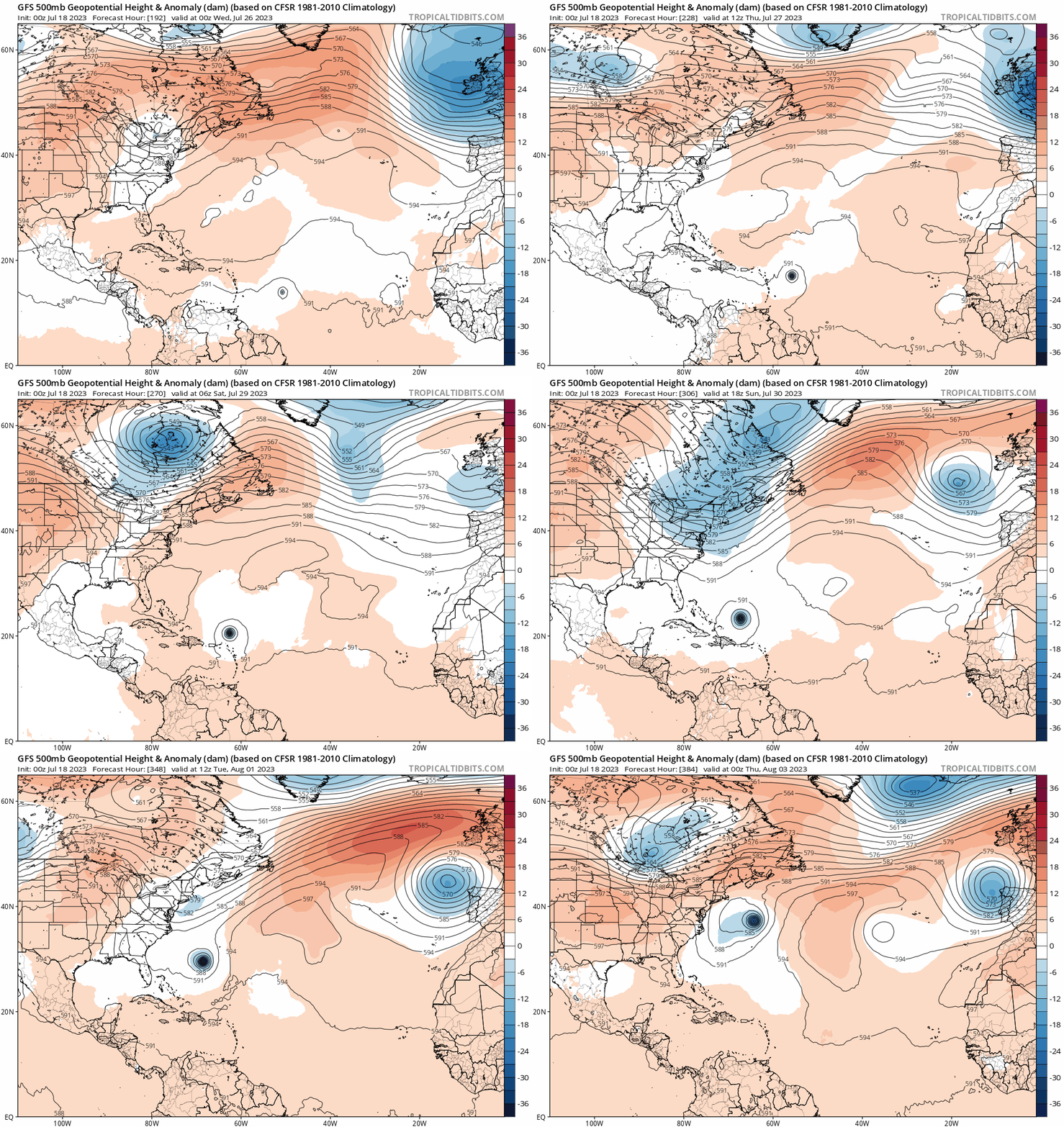
#470 Postby Blown Away » Tue Jul 18, 2023 12:22 am

Image
00z GFS is back to MH… Recurves pretty sharp, would think it doesn’t take much to miss that trough… Still way to far out to draw any reasonable conclusions…
1 likes   
Hurricane Eye Experience: David 79, Irene 99, Frances 04, Jeanne 04, Wilma 05... EYE COMING MY WAY IN 2024…
Hurricane Brush Experience: Andrew 92, Erin 95, Floyd 99, Matthew 16, Irma 17, Ian 22, Nicole 22…

emeraldislenc
Category 2
Category 2
Posts: 559
Joined: Fri Aug 24, 2012 4:49 pm
Location: Emerald Isle NC

Re: 2023 Global Model Runs Discussion (Out thru day 16)

#471 Postby emeraldislenc » Tue Jul 18, 2023 12:35 am

Way to early to make conclusions!
0 likes   

LarryWx
S2K Supporter
S2K Supporter
Posts: 6305
Joined: Sun Sep 07, 2003 2:04 pm
Location: GA

Re: 2023 Global Model Runs Discussion (Out thru day 16)

#472 Postby LarryWx » Tue Jul 18, 2023 3:32 am

0Z EPS: much weaker with this vs the prior two runs with only one H (a MH). At 0Z yesterday, it was way more active and with 7 H (5-6 MH).
0 likes   
Personal Forecast Disclaimer:
The posts in this forum are NOT official forecasts and should not be used as such. They are just the opinion of the poster and may or may not be backed by sound meteorological data. They are NOT endorsed by any professional institution or storm2k.org. For official information, please refer to the NHC and NWS products.

BobHarlem
Category 5
Category 5
Posts: 2108
Joined: Thu Oct 20, 2005 6:11 pm

Re: 2023 Global Model Runs Discussion (Out thru day 16)

#473 Postby BobHarlem » Tue Jul 18, 2023 5:46 am

6z GFS it stays in the Caribbean, quite a bit different from the 0z which was out to sea. Euro and CMC operational have nothing really other than a barely identifiable wave eventually wandering into Central America. There are a few ensembles on both the Euro and GFS side that develop it, but less members than yesterday.

6z gfs has it west of Cuba though after its Caribbean sea run.
Image
1 likes   

User avatar
wxman57
Moderator-Pro Met
Moderator-Pro Met
Posts: 22978
Age: 67
Joined: Sat Jun 21, 2003 8:06 pm
Location: Houston, TX (southwest)

Re: 2023 Global Model Runs Discussion (Out thru day 16)

#474 Postby wxman57 » Tue Jul 18, 2023 8:06 am

6Z GFS is much more realistic in keeping the wave south through the Caribbean as a wave, not a hurricane. Close to the Euro.
6 likes   

User avatar
Teban54
Category 5
Category 5
Posts: 3204
Joined: Sat May 19, 2018 1:19 pm

Re: 2023 Global Model Runs Discussion (Out thru day 16)

#475 Postby Teban54 » Tue Jul 18, 2023 10:19 am

Teban54 wrote:
South Texas Storms wrote:
wxman57 wrote:
When the GFS is the outlier, don't believe it. I think the wave near Africa will most likely track through the Caribbean without development.


Agreed. And the fact that the operational Canadian model and all of it's ensemble members don't develop this wave is quite telling. The Canadian is typically one of the more bullish models in showing TC genesis.

Not necessarily: A few users have commented on how CMC went from "Constantly Making Cyclones" to "Can't Make Cyclones" at various times this year.

Case in point...
 https://twitter.com/DerekOrtt/status/1681158886802493445


Something is broken with the Canadian model. It for some reason is unable to intensify any TC these days. It is the only model not doing anything with Don, not to mention anything in the tropical Atlantic
0 likes   

LarryWx
S2K Supporter
S2K Supporter
Posts: 6305
Joined: Sun Sep 07, 2003 2:04 pm
Location: GA

Re: 2023 Global Model Runs Discussion (Out thru day 16)

#476 Postby LarryWx » Tue Jul 18, 2023 10:40 am

So, CMC is broken the other way now. Which is worse?
2 likes   
Personal Forecast Disclaimer:
The posts in this forum are NOT official forecasts and should not be used as such. They are just the opinion of the poster and may or may not be backed by sound meteorological data. They are NOT endorsed by any professional institution or storm2k.org. For official information, please refer to the NHC and NWS products.

LarryWx
S2K Supporter
S2K Supporter
Posts: 6305
Joined: Sun Sep 07, 2003 2:04 pm
Location: GA

Re: 2023 Global Model Runs Discussion (Out thru day 16)

#477 Postby LarryWx » Tue Jul 18, 2023 10:55 am

12Z ICON has the typical quiet late July in the MDR throughout the run.
0 likes   
Personal Forecast Disclaimer:
The posts in this forum are NOT official forecasts and should not be used as such. They are just the opinion of the poster and may or may not be backed by sound meteorological data. They are NOT endorsed by any professional institution or storm2k.org. For official information, please refer to the NHC and NWS products.

User avatar
ScottNAtlanta
Category 5
Category 5
Posts: 2367
Joined: Sat May 25, 2013 3:11 pm
Location: Atlanta, GA

Re: 2023 Global Model Runs Discussion (Out thru day 16)

#478 Postby ScottNAtlanta » Tue Jul 18, 2023 11:01 am

Blown Away wrote:[url]https://i.postimg.cc/2jxrv8cv/gfs-z500a-atl-fh192-384.gif [/url]
00z GFS is back to MH… Recurves pretty sharp, would think it doesn’t take much to miss that trough… Still way to far out to draw any reasonable conclusions…


That's kind of concerning how high pressure strengthens over the top. It being far out not withstanding, if there is a storm there it isn't going to barrel into a high. If that is the pattern it would probably stall and loop back west. That isn't going to be what happens, but remember the GFS has always had a recurve bias when it correctly identifies genesis early. It almost always corrects west as time goes by. Stay tuned
2 likes   
The posts in this forum are NOT official forecast and should not be used as such. They are just the opinion of the poster and may or may not be backed by sound meteorological data. They are NOT endorsed by any professional institution or storm2k.org. For official information, please refer to the NHC and NWS products.

LarryWx
S2K Supporter
S2K Supporter
Posts: 6305
Joined: Sun Sep 07, 2003 2:04 pm
Location: GA

Re: 2023 Global Model Runs Discussion (Out thru day 16)

#479 Postby LarryWx » Tue Jul 18, 2023 11:06 am

Through 168, the 12Z GFS is about as weak as any recent run with the MDR wave being watched.
0 likes   
Personal Forecast Disclaimer:
The posts in this forum are NOT official forecasts and should not be used as such. They are just the opinion of the poster and may or may not be backed by sound meteorological data. They are NOT endorsed by any professional institution or storm2k.org. For official information, please refer to the NHC and NWS products.

User avatar
Spacecoast
Category 2
Category 2
Posts: 758
Joined: Thu Aug 31, 2017 2:03 pm

Re: 2023 Global Model Runs Discussion (Out thru day 16)

#480 Postby Spacecoast » Tue Jul 18, 2023 11:20 am

LarryWx wrote:So, CMC is broken the other way now. Which is worse?


:lol: ... Quite the philosophical question.
2 likes   


Return to “Talkin' Tropics”

Who is online

Users browsing this forum: Hurrilurker, Sciencerocks and 56 guests