AL, 95, 2023071918, , BEST, 0, 94N, 404W, 15, 1015, DB, 0, , 0, 0, 0, 0, 0, 0, 0, 0, 0, L, 0, , 0, 0, GENESIS014, , 0, , 0, 0, 0, 0, genesis-num, 014,
AL, 95, 2023072000, , BEST, 0, 98N, 400W, 15, 1015, DB, 0, , 0, 0, 0, 0, 0, 0, 70, 0, 0, L, 0, , 0, 0, GENESIS014, , 0, , 0, 0, 0, 0, genesis-num, 014,
AL, 95, 2023072006, , BEST, 0, 103N, 394W, 15, 1015, DB, 0, , 0, 0, 0, 0, 0, 0, 70, 0, 0, L, 0, , 0, 0, GENESIS014, , 0, , 0, 0, 0, 0, genesis-num, 014,
AL, 95, 2023072012, , BEST, 0, 107N, 390W, 20, 1015, DB, 0, , 0, 0, 0, 0, 0, 0, 60, 0, 0, L, 0, , 0, 0, GENESIS014, , 0, , 0, 0, 0, 0, genesis-num, 014,
AL, 95, 2023072018, , BEST, 0, 110N, 388W, 25, 1015, LO, 0, , 0, 0, 0, 0, 1016, 100, 40, 0, 0, L, 0, , 0, 0, GENESIS014, , 0, , 0, 0, 0, 0, genesis-num, 014,
AL, 95, 2023072100, , BEST, 0, 113N, 387W, 25, 1014, LO, 34, NEQ, 0, 0, 0, 0, 1016, 100, 40, 0, 0, L, 0, , 0, 0, INVEST, S, 0, , 0, 0, 0, 0, genesis-num, 014, SPAWNINVEST, al752023 to al952023,
https://ftp.nhc.noaa.gov/atcf/btk/bal952023.dat
https://ftp.nhc.noaa.gov/atcf/btk/
ATL: INVEST 95L - Discussion
Moderator: S2k Moderators
-
tolakram
- Admin

- Posts: 20186
- Age: 62
- Joined: Sun Aug 27, 2006 8:23 pm
- Location: Florence, KY (name is Mark)
ATL: INVEST 95L - Discussion
0 likes
M a r k
- - - - -
Join us in chat: Storm2K Chatroom Invite. Android and IOS apps also available.
The posts in this forum are NOT official forecasts and should not be used as such. Posts are NOT endorsed by any professional institution or STORM2K.org. For official information and forecasts, please refer to NHC and NWS products.
-
Hurricane2022

- Category 5

- Posts: 2092
- Joined: Tue Aug 23, 2022 11:38 pm
- Location: Araçatuba, Brazil
Re: ATL: INVEST 95L
Waiting to see the HWRF showing a (major) hurricane at day 5! 
3 likes
Sorry for the bad English sometimes...!
For reliable and detailed information for any meteorological phenomenon, please consult the National Hurricane Center, Joint Typhoon Warning Center , or your local Meteo Center.
--------
ECCE OMNIA NOVA FACIAM (Ap 21,5).
For reliable and detailed information for any meteorological phenomenon, please consult the National Hurricane Center, Joint Typhoon Warning Center , or your local Meteo Center.
--------
ECCE OMNIA NOVA FACIAM (Ap 21,5).
-
tolakram
- Admin
- Posts: 20186
- Age: 62
- Joined: Sun Aug 27, 2006 8:23 pm
- Location: Florence, KY (name is Mark)
Re: ATL: INVEST 95L - Discussion
1. Central Tropical Atlantic:
An area of low pressure has formed within the Intertropical
Convergence Zone, located several hundred miles west-southwest of
the Cabo Verde Islands. This system is also interacting with a
tropical wave located farther east, and their combination is
producing an elongated area of showers and thunderstorms over the
eastern and central tropical Atlantic. While environmental
conditions appear only somewhat favorable due to the proximity of
dry air to the north, some slow development of this system is
possible through early next week, as it begins to move westward
across the central tropical Atlantic.
* Formation chance through 48 hours...low...10 percent.
* Formation chance through 7 days...low...30 percent.
Forecaster Papin
0 likes
M a r k
- - - - -
Join us in chat: Storm2K Chatroom Invite. Android and IOS apps also available.
The posts in this forum are NOT official forecasts and should not be used as such. Posts are NOT endorsed by any professional institution or STORM2K.org. For official information and forecasts, please refer to NHC and NWS products.
- - - - -
Join us in chat: Storm2K Chatroom Invite. Android and IOS apps also available.
The posts in this forum are NOT official forecasts and should not be used as such. Posts are NOT endorsed by any professional institution or STORM2K.org. For official information and forecasts, please refer to NHC and NWS products.
-
Sciencerocks
- Category 5
- Posts: 10193
- Age: 40
- Joined: Thu Jul 06, 2017 1:51 am

-
jlauderdal
- S2K Supporter

- Posts: 7240
- Joined: Wed May 19, 2004 5:46 am
- Location: NE Fort Lauderdale
- Contact:
Re: RE: Re: ATL: INVEST 95L - Discussion
Good enough for a lemon!tolakram wrote:1. Central Tropical Atlantic:
An area of low pressure has formed within the Intertropical
Convergence Zone, located several hundred miles west-southwest of
the Cabo Verde Islands. This system is also interacting with a
tropical wave located farther east, and their combination is
producing an elongated area of showers and thunderstorms over the
eastern and central tropical Atlantic. While environmental
conditions appear only somewhat favorable due to the proximity of
dry air to the north, some slow development of this system is
possible through early next week, as it begins to move westward
across the central tropical Atlantic.
* Formation chance through 48 hours...low...10 percent.
* Formation chance through 7 days...low...30 percent.
Forecaster Papin
0 likes
-
Blown Away

- S2K Supporter
- Posts: 10253
- Joined: Wed May 26, 2004 6:17 am
Re: ATL: INVEST 95L - Discussion
NHC moved the 8pm X about 8 degrees W from the 2pm position… Wow big jump.
0 likes
Hurricane Eye Experience: David 79, Irene 99, Frances 04, Jeanne 04, Wilma 05… Hurricane Brush Experience: Andrew 92, Erin 95, Floyd 99, Matthew 16, Irma 17, Ian 22, Nicole 22…
-
cycloneye

- Admin
- Posts: 149696
- Age: 69
- Joined: Thu Oct 10, 2002 10:54 am
- Location: San Juan, Puerto Rico
Re: ATL: INVEST 95L - Discussion
Blown Away wrote:NHC moved the 8pm X about 8 degrees W from the 2pm position… Wow big jump.
That was my catch this morning when I posted the animation of the interesting area near 11N-38W.
8 likes
Visit the Caribbean-Central America Weather Thread where you can find at first post web cams,radars
and observations from Caribbean basin members Click Here
and observations from Caribbean basin members Click Here


Re: ATL: INVEST 95L - Discussion
This may wind up being a relatively tiny system, will be interesting to see how this and the models progress on it because of that.
3 likes
-
Category5Kaiju

- Category 5
- Posts: 4345
- Joined: Thu Dec 24, 2020 12:45 pm
- Location: Seattle during the summer, Phoenix during the winter
Re: ATL: INVEST 95L - Discussion
BobHarlem wrote:This may wind up being a relatively tiny system, will be interesting to see how this and the models progress on it because of that.
From Hurricane Dorian to EPAC'S Hurricane Darby (2022), we still have work to do regarding accurately modeling small systems. They typically fall apart when under the wrong conditions, but sometimes they don't and do the complete opposite.
1 likes
Unless explicitly stated, all information in my posts is based on my own opinions and observations. Tropical storms and hurricanes can be extremely dangerous. Refer to an accredited weather research agency or meteorologist if you need to make serious decisions regarding an approaching storm.
-
ElectricStorm

- Category 5
- Posts: 5153
- Age: 25
- Joined: Tue Aug 13, 2019 11:23 pm
- Location: Norman, OK
Re: ATL: INVEST 95L - Discussion
Well this could be interesting. Would be crazy to have 3 MDR storms east of the islands before August.
2 likes
B.S Meteorology, University of Oklahoma '25
Please refer to the NHC, NWS, or SPC for official information.
Please refer to the NHC, NWS, or SPC for official information.
Re: ATL: INVEST 95L - Discussion

Structure is very good. Just needs convection firing up to bring up the wind.
4 likes
-
cycloneye
- Admin
- Posts: 149696
- Age: 69
- Joined: Thu Oct 10, 2002 10:54 am
- Location: San Juan, Puerto Rico
Re: ATL: INVEST 95L - Discussion
Tropical Weather Outlook
NWS National Hurricane Center Miami FL
200 AM EDT Fri Jul 21 2023
For the North Atlantic...Caribbean Sea and the Gulf of Mexico:
Active Systems:
The National Hurricane Center is issuing advisories on Tropical
Storm Don, located over the central Atlantic.
Central Tropical Atlantic:
An area of low pressure, located several hundred miles
west-southwest of the Cabo Verde Islands, is interacting with a
tropical wave to its east and producing an elongated area of
showers and thunderstorms over the eastern and central tropical
Atlantic. While environmental conditions appear marginal due to
dry air to the north, some slow development of this system is
possible through early next week, as it moves westward across the
central tropical Atlantic.
* Formation chance through 48 hours...low...10 percent.
* Formation chance through 7 days...low...30 percent.
$$
Forecaster Bucci
1 likes
Visit the Caribbean-Central America Weather Thread where you can find at first post web cams,radars
and observations from Caribbean basin members Click Here
and observations from Caribbean basin members Click Here

Re: ATL: INVEST 95L - Discussion
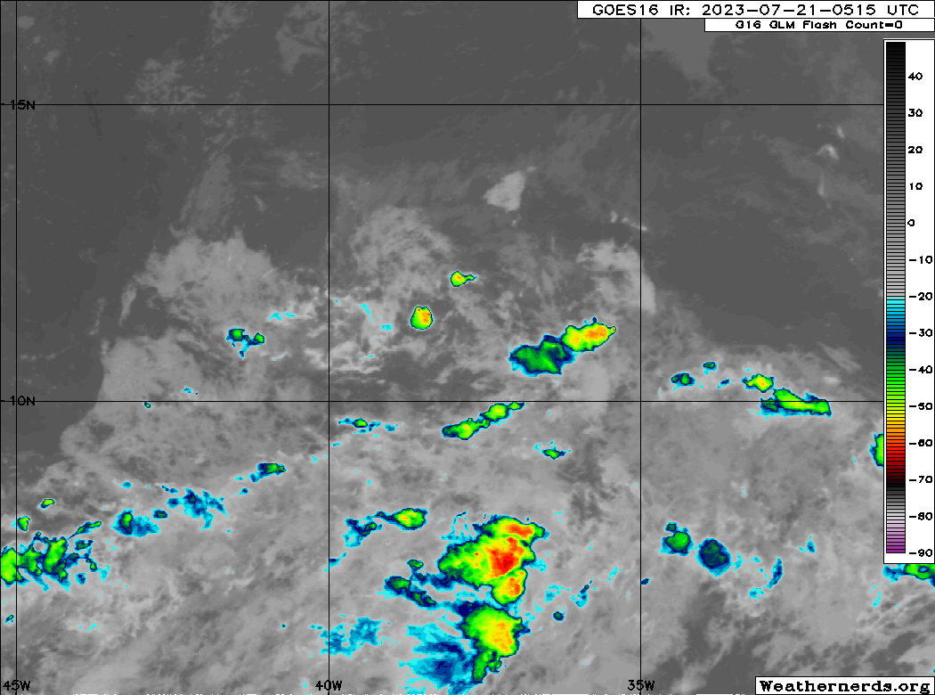
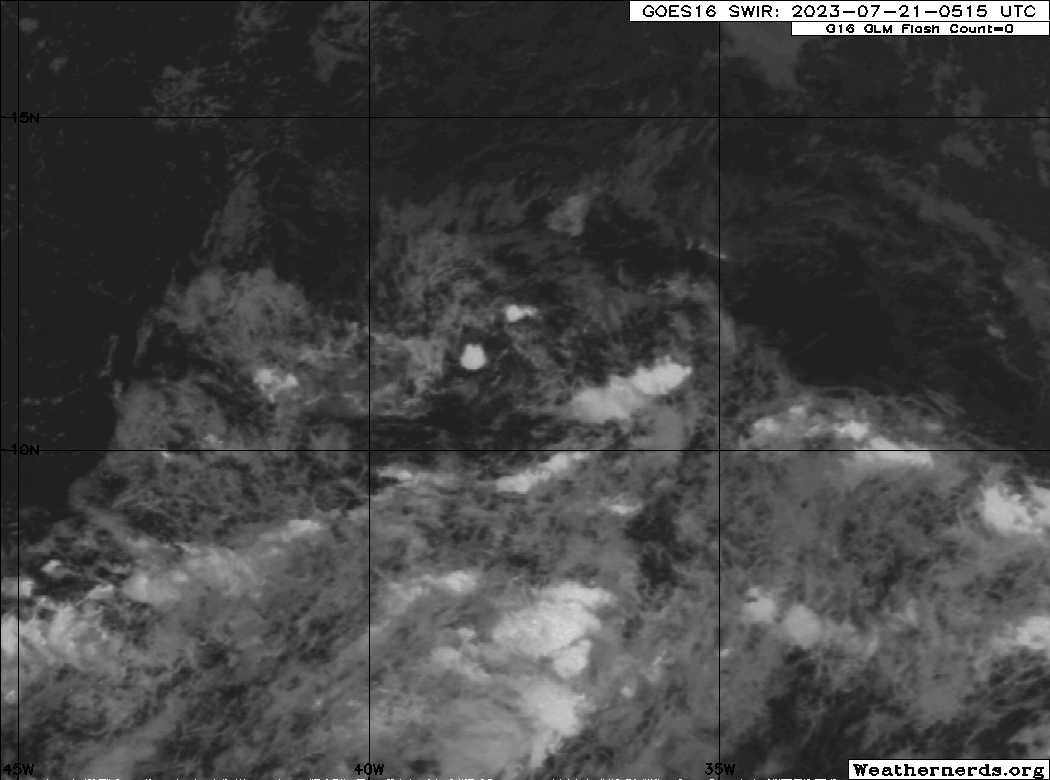
Still very dry but there's another nice tower popping up.

2 likes
TC naming lists: retirements and intensity
Most aggressive Advisory #1's in North Atlantic (cr. kevin for starting the list)
Most aggressive Advisory #1's in North Atlantic (cr. kevin for starting the list)

Re: ATL: INVEST 95L - Discussion
Teban54 wrote:Still very dry but there's another nice tower popping up.
https://i.postimg.cc/Y9XJ3rPm/goes16-ir-95-L-202307210215.gif
The convection has continued to expand and intensify. Could just be the Dmax effect and will likely wane as the morning progresses. As usual, the Shortwave Infrared (SWIR) version shows the circulation aspect very well, as it normally does at night.
0 likes
-
jlauderdal
- S2K Supporter
- Posts: 7240
- Joined: Wed May 19, 2004 5:46 am
- Location: NE Fort Lauderdale
- Contact:
Re: ATL: INVEST 95L - Discussion
cycloneye wrote:Tropical Weather Outlook
NWS National Hurricane Center Miami FL
200 AM EDT Fri Jul 21 2023
For the North Atlantic...Caribbean Sea and the Gulf of Mexico:
Active Systems:
The National Hurricane Center is issuing advisories on Tropical
Storm Don, located over the central Atlantic.
Central Tropical Atlantic:
An area of low pressure, located several hundred miles
west-southwest of the Cabo Verde Islands, is interacting with a
tropical wave to its east and producing an elongated area of
showers and thunderstorms over the eastern and central tropical
Atlantic. While environmental conditions appear marginal due to
dry air to the north, some slow development of this system is
possible through early next week, as it moves westward across the
central tropical Atlantic.
* Formation chance through 48 hours...low...10 percent.
* Formation chance through 7 days...low...30 percent.
$$
Forecaster Bucci
Still a lemon but a promotion to the sweeter tasting mandarin seems probable in its future.
2 likes
Re: ATL: INVEST 95L - Discussion
tolakram wrote:AL, 95, 2023071918, , BEST, 0, 94N, 404W, 15, 1015, DB, 0, , 0, 0, 0, 0, 0, 0, 0, 0, 0, L, 0, , 0, 0, GENESIS014, , 0, , 0, 0, 0, 0, genesis-num, 014,
AL, 95, 2023072000, , BEST, 0, 98N, 400W, 15, 1015, DB, 0, , 0, 0, 0, 0, 0, 0, 70, 0, 0, L, 0, , 0, 0, GENESIS014, , 0, , 0, 0, 0, 0, genesis-num, 014,
AL, 95, 2023072006, , BEST, 0, 103N, 394W, 15, 1015, DB, 0, , 0, 0, 0, 0, 0, 0, 70, 0, 0, L, 0, , 0, 0, GENESIS014, , 0, , 0, 0, 0, 0, genesis-num, 014,
AL, 95, 2023072012, , BEST, 0, 107N, 390W, 20, 1015, DB, 0, , 0, 0, 0, 0, 0, 0, 60, 0, 0, L, 0, , 0, 0, GENESIS014, , 0, , 0, 0, 0, 0, genesis-num, 014,
AL, 95, 2023072018, , BEST, 0, 110N, 388W, 25, 1015, LO, 0, , 0, 0, 0, 0, 1016, 100, 40, 0, 0, L, 0, , 0, 0, GENESIS014, , 0, , 0, 0, 0, 0, genesis-num, 014,
AL, 95, 2023072100, , BEST, 0, 113N, 387W, 25, 1014, LO, 34, NEQ, 0, 0, 0, 0, 1016, 100, 40, 0, 0, L, 0, , 0, 0, INVEST, S, 0, , 0, 0, 0, 0, genesis-num, 014, SPAWNINVEST, al752023 to al952023,
https://ftp.nhc.noaa.gov/atcf/btk/bal952023.dat
https://ftp.nhc.noaa.gov/atcf/btk/
For some odd reason, the link you posted in the last reply in the Low Pressure / Tropical Wave WSW of Cabo Verde (is Invest 95L) topic, that points to this topic, logs me out of S2K whenever I click it.
1 likes
-
MHC Tracking
- Tropical Storm

- Posts: 203
- Joined: Mon Mar 15, 2021 10:05 am
Re: ATL: INVEST 95L - Discussion
Already starting to see the first evidence of what looks like banding, with the earlier ASCAT pass, it only needs persistent deep convection and it's pretty much a TC. Will be interesting to see whether models continue to play catchup like with other miniature systems. Very healthy so far

6 likes
-
Ivanhater

- Storm2k Moderator

- Posts: 11222
- Age: 39
- Joined: Fri Jul 01, 2005 8:25 am
- Location: Pensacola
Re: ATL: INVEST 95L - Discussion
We have seen time and time again Global models struggle with small systems. Quite evident uptick in development chances the last 24 hours. I suspect an incremental increase in development percentage each outlook with possible code red by tomorrow.
6 likes
Michael
Re: ATL: INVEST 95L - Discussion
very low windshear on top off it at the time been, defo wouldnt be surprised if they increased the odds on the next update
0 likes
Who is online
Users browsing this forum: No registered users and 74 guests