2023 Global Model Runs Discussion (Out thru day 16)
Moderator: S2k Moderators
Forum rules

The posts in this forum are NOT official forecasts and should not be used as such. They are just the opinion of the poster and may or may not be backed by sound meteorological data. They are NOT endorsed by any professional institution or STORM2K. For official information, please refer to products from the National Hurricane Center and National Weather Service.
-
Category5Kaiju

- Category 5

- Posts: 4334
- Joined: Thu Dec 24, 2020 12:45 pm
- Location: Seattle and Phoenix
Re: 2023 Global Model Runs Discussion (Out thru day 16)
Looks like the 12z GFS has this new end-ofJuly system as a classic Cape Verde system where it becomes a depression near the Cape Verde Islands and treks westward
2 likes
Unless explicitly stated, all info in my posts is based on my own opinions and observations. Tropical storms and hurricanes can be extremely dangerous. Refer to an accredited weather research agency or meteorologist if you need to make serious decisions regarding an approaching storm.

Re: 2023 Global Model Runs Discussion (Out thru day 16)
toad strangler wrote:Blown Away wrote:Teban54 wrote:It's still July.
And the seasonal forecasts were not made using 384 hrs GFS runs.
Except for our potential GFS phantom storm there is very little in the models up to @8/8 and nothing in the MDR at that time. Just an observation.
8/20 ding ding ding!
Typically, yes.
This year, no.
If we’re to get to the numbers forecasted then we’ll need the real season to come well before that date. This isn’t your typical year.
0 likes

Re: 2023 Global Model Runs Discussion (Out thru day 16)
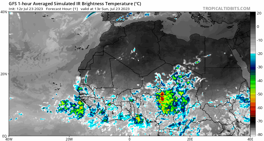
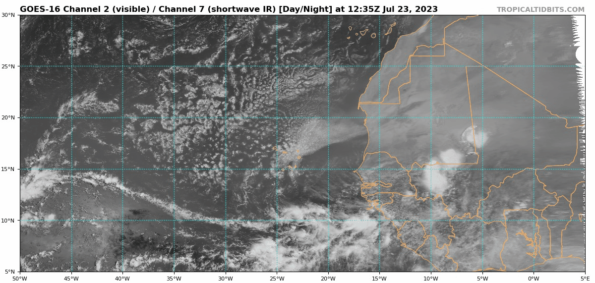
gatorcane wrote:You can see the wave the models are picking up on in this loop. Nice broad rotation/spin around 13N 8W with convection slightly sheared to the west side:
https://i.postimg.cc/0QZf9LVV/goes16-vis-swir-eatl.gif
It does look formidable plus it'll have a healthy inflow from a moist ITCZ already beginning to bow northward along the African coast in response to the deep SW flow ahead of the approaching wave. I think it could be a candidate for a relative quick spin up following "splash-down".
0 likes
Andy D
(For official information, please refer to the NHC and NWS products.)
(For official information, please refer to the NHC and NWS products.)
-
WeatherBoy2000
- Category 1

- Posts: 462
- Joined: Mon Apr 10, 2023 9:29 am
Re: 2023 Global Model Runs Discussion (Out thru day 16)
Category5Kaiju wrote:Looks like the 12z GFS has this new end-ofJuly system as a classic Cape Verde system where it becomes a depression near the Cape Verde Islands and treks westward
The GFS showed something like this happening with 95l at this stage and that didn't verify. Although nothing should be taken literally, the fact that models are beginning to develop waves along with an invest might be a sign that the Atlantic is waking up. Surely beats last year and even 2021.
2 likes
-
SFLcane

- S2K Supporter

- Posts: 10281
- Age: 48
- Joined: Sat Jun 05, 2010 1:44 pm
- Location: Lake Worth Florida
Re: 2023 Global Model Runs Discussion (Out thru day 16)
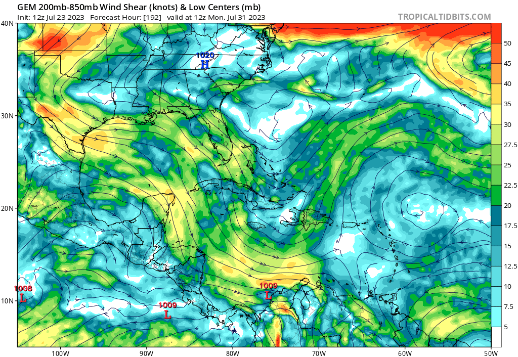
12z Gfs again with a strengthening hurricane going into the sw Atlantic. Long range forecast so we will see what happens
1 likes
-
cycloneye

- Admin

- Posts: 149508
- Age: 69
- Joined: Thu Oct 10, 2002 10:54 am
- Location: San Juan, Puerto Rico
Re: 2023 Global Model Runs Discussion (Out thru day 16)
There is the culprit as gatorcane said.

1 likes
Visit the Caribbean-Central America Weather Thread where you can find at first post web cams,radars
and observations from Caribbean basin members Click Here
and observations from Caribbean basin members Click Here
-
tolakram
- Admin
- Posts: 20186
- Age: 62
- Joined: Sun Aug 27, 2006 8:23 pm
- Location: Florence, KY (name is Mark)
Re: 2023 Global Model Runs Discussion (Out thru day 16)
The models show trends. I know it's hard not to game them, but the GFS spinning something up to a hurricane IS meaningless. The GFS and the euro both showing a vorticity in the same area, regardless of strength, is a decent signal. I doubt both of them this far out, but both the GFS and Euro show the vorticity moving over or just north of the islands at 180+ hours. If a storm is going to be of any significant intensity that's the route it's going to have to take in my opinion.
Still too far out to have any confidence.
Still too far out to have any confidence.
1 likes
M a r k
- - - - -
Join us in chat: Storm2K Chatroom Invite. Android and IOS apps also available.
The posts in this forum are NOT official forecasts and should not be used as such. Posts are NOT endorsed by any professional institution or STORM2K.org. For official information and forecasts, please refer to NHC and NWS products.
-
Spacecoast

- Category 2

- Posts: 773
- Joined: Thu Aug 31, 2017 2:03 pm

-
gatorcane

- S2K Supporter
- Posts: 23708
- Age: 48
- Joined: Sun Mar 13, 2005 3:54 pm
- Location: Boca Raton, FL
Re: 2023 Global Model Runs Discussion (Out thru day 16)
tolakram wrote:The models show trends. I know it's hard not to game them, but the GFS spinning something up to a hurricane IS meaningless. The GFS and the euro both showing a vorticity in the same area, regardless of strength, is a decent signal. I doubt both of them this far out, but both the GFS and Euro show the vorticity moving over or just north of the islands at 180+ hours. If a storm is going to be of any significant intensity that's the route it's going to have to take in my opinion.
Still too far out to have any confidence.
Agree with this. The route for development would be if it were to move near or north of the islands. One thing I notice looking at the Euro, GFS, and CMC is that they all move the TUTT near the islands off to the northeast and build in a large anticyclone over this wave just north of the islands around around 180 hours from now. The CMC still fails to develop the wave despite this favorable upper-level environment.
12Z CMC showing anticyclone flow just NE of islands which would be favorable:
1 likes
-
SFLcane
- S2K Supporter
- Posts: 10281
- Age: 48
- Joined: Sat Jun 05, 2010 1:44 pm
- Location: Lake Worth Florida
Re: 2023 Global Model Runs Discussion (Out thru day 16)
That sounds about right. One to watch
2 likes
-
toad strangler

- S2K Supporter
- Posts: 4546
- Joined: Sun Jul 28, 2013 3:09 pm
- Location: Earth
- Contact:
Re: 2023 Global Model Runs Discussion (Out thru day 16)
Cpv17 wrote:toad strangler wrote:Blown Away wrote:
Except for our potential GFS phantom storm there is very little in the models up to @8/8 and nothing in the MDR at that time. Just an observation.
8/20 ding ding ding!
Typically, yes.
This year, no.
If we’re to get to the numbers forecasted then we’ll need the real season to come well before that date. This isn’t your typical year.
Not in agreement with this sentiment. There have been big canes in strong El Niño years. It’s not a forgone conclusion that this Nino shuts down the Atlantic. Plus, it only take one. I’m not a numbers guy. I typically disregard storm total numbers. Total ACE included. Means nothing to those who might get that one.
2 likes
My Weather Station
https://www.wunderground.com/dashboard/pws/KFLPORTS603
https://www.wunderground.com/dashboard/pws/KFLPORTS603
-
USTropics
- Professional-Met

- Posts: 2739
- Joined: Sun Aug 12, 2007 3:45 am
- Location: Florida State University
Re: 2023 Global Model Runs Discussion (Out thru day 16)
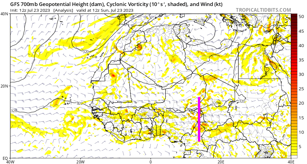
The primary wave axis for the feature the GFS has been developing is along 10-12E currently:

It's a bit easier to track by following the changes of the wind barbs at 700mb:
It shows up well on the GFS simulated satellite:
It's a bit easier to track by following the changes of the wind barbs at 700mb:
It shows up well on the GFS simulated satellite:
8 likes
Re: 2023 Global Model Runs Discussion (Out thru day 16)
toad strangler wrote:Cpv17 wrote:toad strangler wrote:
8/20 ding ding ding!
Typically, yes.
This year, no.
If we’re to get to the numbers forecasted then we’ll need the real season to come well before that date. This isn’t your typical year.
Not in agreement with this sentiment. There have been big canes in strong El Niño years. It’s not a forgone conclusion that this Nino shuts down the Atlantic. Plus, it only take one. I’m not a numbers guy. I typically disregard storm total numbers. Total ACE included. Means nothing to those who might get that one.
It’s a good bet storms will get going before the 20th this year. It’s been a wacky year. There’s been plenty of talk about this being a front-loaded season. I’m not a numbers guy either. I couldn’t care less about ACE. I’m only interested in storms that impact land. I have zero interest in fish storms.
1 likes
-
cycloneye
- Admin
- Posts: 149508
- Age: 69
- Joined: Thu Oct 10, 2002 10:54 am
- Location: San Juan, Puerto Rico
Re: 2023 Global Model Runs Discussion (Out thru day 16)
USTropics wrote:The primary wave axis for the feature the GFS has been developing is along 10-12E currently:
https://i.imgur.com/ZYoOXsT.png
It's a bit easier to track by following the changes of the wind barbs at 700mb:
https://i.postimg.cc/G2rzVTCY/gifmaker-me.gif
It shows up well on the GFS simulated satellite:
https://i.postimg.cc/5t8nsqZb/gfs-ir-nafr-fh1-115.gif
Oh boy, I and our friend gatorcane identified the wrong one.
0 likes
Visit the Caribbean-Central America Weather Thread where you can find at first post web cams,radars
and observations from Caribbean basin members Click Here
and observations from Caribbean basin members Click Here
Re: 2023 Global Model Runs Discussion (Out thru day 16)
SFLcane wrote:https://i.postimg.cc/R0j99Y8r/IMG-7329.gif
It’s common to show recurves early and they adjust back west with time.
1 likes
-
Blown Away

- S2K Supporter
- Posts: 10253
- Joined: Wed May 26, 2004 6:17 am
Re: 2023 Global Model Runs Discussion (Out thru day 16)
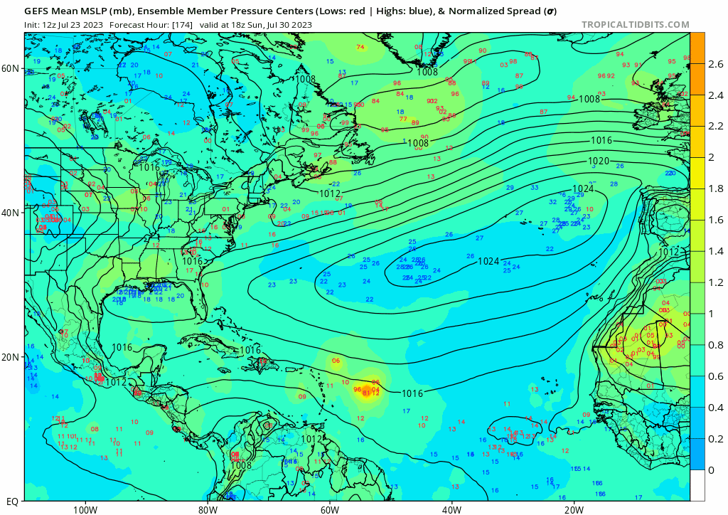
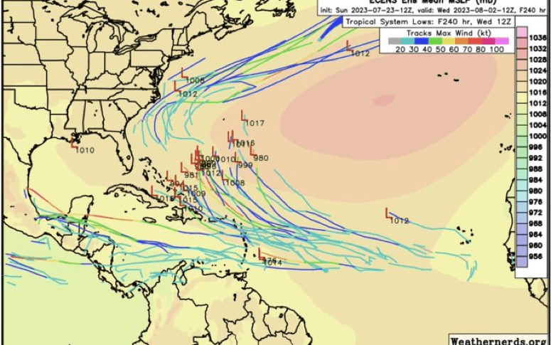
12z GEFS… After NE Caribbean, a wide range of possibilities, Central GOM to offshore CONUS…
0 likes
Hurricane Eye Experience: David 79, Irene 99, Frances 04, Jeanne 04, Wilma 05… Hurricane Brush Experience: Andrew 92, Erin 95, Floyd 99, Matthew 16, Irma 17, Ian 22, Nicole 22…
Re: 2023 Global Model Runs Discussion (Out thru day 16)
Blown Away wrote:[url]https://i.postimg.cc/Gmh433Xn/gfs-ememb-lowlocs-atl-fh174-384.gif [/url]
12z GEFS… After NE Caribbean, a wide range of possibilities, Central GOM to offshore CONUS…
There’s even some BOC action there.
1 likes
-
gatorcane
- S2K Supporter
- Posts: 23708
- Age: 48
- Joined: Sun Mar 13, 2005 3:54 pm
- Location: Boca Raton, FL
Re: 2023 Global Model Runs Discussion (Out thru day 16)
cycloneye wrote:USTropics wrote:The primary wave axis for the feature the GFS has been developing is along 10-12E currently:
https://i.imgur.com/ZYoOXsT.png
It's a bit easier to track by following the changes of the wind barbs at 700mb.
https://i.postimg.cc/G2rzVTCY/gifmaker-me.gif
It shows up well on the GFS simulated satellite:
https://i.postimg.cc/5t8nsqZb/gfs-ir-nafr-fh1-115.gif
Oh boy, I and our friend gatorcane identified the wrong one.
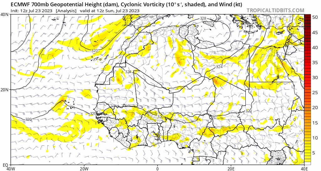
Looking at the 12Z Euro 700MB animation, it appears to be the area I had pointed out at around 13N 8W.
1 likes
-
Blown Away
- S2K Supporter
- Posts: 10253
- Joined: Wed May 26, 2004 6:17 am
Re: 2023 Global Model Runs Discussion (Out thru day 16)
gatorcane wrote:cycloneye wrote:USTropics wrote:The primary wave axis for the feature the GFS has been developing is along 10-12E currently:
https://i.imgur.com/ZYoOXsT.png
It's a bit easier to track by following the changes of the wind barbs at 700mb.
https://i.postimg.cc/G2rzVTCY/gifmaker-me.gif
It shows up well on the GFS simulated satellite:
https://i.postimg.cc/5t8nsqZb/gfs-ir-nafr-fh1-115.gif
Oh boy, I and our friend gatorcane identified the wrong one.
Looking at the 12Z Euro 700MB animation, it appears to be the area I had pointed out at around 13N 8W.
https://i.postimg.cc/W3fpwNNR/ecmwf-z700-vort-nafr-fh0-102.gif
https://i.postimg.cc/0QZf9LVV/goes16-vis-swir-eatl.gif
About 3 days until it splashes in the Atlantic and about 5 days before it shows as a low in the GFS.
0 likes
Hurricane Eye Experience: David 79, Irene 99, Frances 04, Jeanne 04, Wilma 05… Hurricane Brush Experience: Andrew 92, Erin 95, Floyd 99, Matthew 16, Irma 17, Ian 22, Nicole 22…
Who is online
Users browsing this forum: Ulf and 209 guests