I like how florida avoids both solutions.Blown Away wrote:
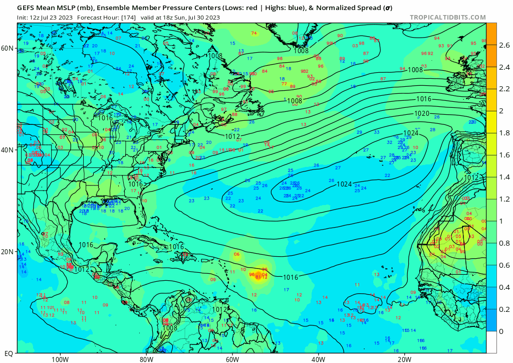
12z GEFS… After NE Caribbean, a wide range of possibilities, Central GOM to offshore CONUS…
2023 Global Model Runs Discussion (Out thru day 16)
Moderator: S2k Moderators
Forum rules

The posts in this forum are NOT official forecasts and should not be used as such. They are just the opinion of the poster and may or may not be backed by sound meteorological data. They are NOT endorsed by any professional institution or STORM2K. For official information, please refer to products from the National Hurricane Center and National Weather Service.
-
jlauderdal
- S2K Supporter

- Posts: 7240
- Joined: Wed May 19, 2004 5:46 am
- Location: NE Fort Lauderdale
- Contact:
Re: RE: Re: 2023 Global Model Runs Discussion (Out thru day 16)
1 likes


Re: 2023 Global Model Runs Discussion (Out thru day 16)
https://twitter.com/WxTca/status/1683215968711987202
https://twitter.com/WxTca/status/1683216056049971203
https://twitter.com/dmorris9661/status/1683237233996750849
https://twitter.com/WxTca/status/1683216056049971203
https://twitter.com/dmorris9661/status/1683237233996750849
3 likes
TC naming lists: retirements and intensity
Most aggressive Advisory #1's in North Atlantic (cr. kevin for starting the list)
Most aggressive Advisory #1's in North Atlantic (cr. kevin for starting the list)
Re: RE: Re: 2023 Global Model Runs Discussion (Out thru day 16)
jlauderdal wrote:I like how florida avoids both solutions.Blown Away wrote:[url]https://i.postimg.cc/Gmh433Xn/gfs-ememb-lowlocs-atl-fh174-384.gif [/url]
12z GEFS… After NE Caribbean, a wide range of possibilities, Central GOM to offshore CONUS…
0Z GEFS for the AEW about to move offshore looks like the most active run yet with 10 Hs out of 31 members by my count!
0 likes
Personal Forecast Disclaimer:
The posts in this forum are NOT official forecasts and should not be used as such. They are just the opinion of the poster and may or may not be backed by sound meteorological data. They are NOT endorsed by any professional institution or storm2k.org. For official information, please refer to the NHC and NWS products.
The posts in this forum are NOT official forecasts and should not be used as such. They are just the opinion of the poster and may or may not be backed by sound meteorological data. They are NOT endorsed by any professional institution or storm2k.org. For official information, please refer to the NHC and NWS products.

Re: RE: Re: 2023 Global Model Runs Discussion (Out thru day 16)
jlauderdal wrote: Ilike how florida avoids both solutions.
Those are the ones that worry me. Generally if Florida is the bullseye early on, something will result in a miss.
As I posted in the invest thread, I want nothing to do with a vigorous wave that finds the hot water around South Florida.
Fortunately the current invest should stay south, so far the models are recurving the next wave east of Florida. The issue I see is a weak system tends to go further west.
0 likes
-
jconsor
- Professional-Met

- Posts: 580
- Joined: Mon Jun 30, 2008 9:31 pm
- Location: Jerusalem, Israel
- Contact:
Re: 2023 Global Model Runs Discussion (Out thru day 16)
Need to watch for possible development near the SE US coast late this week into this weekend.
https://twitter.com/yconsor/status/1683452241192026112
https://twitter.com/yconsor/status/1683455653371686913
https://twitter.com/yconsor/status/1683459114452545536
https://twitter.com/yconsor/status/1683452241192026112
https://twitter.com/yconsor/status/1683455653371686913
https://twitter.com/yconsor/status/1683459114452545536
1 likes
-
jconsor
- Professional-Met
- Posts: 580
- Joined: Mon Jun 30, 2008 9:31 pm
- Location: Jerusalem, Israel
- Contact:
Re: 2023 Global Model Runs Discussion (Out thru day 16)
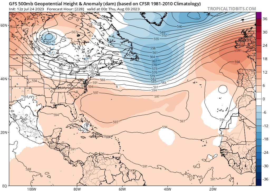
Thread about the next potential MDR/central Atlantic system. Of course it's very early and the system isn't expected to form for another 5-7 days, but I though it's worth discussing potential track. I'm not so sure this will form as early as ensembles imply. Given the indications of a weakening E US trough/building W Atl ridge first week of Aug, this could work against a clean recurve out to sea.
https://twitter.com/yconsor/status/1683469547716636675
https://twitter.com/yconsor/status/1683470048130740224
https://twitter.com/yconsor/status/1683469547716636675
https://twitter.com/yconsor/status/1683470048130740224
2 likes
-
jlauderdal
- S2K Supporter
- Posts: 7240
- Joined: Wed May 19, 2004 5:46 am
- Location: NE Fort Lauderdale
- Contact:
Re: 2023 Global Model Runs Discussion (Out thru day 16)
jconsor wrote:Thread about the next potential MDR/central Atlantic system. Of course it's very early and the system isn't expected to form for another 5-7 days, but I though it's worth discussing potential track. I'm not so sure this will form as early as ensembles imply. Given the indications of a weakening E US trough/building W Atl ridge first week of Aug, this could work against a clean recurve out to sea.
https://twitter.com/yconsor/status/1683469547716636675
https://twitter.com/yconsor/status/1683470048130740224
The July lull is about over and it will be busy the rest of the way. Start your generators now and make sure you are ready, this is the time.
2 likes
-
OuterBanker
- S2K Supporter
- Posts: 1761
- Joined: Wed Feb 26, 2003 10:53 am
- Location: Nags Head, NC
- Contact:
Re: 2023 Global Model Runs Discussion (Out thru day 16)
GFS is on some serious drugs.
06z today https://www.tropicaltidbits.com/analysi ... 406&fh=318
Yesterday 12z https://www.tropicaltidbits.com/analysi ... 312&fh=342
06z today https://www.tropicaltidbits.com/analysi ... 406&fh=318
Yesterday 12z https://www.tropicaltidbits.com/analysi ... 312&fh=342
1 likes
Re: 2023 Global Model Runs Discussion (Out thru day 16)
0z EPS quite active with both the MDR wave and the subtropical system:
6z GEFS also maintains the active signal from 0z:
6z GEFS also maintains the active signal from 0z:
1 likes
TC naming lists: retirements and intensity
Most aggressive Advisory #1's in North Atlantic (cr. kevin for starting the list)
Most aggressive Advisory #1's in North Atlantic (cr. kevin for starting the list)
Re: 2023 Global Model Runs Discussion (Out thru day 16)
The 12Z ICON is similar to the runs from 12 and 24 hours prior with a weak low NE of the LAs and in a position when considering the incoming weakness to just off the CONUS east coast that suggests that a recurve east of the CONUS would be favored if it were to develop. But that's still 7 days out and thus could change.
0 likes
Personal Forecast Disclaimer:
The posts in this forum are NOT official forecasts and should not be used as such. They are just the opinion of the poster and may or may not be backed by sound meteorological data. They are NOT endorsed by any professional institution or storm2k.org. For official information, please refer to the NHC and NWS products.
The posts in this forum are NOT official forecasts and should not be used as such. They are just the opinion of the poster and may or may not be backed by sound meteorological data. They are NOT endorsed by any professional institution or storm2k.org. For official information, please refer to the NHC and NWS products.
Re: 2023 Global Model Runs Discussion (Out thru day 16)
The 12Z CMC has a similar recurve well E of the US. OTOH, the 12Z GFS has a weak low that tracks further SW and would be in a much more threatening position to the CONUS in early August should it subsequently develop.
0 likes
Personal Forecast Disclaimer:
The posts in this forum are NOT official forecasts and should not be used as such. They are just the opinion of the poster and may or may not be backed by sound meteorological data. They are NOT endorsed by any professional institution or storm2k.org. For official information, please refer to the NHC and NWS products.
The posts in this forum are NOT official forecasts and should not be used as such. They are just the opinion of the poster and may or may not be backed by sound meteorological data. They are NOT endorsed by any professional institution or storm2k.org. For official information, please refer to the NHC and NWS products.
-
Blown Away

- S2K Supporter
- Posts: 10253
- Joined: Wed May 26, 2004 6:17 am
Re: 2023 Global Model Runs Discussion (Out thru day 16)
12z GFS…
0 likes
Hurricane Eye Experience: David 79, Irene 99, Frances 04, Jeanne 04, Wilma 05… Hurricane Brush Experience: Andrew 92, Erin 95, Floyd 99, Matthew 16, Irma 17, Ian 22, Nicole 22…
-
jlauderdal
- S2K Supporter
- Posts: 7240
- Joined: Wed May 19, 2004 5:46 am
- Location: NE Fort Lauderdale
- Contact:
Re: RE: Re: 2023 Global Model Runs Discussion (Out thru day 16)
The gfs with the required sofla strikeBlown Away wrote:
12z GFS…
1 likes
-
SFLcane

- S2K Supporter
- Posts: 10281
- Age: 48
- Joined: Sat Jun 05, 2010 1:44 pm
- Location: Lake Worth Florida
-
cycloneye

- Admin

- Posts: 149505
- Age: 69
- Joined: Thu Oct 10, 2002 10:54 am
- Location: San Juan, Puerto Rico
Re: 2023 Global Model Runs Discussion (Out thru day 16)
https://twitter.com/AndyHazelton/status/1683527376070922240
@AndyHazelton
The next wave moving into the Atlantic will definitely have a large-scale setup that suggests it should develop at some point. Favorable CCKW interaction, large anticyclone overhead, solid moisture field. As we saw with #95L though, sustained convection will be important.
The next wave moving into the Atlantic will definitely have a large-scale setup that suggests it should develop at some point. Favorable CCKW interaction, large anticyclone overhead, solid moisture field. As we saw with #95L though, sustained convection will be important.
0 likes
Visit the Caribbean-Central America Weather Thread where you can find at first post web cams,radars
and observations from Caribbean basin members Click Here
and observations from Caribbean basin members Click Here
Re: 2023 Global Model Runs Discussion (Out thru day 16)
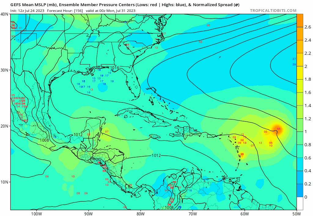
12Z GEFS has an impressive/worrisome 11 Hs out of 31 members from the AEW now near the African coast. That's the most I've counted as the 0Z GEFS had 10 by my count. So far in the run, one hits the US (FL E coast) with more possible as the run goes further.
Update further in run: so far 3 H hit US (2 FL, 1 NC).
Update further in run: so far 3 H hit US (2 FL, 1 NC).
1 likes
Personal Forecast Disclaimer:
The posts in this forum are NOT official forecasts and should not be used as such. They are just the opinion of the poster and may or may not be backed by sound meteorological data. They are NOT endorsed by any professional institution or storm2k.org. For official information, please refer to the NHC and NWS products.
The posts in this forum are NOT official forecasts and should not be used as such. They are just the opinion of the poster and may or may not be backed by sound meteorological data. They are NOT endorsed by any professional institution or storm2k.org. For official information, please refer to the NHC and NWS products.
-
SFLcane
- S2K Supporter
- Posts: 10281
- Age: 48
- Joined: Sat Jun 05, 2010 1:44 pm
- Location: Lake Worth Florida
Re: 2023 Global Model Runs Discussion (Out thru day 16)
LarryWx wrote:12Z GEFS has an impressive/worrisome 11 Hs out of 31 members from the AEW now near the African coast. That's the most I've counted as the 0Z GEFS had 10 by my count. So far in the run, one hits the US (FL E coast) with more possible as the run goes further.
Update further in run: so far 3 H hit US (2 FL, 1 NC).
Furthest west the GEFS has been.
2 likes
-
Blown Away
- S2K Supporter
- Posts: 10253
- Joined: Wed May 26, 2004 6:17 am
Re: 2023 Global Model Runs Discussion (Out thru day 16)
SFLcane wrote:LarryWx wrote:12Z GEFS has an impressive/worrisome 11 Hs out of 31 members from the AEW now near the African coast. That's the most I've counted as the 0Z GEFS had 10 by my count. So far in the run, one hits the US (FL E coast) with more possible as the run goes further.
Update further in run: so far 3 H hit US (2 FL, 1 NC).
Furthest west the GEFS has been.
Very active 12z GEFS, GOM to OTS…
1 likes
Hurricane Eye Experience: David 79, Irene 99, Frances 04, Jeanne 04, Wilma 05… Hurricane Brush Experience: Andrew 92, Erin 95, Floyd 99, Matthew 16, Irma 17, Ian 22, Nicole 22…
-
SFLcane
- S2K Supporter
- Posts: 10281
- Age: 48
- Joined: Sat Jun 05, 2010 1:44 pm
- Location: Lake Worth Florida
Re: 2023 Global Model Runs Discussion (Out thru day 16)
Blown Away wrote:SFLcane wrote:LarryWx wrote:12Z GEFS has an impressive/worrisome 11 Hs out of 31 members from the AEW now near the African coast. That's the most I've counted as the 0Z GEFS had 10 by my count. So far in the run, one hits the US (FL E coast) with more possible as the run goes further.
Update further in run: so far 3 H hit US (2 FL, 1 NC).
Furthest west the GEFS has been.
[url]https://i.postimg.cc/15hyRSs3/gfs-ememb-lowlocs-watl-fh156-342.gif [/url]
Very active 12z GEFS, GOM to OTS…
Most still recurve near Bermuda.
0 likes
-
SFLcane
- S2K Supporter
- Posts: 10281
- Age: 48
- Joined: Sat Jun 05, 2010 1:44 pm
- Location: Lake Worth Florida
Re: 2023 Global Model Runs Discussion (Out thru day 16)
ECMWF says there is nothing to see here. CMC did jump onboard so well see
0 likes
Who is online
Users browsing this forum: Google [Bot], StPeteMike, WaveBreaking and 282 guests