
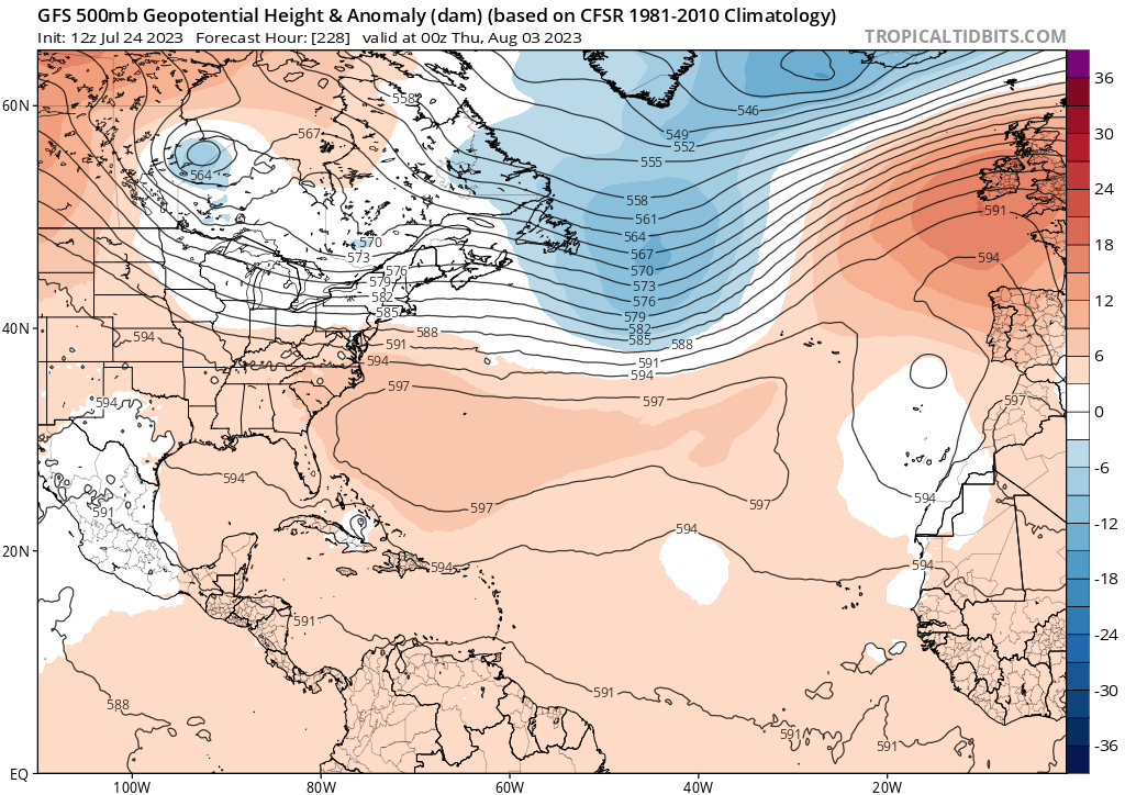
That's some heavy duty ridging. With that orientation and those 597 heights, it's easy to see the potential risk for the Atlantic seaboard. The next anticipated wave off Africa may be a bit too quick across the pond to get trapped westward. Perhaps that's why CMC & ICON has the reflection gaining latitude and recurving from the get-go. As is the case every year - timing is everything.
2023 Global Model Runs Discussion (Out thru day 16)
Moderator: S2k Moderators
Forum rules

The posts in this forum are NOT official forecasts and should not be used as such. They are just the opinion of the poster and may or may not be backed by sound meteorological data. They are NOT endorsed by any professional institution or STORM2K. For official information, please refer to products from the National Hurricane Center and National Weather Service.
Re: 2023 Global Model Runs Discussion (Out thru day 16)
That's some heavy duty ridging. With that orientation and those 597 heights, it's easy to see the potential risk for the Atlantic seaboard. The next anticipated wave off Africa may be a bit too quick across the pond to get trapped westward. Perhaps that's why CMC & ICON has the reflection gaining latitude and recurving from the get-go. As is the case every year - timing is everything.
2 likes
Andy D
(For official information, please refer to the NHC and NWS products.)
(For official information, please refer to the NHC and NWS products.)
Re: 2023 Global Model Runs Discussion (Out thru day 16)
SFLcane wrote:Blown Away wrote:SFLcane wrote:
Furthest west the GEFS has been.
[url]https://i.postimg.cc/15hyRSs3/gfs-ememb-lowlocs-watl-fh156-342.gif [/url]
Very active 12z GEFS, GOM to OTS…
Most still recurve near Bermuda.
Adrian,
This is how I would describe it. Of the 22% (11) with hurricanes, the tracks are fairly evenly distributed from just E of Bermuda to the SE US since 3 of 11 hit SE US and a 4th only barely stays offshore.
1 likes
Personal Forecast Disclaimer:
The posts in this forum are NOT official forecasts and should not be used as such. They are just the opinion of the poster and may or may not be backed by sound meteorological data. They are NOT endorsed by any professional institution or storm2k.org. For official information, please refer to the NHC and NWS products.
The posts in this forum are NOT official forecasts and should not be used as such. They are just the opinion of the poster and may or may not be backed by sound meteorological data. They are NOT endorsed by any professional institution or storm2k.org. For official information, please refer to the NHC and NWS products.
-
SFLcane

- S2K Supporter

- Posts: 10281
- Age: 48
- Joined: Sat Jun 05, 2010 1:44 pm
- Location: Lake Worth Florida
Re: 2023 Global Model Runs Discussion (Out thru day 16)
LarryWx wrote:SFLcane wrote:Blown Away wrote:
[url]https://i.postimg.cc/15hyRSs3/gfs-ememb-lowlocs-watl-fh156-342.gif [/url]
Very active 12z GEFS, GOM to OTS…
Most still recurve near Bermuda.
Adrian,
This is how I would describe it. Of the 22% (11) with hurricanes, the tracks are fairly evenly distributed from just E of Bermuda to the SE US since 3 of 11 hit SE US and a 4th only barely stays offshore.
0 likes
-
Spacecoast

- Category 2

- Posts: 773
- Joined: Thu Aug 31, 2017 2:03 pm
Re: 2023 Global Model Runs Discussion (Out thru day 16)
12z GEFS: 34+ Gust probability (from Tomer Burg's site).

!2z EPS shows early curve...

!2z EPS shows early curve...
Last edited by Spacecoast on Mon Jul 24, 2023 2:53 pm, edited 1 time in total.
1 likes
-
wxman57

- Moderator-Pro Met

- Posts: 23175
- Age: 68
- Joined: Sat Jun 21, 2003 8:06 pm
- Location: Houston, TX (southwest)
Re: 2023 Global Model Runs Discussion (Out thru day 16)
EC, CMC, and ICON all keep it weak and turn it northward before reaching the NE Caribbean. GFS makes it a TS that strikes SE Florida in 10.5 days. Once again, it's the outlier. Don't trust the GFS.
4 likes
-
jlauderdal
- S2K Supporter
- Posts: 7240
- Joined: Wed May 19, 2004 5:46 am
- Location: NE Fort Lauderdale
- Contact:
Re: RE: Re: 2023 Global Model Runs Discussion (Out thru day 16)
The gfs sending a hurricane to sofla is on par with the hwrf making majors, its expected to happen multiple times a season regardlesswxman57 wrote:EC, CMC, and ICON all keep it weak and turn it northward before reaching the NE Caribbean. GFS makes it a TS that strikes SE Florida in 10.5 days. Once again, it's the outlier. Don't trust the GFS.
0 likes
-
wxman57
- Moderator-Pro Met
- Posts: 23175
- Age: 68
- Joined: Sat Jun 21, 2003 8:06 pm
- Location: Houston, TX (southwest)
Re: 2023 Global Model Runs Discussion (Out thru day 16)
18Z GFS is coming to its senses - just a weak low that dissipates.
2 likes
-
Blown Away

- S2K Supporter
- Posts: 10253
- Joined: Wed May 26, 2004 6:17 am
Re: 2023 Global Model Runs Discussion (Out thru day 16)
wxman57 wrote:18Z GFS is coming to its senses - just a weak low that dissipates.
Models into early August with very little activity. Do you think El Niño starts to influence more from September on? When do you think we see these threats to SFL, Central GOM, Yucatán you talked about?
0 likes
Hurricane Eye Experience: David 79, Irene 99, Frances 04, Jeanne 04, Wilma 05… Hurricane Brush Experience: Andrew 92, Erin 95, Floyd 99, Matthew 16, Irma 17, Ian 22, Nicole 22…
-
Kingarabian

- S2K Supporter
- Posts: 16366
- Joined: Sat Aug 08, 2009 3:06 am
- Location: Honolulu, Hawaii
Re: 2023 Global Model Runs Discussion (Out thru day 16)
Anything that goes above the islands will be favored to become a TC. Much more than entering the Caribbean.
2 likes
RIP Kobe Bryant
-
Category5Kaiju

- Category 5

- Posts: 4334
- Joined: Thu Dec 24, 2020 12:45 pm
- Location: Seattle and Phoenix
Re: 2023 Global Model Runs Discussion (Out thru day 16)
Looks like season's not canceled after all (I'm talking to you, 00Z GFS  )
)
0 likes
Unless explicitly stated, all info in my posts is based on my own opinions and observations. Tropical storms and hurricanes can be extremely dangerous. Refer to an accredited weather research agency or meteorologist if you need to make serious decisions regarding an approaching storm.
-
REDHurricane

- Category 1

- Posts: 438
- Age: 28
- Joined: Sun Jul 03, 2022 2:36 pm
- Location: Northeast Pacific Ocean
Re: 2023 Global Model Runs Discussion (Out thru day 16)
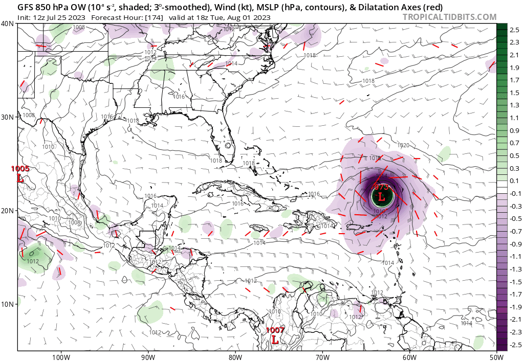
0z EPS and 6z GEFS showing decently strong signals of development from both the tropical wave currently entering the MDR and (the remnants of?) 95L in the western Caribbean just 5 days out


1 likes
-
wxman57
- Moderator-Pro Met
- Posts: 23175
- Age: 68
- Joined: Sat Jun 21, 2003 8:06 pm
- Location: Houston, TX (southwest)
Re: 2023 Global Model Runs Discussion (Out thru day 16)
0Z GFS just couldn't help itself in developing the wave by Africa into a hurricane off the East U.S. Coast. 06Z GFS is more reasonable - no development or very weak development, as per other models.
0 likes

Re: 2023 Global Model Runs Discussion (Out thru day 16)
12z GFS back on board with development of Emily from our MDR AOI, which starts forming earlier than the past 6 runs on hour 108. Brings it down to a 979 mb hurricane North of the LA at hour 162.
0 likes

Re: 2023 Global Model Runs Discussion (Out thru day 16)
Starting to get into fantasy territory, but the 12z GFS starts building in a ridge just as it comes near the SE states (Hour 240).
1 likes
-
SFLcane
- S2K Supporter
- Posts: 10281
- Age: 48
- Joined: Sat Jun 05, 2010 1:44 pm
- Location: Lake Worth Florida
Re: 2023 Global Model Runs Discussion (Out thru day 16)
Woofde wrote:Starting to get into fantasy territory, but the 12z GFS starts building in a ridge just as it comes near the SE states (Hour 240).
crazy how it just misses but you cant bet on that.

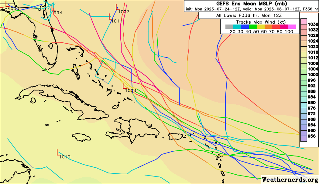
Uptick on the 12z GEFS
Last edited by SFLcane on Tue Jul 25, 2023 12:14 pm, edited 1 time in total.
0 likes

Re: 2023 Global Model Runs Discussion (Out thru day 16)
SFLcane wrote:Woofde wrote:Starting to get into fantasy territory, but the 12z GFS starts building in a ridge just as it comes near the SE states (Hour 240).
crazy how it just misses bit you cant bet on that.
Uptick on the 12z GEFS
https://i.postimg.cc/zvmSVdmX/gfs.gif
florida force field being tested early.....
0 likes
Re: 2023 Global Model Runs Discussion (Out thru day 16)
SFLcane wrote:Woofde wrote:Starting to get into fantasy territory, but the 12z GFS starts building in a ridge just as it comes near the SE states (Hour 240).
crazy how it just misses bit you cant bet on that.
Uptick on the 12z GEFS
https://i.postimg.cc/zvmSVdmX/gfs.gif
Adrian, thanks for posting this. I agree 100% that you can't count on the miss. But even more, I'm betting wxman57 and others (including you and me) are probably thinking you can't count on the GFS' idea of having a nearby major hurricane that closeby then in the first place. I know you're not but thought I'd get that out of the way. With this setup in the unlikely event that a MH should actually develop, the chances of it recurving that close to the SE US would be low imho.
Last edited by LarryWx on Tue Jul 25, 2023 12:08 pm, edited 3 times in total.
1 likes
Personal Forecast Disclaimer:
The posts in this forum are NOT official forecasts and should not be used as such. They are just the opinion of the poster and may or may not be backed by sound meteorological data. They are NOT endorsed by any professional institution or storm2k.org. For official information, please refer to the NHC and NWS products.
The posts in this forum are NOT official forecasts and should not be used as such. They are just the opinion of the poster and may or may not be backed by sound meteorological data. They are NOT endorsed by any professional institution or storm2k.org. For official information, please refer to the NHC and NWS products.
-
toad strangler

- S2K Supporter
- Posts: 4546
- Joined: Sun Jul 28, 2013 3:09 pm
- Location: Earth
- Contact:
Re: 2023 Global Model Runs Discussion (Out thru day 16)
SFLcane wrote:Woofde wrote:Starting to get into fantasy territory, but the 12z GFS starts building in a ridge just as it comes near the SE states (Hour 240).
crazy how it just misses bit you cant bet on that.
Uptick on the 12z GEFS
https://i.postimg.cc/zvmSVdmX/gfs.gif
That's a climo super highway track if I ever saw one!
0 likes
My Weather Station
https://www.wunderground.com/dashboard/pws/KFLPORTS603
https://www.wunderground.com/dashboard/pws/KFLPORTS603
Who is online
Users browsing this forum: Ulf and 175 guests