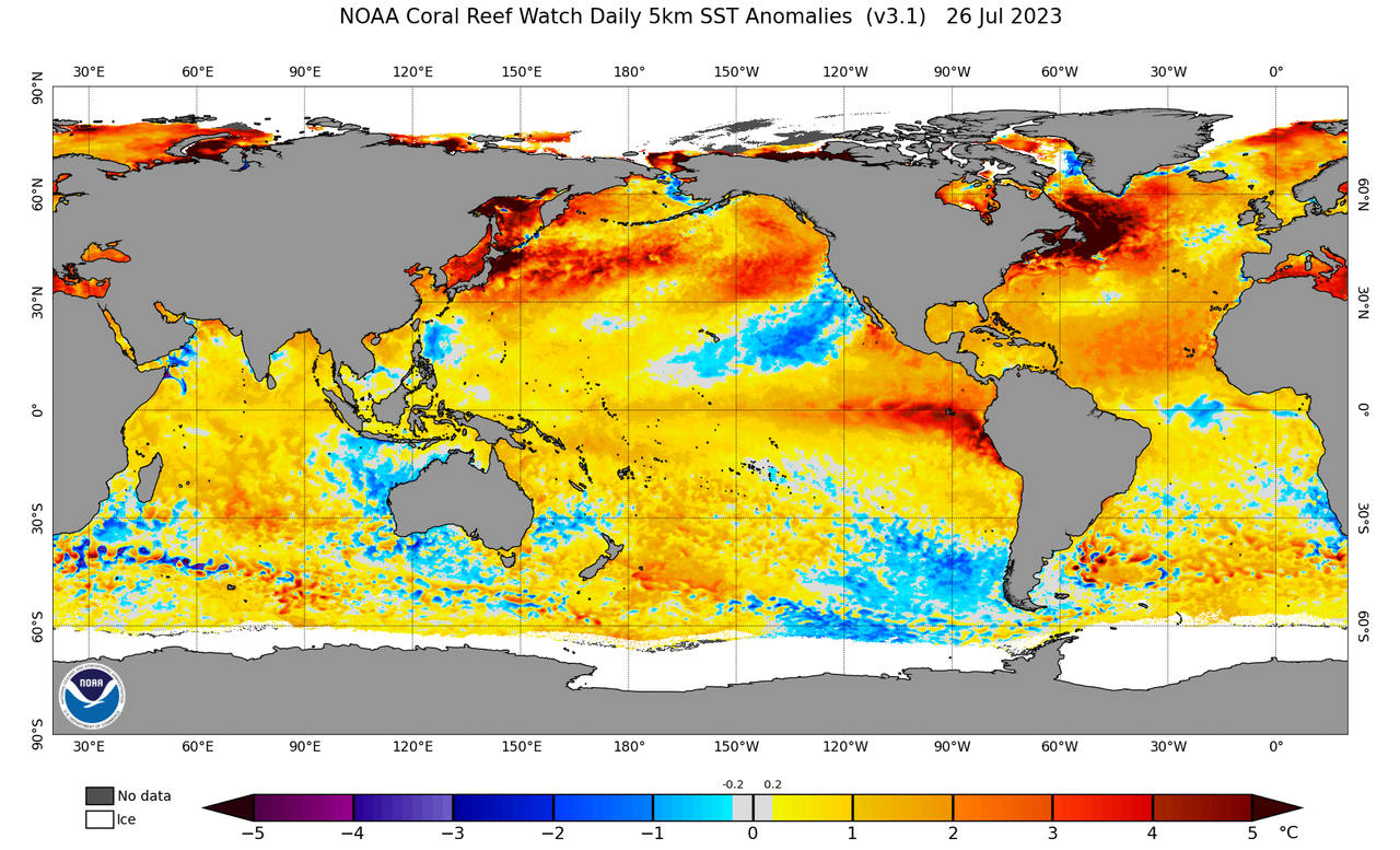
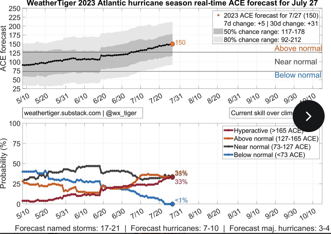
2023 Indicators (SST, SAL, MSLP, Wind shear, Steering, Instability) and Day 16+ Models

This is the general tropical discussion area. Anyone can take their shot at predicting a storms path.

Moderator: S2k Moderators

Forum rules

The posts in this forum are NOT official forecasts and should not be used as such. They are just the opinion of the poster and may or may not be backed by sound meteorological data. They are NOT endorsed by any professional institution or STORM2K. For official information, please refer to products from the National Hurricane Center and National Weather Service.

Help Support Storm2K
Message
Author
User avatar
SFLcane
S2K Supporter
S2K Supporter
Posts: 10163
Age: 47
Joined: Sat Jun 05, 2010 1:44 pm
Location: Lake Worth Florida

Re: 2023 Indicators (SST, SAL, MSLP, Wind shear, Steering, Instability) and Day 16+ Models

#981 Postby SFLcane » Thu Jul 27, 2023 1:30 pm

CyclonicFury wrote:
SFLcane wrote:
CyclonicFury wrote:As we get closer to the start of August, we'll probably start seeing more season canceling, especially from Andy Hazelton. :wink: July averages 1-2 storms and a hurricane about once every 2-3 years, and we already had a hurricane (Don) with potentially one more storm before the month ends. At the moment, the Atlantic is above average in named storms, hurricanes, and ACE (and major hurricanes before August are very rare to begin with, so it's not surprising we haven't had one yet).

But from a serious perspective, in my opinion, the time where it becomes reasonable to question whether a season will underperform expectations is around the last week of August. We're still about a month away from that time. 2016, 2017, 2019, 2020, and 2021 all had their first major hurricane around the last 10 days of August, so that is close to the average. August is on average the second-most active month in the Atlantic basin, though a lot of that activity occurs in the last third of the month. Every year we often see several MDR systems on the models earlier in the season, and they often underperform or don't form at all, leading to the illusion that the MDR is anomalously hostile and will be all season. We also hear all this discussion about how unusually stable the MDR is when it's mainly just unfavorable climo. As I noted a few days ago, the window for strong MDR storms seems to be limited to around August 20-September 30. Even 2010 and 2017, two of the strongest MDR seasons, didn't have any MDR hurricanes before the last third of August. I'd be very surprised if we saw a hurricane in the MDR proper before the last third of August, even if models may show it happen.


Its only July 27th... :roll:

https://twitter.com/AndyHazelton/status/1684594862040219648?s=20

July is rarely ever "kind" to the MDR to begin with. Systems like Bertha 1996, Emily 2005 and Bertha 2008 are the exception, not the norm. I don't get why Andy is often trying to insinuate the hostility of the MDR so far this month is unusual when it's very much normal. Even some hyperactive seasons in the 1990s and 2000s didn't have anything in the MDR in July.

August I agree with Hazelton on. We haven't had a single hurricane in the MDR east of the Caribbean during August since Irma in 2017, which was on the very last day of the month.


Some can't help themselves but to downcast. I have a few screenshots saved from social media ready to be used when the season is over. :wink:
9 likes   

OuterBanker
S2K Supporter
S2K Supporter
Posts: 1731
Joined: Wed Feb 26, 2003 10:53 am
Location: Nags Head, NC
Contact:

Re: 2023 Indicators (SST, SAL, MSLP, Wind shear, Steering, Instability) and Day 16+ Models

#982 Postby OuterBanker » Thu Jul 27, 2023 2:22 pm

Been on the OBX for 49 yrs. Don't think I've ever seen the water temp at 89 degrees. This temp is at just shy of 36N.
Thank God nothing is coming this way.
GFS has come to it's senses weak low caught in 60 w trough.
The 360 hr really needs rehab. It's been hallucinating all season.
3 likes   

LarryWx
S2K Supporter
S2K Supporter
Posts: 6309
Joined: Sun Sep 07, 2003 2:04 pm
Location: GA

Re: 2023 Indicators (SST, SAL, MSLP, Wind shear, Steering, Instability) and Day 16+ Models

#983 Postby LarryWx » Thu Jul 27, 2023 2:23 pm

Average number of storms that had TCG in July during satellite era when El Niño (prior to 2023) with +1.0+ JJA ONI: 0.80

Only 1997 (3) and 2015 (1) had any. I think JJA of 2023 ONI will be +1.0+.
1 likes   
Personal Forecast Disclaimer:
The posts in this forum are NOT official forecasts and should not be used as such. They are just the opinion of the poster and may or may not be backed by sound meteorological data. They are NOT endorsed by any professional institution or storm2k.org. For official information, please refer to the NHC and NWS products.

User avatar
Emmett_Brown
Category 5
Category 5
Posts: 1432
Joined: Wed Aug 24, 2005 9:10 pm
Location: Sarasota FL

Re: 2023 Indicators (SST, SAL, MSLP, Wind shear, Steering, Instability) and Day 16+ Models

#984 Postby Emmett_Brown » Thu Jul 27, 2023 2:40 pm

July is the most misunderstood month of the hurricane season. As many have pointed out, what happens in July has almost no bearing on how the season turns out overall. And, most seasons, stable July conditions usually persist until mid/late August. Anomalously warm water temps with a Nino could make things interesting, but that remains to be seen. The tropical wave near FL today is a great example. Water temps are near record highs, and the stable July air is completely in charge.
2 likes   

User avatar
AnnularCane
S2K Supporter
S2K Supporter
Posts: 2862
Joined: Thu Jun 08, 2006 9:18 am
Location: Wytheville, VA

Re: 2023 Indicators (SST, SAL, MSLP, Wind shear, Steering, Instability) and Day 16+ Models

#985 Postby AnnularCane » Thu Jul 27, 2023 3:42 pm

CyclonicFury wrote:
SFLcane wrote:
CyclonicFury wrote:Systems like Bertha 1996, Emily 2005 and Bertha 2008 are the exception, not the norm.


Maybe this one should be another exception to continue the pattern. :lol:
0 likes   
"But it never rained rain. It never snowed snow. And it never blew just wind. It rained things like soup and juice. It snowed mashed potatoes and green peas. And sometimes the wind blew in storms of hamburgers." -- Judi Barrett, Cloudy with a Chance of Meatballs

User avatar
gatorcane
S2K Supporter
S2K Supporter
Posts: 23691
Age: 47
Joined: Sun Mar 13, 2005 3:54 pm
Location: Boca Raton, FL

Re: 2023 Indicators (SST, SAL, MSLP, Wind shear, Steering, Instability) and Day 16+ Models

#986 Postby gatorcane » Thu Jul 27, 2023 7:35 pm

Global models continue to show trough after trough moving through the Eastern United States over the next 10 days and even beyond. From a climo standpoint, we should be seeing our strongest ridging now. The Bermuda High has been weak this year so far as well as those in Florida can attest to with a general west to SW wind flow pushing storms to the east coast during the afternoon (for the most part). My thinking is that the El Niño or something with the global SST configuration has shifted the pattern and that we could see more troughiness than normal over the Eastern United States and Western Atlantic this season. Combined with El Niño generally squashing anything significant in the Caribbean, the high threat zone shouldn’t be the Gulf or Florida this season, at least from a major hurricane. Something sheared or weaker is always possible if the timing is right. The Carolinas and points northward up through Nova Scotia / Eastern Canada could be a bit higher risk as well as Bermuda which usually is each season anyway. We do see those above normal SSTs across the Atlantic but they are way above normal in the North Atlantic near Greenland. Not sure what that means, could mean more activity across the subtropics this year and more “north and east” of the US and Caribbean activity.

Image
Last edited by gatorcane on Thu Jul 27, 2023 7:48 pm, edited 2 times in total.
4 likes   

User avatar
Category5Kaiju
Category 5
Category 5
Posts: 4097
Joined: Thu Dec 24, 2020 12:45 pm
Location: Seattle

Re: 2023 Indicators (SST, SAL, MSLP, Wind shear, Steering, Instability) and Day 16+ Models

#987 Postby Category5Kaiju » Thu Jul 27, 2023 7:45 pm

After enough times tracking the tropics, I think I am pretty informed enough to not fall for season cancel again :lol:

In all seriousness, I think it's still important to know that El Nino years typically feature their strongest storms between the August 20 and September 30 timeframe. Ivan from 2004? September. David from 1979? Late August/Early September. Camille from 1969? Late August. Flora from 1963? Late September. Many more examples exist, and I could go on.
0 likes   
Unless explicitly stated, all info in my posts is based on my own opinions and observations. Tropical storms and hurricanes can be extremely dangerous. Do not think you can beat Mother Nature. Refer to an accredited weather research agency or meteorologist if you need to make serious decisions regarding an approaching storm.

User avatar
Category5Kaiju
Category 5
Category 5
Posts: 4097
Joined: Thu Dec 24, 2020 12:45 pm
Location: Seattle

Re: 2023 Indicators (SST, SAL, MSLP, Wind shear, Steering, Instability) and Day 16+ Models

#988 Postby Category5Kaiju » Thu Jul 27, 2023 7:51 pm

gatorcane wrote:Global models continue to show trough after trough moving through the Eastern United States over the next 10 days and even beyond. From a climo standpoint, we should be seeing our strongest ridging now. The Bermuda High has been weak this year so far as well as those in Florida can attest to with a general west to SW wind flow pushing storms to the east coast during the afternoon (for the most part). My thinking is that the El Niño or something with the global SST configuration has shifted the pattern and that we could see more troughiness than normal over the Eastern United States and Western Atlantic this season. Combined with El Niño generally squashing anything significant in the Caribbean, the high threat zone shouldn’t be the Gulf or Florida this season, at least from a major hurricane. Something sheared or weaker is always possible if the timing is right. The Carolinas and points northward up through Nova Scotia could be a bit higher risk as well as Bermuda which usually is each season anyway. We do see those above normal SSTs across the Atlantic but they are way above normal in the North Atlantic near Greenland. Not sure what that means, could mean more activity across the subtropics this year and more “north and east” of the US and Caribbean activity.

https://i.postimg.cc/QdWVzwm4/ssta-daily-current.png


Good points, though I would like to add that it's always important to be alert and ready because you can always have a storm that "slips through the cracks." At least from a Florida perspective, a good example of this is the 1935 season, when there was a classic, trough-based recurving Category 4 hurricane that did not affect any landmasses, followed by the infamous Labor Day Hurricane (which formed just east of the Bahamas and drifted west). Steering patterns are very dynamic, so who knows what would really happen in the end? Also, I wonder what that huge body of dark red off Eastern Canada signifies; isn't that supposed to be the result of some strong high pressure system?
2 likes   
Unless explicitly stated, all info in my posts is based on my own opinions and observations. Tropical storms and hurricanes can be extremely dangerous. Do not think you can beat Mother Nature. Refer to an accredited weather research agency or meteorologist if you need to make serious decisions regarding an approaching storm.

User avatar
Ntxw
Storm2k Moderator
Storm2k Moderator
Posts: 22786
Joined: Wed Oct 21, 2009 6:34 pm
Location: DFW, Texas

Re: 2023 Indicators (SST, SAL, MSLP, Wind shear, Steering, Instability) and Day 16+ Models

#989 Postby Ntxw » Thu Jul 27, 2023 8:03 pm

gatorcane wrote:Global models continue to show trough after trough moving through the Eastern United States over the next 10 days and even beyond. From a climo standpoint, we should be seeing our strongest ridging now. The Bermuda High has been weak this year so far as well as those in Florida can attest to with a general west to SW wind flow pushing storms to the east coast during the afternoon (for the most part). My thinking is that the El Niño or something with the global SST configuration has shifted the pattern and that we could see more troughiness than normal over the Eastern United States and Western Atlantic this season. Combined with El Niño generally squashing anything significant in the Caribbean, the high threat zone shouldn’t be the Gulf or Florida this season, at least from a major hurricane. Something sheared or weaker is always possible if the timing is right. The Carolinas and points northward up through Nova Scotia could be a bit higher risk as well as Bermuda which usually is each season anyway. We do see those above normal SSTs across the Atlantic but they are way above normal in the North Atlantic near Greenland. Not sure what that means, could mean more activity across the subtropics this year and more “north and east” of the US and Caribbean activity.

https://i.postimg.cc/QdWVzwm4/ssta-daily-current.png


While there are other mixed mid latitude trough/ridge configurations, a ridge in the PAC NW and trough over the Great Lakes/E-US is consistent with modern El Ninos. The difference this year is out in the North Pacific/Aleutians where some Nina-like ridge still in place likely from lack of cpac coupling.

Image

Image
2 likes   
The above post and any post by Ntxw is NOT an official forecast and should not be used as such. It is just the opinion of the poster and may or may not be backed by sound meteorological data. It is NOT endorsed by any professional institution including Storm2k. For official information, please refer to NWS products.

  Help support Storm2K!
Help Support Storm2K

User avatar
SFLcane
S2K Supporter
S2K Supporter
Posts: 10163
Age: 47
Joined: Sat Jun 05, 2010 1:44 pm
Location: Lake Worth Florida

Re: 2023 Indicators (SST, SAL, MSLP, Wind shear, Steering, Instability) and Day 16+ Models

#990 Postby SFLcane » Thu Jul 27, 2023 10:14 pm

gatorcane wrote:Global models continue to show trough after trough moving through the Eastern United States over the next 10 days and even beyond. From a climo standpoint, we should be seeing our strongest ridging now. The Bermuda High has been weak this year so far as well as those in Florida can attest to with a general west to SW wind flow pushing storms to the east coast during the afternoon (for the most part). My thinking is that the El Niño or something with the global SST configuration has shifted the pattern and that we could see more troughiness than normal over the Eastern United States and Western Atlantic this season. Combined with El Niño generally squashing anything significant in the Caribbean, the high threat zone shouldn’t be the Gulf or Florida this season, at least from a major hurricane. Something sheared or weaker is always possible if the timing is right. The Carolinas and points northward up through Nova Scotia / Eastern Canada could be a bit higher risk as well as Bermuda which usually is each season anyway. We do see those above normal SSTs across the Atlantic but they are way above normal in the North Atlantic near Greenland. Not sure what that means, could mean more activity across the subtropics this year and more “north and east” of the US and Caribbean activity.

https://i.postimg.cc/QdWVzwm4/ssta-daily-current.png


So should we cancel the season? That’s is an Impossible call to make in my opinion in late July. Things can change and unfortunately as stated by wxman57 there will be times when storms will not turn. Taking a peak at the long range gfs and cfs.

Image

Image
1 likes   

User avatar
SFLcane
S2K Supporter
S2K Supporter
Posts: 10163
Age: 47
Joined: Sat Jun 05, 2010 1:44 pm
Location: Lake Worth Florida

Re: 2023 Indicators (SST, SAL, MSLP, Wind shear, Steering, Instability) and Day 16+ Models

#991 Postby SFLcane » Thu Jul 27, 2023 10:17 pm

Weathertigers seasonal model now up to 150+ ace and climbing for the season. Not too shabby again for a strengthening El Niño. :D

Image
3 likes   

User avatar
cycloneye
Admin
Admin
Posts: 145355
Age: 68
Joined: Thu Oct 10, 2002 10:54 am
Location: San Juan, Puerto Rico

Re: 2023 Indicators (SST, SAL, MSLP, Wind shear, Steering, Instability) and Day 16+ Models

#992 Postby cycloneye » Thu Jul 27, 2023 10:24 pm

SFLcane wrote:Weathertigers seasonal model now up to 150+ ace and climbing for the season. Not too shabby again for a strengthening El Niño. :D

https://i.postimg.cc/DZ0XMSJL/IMG-7341.jpg


Here is the link for the peeps that may want to follow the daily updates.

https://weathertiger.substack.com/p/rea ... -hurricane
0 likes   
Visit the Caribbean-Central America Weather Thread where you can find at first post web cams,radars
and observations from Caribbean basin members Click Here

User avatar
SFLcane
S2K Supporter
S2K Supporter
Posts: 10163
Age: 47
Joined: Sat Jun 05, 2010 1:44 pm
Location: Lake Worth Florida

Re: 2023 Indicators (SST, SAL, MSLP, Wind shear, Steering, Instability) and Day 16+ Models

#993 Postby SFLcane » Fri Jul 28, 2023 9:37 am

Wave train will kick into full gear in a few weeks...

Image

Image

Image
3 likes   

User avatar
SFLcane
S2K Supporter
S2K Supporter
Posts: 10163
Age: 47
Joined: Sat Jun 05, 2010 1:44 pm
Location: Lake Worth Florida

Re: 2023 Indicators (SST, SAL, MSLP, Wind shear, Steering, Instability) and Day 16+ Models

#994 Postby SFLcane » Fri Jul 28, 2023 10:01 am

Ecmwf precip distribution for aug14-21.. :double:

Image
1 likes   

User avatar
REDHurricane
Category 1
Category 1
Posts: 396
Age: 27
Joined: Sun Jul 03, 2022 2:36 pm
Location: Northeast Pacific Ocean

Re: 2023 Indicators (SST, SAL, MSLP, Wind shear, Steering, Instability) and Day 16+ Models

#995 Postby REDHurricane » Fri Jul 28, 2023 10:25 am


Very intriguing that the landfall probabilities for this run appear to be centered on Florida instead of heavily favoring recurves as we've seen the past couple of weeks, especially that 20-30% signal in the Gulf -- I'll be interested to see if this becomes a trend or not over the next few runs
0 likes   

User avatar
gatorcane
S2K Supporter
S2K Supporter
Posts: 23691
Age: 47
Joined: Sun Mar 13, 2005 3:54 pm
Location: Boca Raton, FL

Re: 2023 Indicators (SST, SAL, MSLP, Wind shear, Steering, Instability) and Day 16+ Models

#996 Postby gatorcane » Fri Jul 28, 2023 10:50 am

SFLcane wrote:
gatorcane wrote:Global models continue to show trough after trough moving through the Eastern United States over the next 10 days and even beyond. From a climo standpoint, we should be seeing our strongest ridging now. The Bermuda High has been weak this year so far as well as those in Florida can attest to with a general west to SW wind flow pushing storms to the east coast during the afternoon (for the most part). My thinking is that the El Niño or something with the global SST configuration has shifted the pattern and that we could see more troughiness than normal over the Eastern United States and Western Atlantic this season. Combined with El Niño generally squashing anything significant in the Caribbean, the high threat zone shouldn’t be the Gulf or Florida this season, at least from a major hurricane. Something sheared or weaker is always possible if the timing is right. The Carolinas and points northward up through Nova Scotia / Eastern Canada could be a bit higher risk as well as Bermuda which usually is each season anyway. We do see those above normal SSTs across the Atlantic but they are way above normal in the North Atlantic near Greenland. Not sure what that means, could mean more activity across the subtropics this year and more “north and east” of the US and Caribbean activity.

https://i.postimg.cc/QdWVzwm4/ssta-daily-current.png


So should we cancel the season? That’s is an Impossible call to make in my opinion in late July. Things can change and unfortunately as stated by wxman57 there will be times when storms will not turn. Taking a peak at the long range gfs and cfs.

https://i.postimg.cc/Fz2sGR3r/IMG-7339.gif

https://i.postimg.cc/3wSym3SR/IMG-7340.png


Long-range CFS model through Aug 29th shows mostly weak recurving systems some clipping the NE Caribbean, one gets close to the SE US at the end of the run. Overall pattern looks to be one of recurving storms, quiet Caribbean and Gulf:

https://www.pivotalweather.com/model.ph ... &dpdt=&mc=
0 likes   

User avatar
SFLcane
S2K Supporter
S2K Supporter
Posts: 10163
Age: 47
Joined: Sat Jun 05, 2010 1:44 pm
Location: Lake Worth Florida

Re: 2023 Indicators (SST, SAL, MSLP, Wind shear, Steering, Instability) and Day 16+ Models

#997 Postby SFLcane » Fri Jul 28, 2023 11:19 am

gatorcane wrote:
SFLcane wrote:
gatorcane wrote:Global models continue to show trough after trough moving through the Eastern United States over the next 10 days and even beyond. From a climo standpoint, we should be seeing our strongest ridging now. The Bermuda High has been weak this year so far as well as those in Florida can attest to with a general west to SW wind flow pushing storms to the east coast during the afternoon (for the most part). My thinking is that the El Niño or something with the global SST configuration has shifted the pattern and that we could see more troughiness than normal over the Eastern United States and Western Atlantic this season. Combined with El Niño generally squashing anything significant in the Caribbean, the high threat zone shouldn’t be the Gulf or Florida this season, at least from a major hurricane. Something sheared or weaker is always possible if the timing is right. The Carolinas and points northward up through Nova Scotia / Eastern Canada could be a bit higher risk as well as Bermuda which usually is each season anyway. We do see those above normal SSTs across the Atlantic but they are way above normal in the North Atlantic near Greenland. Not sure what that means, could mean more activity across the subtropics this year and more “north and east” of the US and Caribbean activity.

https://i.postimg.cc/QdWVzwm4/ssta-daily-current.png


So should we cancel the season? That’s is an Impossible call to make in my opinion in late July. Things can change and unfortunately as stated by wxman57 there will be times when storms will not turn. Taking a peak at the long range gfs and cfs.

https://i.postimg.cc/Fz2sGR3r/IMG-7339.gif

https://i.postimg.cc/3wSym3SR/IMG-7340.png


Long-range CFS model through Aug 29th shows mostly weak recurving systems some clipping the NE Caribbean, one gets close to the SE US at the end of the run. Overall pattern looks to be one of recurving storms, quiet Caribbean and Gulf:

https://www.pivotalweather.com/model.ph ... &dpdt=&mc=


Were using 3000 hrs into the future with the CFS oook. We'll see what happens in mid aug.
2 likes   

User avatar
wxman57
Moderator-Pro Met
Moderator-Pro Met
Posts: 22979
Age: 67
Joined: Sat Jun 21, 2003 8:06 pm
Location: Houston, TX (southwest)

Re: 2023 Indicators (SST, SAL, MSLP, Wind shear, Steering, Instability) and Day 16+ Models

#998 Postby wxman57 » Fri Jul 28, 2023 11:51 am

SFLcane wrote:Ecmwf precip distribution for aug14-21.. :double:

https://i.postimg.cc/qMrYfVK8/hh.jpg


That precip anomaly seems to be pointed right at south Florida. Hmm, imagine that...
2 likes   

User avatar
SFLcane
S2K Supporter
S2K Supporter
Posts: 10163
Age: 47
Joined: Sat Jun 05, 2010 1:44 pm
Location: Lake Worth Florida

Re: 2023 Indicators (SST, SAL, MSLP, Wind shear, Steering, Instability) and Day 16+ Models

#999 Postby SFLcane » Fri Jul 28, 2023 12:18 pm

Under attack..

Image
1 likes   

LarryWx
S2K Supporter
S2K Supporter
Posts: 6309
Joined: Sun Sep 07, 2003 2:04 pm
Location: GA

Re: 2023 Indicators (SST, SAL, MSLP, Wind shear, Steering, Instability) and Day 16+ Models

#1000 Postby LarryWx » Fri Jul 28, 2023 1:11 pm

gatorcane wrote:
SFLcane wrote:
gatorcane wrote:Global models continue to show trough after trough moving through the Eastern United States over the next 10 days and even beyond. From a climo standpoint, we should be seeing our strongest ridging now. The Bermuda High has been weak this year so far as well as those in Florida can attest to with a general west to SW wind flow pushing storms to the east coast during the afternoon (for the most part). My thinking is that the El Niño or something with the global SST configuration has shifted the pattern and that we could see more troughiness than normal over the Eastern United States and Western Atlantic this season. Combined with El Niño generally squashing anything significant in the Caribbean, the high threat zone shouldn’t be the Gulf or Florida this season, at least from a major hurricane. Something sheared or weaker is always possible if the timing is right. The Carolinas and points northward up through Nova Scotia / Eastern Canada could be a bit higher risk as well as Bermuda which usually is each season anyway. We do see those above normal SSTs across the Atlantic but they are way above normal in the North Atlantic near Greenland. Not sure what that means, could mean more activity across the subtropics this year and more “north and east” of the US and Caribbean activity.

https://i.postimg.cc/QdWVzwm4/ssta-daily-current.png


So should we cancel the season? That’s is an Impossible call to make in my opinion in late July. Things can change and unfortunately as stated by wxman57 there will be times when storms will not turn. Taking a peak at the long range gfs and cfs.

https://i.postimg.cc/Fz2sGR3r/IMG-7339.gif

https://i.postimg.cc/3wSym3SR/IMG-7340.png


Long-range CFS model through Aug 29th shows mostly weak recurving systems some clipping the NE Caribbean, one gets close to the SE US at the end of the run. Overall pattern looks to be one of recurving storms, quiet Caribbean and Gulf:

https://www.pivotalweather.com/model.ph ... &dpdt=&mc=


It does show them mainly recurving away from the CONUS or dissipating. However, we know that's what most MDR storms do even in August (say ~75%+) with an even higher % doing that during El Niño. But it does also suggest an active August MDR with four closed surface lows (excluding next week's potential). The lack of strong development may be a bias of the model for all I know.

The one in late August near the SE coast along with the extended 7/27 GEFS that Adrian just posted remind me that late August is the start of the climo most active/dangerous period. So, even if there are three August MDR storms 8/7-8/20 that miss the Caribbean and stay way OTS from the CONUS, which is common anyway, it sometimes takes only one for a bad season. Thus the one shown at the end of the CFS in the Caribbean and then near the SE US would be enough to potentially make August, alone, a bad month if something akin to that were to actually occur. August wouldn't be remembered as a quiet month due to the first three if there's a bad one late. And that's not even considering what Sep and Oct might have in store!
0 likes   
Personal Forecast Disclaimer:
The posts in this forum are NOT official forecasts and should not be used as such. They are just the opinion of the poster and may or may not be backed by sound meteorological data. They are NOT endorsed by any professional institution or storm2k.org. For official information, please refer to the NHC and NWS products.


Return to “Talkin' Tropics”

Who is online

Users browsing this forum: No registered users and 27 guests