2023 Global Model Runs Discussion (Out thru day 16)
Moderator: S2k Moderators
Forum rules

The posts in this forum are NOT official forecasts and should not be used as such. They are just the opinion of the poster and may or may not be backed by sound meteorological data. They are NOT endorsed by any professional institution or STORM2K. For official information, please refer to products from the National Hurricane Center and National Weather Service.
-
SFLcane

- S2K Supporter

- Posts: 10281
- Age: 48
- Joined: Sat Jun 05, 2010 1:44 pm
- Location: Lake Worth Florida
Re: 2023 Global Model Runs Discussion (Out thru day 16)
Just made this GIF Tropical cyclone activity (including genesis).
1 likes
-
Category5Kaiju

- Category 5

- Posts: 4345
- Joined: Thu Dec 24, 2020 12:45 pm
- Location: Seattle during the summer, Phoenix during the winter
Re: 2023 Global Model Runs Discussion (Out thru day 16)
SFLcane wrote:Just made this GIF Tropical cyclone activity (including genesis).
https://i.postimg.cc/pd9SRJx1/ecm.gif
Is there a way you could also show the expected dates regarding that gif? Thanks
1 likes
Unless explicitly stated, all information in my posts is based on my own opinions and observations. Tropical storms and hurricanes can be extremely dangerous. Refer to an accredited weather research agency or meteorologist if you need to make serious decisions regarding an approaching storm.
-
SFLcane
- S2K Supporter
- Posts: 10281
- Age: 48
- Joined: Sat Jun 05, 2010 1:44 pm
- Location: Lake Worth Florida
Re: 2023 Global Model Runs Discussion (Out thru day 16)
Category5Kaiju wrote:SFLcane wrote:Just made this GIF Tropical cyclone activity (including genesis).
https://i.postimg.cc/pd9SRJx1/ecm.gif
Is there a way you could also show the expected dates regarding that gif? Thanks
Sure thing 8/6-8/14
0 likes

Re: 2023 Global Model Runs Discussion (Out thru day 16)
SFLcane wrote:Just made this GIF Tropical cyclone activity (including genesis).
https://i.postimg.cc/pd9SRJx1/ecm.gif
Interesting...... should probably take a look at this mornings vis (or IR) E. Atlantic around 11N and 26W
2 likes
Andy D
(For official information, please refer to the NHC and NWS products.)
(For official information, please refer to the NHC and NWS products.)
-
wxman57

- Moderator-Pro Met

- Posts: 23175
- Age: 68
- Joined: Sat Jun 21, 2003 8:06 pm
- Location: Houston, TX (southwest)
Re: RE: Re: 2023 Global Model Runs Discussion (Out thru day 16)
jlauderdal wrote:Lets see what 57 saysBlown Away wrote:https://i.postimg.cc/cLgHF8GW/gfs-mslp-pcpn-watl-fh144-336.gif
06z GFS
https://i.postimg.cc/SKtjd7Jm/Lemon.jpg
I think we should be seeing one of these in the MDR today...
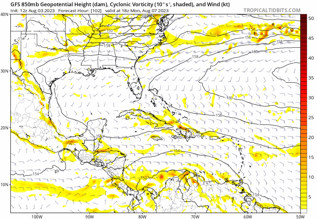
The origin of that GFS hurricane is a wave that's now south of the Cabo Verde Islands. Follow the 850mb vorticity back to today. Satellite imagery indicates a quite strong wave there with good rotation, at least in mid levels. Big question is will it survive and have a shot at developing. Well, I certainly don't believe the GFS' taking a hurricane into south Texas, though many in Texas would welcome a break in the drought. Once again, though, the GFS is completely alone in developing this feature. Beware.

8 likes
Re: RE: Re: 2023 Global Model Runs Discussion (Out thru day 16)
wxman57 wrote:jlauderdal wrote:Lets see what 57 saysBlown Away wrote:https://i.postimg.cc/cLgHF8GW/gfs-mslp-pcpn-watl-fh144-336.gif
06z GFS
https://i.postimg.cc/SKtjd7Jm/Lemon.jpg
I think we should be seeing one of these in the MDR today...
The origin of that GFS hurricane is a wave that's now south of the Cabo Verde Islands. Follow the 850mb vorticity back to today. Satellite imagery indicates a quite strong wave there with good rotation, at least in mid levels. Big question is will it survive and have a shot at developing. Well, I certainly don't believe the GFS' taking a hurricane into south Texas, though many in Texas would welcome a break in the drought. Once again, though, the GFS is completely alone in developing this feature. Beware.
http://wxman57.com/images/wave.JPG
Yes, completely alone in "developing" this feature.... however not alone in reflecting the same feature at 850mb. 0Z run from last night showing JMA at 192 hrs., ICON at 174 hr's and CMC at around 186 hrs. all suggestive of some weak low near or on approach to Puerto Rico. Whether fantom or not, model verification doesn't begin with the first run that the GFS depicts a "fairyland 360 hr landfall". Any spurious long-range landfalls projected by GFS is irrelevant right now. More importantly will be model to model run consistency for actual genesis. Actually, even more important than that will be if this particular feature begins to separate from the ITCZ and maintain its identity in the few days to come.
1 likes
Andy D
(For official information, please refer to the NHC and NWS products.)
(For official information, please refer to the NHC and NWS products.)
-
cycloneye

- Admin

- Posts: 149703
- Age: 69
- Joined: Thu Oct 10, 2002 10:54 am
- Location: San Juan, Puerto Rico
Re: 2023 Global Model Runs Discussion (Out thru day 16)
2 likes
Visit the Caribbean-Central America Weather Thread where you can find at first post web cams,radars
and observations from Caribbean basin members Click Here
and observations from Caribbean basin members Click Here
Re: 2023 Global Model Runs Discussion (Out thru day 16)
12z canadian back at it. Nada on 12z GFS at same timeframe though.

ends up

ends up
Last edited by BobHarlem on Thu Aug 03, 2023 11:34 am, edited 1 time in total.
0 likes
-
SFLcane
- S2K Supporter
- Posts: 10281
- Age: 48
- Joined: Sat Jun 05, 2010 1:44 pm
- Location: Lake Worth Florida
Re: 2023 Global Model Runs Discussion (Out thru day 16)
BobHarlem wrote:12z canadian back at it. Nada on 12z GFS at same timeframe though.
https://i.imgur.com/6Nszg3T.png
https://twitter.com/DerekOrtt/status/1687134471412211712
2 likes
-
Blown Away

- S2K Supporter
- Posts: 10253
- Joined: Wed May 26, 2004 6:17 am
Re: 2023 Global Model Runs Discussion (Out thru day 16)
SFLcane wrote:BobHarlem wrote:12z canadian back at it. Nada on 12z GFS at same timeframe though.
https://i.imgur.com/6Nszg3T.png
https://twitter.com/DerekOrtt/status/1687134471412211712?s=20
12z GFS... Moves a TW just N of Caribbean over SFL and develops over EGOM...
0 likes
Hurricane Eye Experience: David 79, Irene 99, Frances 04, Jeanne 04, Wilma 05… Hurricane Brush Experience: Andrew 92, Erin 95, Floyd 99, Matthew 16, Irma 17, Ian 22, Nicole 22…
-
SFLcane
- S2K Supporter
- Posts: 10281
- Age: 48
- Joined: Sat Jun 05, 2010 1:44 pm
- Location: Lake Worth Florida
Re: 2023 Global Model Runs Discussion (Out thru day 16)
Nothing to see here for now.
000
ABNT20 KNHC 031747
TWOAT
Tropical Weather Outlook
NWS National Hurricane Center Miami FL
200 PM EDT Thu Aug 3 2023
For the North Atlantic...Caribbean Sea and the Gulf of Mexico:
Tropical cyclone formation is not expected in the next 7 days.
$$
Forecaster Hogsett/Beven
000
ABNT20 KNHC 031747
TWOAT
Tropical Weather Outlook
NWS National Hurricane Center Miami FL
200 PM EDT Thu Aug 3 2023
For the North Atlantic...Caribbean Sea and the Gulf of Mexico:
Tropical cyclone formation is not expected in the next 7 days.
$$
Forecaster Hogsett/Beven
1 likes
-
tolakram
- Admin
- Posts: 20186
- Age: 62
- Joined: Sun Aug 27, 2006 8:23 pm
- Location: Florence, KY (name is Mark)
Re: 2023 Global Model Runs Discussion (Out thru day 16)
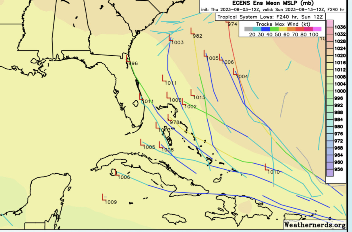
There's a vorticity signal in generally the same place from the 3 big models at 198 hours. That's the important point here IMO, no huge outliers yet. Sure the CMC and eventually the GFS make a model storm out of it but that's not the important part. We'll see if this leads to our first big storm of the season or another ripped up wave.
7 likes
M a r k
- - - - -
Join us in chat: Storm2K Chatroom Invite. Android and IOS apps also available.
The posts in this forum are NOT official forecasts and should not be used as such. Posts are NOT endorsed by any professional institution or STORM2K.org. For official information and forecasts, please refer to NHC and NWS products.

Re: 2023 Global Model Runs Discussion (Out thru day 16)
Was writing this off as a phantom, despite the CMC being relatively bullish for several runs now. This latest run is concerning as a little further north could result in significant development. Anything coming near the Bahamas, South Florida and the Keys with the bathwater temperatures is troubling. Obviously I got development bias for anything near me. The Euro is also showing the wave make to the SE CONUS.
0 likes
-
cycloneye
- Admin
- Posts: 149703
- Age: 69
- Joined: Thu Oct 10, 2002 10:54 am
- Location: San Juan, Puerto Rico
Re: 2023 Global Model Runs Discussion (Out thru day 16)
0 likes
Visit the Caribbean-Central America Weather Thread where you can find at first post web cams,radars
and observations from Caribbean basin members Click Here
and observations from Caribbean basin members Click Here


Re: 2023 Global Model Runs Discussion (Out thru day 16)
It looks like models believe the very dry air to the north will be entrained into the storm and suppress it.


0 likes
Re: RE: Re: 2023 Global Model Runs Discussion (Out thru day 16)
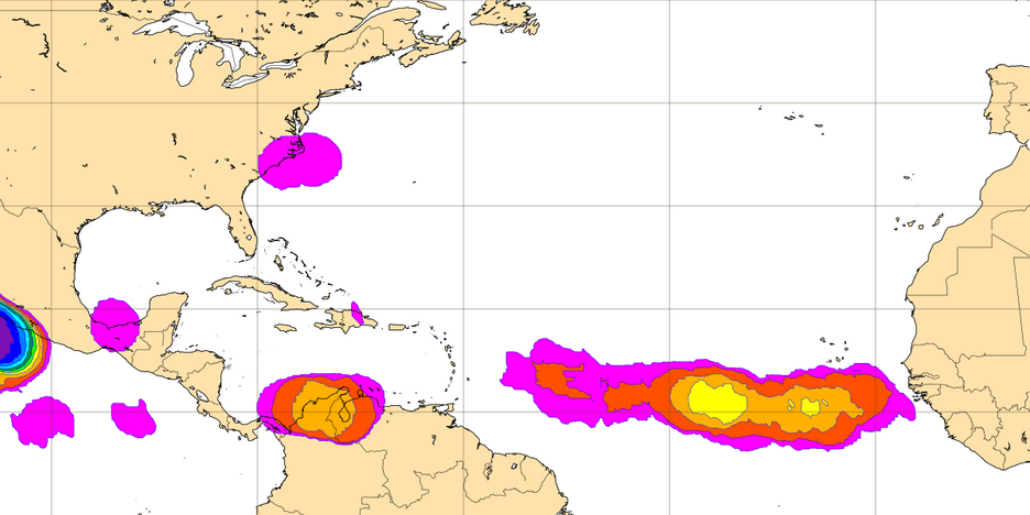
Woofde wrote:It looks like models believe the very dry air to the north will be entrained into the storm and suppress it.https://uploads.tapatalk-cdn.com/20230803/8074e68785d905e1b6cc12cde8cadabe.jpg https://uploads.tapatalk-cdn.com/20230803/c16a75e77f9c0f7a35f9f59e84253998.gifcycloneye wrote:https://twitter.com/AndyHazelton/status/1687190568361734144
hmmmmm, oceanic sand dunes perhaps? Oh that mischievous Uncle Sal.
0 likes
Andy D
(For official information, please refer to the NHC and NWS products.)
(For official information, please refer to the NHC and NWS products.)
-
SouthFLTropics

- Category 5
- Posts: 4258
- Age: 50
- Joined: Thu Aug 14, 2003 8:04 am
- Location: Port St. Lucie, Florida
Re: 2023 Global Model Runs Discussion (Out thru day 16)
While the GFS is not 100% onboard, I have a fair level of concern about a wave getting past 70 west and then finding better conditions. The waters are boiling over there and if something finds the right conditions the potential is very high. The models are showing some sort of activity, albeit, way too early to know for sure in what form. Definitely bears watching. 
3 likes
Fourth Generation Florida Native
Personal Storm History: David 79, Andrew 92, Erin 95, Floyd 99, Irene 99, Frances 04, Jeanne 04, Wilma 05, Matthew 16, Irma 17, Ian 22, Nicole 22, Milton 24
Personal Storm History: David 79, Andrew 92, Erin 95, Floyd 99, Irene 99, Frances 04, Jeanne 04, Wilma 05, Matthew 16, Irma 17, Ian 22, Nicole 22, Milton 24
-
Blown Away
- S2K Supporter
- Posts: 10253
- Joined: Wed May 26, 2004 6:17 am
Re: 2023 Global Model Runs Discussion (Out thru day 16)
12z ECENS… Many TS and a few Cat1-2’s.
1 likes
Hurricane Eye Experience: David 79, Irene 99, Frances 04, Jeanne 04, Wilma 05… Hurricane Brush Experience: Andrew 92, Erin 95, Floyd 99, Matthew 16, Irma 17, Ian 22, Nicole 22…
-
SFLcane
- S2K Supporter
- Posts: 10281
- Age: 48
- Joined: Sat Jun 05, 2010 1:44 pm
- Location: Lake Worth Florida
Re: 2023 Global Model Runs Discussion (Out thru day 16)
SouthFLTropics wrote:While the GFS is not 100% onboard, I have a fair level of concern about a wave getting past 70 west and then finding better conditions. The waters are boiling over there and if something finds the right conditions the potential is very high. The models are showing some sort of activity, albeit, way too early to know for sure in what form. Definitely bears watching.
Surely this Is the main concern here infact anything developing through the next 2 weeks could end in a threatening position in the SW Atlantic with the Environment looking favorable.
1 likes
Who is online
Users browsing this forum: pepecool20 and 159 guests