2023 Global Model Runs Discussion (Out thru day 16)

This is the general tropical discussion area. Anyone can take their shot at predicting a storms path.

Moderator: S2k Moderators

Forum rules

The posts in this forum are NOT official forecasts and should not be used as such. They are just the opinion of the poster and may or may not be backed by sound meteorological data. They are NOT endorsed by any professional institution or STORM2K. For official information, please refer to products from the National Hurricane Center and National Weather Service.

Help Support Storm2K
Message
Author
User avatar
Jr0d
S2K Supporter
S2K Supporter
Posts: 1409
Joined: Tue Aug 27, 2019 10:52 am
Location: Cayo Hueso

Re: RE: Re: 2023 Global Model Runs Discussion (Out thru day 16)

#681 Postby Jr0d » Thu Aug 03, 2023 6:47 pm

chaser1 wrote:
hmmmmm, oceanic sand dunes perhaps? Oh that mischievous Uncle Sal.


You can see the SAL on the visible to the north of it. As it approaches the LAs maybe it will disperse enough to allow further development. Seems like a major inhibiting factor for now.
0 likes   

User avatar
Nimbus
Category 5
Category 5
Posts: 5300
Joined: Mon Jul 19, 2004 10:54 am

Re: 2023 Global Model Runs Discussion (Out thru day 16)

#682 Postby Nimbus » Thu Aug 03, 2023 7:28 pm

That area south of the CV islands looks surprisingly active in the IR.
Was hoping for a Quiet August.
0 likes   

Tailgater33
Tropical Depression
Tropical Depression
Posts: 87
Joined: Thu Jun 02, 2022 9:15 am

Re: 2023 Global Model Runs Discussion (Out thru day 16)

#683 Postby Tailgater33 » Thu Aug 03, 2023 11:08 pm

Invest worthy imho but I guess we have time to see if it can dry up completely.
2 likes   

User avatar
Category5Kaiju
Category 5
Category 5
Posts: 4096
Joined: Thu Dec 24, 2020 12:45 pm
Location: Seattle

Re: 2023 Global Model Runs Discussion (Out thru day 16)

#684 Postby Category5Kaiju » Thu Aug 03, 2023 11:31 pm

00Z CMC going on a little joyride, I see :lol:
0 likes   
Unless explicitly stated, all info in my posts is based on my own opinions and observations. Tropical storms and hurricanes can be extremely dangerous. Do not think you can beat Mother Nature. Refer to an accredited weather research agency or meteorologist if you need to make serious decisions regarding an approaching storm.

BobHarlem
Category 5
Category 5
Posts: 2105
Joined: Thu Oct 20, 2005 6:11 pm

Re: 2023 Global Model Runs Discussion (Out thru day 16)

#685 Postby BobHarlem » Fri Aug 04, 2023 6:44 am

Other than the Canadian and ultra long range GFS, it's really unusually quiet in the Atlantic on the models, even the ensembles have gone mostly quiet. The wave around 34-35 west should start to fall apart late today if the GFS is correct. The Canadian (and GFS in the ultra long range) develops the wave moving off Africa right now.

This link takes you to this thread roughly around the same time 2021, it was pretty quiet then too, eventually Fred popped up on the 11th.
1 likes   

User avatar
tiger_deF
Category 1
Category 1
Posts: 468
Age: 24
Joined: Tue Sep 27, 2016 11:47 am

Re: 2023 Global Model Runs Discussion (Out thru day 16)

#686 Postby tiger_deF » Fri Aug 04, 2023 7:19 am

I'm starting to think that the wave that the CMC has been insistent on developing is actually the current wave off of the coast Africa (or an amalgamation of energies which is primarily driven by that wave). While the wave at 34W has been impressive convectively and has had a vigorous MLC, the vorticity at different levels of the atmosphere has not been stacked at all, and all signatures have been and currently are well to the East of the MLC. In addition, it's large pocket and sprawling characteristics make it easier for dry air to intrude on the system as the GFS suggests.

Meanwhile, the current wave off of Africa has 850-500mb vorticity in the same place and centered on it's convective mass, and a significantly more impressive (i.e. existing) surface 850mb presentation than the westward wave had at the same longitude. Development chances are still slim without model support, but it bears watching.
0 likes   

WeatherBoy2000
Category 1
Category 1
Posts: 346
Joined: Mon Apr 10, 2023 9:29 am

Re: 2023 Global Model Runs Discussion (Out thru day 16)

#687 Postby WeatherBoy2000 » Fri Aug 04, 2023 7:27 am

BobHarlem wrote:Other than the Canadian and ultra long range GFS, it's really unusually quiet in the Atlantic on the models, even the ensembles have gone mostly quiet. The wave around 34-35 west should start to fall apart late today if the GFS is correct. The Canadian (and GFS in the ultra long range) develops the wave moving off Africa right now.

This link takes you to this thread roughly around the same time 2021, it was pretty quiet then too, eventually Fred popped up on the 11th.


I notice that models aren't very good at picking up on when the "switch" finally flips in the Atlantic. I'm not saying that they'll be wrong, but there are indications that the Atlantic may become active despite what the ensembles/operational models are showing.

 https://twitter.com/dmorris9661/status/1687429095225765888


Also, the mdr is noticeably more alive now than last year at this time just by looking at satellite alone. There were no late July invests nor sustaining blobs of convection, everything last year just went poof the second they touched the ocean.
1 likes   

User avatar
Category5Kaiju
Category 5
Category 5
Posts: 4096
Joined: Thu Dec 24, 2020 12:45 pm
Location: Seattle

Re: 2023 Global Model Runs Discussion (Out thru day 16)

#688 Postby Category5Kaiju » Fri Aug 04, 2023 7:38 am

WeatherBoy2000 wrote:
BobHarlem wrote:Other than the Canadian and ultra long range GFS, it's really unusually quiet in the Atlantic on the models, even the ensembles have gone mostly quiet. The wave around 34-35 west should start to fall apart late today if the GFS is correct. The Canadian (and GFS in the ultra long range) develops the wave moving off Africa right now.

This link takes you to this thread roughly around the same time 2021, it was pretty quiet then too, eventually Fred popped up on the 11th.


I notice that models aren't very good at picking up on when the "switch" finally flips in the Atlantic. I'm not saying that they'll be wrong, but there are indications that the Atlantic may become active despite what the ensembles/operational models are showing.

https://twitter.com/dmorris9661/status/1687429095225765888

Also, the mdr is noticeably more alive now than last year at this time just by looking at satellite alone. There were no late July invests nor sustaining blobs of convection, everything last year just went poof the second they touched the ocean.


Yeah, it's almost like when you're driving a car and cannot see cars next to you in the blind spots. Models are kind of like this too, with the blind spots being the "switch flip" timeframes.
1 likes   
Unless explicitly stated, all info in my posts is based on my own opinions and observations. Tropical storms and hurricanes can be extremely dangerous. Do not think you can beat Mother Nature. Refer to an accredited weather research agency or meteorologist if you need to make serious decisions regarding an approaching storm.

User avatar
Emmett_Brown
Category 5
Category 5
Posts: 1432
Joined: Wed Aug 24, 2005 9:10 pm
Location: Sarasota FL

Re: 2023 Global Model Runs Discussion (Out thru day 16)

#689 Postby Emmett_Brown » Fri Aug 04, 2023 7:44 am

The air in the basin is still July style, very stable. I live in Sarasota, and our afternoon storms are short lived... very July like. The switch flip hasn't happened yet for sure. A quiet couple of weeks feels about right considering the conditions outside. Each year, when the switch flips, it is noticeable in Florida. The air gets cleaner, sky bluer, and breezes pick up, and convection just pops easily, especially at night over the gulf. It's not here yet, but that's normal for this time of year.
1 likes   

User avatar
toad strangler
S2K Supporter
S2K Supporter
Posts: 4543
Joined: Sun Jul 28, 2013 3:09 pm
Location: Earth
Contact:

Re: 2023 Global Model Runs Discussion (Out thru day 16)

#690 Postby toad strangler » Fri Aug 04, 2023 8:01 am

Emmett_Brown wrote:The air in the basin is still July style, very stable. I live in Sarasota, and our afternoon storms are short lived... very July like. The switch flip hasn't happened yet for sure. A quiet couple of weeks feels about right considering the conditions outside. Each year, when the switch flips, it is noticeable in Florida. The air gets cleaner, sky bluer, and breezes pick up, and convection just pops easily, especially at night over the gulf. It's not here yet, but that's normal for this time of year.


Meanwhile, the east coast of FL has been inundated with rain since April. I think you are referring to peninsula FL wet season battle of east and west coast sea breeze. Rather than a region wide observation.
1 likes   

User avatar
Emmett_Brown
Category 5
Category 5
Posts: 1432
Joined: Wed Aug 24, 2005 9:10 pm
Location: Sarasota FL

Re: 2023 Global Model Runs Discussion (Out thru day 16)

#691 Postby Emmett_Brown » Fri Aug 04, 2023 8:10 am

toad strangler wrote:
Emmett_Brown wrote:The air in the basin is still July style, very stable. I live in Sarasota, and our afternoon storms are short lived... very July like. The switch flip hasn't happened yet for sure. A quiet couple of weeks feels about right considering the conditions outside. Each year, when the switch flips, it is noticeable in Florida. The air gets cleaner, sky bluer, and breezes pick up, and convection just pops easily, especially at night over the gulf. It's not here yet, but that's normal for this time of year.


Meanwhile, the east coast of FL has been inundated with rain since April. I think you are referring to peninsula FL wet season battle of east and west coast sea breeze. Rather than a region wide observation.


Yeah good point. I guess my point is more relevant to the night time convection. With all that hot water, if the switch had flipped, we would be seeing lots of storms out there nightly, but it's still suppressed, which can be seen on today's satellite loop for example. Nothing out of the ordinary, just a typical stable regime in the basin at the moment.
1 likes   

User avatar
wxman57
Moderator-Pro Met
Moderator-Pro Met
Posts: 22978
Age: 67
Joined: Sat Jun 21, 2003 8:06 pm
Location: Houston, TX (southwest)

Re: 2023 Global Model Runs Discussion (Out thru day 16)

#692 Postby wxman57 » Fri Aug 04, 2023 8:16 am

Category5Kaiju wrote:Yeah, it's almost like when you're driving a car and cannot see cars next to you in the blind spots. Models are kind of like this too, with the blind spots being the "switch flip" timeframes.


If you have a "blind spot", then you haven't adjusted your side view mirrors properly. Most people set them up to use as rear-view mirrors by pointing them inward toward their cars. However, they should be adjusted away from your car. You should never see your own car and to the rear of your car in the side mirrors. When you do that, no blind spot. Your rear-view mirror is for looking behind you, not the side mirrors. Read an article about this in Car & Driver in the 1980s.

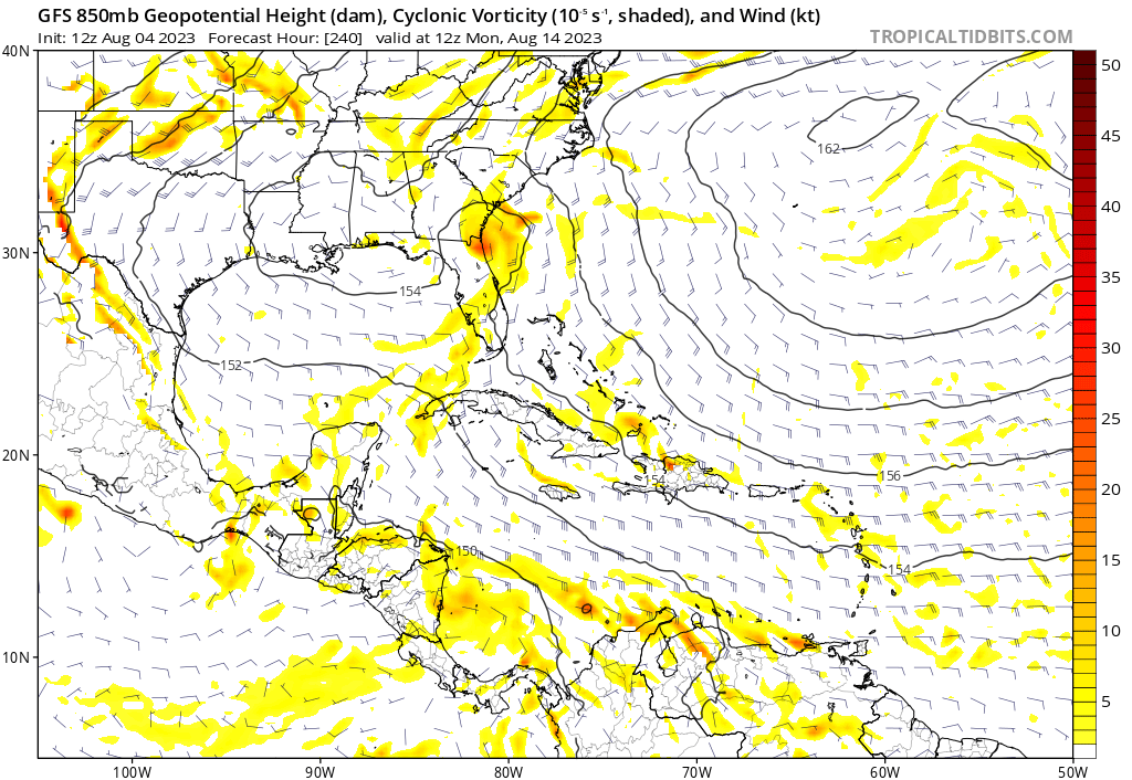
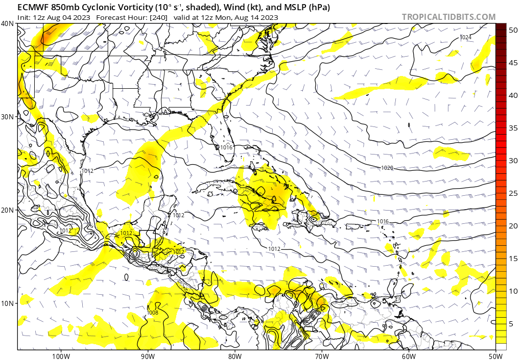
As for the models, it looks fairly normal out there in the MDR for early August. Still some dust to deal with, and the shear is a bit high for development. We should see a change in the next couple of weeks. Big question remaining is how will the El Nino affect the Caribbean? I still think those of you in the NE Caribbean, like Luis, may be in for a significant impact this season. Watch out Bahamas, South Florida, and the Carolinas.
15 likes   

LarryWx
S2K Supporter
S2K Supporter
Posts: 6305
Joined: Sun Sep 07, 2003 2:04 pm
Location: GA

Re: 2023 Global Model Runs Discussion (Out thru day 16)

#693 Postby LarryWx » Fri Aug 04, 2023 9:19 am

tiger_deF wrote:I'm starting to think that the wave that the CMC has been insistent on developing is actually the current wave off of the coast Africa (or an amalgamation of energies which is primarily driven by that wave). While the wave at 34W has been impressive convectively and has had a vigorous MLC, the vorticity at different levels of the atmosphere has not been stacked at all, and all signatures have been and currently are well to the East of the MLC. In addition, it's large pocket and sprawling characteristics make it easier for dry air to intrude on the system as the GFS suggests.

Meanwhile, the current wave off of Africa has 850-500mb vorticity in the same place and centered on it's convective mass, and a significantly more impressive (i.e. existing) surface 850mb presentation than the westward wave had at the same longitude. Development chances are still slim without model support, but it bears watching.


The last several days of the admittedly inferior quality CFS have been taking energy coming off Africa about now and having it early next week collide with energy now WSW of the CV Islands. It subsequently has TCG in the MDR. The TC ends up threatening the SE US at midmonth. On these CFS runs, that has been the most threatening system for the entire month to the SE US. But again, the CFS is relatively inferior. So, this is fwiw, which may not be much. But it does have the last few CMC/GEPS in pretty good agreement along with the ICON to an extent. Also, add the JMA to that support list.
0 likes   
Personal Forecast Disclaimer:
The posts in this forum are NOT official forecasts and should not be used as such. They are just the opinion of the poster and may or may not be backed by sound meteorological data. They are NOT endorsed by any professional institution or storm2k.org. For official information, please refer to the NHC and NWS products.

BobHarlem
Category 5
Category 5
Posts: 2105
Joined: Thu Oct 20, 2005 6:11 pm

Re: 2023 Global Model Runs Discussion (Out thru day 16)

#694 Postby BobHarlem » Fri Aug 04, 2023 11:36 am

12z Canadian is weaker this run with the wave just off Africa, doesn't develop like 0z does. However the vorticity area winds up in the Bahamas and near Florida around Aug 13-14 which matches fairly close to what the 12z gfs (and 12z euro) does with it. Anything that could potentially get over or near the Bahamas and Florida probably should be watched, even if it doesn't look like much now.
1 likes   

BobHarlem
Category 5
Category 5
Posts: 2105
Joined: Thu Oct 20, 2005 6:11 pm

Re: 2023 Global Model Runs Discussion (Out thru day 16)

#695 Postby BobHarlem » Fri Aug 04, 2023 2:08 pm

The other hint in the CMC/GFS/Euro (12z euro really made me notice it) is the weather currently over New England and parts of Canada getting out, spitting off then heading back west. Euro seems to be more organized than others, but between that trough and the wave I think there are signs things will change next week. It's just getting into the time of year where I'm a lot more suspicious of things than in July.
1 likes   

User avatar
gatorcane
S2K Supporter
S2K Supporter
Posts: 23691
Age: 47
Joined: Sun Mar 13, 2005 3:54 pm
Location: Boca Raton, FL

Re: 2023 Global Model Runs Discussion (Out thru day 16)

#696 Postby gatorcane » Fri Aug 04, 2023 2:22 pm

Both the GFS and the Euro show some kind of low-level vorticity heading west under a ridge. Euro into Cuba and GFS recurves over or near Florida. Who knows, the models could be underdoing the intensity as we know they are not that reliable this far out plus it is somewhat more defined on the 12Z Euro as compared to the 00Z:

GFS:
Image

Euro:
Image
1 likes   

hurricane2025
Tropical Storm
Tropical Storm
Posts: 208
Joined: Thu Apr 08, 2021 10:36 am

Re: 2023 Global Model Runs Discussion (Out thru day 16)

#697 Postby hurricane2025 » Fri Aug 04, 2023 3:02 pm

EURO ensembles lights up the gulf
0 likes   

User avatar
SFLcane
S2K Supporter
S2K Supporter
Posts: 10163
Age: 47
Joined: Sat Jun 05, 2010 1:44 pm
Location: Lake Worth Florida

Re: 2023 Global Model Runs Discussion (Out thru day 16)

#698 Postby SFLcane » Fri Aug 04, 2023 3:50 pm

This needs to be watched… :eek: 1/2 punch for Florida

Image
0 likes   

User avatar
Nimbus
Category 5
Category 5
Posts: 5300
Joined: Mon Jul 19, 2004 10:54 am

Re: 2023 Global Model Runs Discussion (Out thru day 16)

#699 Postby Nimbus » Fri Aug 04, 2023 4:09 pm

SFLcane wrote:This needs to be watched… :eek: 1/2 punch for Florida

https://i.postimg.cc/4N4sk9TZ/IMG-7385.gif


Big spread coming into the windward and leeward islands Wednesday-Thursday next week.
The most southern tracks are usually for weaker systems which have a lower chance of recurving into Florida.
0 likes   

Ianswfl
Category 1
Category 1
Posts: 482
Joined: Thu Mar 23, 2023 11:11 pm

Re: 2023 Global Model Runs Discussion (Out thru day 16)

#700 Postby Ianswfl » Fri Aug 04, 2023 4:20 pm

SFLcane wrote:This needs to be watched… :eek: 1/2 punch for Florida

https://i.postimg.cc/4N4sk9TZ/IMG-7385.gif


This thing is hauling speed under a high too towards the end of the run! Doesn't that remind you of a certain A storm? :eek: Models likely way underestimating the intensity here if there is low shear. I live in SWFL so I would get a weaker storm and little surge. I admit I'm kinda pumped up here in Punta Gorda because I love hurricanes.
0 likes   


Return to “Talkin' Tropics”

Who is online

Users browsing this forum: caneman and 48 guests