WPAC: DORA - Post-Tropical - Discussion

Moderator: S2k Moderators

Message
Author
Astromanía
Category 2
Category 2
Posts: 779
Age: 26
Joined: Sat Aug 25, 2018 10:34 pm
Location: Monterrey, N.L, México

Re: EPAC: DORA - Hurricane - Discussion

#261 Postby Astromanía » Sat Aug 05, 2023 2:49 pm

Yellow Evan wrote:GFS and ECMWF greatly diverge on shear after today, with the GFS showing strong westerly mid-level shear that would cap its intensity in the 70-90 knot range until it enters the WPAC. ECMWF has faster ML flow and slower trades which would lead to a lower shear vector but has not handled Dora well so far at all.

Considering how difficult is to predict shear, the poor job from models with this system since it's birth and how it is doing so far after all I think is better for us to just apreciate what this system can bring to us at time goes, I personally think it can still impress us way more
0 likes   

Sciencerocks
Category 5
Category 5
Posts: 9155
Age: 39
Joined: Thu Jul 06, 2017 1:51 am

Re: EPAC: DORA - Hurricane - Discussion

#262 Postby Sciencerocks » Sat Aug 05, 2023 2:57 pm

1 likes   

User avatar
Yellow Evan
Professional-Met
Professional-Met
Posts: 16143
Age: 27
Joined: Fri Jul 15, 2011 12:48 pm
Location: Henderson, Nevada/Honolulu, HI
Contact:

Re: EPAC: DORA - Hurricane - Discussion

#263 Postby Yellow Evan » Sat Aug 05, 2023 3:01 pm

Image

Eye slowly clearing though still not circular on IR so not fully cleared yet.
0 likes   

User avatar
Ntxw
Storm2k Moderator
Storm2k Moderator
Posts: 22784
Joined: Wed Oct 21, 2009 6:34 pm
Location: DFW, Texas

Re: EPAC: DORA - Hurricane - Discussion

#264 Postby Ntxw » Sat Aug 05, 2023 3:08 pm

A more traditional eye has been taking shape. Should it clear all the way, maybe 130kts?
0 likes   
The above post and any post by Ntxw is NOT an official forecast and should not be used as such. It is just the opinion of the poster and may or may not be backed by sound meteorological data. It is NOT endorsed by any professional institution including Storm2k. For official information, please refer to NWS products.

  Help support Storm2K!
Help Support Storm2K

User avatar
aspen
Category 5
Category 5
Posts: 8818
Joined: Sat Oct 12, 2019 7:10 pm
Location: Connecticut, USA

Re: EPAC: DORA - Hurricane - Discussion

#265 Postby aspen » Sat Aug 05, 2023 3:29 pm

Dora’s one awfully persistent storm. I thought shear would cause gradual weakening or at least keep it steady. Looks like it’ll be one of those likely 130 kt hurricanes that gets assessed as a 115-120 kt C4 due to Dvorak limitations (Douglas, Darby, etc).
0 likes   
Irene '11 Sandy '12 Hermine '16 5/15/2018 Derecho Fay '20 Isaias '20 Elsa '21 Henri '21 Ida '21

I am only a meteorology enthusiast who knows a decent amount about tropical cyclones. Look to the professional mets, the NHC, or your local weather office for the best information.

User avatar
Hurricane2022
Category 5
Category 5
Posts: 1541
Joined: Tue Aug 23, 2022 11:38 pm
Location: Araçatuba, Brazil

Re: EPAC: DORA - Hurricane - Discussion

#266 Postby Hurricane2022 » Sat Aug 05, 2023 3:29 pm

Image
1 likes   
Sorry for the bad English sometimes...!
For reliable and detailed information for any meteorological phenomenon, please consult the National Hurricane Center, Joint Typhoon Warning Center , or your local Meteo Center.

--------

Una cvm Christo, pro Christo, et in Christo. Sit nomen Domini benedictvm.

User avatar
Yellow Evan
Professional-Met
Professional-Met
Posts: 16143
Age: 27
Joined: Fri Jul 15, 2011 12:48 pm
Location: Henderson, Nevada/Honolulu, HI
Contact:

Re: EPAC: DORA - Hurricane - Discussion

#267 Postby Yellow Evan » Sat Aug 05, 2023 3:52 pm

Eye has reached WMG now. Good chance of an official 125 knot peak.
0 likes   

User avatar
Ntxw
Storm2k Moderator
Storm2k Moderator
Posts: 22784
Joined: Wed Oct 21, 2009 6:34 pm
Location: DFW, Texas

Re: EPAC: DORA - Hurricane - Discussion

#268 Postby Ntxw » Sat Aug 05, 2023 3:55 pm

Gorgeous.

Image

130W-150W has been the area we've been asking if a TC can survive with the cooler, less favorable preconditions. The answer so far for this is yes.
4 likes   
The above post and any post by Ntxw is NOT an official forecast and should not be used as such. It is just the opinion of the poster and may or may not be backed by sound meteorological data. It is NOT endorsed by any professional institution including Storm2k. For official information, please refer to NWS products.


  Help support Storm2K!

Help Support Storm2K


User avatar
Ntxw
Storm2k Moderator
Storm2k Moderator
Posts: 22784
Joined: Wed Oct 21, 2009 6:34 pm
Location: DFW, Texas

Re: EPAC: DORA - Hurricane - Discussion

#269 Postby Ntxw » Sat Aug 05, 2023 4:28 pm

Wow. No way this is less than 125kts.+16C eye.

Image
1 likes   
The above post and any post by Ntxw is NOT an official forecast and should not be used as such. It is just the opinion of the poster and may or may not be backed by sound meteorological data. It is NOT endorsed by any professional institution including Storm2k. For official information, please refer to NWS products.


  Help support Storm2K!

Help Support Storm2K


User avatar
cycloneye
Admin
Admin
Posts: 145300
Age: 68
Joined: Thu Oct 10, 2002 10:54 am
Location: San Juan, Puerto Rico

Re: EPAC: DORA - Hurricane - Discussion

#270 Postby cycloneye » Sat Aug 05, 2023 4:44 pm


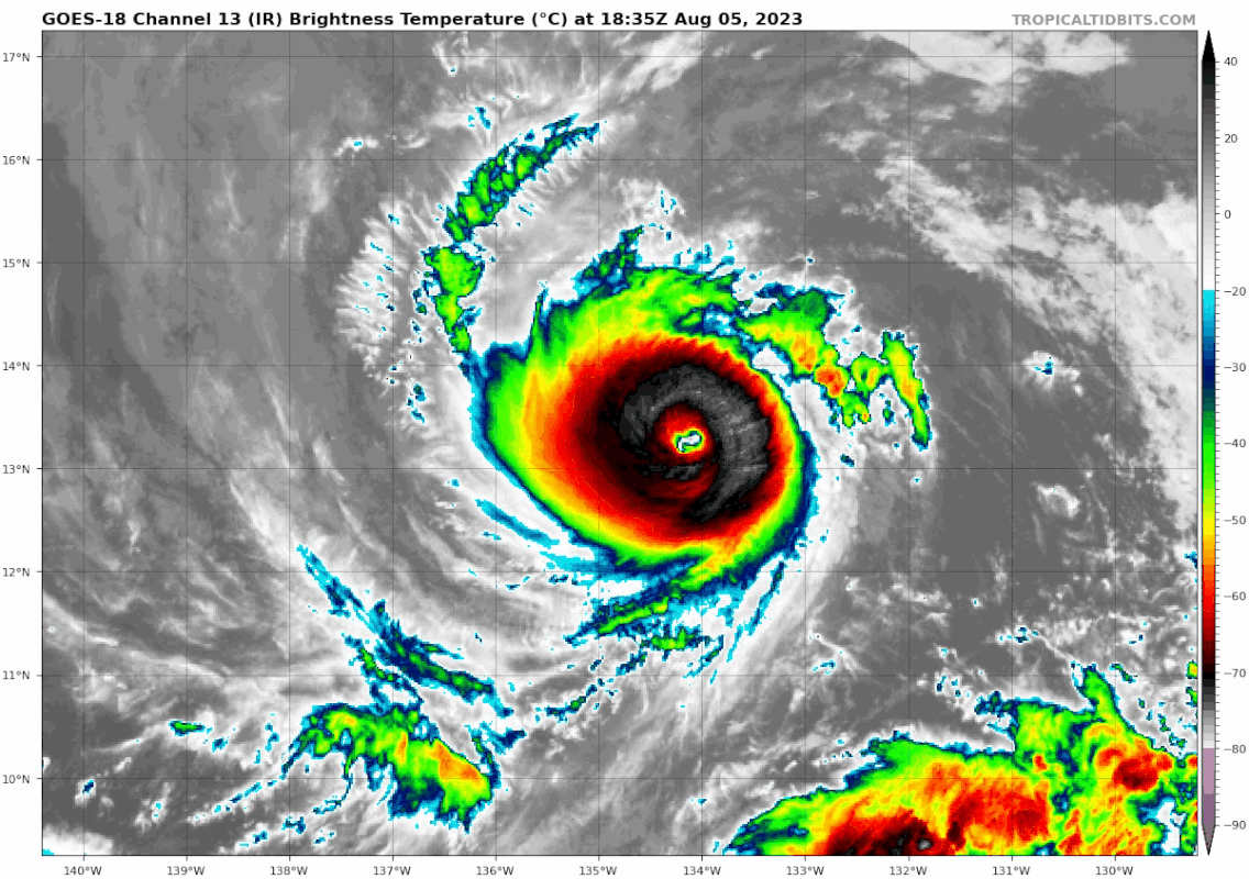
Hurricane Dora Discussion Number 22
NWS National Hurricane Center Miami FL EP052023
1100 AM HST Sat Aug 05 2023

Dora has become significantly better organized over the past six
hours, with a well-defined 15 n mi wide eye inside a cold central
dense overcast. The various subjective and objective satellite
intensity estimates are now in the 100-120 kt range, and the
initial intensity is increased to 115 kt in best agreement with the
subjective estimates from TAFB and SAB.

As noted in the last several advisories, Dora continues moving
westward along the southern side of a deep-layer ridge to the north.
This ridge is expected to build westward for the next three days
or so, which should induce a somewhat faster forward speed while it
passes well south of Hawaii early next week. There has been little
change to the track guidance since the last advisory, and the new
forecast track is again almost identical to the old track.

Dora is moving over sea surface temperatures near 27C, and it is
currently in a light-shear environment. This is at least partly
responsible for the current intensification. The intensity
guidance suggests this round of intensification should be almost
over, although there is some uncertainty in this since it
underestimated how strong the storm would get today. Based on the
current trends and the current guidance, the intensity forecast
calls for some additional strengthening during the next 12 h,
followed by some weakening. After 48 h, while Dora should remain
over 27C sea surface temperatures and in light shear through 96 h,
it is expected to encounter a drier environment and an area of
upper-level convergence. These factors should lead to continued
gradual weakening, with the caveat that there is a large spread in
the guidance on how much weakening will occur. The early part of
the intensity forecast follows the upper edge of the intensity
guidance, while the 60-120 h portion is in best agreement with the
SHIPS model.


FORECAST POSITIONS AND MAX WINDS

INIT 05/2100Z 13.3N 134.8W 115 KT 130 MPH
12H 06/0600Z 13.1N 137.3W 120 KT 140 MPH
24H 06/1800Z 12.9N 140.9W 110 KT 125 MPH
36H 07/0600Z 12.7N 144.6W 100 KT 115 MPH
48H 07/1800Z 12.5N 148.3W 90 KT 105 MPH
60H 08/0600Z 12.4N 152.2W 85 KT 100 MPH
72H 08/1800Z 12.3N 156.2W 80 KT 90 MPH
96H 09/1800Z 12.5N 164.0W 70 KT 80 MPH
120H 10/1800Z 13.5N 171.5W 65 KT 75 MPH

$$
Forecaster Beven
0 likes   
Visit the Caribbean-Central America Weather Thread where you can find at first post web cams,radars
and observations from Caribbean basin members Click Here

User avatar
Ptarmigan
Category 5
Category 5
Posts: 5313
Joined: Wed Aug 16, 2006 9:06 pm

Re: EPAC: DORA - Hurricane - Discussion

#271 Postby Ptarmigan » Sat Aug 05, 2023 5:30 pm

Impressive hurricane. Hurricane Dora is quite small. East Pacific hurricanes are generally smaller than Atlantic hurricanes due to being a smaller basin area.
0 likes   

User avatar
Yellow Evan
Professional-Met
Professional-Met
Posts: 16143
Age: 27
Joined: Fri Jul 15, 2011 12:48 pm
Location: Henderson, Nevada/Honolulu, HI
Contact:

Re: EPAC: DORA - Hurricane - Discussion

#272 Postby Yellow Evan » Sat Aug 05, 2023 5:31 pm

Image

Image
5 likes   

User avatar
Yellow Evan
Professional-Met
Professional-Met
Posts: 16143
Age: 27
Joined: Fri Jul 15, 2011 12:48 pm
Location: Henderson, Nevada/Honolulu, HI
Contact:

Re: EPAC: DORA - Hurricane - Discussion

#273 Postby Yellow Evan » Sat Aug 05, 2023 5:36 pm

Image

Image

Near T7.0. W needs to be fully wrapped around the eye at least half a degree to qualify for such.
1 likes   

Sciencerocks
Category 5
Category 5
Posts: 9155
Age: 39
Joined: Thu Jul 06, 2017 1:51 am

Re: EPAC: DORA - Hurricane - Discussion

#274 Postby Sciencerocks » Sat Aug 05, 2023 6:05 pm

Looks to be a pulling a isabel. I wouldn't be shocked if this becomes 145-150 knots during the next 6-12 hours.

Image
3 likes   

User avatar
Yellow Evan
Professional-Met
Professional-Met
Posts: 16143
Age: 27
Joined: Fri Jul 15, 2011 12:48 pm
Location: Henderson, Nevada/Honolulu, HI
Contact:

Re: EPAC: DORA - Hurricane - Discussion

#275 Postby Yellow Evan » Sat Aug 05, 2023 6:27 pm

Image

On the cusp of T7.0.
0 likes   

User avatar
Yellow Evan
Professional-Met
Professional-Met
Posts: 16143
Age: 27
Joined: Fri Jul 15, 2011 12:48 pm
Location: Henderson, Nevada/Honolulu, HI
Contact:

Re: EPAC: DORA - Hurricane - Discussion

#276 Postby Yellow Evan » Sat Aug 05, 2023 6:29 pm

----- Current Analysis -----
Date : 05 AUG 2023 Time : 224020 UTC
Lat : 13:16:12 N Lon : 135:15:35 W


CI# /Pressure/ Vmax
6.3 / 942.5mb/122.2kt


Final T# Adj T# Raw T#
6.3 6.5 6.5

Estimated radius of max. wind based on IR : 17 km

Center Temp : +12.9C Cloud Region Temp : -69.4C

Scene Type : EYE

Subtropical Adjustment : OFF

Extratropical Adjustment : OFF

Positioning Method : ARCHER POSITIONING
0 likes   

User avatar
Ntxw
Storm2k Moderator
Storm2k Moderator
Posts: 22784
Joined: Wed Oct 21, 2009 6:34 pm
Location: DFW, Texas

Re: EPAC: DORA - Hurricane - Discussion

#277 Postby Ntxw » Sat Aug 05, 2023 6:31 pm

Sciencerocks wrote:Looks to be a pulling a isabel. I wouldn't be shocked if this becomes 145-150 knots during the next 6-12 hours.

https://imagizer.imageshack.com/img923/637/OVZZPL.gif


Image

https://journals.ametsoc.org/view/journals/mwre/136/6/2007mwr1858.1.xml


Image

Dora is a very clean W ring, for a western hemisphere system.
2 likes   
The above post and any post by Ntxw is NOT an official forecast and should not be used as such. It is just the opinion of the poster and may or may not be backed by sound meteorological data. It is NOT endorsed by any professional institution including Storm2k. For official information, please refer to NWS products.


  Help support Storm2K!

Help Support Storm2K


User avatar
Teban54
Category 5
Category 5
Posts: 3204
Joined: Sat May 19, 2018 1:19 pm

Re: EPAC: DORA - Hurricane - Discussion

#278 Postby Teban54 » Sat Aug 05, 2023 6:37 pm

Impressive.

Especially for a time when weakening was expected.
Image
4 likes   

User avatar
Yellow Evan
Professional-Met
Professional-Met
Posts: 16143
Age: 27
Joined: Fri Jul 15, 2011 12:48 pm
Location: Henderson, Nevada/Honolulu, HI
Contact:

Re: EPAC: DORA - Hurricane - Discussion

#279 Postby Yellow Evan » Sat Aug 05, 2023 7:14 pm

Image

Barely short a T7.0.
2 likes   

User avatar
DorkyMcDorkface
Category 3
Category 3
Posts: 888
Age: 27
Joined: Mon Sep 30, 2019 1:32 pm
Location: Mid-Atlantic

Re: EPAC: DORA - Hurricane - Discussion

#280 Postby DorkyMcDorkface » Sat Aug 05, 2023 7:27 pm

What a spectacular little storm! Seems like the EPAC is always good for a storm or two of this type per season.
0 likes   
Please note the thougths expressed by this account are solely those of the user and are from a hobbyist perspective. For more comprehensive analysis, consult an actual professional meteorologist or meteorology agency.


Floyd 1999 | Isabel 2003 | Hanna 2008 | Irene 2011 | Sandy 2012 | Isaias 2020


Return to “2023”

Who is online

Users browsing this forum: No registered users and 3 guests