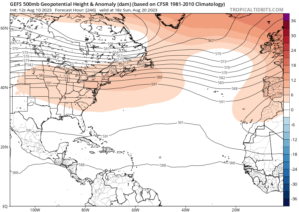
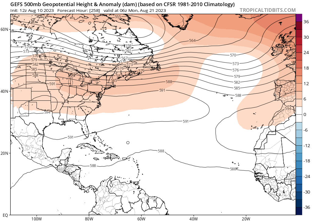
2023 Global Model Runs Discussion (Out thru day 16)

This is the general tropical discussion area. Anyone can take their shot at predicting a storms path.

Moderator: S2k Moderators

Forum rules

The posts in this forum are NOT official forecasts and should not be used as such. They are just the opinion of the poster and may or may not be backed by sound meteorological data. They are NOT endorsed by any professional institution or STORM2K. For official information, please refer to products from the National Hurricane Center and National Weather Service.

Help Support Storm2K
Message
Author
LarryWx
S2K Supporter
S2K Supporter
Posts: 6305
Joined: Sun Sep 07, 2003 2:04 pm
Location: GA

Re: 2023 Global Model Runs Discussion (Out thru day 16)

#801 Postby LarryWx » Thu Aug 10, 2023 8:52 am

SFLcane wrote:
LarryWx wrote:The various ensembles are suggesting E US ridging 8/21-4 followed by a hint of a trough moving in 8/25-6. That period as is often the case may be a risky one for the CONUS.


Can you post?


I have nothing specific to post or link to, but based on a general assessment of the 3 main ensembles by looking at the mean H5 along with the individual members.
0 likes   
Personal Forecast Disclaimer:
The posts in this forum are NOT official forecasts and should not be used as such. They are just the opinion of the poster and may or may not be backed by sound meteorological data. They are NOT endorsed by any professional institution or storm2k.org. For official information, please refer to the NHC and NWS products.

HoustonFrog
Tropical Depression
Tropical Depression
Posts: 98
Joined: Thu Jun 04, 2020 1:49 pm

Re: 2023 Global Model Runs Discussion (Out thru day 16)

#802 Postby HoustonFrog » Thu Aug 10, 2023 9:30 am

Tailgater33 wrote:As some of the models are suggesting I’m Hoping the little disturbed area entering the SE Bahamas/Eastern Cuba can bring a little pocket of moisture to south Louisiana or S/E Texas for some much needed rain, I’d take some heavy clouds at this point.


Yeah I'd take virtually anything but 100+, high humidity, no clouds here in Houston. Brutal summer.
1 likes   

User avatar
wxman57
Moderator-Pro Met
Moderator-Pro Met
Posts: 22978
Age: 67
Joined: Sat Jun 21, 2003 8:06 pm
Location: Houston, TX (southwest)

Re: 2023 Global Model Runs Discussion (Out thru day 16)

#803 Postby wxman57 » Thu Aug 10, 2023 9:59 am

HoustonFrog wrote:
Tailgater33 wrote:As some of the models are suggesting I’m Hoping the little disturbed area entering the SE Bahamas/Eastern Cuba can bring a little pocket of moisture to south Louisiana or S/E Texas for some much needed rain, I’d take some heavy clouds at this point.


Yeah I'd take virtually anything but 100+, high humidity, no clouds here in Houston. Brutal summer.


The heat isn't so bad, but the lack of rain isn't helping my lawn. Here in SW Houston, I've measured about 2 inches of rain since early June. Zero rain at all since July 7th. At least we have a few clouds around, not like back in 1980. Not as dry as 2011, either, where I had measured only 5 inches of rain between early January and August 10th. I miss seeing towering cumulus and thunderstorm activity across the city. Tried watering my lawn for 3 hours yesterday morning but it's still crispy today.
5 likes   

User avatar
MississippiWx
S2K Supporter
S2K Supporter
Posts: 1699
Joined: Sat Aug 14, 2010 1:44 pm
Location: Hattiesburg, Mississippi

Re: 2023 Global Model Runs Discussion (Out thru day 16)

#804 Postby MississippiWx » Thu Aug 10, 2023 10:25 am

The area just east of the Bahamas has my interest. There have been some ensemble members toying around with it developing as it heads to the Gulf. It's the only game in town and has an interesting look, so might be worth watching the next few days.
2 likes   
This post is not an official forecast and should not be used as such. It is just the opinion of MississippiWx and may or may not be backed by sound meteorological data. It is not endorsed by any professional institution including storm2k.org. For Official Information please refer to the NHC and NWS products.

HoustonFrog
Tropical Depression
Tropical Depression
Posts: 98
Joined: Thu Jun 04, 2020 1:49 pm

Re: 2023 Global Model Runs Discussion (Out thru day 16)

#805 Postby HoustonFrog » Thu Aug 10, 2023 10:25 am

wxman57 wrote:
HoustonFrog wrote:
Tailgater33 wrote:As some of the models are suggesting I’m Hoping the little disturbed area entering the SE Bahamas/Eastern Cuba can bring a little pocket of moisture to south Louisiana or S/E Texas for some much needed rain, I’d take some heavy clouds at this point.


Yeah I'd take virtually anything but 100+, high humidity, no clouds here in Houston. Brutal summer.


The heat isn't so bad, but the lack of rain isn't helping my lawn. Here in SW Houston, I've measured about 2 inches of rain since early June. Zero rain at all since July 7th. At least we have a few clouds around, not like back in 1980. Not as dry as 2011, either, where I had measured only 5 inches of rain between early January and August 10th. I miss seeing towering cumulus and thunderstorm activity across the city. Tried watering my lawn for 3 hours yesterday morning but it's still crispy today.


I'm north side, and yeh zero rain since early July/late June. We've at least picked up some wind past few days.... clouds are mostly non existent up here it seems. Maybe a little more than two weeks ago.

My daily read of SCW is painful
0 likes   

User avatar
Spacecoast
Category 2
Category 2
Posts: 758
Joined: Thu Aug 31, 2017 2:03 pm

Re: 2023 Global Model Runs Discussion (Out thru day 16)

#806 Postby Spacecoast » Thu Aug 10, 2023 10:44 am

MississippiWx wrote:The area just east of the Bahamas has my interest. There have been some ensemble members toying around with it developing as it heads to the Gulf. It's the only game in town and has an interesting look, so might be worth watching the next few days.

0z EPS shows ~35% probability of depression in 3-4 days.
Image
6z Euro also has vort heading into gulf in 2-3 days
Image
1 likes   

User avatar
SouthFLTropics
Category 5
Category 5
Posts: 4236
Age: 50
Joined: Thu Aug 14, 2003 8:04 am
Location: Port St. Lucie, Florida

Re: 2023 Global Model Runs Discussion (Out thru day 16)

#807 Postby SouthFLTropics » Thu Aug 10, 2023 12:18 pm

The recent GFS runs are throwing me for a loop. Typically, it is the GFS that is blowing up a monster storm and the rest of the models are quiet. Right now, it is opposite. The rest of the models are making some noise and the GFS is quiet. Does the same old adage stick? When the GFS is alone, don't trust it? I think I'd have to side with the odds and favor the remaining models, no matter what they say. It's almost like the GFS always wants to go against the rest of the class.
4 likes   
Fourth Generation Florida Native

Personal Storm History: David 79, Andrew 92, Erin 95, Floyd 99, Irene 99, Frances 04, Jeanne 04, Wilma 05, Matthew 16, Irma 17, Ian 22, Nicole 22, Milton 24

User avatar
SFLcane
S2K Supporter
S2K Supporter
Posts: 10163
Age: 47
Joined: Sat Jun 05, 2010 1:44 pm
Location: Lake Worth Florida

Re: 2023 Global Model Runs Discussion (Out thru day 16)

#808 Postby SFLcane » Thu Aug 10, 2023 12:38 pm

LarryWx wrote:
SFLcane wrote:
LarryWx wrote:The various ensembles are suggesting E US ridging 8/21-4 followed by a hint of a trough moving in 8/25-6. That period as is often the case may be a risky one for the CONUS.


Can you post?


I have nothing specific to post or link to, but based on a general assessment of the 3 main ensembles by looking at the mean H5 along with the individual members.


If there something out there if it misses first chance to turn its coming west.

Image

Image
Last edited by SFLcane on Thu Aug 10, 2023 12:42 pm, edited 1 time in total.
1 likes   

User avatar
cycloneye
Admin
Admin
Posts: 145301
Age: 68
Joined: Thu Oct 10, 2002 10:54 am
Location: San Juan, Puerto Rico

Re: 2023 Global Model Runs Discussion (Out thru day 16)

#809 Postby cycloneye » Thu Aug 10, 2023 12:40 pm

0 likes   
Visit the Caribbean-Central America Weather Thread where you can find at first post web cams,radars
and observations from Caribbean basin members Click Here

User avatar
Jr0d
S2K Supporter
S2K Supporter
Posts: 1409
Joined: Tue Aug 27, 2019 10:52 am
Location: Cayo Hueso

Re: 2023 Global Model Runs Discussion (Out thru day 16)

#810 Postby Jr0d » Thu Aug 10, 2023 12:43 pm

MississippiWx wrote:The area just east of the Bahamas has my interest. There have been some ensemble members toying around with it developing as it heads to the Gulf. It's the only game in town and has an interesting look, so might be worth watching the next few days.


I have been watching it also for a couple days. 2 nights ago it spit out a little vortex. While shower activity has waned it appears to have some spin.

The good thing is it will bring some much needed rain and relief for the heat here in the Keys.

It does seem like the models are deepening the convention a little before it approaches S. Florida. However the NHC is not interested in it so development is unlikely. Inam reminded of the low that FL developes.off central Florida about a month ago, that made landfall in N. Florida a brought some rain to Georgia and the Carolinas. It ended up getting a lemon and also had no model support. Had it had another day over water it very well may have been a storm.

This one has some slight model support, but the convective activity currently waxes and wanes instead of being sustained.
1 likes   

BobHarlem
Category 5
Category 5
Posts: 2105
Joined: Thu Oct 20, 2005 6:11 pm

Re: 2023 Global Model Runs Discussion (Out thru day 16)

#811 Postby BobHarlem » Thu Aug 10, 2023 2:06 pm

12z Canadian, 12z Icon, and 12z Euro both developing the wave in the MDR around Aug 18-20th. Nothing on the GFS. Euro turns it north, the other 2 (CMC/Icon) do not.
Last edited by BobHarlem on Thu Aug 10, 2023 2:08 pm, edited 2 times in total.
1 likes   

User avatar
SFLcane
S2K Supporter
S2K Supporter
Posts: 10163
Age: 47
Joined: Sat Jun 05, 2010 1:44 pm
Location: Lake Worth Florida

Re: 2023 Global Model Runs Discussion (Out thru day 16)

#812 Postby SFLcane » Thu Aug 10, 2023 2:07 pm

Afternoon Euro quickly turns these weak waves northward never making it past 40-50w. Meh
0 likes   

AutoPenalti
Category 5
Category 5
Posts: 4030
Age: 29
Joined: Mon Aug 17, 2015 4:16 pm
Location: Ft. Lauderdale, Florida

Re: 2023 Global Model Runs Discussion (Out thru day 16)

#813 Postby AutoPenalti » Thu Aug 10, 2023 2:10 pm

Euro 12z says "What Ridge?"
0 likes   
The posts in this forum are NOT official forecasts and should not be used as such. They are just the opinion of the poster and may or may not be backed by sound meteorological data. They are NOT endorsed by any professional institution or STORM2K. For official information, please refer to products from the NHC and NWS.


Model Runs Cheat Sheet:
GFS (5:30 AM/PM, 11:30 AM/PM)
HWRF, GFDL, UKMET, NAVGEM (6:30-8:00 AM/PM, 12:30-2:00 AM/PM)
ECMWF (1:45 AM/PM)

TCVN
is a weighted averaged

jlauderdal
S2K Supporter
S2K Supporter
Posts: 7182
Joined: Wed May 19, 2004 5:46 am
Location: NE Fort Lauderdale
Contact:

Re: 2023 Global Model Runs Discussion (Out thru day 16)

#814 Postby jlauderdal » Thu Aug 10, 2023 2:11 pm

SouthFLTropics wrote:The recent GFS runs are throwing me for a loop. Typically, it is the GFS that is blowing up a monster storm and the rest of the models are quiet. Right now, it is opposite. The rest of the models are making some noise and the GFS is quiet. Does the same old adage stick? When the GFS is alone, don't trust it? I think I'd have to side with the odds and favor the remaining models, no matter what they say. It's almost like the GFS always wants to go against the rest of the class.

There is no consistency at this point, we need to put a couple of days together where the models have the same general idea, it could start tomorrow or in two weeks, unknown at this point but the season cancel posts we had a few days ago disappeared in a hurry.
1 likes   

User avatar
cycloneye
Admin
Admin
Posts: 145301
Age: 68
Joined: Thu Oct 10, 2002 10:54 am
Location: San Juan, Puerto Rico

Re: 2023 Global Model Runs Discussion (Out thru day 16)

#815 Postby cycloneye » Thu Aug 10, 2023 2:12 pm

BobHarlem wrote:12z Canadian, 12z Icon, and 12z Euro both developing the wave in the MDR around Aug 18-20th. Nothing on the GFS. Euro turns it north, the other 2 (CMC/Icon) do not.


Big mixbag from them with no consensus on anything. Let's see if the next runs, they align better.
1 likes   
Visit the Caribbean-Central America Weather Thread where you can find at first post web cams,radars
and observations from Caribbean basin members Click Here

User avatar
SFLcane
S2K Supporter
S2K Supporter
Posts: 10163
Age: 47
Joined: Sat Jun 05, 2010 1:44 pm
Location: Lake Worth Florida

Re: 2023 Global Model Runs Discussion (Out thru day 16)

#816 Postby SFLcane » Thu Aug 10, 2023 2:14 pm

AutoPenalti wrote:Euro 12z says "What Ridge?"


I mean makes sense gonna be hard to get anything far west this year with +ENSO - lots of TUTT/westerlies. 1995
1 likes   

User avatar
Sambucol
Tropical Storm
Tropical Storm
Posts: 223
Joined: Wed Jul 25, 2007 5:09 pm

Re: 2023 Global Model Runs Discussion (Out thru day 16)

#817 Postby Sambucol » Thu Aug 10, 2023 2:28 pm

SFLcane wrote:
AutoPenalti wrote:Euro 12z says "What Ridge?"


I mean makes sense gonna be hard to get anything far west this year with +ENSO - lots of TUTT/westerlies. 1995

I hope you’re right!! We need rain in Texas, but we don’t need anything like a hurricane.
1 likes   

User avatar
Nimbus
Category 5
Category 5
Posts: 5300
Joined: Mon Jul 19, 2004 10:54 am

Re: 2023 Global Model Runs Discussion (Out thru day 16)

#818 Postby Nimbus » Thu Aug 10, 2023 2:40 pm

MississippiWx wrote:The area just east of the Bahamas has my interest. There have been some ensemble members toying around with it developing as it heads to the Gulf. It's the only game in town and has an interesting look, so might be worth watching the next few days.


That is headed to the gulf?
I saw the warm core signature with the semicircular circulation probably still at the mid levels.
Could be invest worthy but very dry air to its southwest inhibiting development ATM.
1 likes   

User avatar
Jr0d
S2K Supporter
S2K Supporter
Posts: 1409
Joined: Tue Aug 27, 2019 10:52 am
Location: Cayo Hueso

Re: 2023 Global Model Runs Discussion (Out thru day 16)

#819 Postby Jr0d » Thu Aug 10, 2023 2:48 pm

Spacecoast wrote:
MississippiWx wrote:The area just east of the Bahamas has my interest. There have been some ensemble members toying around with it developing as it heads to the Gulf. It's the only game in town and has an interesting look, so might be worth watching the next few days.

0z EPS shows ~35% probability of depression in 3-4 days.
https://i.ibb.co/GWR95g5/ef1.jpg
6z Euro also has vort heading into gulf in 2-3 days
https://i.ibb.co/7jVK2qk/ef2.jpg


There is weak low level spin around 23.2N 73W. It might be a good spot to for thunderstorms to fire later tonight during D-max. These nightly storms wane the next morning. Unless it can sustain convection (obviously) nothing significant will develop.

The CMC and Euro show a weak vort going over the Fl. Keys while the GFS splits it taking a vort north up the gulf stream toward CFL and another weak vort across the Keys and into the gulf. Perhaps if tonights (pending)convection persists all day tomorrow then we might get a lemon from the NHC tomorrow night, still doubtful of course.

Hopefully we get some rain and stormy weather this weekend to help cool the water and give us some relief (wide spread 90°+water all over the Keys and heat indexes hitting 119° currently), also the last two nights 7pm weather balloons showed CAPE values just over 3500, so plenty of fuel when the wave axis gets here.

At this point I would gladly take a depression or weak storm spinning up over us for the cooling effect however significant development of this feature is unlikely(but not impossible).
1 likes   

User avatar
SFLcane
S2K Supporter
S2K Supporter
Posts: 10163
Age: 47
Joined: Sat Jun 05, 2010 1:44 pm
Location: Lake Worth Florida

Re: 2023 Global Model Runs Discussion (Out thru day 16)

#820 Postby SFLcane » Thu Aug 10, 2023 2:56 pm

"Luis" please refrain from looking at the 12z EPS... :sick:

Image
0 likes   


Return to “Talkin' Tropics”

Who is online

Users browsing this forum: Google Adsense [Bot], SconnieCane and 27 guests