2023 Global Model Runs Discussion (Out thru day 16)

This is the general tropical discussion area. Anyone can take their shot at predicting a storms path.

Moderator: S2k Moderators

Forum rules

The posts in this forum are NOT official forecasts and should not be used as such. They are just the opinion of the poster and may or may not be backed by sound meteorological data. They are NOT endorsed by any professional institution or STORM2K. For official information, please refer to products from the National Hurricane Center and National Weather Service.

Help Support Storm2K
Message
Author
BobHarlem
Category 5
Category 5
Posts: 2105
Joined: Thu Oct 20, 2005 6:11 pm

Re: 2023 Global Model Runs Discussion (Out thru day 16)

#821 Postby BobHarlem » Thu Aug 10, 2023 3:12 pm

SFLcane wrote:"Luis" please refrain from looking at the 12z EPS... :sick:

https://i.postimg.cc/sXhdHD0P/EPS.png


Image
11 likes   

User avatar
cycloneye
Admin
Admin
Posts: 145301
Age: 68
Joined: Thu Oct 10, 2002 10:54 am
Location: San Juan, Puerto Rico

Re: 2023 Global Model Runs Discussion (Out thru day 16)

#822 Postby cycloneye » Thu Aug 10, 2023 3:50 pm

SFLcane wrote:"Luis" please refrain from looking at the 12z EPS... :sick:

https://i.postimg.cc/sXhdHD0P/EPS.png


Saw a bunch of L's. :sick:
0 likes   
Visit the Caribbean-Central America Weather Thread where you can find at first post web cams,radars
and observations from Caribbean basin members Click Here

User avatar
Jr0d
S2K Supporter
S2K Supporter
Posts: 1409
Joined: Tue Aug 27, 2019 10:52 am
Location: Cayo Hueso

Re: 2023 Global Model Runs Discussion (Out thru day 16)

#823 Postby Jr0d » Thu Aug 10, 2023 3:57 pm

BobHarlem wrote:
SFLcane wrote:"Luis" please refrain from looking at the 12z EPS... :sick:

https://i.postimg.cc/sXhdHD0P/EPS.png


https://i.imgur.com/QgE6804.jpg


10 more days until the bell!

The only thing even remotely interesting right now(besides fantasy land model outputs) is the tropical wave thats axis is now near East Cuba with some convection north of Hispaniola, the Turks and Caicos, eastern Cuba and the Southeast Bahamas.

While significant development is just above nil, there is some low level spin and will being much needed rain and heat relief to South Florida and the Keys. I figure it will get much more attention as is approaches Florida this weekend especially if that low level spin is visible on radar.
0 likes   

Wampadawg
Tropical Storm
Tropical Storm
Posts: 238
Joined: Wed Oct 14, 2020 10:28 am
Location: South Texas

Re: 2023 Global Model Runs Discussion (Out thru day 16)

#824 Postby Wampadawg » Thu Aug 10, 2023 4:26 pm

0 likes   
Harvey,Hanna,Beta,Texas Winter storm2021,Nicholas,Beryl

User avatar
wxman57
Moderator-Pro Met
Moderator-Pro Met
Posts: 22978
Age: 67
Joined: Sat Jun 21, 2003 8:06 pm
Location: Houston, TX (southwest)

Re: 2023 Global Model Runs Discussion (Out thru day 16)

#825 Postby wxman57 » Thu Aug 10, 2023 4:49 pm

Nimbus wrote:
MississippiWx wrote:The area just east of the Bahamas has my interest. There have been some ensemble members toying around with it developing as it heads to the Gulf. It's the only game in town and has an interesting look, so might be worth watching the next few days.


That is headed to the gulf?
I saw the warm core signature with the semicircular circulation probably still at the mid levels.
Could be invest worthy but very dry air to its southwest inhibiting development ATM.


Somewhere <1% chance of that area of thunderstorms near the Bahamas developing. May need to watch the eastern MDR for something to spin up next week. If it does, then the mid-Atlantic ridge looks like it'll be displaced east toward the Azores, allowing for an early recurve. Temp is 102F at my house in SW Houston. I don't mind the warm weather, but I want to see a thunderstorm.
5 likes   

BobHarlem
Category 5
Category 5
Posts: 2105
Joined: Thu Oct 20, 2005 6:11 pm

Re: 2023 Global Model Runs Discussion (Out thru day 16)

#826 Postby BobHarlem » Thu Aug 10, 2023 6:49 pm

MississippiWx wrote:The area just east of the Bahamas has my interest. There have been some ensemble members toying around with it developing as it heads to the Gulf. It's the only game in town and has an interesting look, so might be worth watching the next few days.


This is showing up on Bahamas radar https://radars.bahamasweather.org.bs/
1 likes   

User avatar
Spacecoast
Category 2
Category 2
Posts: 758
Joined: Thu Aug 31, 2017 2:03 pm

Re: 2023 Global Model Runs Discussion (Out thru day 16)

#827 Postby Spacecoast » Thu Aug 10, 2023 7:02 pm

12z EPS: ~15% Hurricane probability
Image
3 likes   


LarryWx
S2K Supporter
S2K Supporter
Posts: 6305
Joined: Sun Sep 07, 2003 2:04 pm
Location: GA

Re: 2023 Global Model Runs Discussion (Out thru day 16)

#829 Postby LarryWx » Fri Aug 11, 2023 12:21 am

Spacecoast wrote:12z EPS: ~15% Hurricane probability
https://i.ibb.co/LpnWZc5/ef3.jpg


This is consistent with counting 8 hurricanes out of the 51 members from this, which is about as active as any EPS run in quite awhile. I can trace this all the way back to the 0Z Aug 4th run. Also, I noticed that what the 12Z Euro developed and then recurved early is not the EPS wave leading to 15% Hs. Rather it is a wave to come off over this weekend, which is ahead of the wave that produces the aforementioned recurving 12Z Euro low. Yesterday's 0Z Euro actually showed the active EPS wave better. It has it just E of the LAs at the end with the recurver well out in the mid MDR then.

So, I'm saying the EPS has been harping on the wave to come off this weekend as opposed to one to come off a couple of days later.
0 likes   
Personal Forecast Disclaimer:
The posts in this forum are NOT official forecasts and should not be used as such. They are just the opinion of the poster and may or may not be backed by sound meteorological data. They are NOT endorsed by any professional institution or storm2k.org. For official information, please refer to the NHC and NWS products.

jconsor
Professional-Met
Professional-Met
Posts: 551
Joined: Mon Jun 30, 2008 9:31 pm
Location: Jerusalem, Israel
Contact:

Re: 2023 Global Model Runs Discussion (Out thru day 16)

#830 Postby jconsor » Fri Aug 11, 2023 1:57 am

Agreed. The Bahamas system has maintained healthy outflow aloft and some mid-level spin on satellite for at least 24 hours, though convection has waxed and waned.

I wrote about the potential for this system (or a few others trailing it) to take advantage of favorable light shear in the Gulf of Mexico next week and possibly become "surprise" TCs.

 https://twitter.com/yconsor/status/1689720713966469121


 https://twitter.com/yconsor/status/1689884090860740608


 https://twitter.com/yconsor/status/1689888114058129408


 https://twitter.com/yconsor/status/1689890971641610240


MississippiWx wrote:The area just east of the Bahamas has my interest. There have been some ensemble members toying around with it developing as it heads to the Gulf. It's the only game in town and has an interesting look, so might be worth watching the next few days.
4 likes   

LarryWx
S2K Supporter
S2K Supporter
Posts: 6305
Joined: Sun Sep 07, 2003 2:04 pm
Location: GA

Re: 2023 Global Model Runs Discussion (Out thru day 16)

#831 Postby LarryWx » Fri Aug 11, 2023 2:35 am

LarryWx wrote:
Spacecoast wrote:12z EPS: ~15% Hurricane probability
https://i.ibb.co/LpnWZc5/ef3.jpg


This is consistent with counting 8 hurricanes out of the 51 members from this, which is about as active as any EPS run in quite awhile. I can trace this all the way back to the 0Z Aug 4th run. Also, I noticed that what the 12Z Euro developed and then recurved early is not the EPS wave leading to 15% Hs. Rather it is a wave to come off over this weekend, which is ahead of the wave that produces the aforementioned recurving 12Z Euro low. Yesterday's 0Z Euro actually showed the active EPS wave better. It has it just E of the LAs at the end with the recurver well out in the mid MDR then.

So, I'm saying the EPS has been harping on the wave to come off this weekend as opposed to one to come off a couple of days later.


The new 0Z Euro has the active EPS system just S of PR as a strengthening 1005 low moving WNW at 240 and has very little for the followup wave that recurved on the 12Z.
2 likes   
Personal Forecast Disclaimer:
The posts in this forum are NOT official forecasts and should not be used as such. They are just the opinion of the poster and may or may not be backed by sound meteorological data. They are NOT endorsed by any professional institution or storm2k.org. For official information, please refer to the NHC and NWS products.

User avatar
Ivanhater
Storm2k Moderator
Storm2k Moderator
Posts: 11161
Age: 38
Joined: Fri Jul 01, 2005 8:25 am
Location: Pensacola

Re: 2023 Global Model Runs Discussion (Out thru day 16)

#832 Postby Ivanhater » Fri Aug 11, 2023 2:56 am

00Z Euro...that is certainly an alarming position for a strengthening storm in mid August

Image

Sent from my moto g stylus 5G (2022) using Tapatalk
0 likes   
Michael

User avatar
Yellow Evan
Professional-Met
Professional-Met
Posts: 16143
Age: 27
Joined: Fri Jul 15, 2011 12:48 pm
Location: Henderson, Nevada/Honolulu, HI
Contact:

Re: 2023 Global Model Runs Discussion (Out thru day 16)

#833 Postby Yellow Evan » Fri Aug 11, 2023 3:14 am

:uarrow: Look at how broad and unconsolidated the 850 hPa vortex is. Not sure if a system like that would be able to strengthen.
2 likes   

User avatar
Ivanhater
Storm2k Moderator
Storm2k Moderator
Posts: 11161
Age: 38
Joined: Fri Jul 01, 2005 8:25 am
Location: Pensacola

Re: 2023 Global Model Runs Discussion (Out thru day 16)

#834 Postby Ivanhater » Fri Aug 11, 2023 3:17 am

Yellow Evan wrote::uarrow: Look at how broad and unconsolidated the 850 hPa vortex is. Not sure if a system like that would be able to strengthen.


I suspect the Euro is being conservative like usual. Interesting to see it starting to wake up nonetheless.
4 likes   
Michael

User avatar
Teban54
Category 5
Category 5
Posts: 3204
Joined: Sat May 19, 2018 1:19 pm

Re: 2023 Global Model Runs Discussion (Out thru day 16)

#835 Postby Teban54 » Fri Aug 11, 2023 3:39 am

1 likes   

LarryWx
S2K Supporter
S2K Supporter
Posts: 6305
Joined: Sun Sep 07, 2003 2:04 pm
Location: GA

Re: 2023 Global Model Runs Discussion (Out thru day 16)

#836 Postby LarryWx » Fri Aug 11, 2023 3:51 am

Ivanhater wrote:
Yellow Evan wrote::uarrow: Look at how broad and unconsolidated the 850 hPa vortex is. Not sure if a system like that would be able to strengthen.


I suspect the Euro is being conservative like usual. Interesting to see it starting to wake up nonetheless.


Furthermore, the 0Z EPS is once again active with that wave, which may be the next one that bears watching.

Meanwhile, the 0Z GFS has a H south of LA on 8/26. That makes 5 GFS runs out of 45 (1 in 9) since 7/31 with a H on the run:

-7/31 12Z: hit SC 8/16
-8/3 6Z: hit MX/TX border 8/16
-8/6 0Z: MDR 8/18-21
-8/9 18Z: just off SC 8/25
-8/11 0Z: just off LA 8/26
2 likes   
Personal Forecast Disclaimer:
The posts in this forum are NOT official forecasts and should not be used as such. They are just the opinion of the poster and may or may not be backed by sound meteorological data. They are NOT endorsed by any professional institution or storm2k.org. For official information, please refer to the NHC and NWS products.

User avatar
kevin
Category 5
Category 5
Posts: 2586
Age: 26
Joined: Wed Aug 28, 2019 4:35 am

Re: 2023 Global Model Runs Discussion (Out thru day 16)

#837 Postby kevin » Fri Aug 11, 2023 4:28 am

This isn't something you see often, the euro ensemble is significantly more active than the gfs one. Or does the euro now have more members than the gfs?

Euro (+240)

Image

GFS (+240)

Image
0 likes   

User avatar
Teban54
Category 5
Category 5
Posts: 3204
Joined: Sat May 19, 2018 1:19 pm

Re: 2023 Global Model Runs Discussion (Out thru day 16)

#838 Postby Teban54 » Fri Aug 11, 2023 4:34 am

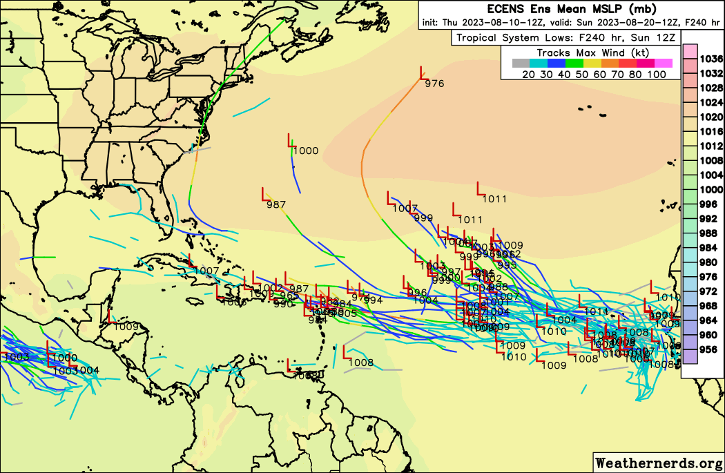
kevin wrote:This isn't something you see often, the euro ensemble is significantly more active than the gfs one. Or does the euro now have more members than the gfs?

Euro (+240)

https://i.imgur.com/7UDmURB.png

GFS (+240)

https://i.imgur.com/MSCqMDy.png

AFAIK, EPS has 51 members while GEFS has 31.

Regardless, Euro ensembles were often more enthusiastic with MDR development than GFS ensembles. This was the case for 95L and 96L, and IIRC a number of MDR waves last year.
1 likes   

User avatar
gatorcane
S2K Supporter
S2K Supporter
Posts: 23691
Age: 47
Joined: Sun Mar 13, 2005 3:54 pm
Location: Boca Raton, FL

Re: 2023 Global Model Runs Discussion (Out thru day 16)

#839 Postby gatorcane » Fri Aug 11, 2023 6:29 am

The GFS continues to insist that the favorable conditions will be over the EPAC and not the Atlantic over the next 10 days. The upper-level flow it is predicting does not look favorable for significant development across the MDR. Strong westerly flow across the Gulf, Florida, the SW Atlantic, and the Caribbean. Day 10 below:

Image
1 likes   

User avatar
Blown Away
S2K Supporter
S2K Supporter
Posts: 10145
Joined: Wed May 26, 2004 6:17 am

Re: 2023 Global Model Runs Discussion (Out thru day 16)

#840 Postby Blown Away » Fri Aug 11, 2023 6:45 am

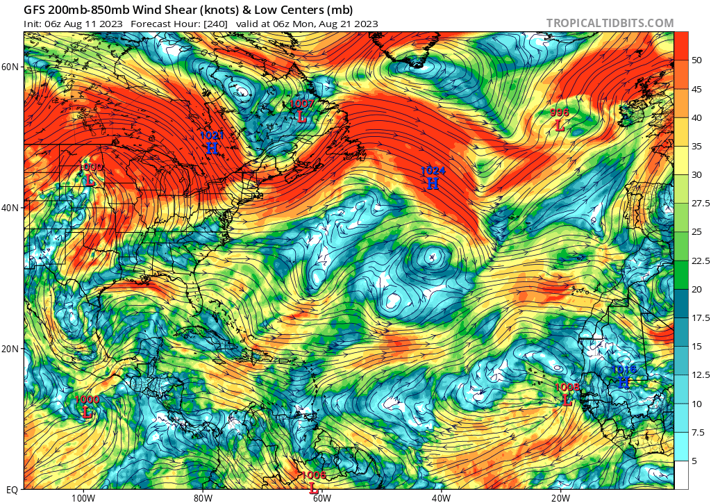
gatorcane wrote:The GFS continues to insist that the favorable conditions will be over the EPAC and not the Atlantic over the next 10 days. The upper-level flow it is predicting does not look favorable for significant development across the MDR. Strong westerly flow across the Gulf, Florida, the SW Atlantic, and the Caribbean. Day 10 below:

https://i.postimg.cc/mrqX9kXm/gfs-shear-atl-41.png


That SW flow over Florida has been persistent for months. Rain almost every afternoon in SFL (More than usual). Waiting for that pattern to break and get that nice HP flow off the Atlantic, that's my signal the hurricane season for SFL has started.
0 likes   
Hurricane Eye Experience: David 79, Irene 99, Frances 04, Jeanne 04, Wilma 05... EYE COMING MY WAY IN 2024…
Hurricane Brush Experience: Andrew 92, Erin 95, Floyd 99, Matthew 16, Irma 17, Ian 22, Nicole 22…


Return to “Talkin' Tropics”

Who is online

Users browsing this forum: Google Adsense [Bot], SconnieCane and 38 guests