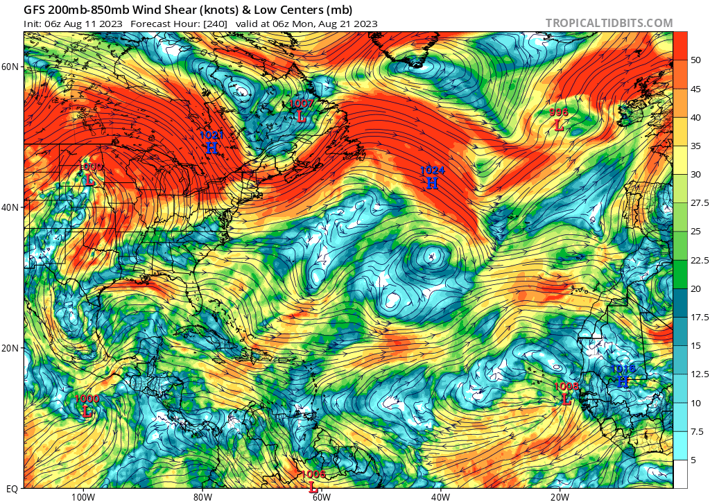
2023 Global Model Runs Discussion (Out thru day 16)

This is the general tropical discussion area. Anyone can take their shot at predicting a storms path.

Moderator: S2k Moderators

Forum rules

The posts in this forum are NOT official forecasts and should not be used as such. They are just the opinion of the poster and may or may not be backed by sound meteorological data. They are NOT endorsed by any professional institution or STORM2K. For official information, please refer to products from the National Hurricane Center and National Weather Service.

Help Support Storm2K
Message
Author
User avatar
SFLcane
S2K Supporter
S2K Supporter
Posts: 10163
Age: 47
Joined: Sat Jun 05, 2010 1:44 pm
Location: Lake Worth Florida

Re: 2023 Global Model Runs Discussion (Out thru day 16)

#841 Postby SFLcane » Fri Aug 11, 2023 8:17 am

gatorcane wrote:The GFS continues to insist that the favorable conditions will be over the EPAC and not the Atlantic over the next 10 days. The upper-level flow it is predicting does not look favorable for significant development across the MDR. Strong westerly flow across the Gulf, Florida, the SW Atlantic, and the Caribbean. Day 10 below:

https://i.postimg.cc/mrqX9kXm/gfs-shear-atl-41.png


Yup we get you so is the season cancelled or should we not prepare? Noaa raised the odds for a very busy season yesterday due to the coupling of the atmosphere which has not taken hold of the atlantic basin yet. I fully expect things will get very busy mid to late month.
1 likes   

User avatar
Blown Away
S2K Supporter
S2K Supporter
Posts: 10145
Joined: Wed May 26, 2004 6:17 am

Re: 2023 Global Model Runs Discussion (Out thru day 16)

#842 Postby Blown Away » Fri Aug 11, 2023 8:18 am

Image
Meanwhile, the GFS is closing in on September with very little consistent action in the Atlantic basin. EPAC just keeps rolling.
0 likes   
Hurricane Eye Experience: David 79, Irene 99, Frances 04, Jeanne 04, Wilma 05... EYE COMING MY WAY IN 2024…
Hurricane Brush Experience: Andrew 92, Erin 95, Floyd 99, Matthew 16, Irma 17, Ian 22, Nicole 22…

AutoPenalti
Category 5
Category 5
Posts: 4030
Age: 29
Joined: Mon Aug 17, 2015 4:16 pm
Location: Ft. Lauderdale, Florida

Re: 2023 Global Model Runs Discussion (Out thru day 16)

#843 Postby AutoPenalti » Fri Aug 11, 2023 8:23 am

I find it hard to believe NOAA would raise their forecasts and all of the sudden there's no development until September... that would be one helluva backloaded season.
3 likes   
The posts in this forum are NOT official forecasts and should not be used as such. They are just the opinion of the poster and may or may not be backed by sound meteorological data. They are NOT endorsed by any professional institution or STORM2K. For official information, please refer to products from the NHC and NWS.


Model Runs Cheat Sheet:
GFS (5:30 AM/PM, 11:30 AM/PM)
HWRF, GFDL, UKMET, NAVGEM (6:30-8:00 AM/PM, 12:30-2:00 AM/PM)
ECMWF (1:45 AM/PM)

TCVN
is a weighted averaged

User avatar
Teban54
Category 5
Category 5
Posts: 3204
Joined: Sat May 19, 2018 1:19 pm

Re: 2023 Global Model Runs Discussion (Out thru day 16)

#844 Postby Teban54 » Fri Aug 11, 2023 8:24 am

gatorcane wrote:The GFS continues to insist that the favorable conditions will be over the EPAC and not the Atlantic over the next 10 days. The upper-level flow it is predicting does not look favorable for significant development across the MDR. Strong westerly flow across the Gulf, Florida, the SW Atlantic, and the Caribbean. Day 10 below:

https://i.postimg.cc/mrqX9kXm/gfs-shear-atl-41.png

Question: If we always say GFS is on drugs whenever it's alone in showing favorable conditions and blowing up a model cane, why should we treat it as gospel when it's alone in showing unfavorable conditions and not developing systems that other models are at least showing hints of?
10 likes   

User avatar
jfk08c
S2K Supporter
S2K Supporter
Posts: 204
Joined: Mon Jun 11, 2018 4:36 pm
Location: Lakeland, FL

Re: 2023 Global Model Runs Discussion (Out thru day 16)

#845 Postby jfk08c » Fri Aug 11, 2023 8:45 am

Teban54 wrote:
gatorcane wrote:The GFS continues to insist that the favorable conditions will be over the EPAC and not the Atlantic over the next 10 days. The upper-level flow it is predicting does not look favorable for significant development across the MDR. Strong westerly flow across the Gulf, Florida, the SW Atlantic, and the Caribbean. Day 10 below:

https://i.postimg.cc/mrqX9kXm/gfs-shear-atl-41.png

Question: If we always say GFS is on drugs whenever it's alone in showing favorable conditions and blowing up a model cane, why should we treat it as gospel when it's alone in showing unfavorable conditions and not developing systems that other models are at least showing hints of?


How dare you bring logic into this!

But in all serious, I think some people have a hard time overcoming confirmation bias and will tend to judge models that support their theory more favorably than others. Just the way it goes. Especially when there is not an active storm to be observed, we have to look at something and try and draw a conclusion
Last edited by jfk08c on Fri Aug 11, 2023 8:48 am, edited 1 time in total.
2 likes   

jlauderdal
S2K Supporter
S2K Supporter
Posts: 7182
Joined: Wed May 19, 2004 5:46 am
Location: NE Fort Lauderdale
Contact:

Re: 2023 Global Model Runs Discussion (Out thru day 16)

#846 Postby jlauderdal » Fri Aug 11, 2023 8:46 am

AutoPenalti wrote:I find it hard to believe NOAA would raise their forecasts and all of the sudden there's no development until September... that would be one helluva backloaded season.

The models can have flipped in a day this deep into a hurricane season, tomorrow the 240 could show three systems, patience.
2 likes   

User avatar
Spacecoast
Category 2
Category 2
Posts: 758
Joined: Thu Aug 31, 2017 2:03 pm

Re: 2023 Global Model Runs Discussion (Out thru day 16)

#847 Postby Spacecoast » Fri Aug 11, 2023 8:46 am

Teban54 wrote:
gatorcane wrote:The GFS continues to insist that the favorable conditions will be over the EPAC and not the Atlantic over the next 10 days. The upper-level flow it is predicting does not look favorable for significant development across the MDR. Strong westerly flow across the Gulf, Florida, the SW Atlantic, and the Caribbean. Day 10 below:

https://i.postimg.cc/mrqX9kXm/gfs-shear-atl-41.png

Question: If we always say GFS is on drugs whenever it's alone in showing favorable conditions and blowing up a model cane, why should we treat it as gospel when it's alone in showing unfavorable conditions and not developing systems that other models are at least showing hints of?


We shouldn't treat any model as gospel. However, there is verification data available that describes success ratios, etc.
A high false positive rate, does not necessarily correlate to a high false negative rate. I have seen data indicating the GFS (in the past), had a significant false positive, but false negative verification data is difficult to find.

https://yaleclimateconnections.org/2023/06/which-hurricane-models-should-you-trust-in-2023/
<snip>
" The model with the highest success ratio (rewarding correct genesis forecasts combined with the fewest false alarms) was the European, followed by the UKMET, GFS, and Canadian models."
"The European model had the lowest probability of correctly making a genesis forecast – near 20% – but had the fewest false alarms. The GFS correctly made genesis forecasts 20 – 25% of the time but had more false alarms. The Canadian model had the best chance of making a correct genesis forecast but also had the highest number of false alarms. The take-home message: The Canadian model’s predicting genesis suggests something may be afoot, but don’t bet on it until the European model comes on board. In general, when two or more models make the same genesis forecast, the odds of the event actually occurring increase considerably."
Last edited by Spacecoast on Fri Aug 11, 2023 9:14 am, edited 1 time in total.
2 likes   

User avatar
cycloneye
Admin
Admin
Posts: 145303
Age: 68
Joined: Thu Oct 10, 2002 10:54 am
Location: San Juan, Puerto Rico

Re: 2023 Global Model Runs Discussion (Out thru day 16)

#848 Postby cycloneye » Fri Aug 11, 2023 8:48 am

1 likes   
Visit the Caribbean-Central America Weather Thread where you can find at first post web cams,radars
and observations from Caribbean basin members Click Here

User avatar
Jr0d
S2K Supporter
S2K Supporter
Posts: 1409
Joined: Tue Aug 27, 2019 10:52 am
Location: Cayo Hueso

Re: 2023 Global Model Runs Discussion (Out thru day 16)

#849 Postby Jr0d » Fri Aug 11, 2023 9:50 am

jconsor wrote:Agreed. The Bahamas system has maintained healthy outflow aloft and some mid-level spin on satellite for at least 24 hours, though convection has waxed and waned.

I wrote about the potential for this system (or a few others trailing it) to take advantage of favorable light shear in the Gulf of Mexico next week and possibly become "surprise" TCs.

MississippiWx wrote:The area just east of the Bahamas has my interest. There have been some ensemble members toying around with it developing as it heads to the Gulf. It's the only game in town and has an interesting look, so might be worth watching the next few days.


I know the mesoscale models are not reliable for tropical systems, however the RGEM's output certainly looks like a weak tropical system developing from the wave currently near east Cuba as it moves into the GOM

https://www.tropicaltidbits.com/analysi ... 106&fh=-72
2 likes   

zzzh
Category 3
Category 3
Posts: 834
Joined: Thu Sep 02, 2021 1:13 pm

Re: 2023 Global Model Runs Discussion (Out thru day 16)

#850 Postby zzzh » Fri Aug 11, 2023 11:27 am

0 likes   

lsuhurricane
Category 1
Category 1
Posts: 251
Joined: Tue Aug 15, 2017 2:53 pm

Re: 2023 Global Model Runs Discussion (Out thru day 16)

#851 Postby lsuhurricane » Fri Aug 11, 2023 12:00 pm

12z GFS favoring the Caribbean and Gulf during the last weeks of August. Lots of unsettled weather.

Shear would inhibit development to an extent due to modeled EPAC development, but certainly not an ideal location and climatology for the Gulf Coast.
0 likes   

BobHarlem
Category 5
Category 5
Posts: 2106
Joined: Thu Oct 20, 2005 6:11 pm

Re: 2023 Global Model Runs Discussion (Out thru day 16)

#852 Postby BobHarlem » Fri Aug 11, 2023 2:01 pm

Again the 12z CMC and Euro shows development, while the GFS does not (although the GFS at least tries to this time)

Euro is stronger than 0z was, but recurves the first wave, CMC keeps it going west.

12z Euro:
Image

12z CMC:

Image

12z GFS:

Image
3 likes   

User avatar
SFLcane
S2K Supporter
S2K Supporter
Posts: 10163
Age: 47
Joined: Sat Jun 05, 2010 1:44 pm
Location: Lake Worth Florida

Re: 2023 Global Model Runs Discussion (Out thru day 16)

#853 Postby SFLcane » Fri Aug 11, 2023 2:15 pm

BobHarlem wrote:Again the 12z CMC and Euro shows development, while the GFS does not (although the GFS at least tries to this time)

Euro is stronger than 0z was, but recurves the first wave, CMC keeps it going west.

12z Euro:
https://i.imgur.com/SRsyvPl.png

12z CMC:

https://i.imgur.com/tTTXGyg.png

12z GFS:

https://i.imgur.com/IDEAxYo.png


CMC is actually pretty smililar to the euro heading NW at the end of the run just a tad further west.
0 likes   

User avatar
crownweather
S2K Supporter
S2K Supporter
Posts: 595
Age: 50
Joined: Sat Aug 12, 2006 9:21 am
Location: Sturbridge, Massachusetts
Contact:

Re: 2023 Global Model Runs Discussion (Out thru day 16)

#854 Postby crownweather » Fri Aug 11, 2023 2:19 pm

BobHarlem wrote:Again the 12z CMC and Euro shows development, while the GFS does not (although the GFS at least tries to this time)

Euro is stronger than 0z was, but recurves the first wave, CMC keeps it going west.

12z Euro:
https://i.imgur.com/SRsyvPl.png

12z CMC:

https://i.imgur.com/tTTXGyg.png

12z GFS:

https://i.imgur.com/IDEAxYo.png


That modeled disturbance near the Bahamas and the Greater Antilles (depending on which model you look at) is definitely intriguing for late next weekend.
0 likes   
Rob Lightbown
Crown Weather Services
https://crownweather.com

LarryWx
S2K Supporter
S2K Supporter
Posts: 6305
Joined: Sun Sep 07, 2003 2:04 pm
Location: GA

Re: 2023 Global Model Runs Discussion (Out thru day 16)

#855 Postby LarryWx » Fri Aug 11, 2023 2:23 pm

1. The 12Z is back to doing nothing with the EPS wave that has been producing quite a few hurricanes on various runs. The 0Z Euro had the EPS wave near PR as a 1005 mb low.

2. Ensemble consensus is suggesting E US ridging 8/20-23 with a transition to E US troughing 8/25-7. That transition from ridging to troughing is often a crucial period for potential CONUS TC impacts.
0 likes   
Personal Forecast Disclaimer:
The posts in this forum are NOT official forecasts and should not be used as such. They are just the opinion of the poster and may or may not be backed by sound meteorological data. They are NOT endorsed by any professional institution or storm2k.org. For official information, please refer to the NHC and NWS products.

User avatar
SFLcane
S2K Supporter
S2K Supporter
Posts: 10163
Age: 47
Joined: Sat Jun 05, 2010 1:44 pm
Location: Lake Worth Florida

Re: 2023 Global Model Runs Discussion (Out thru day 16)

#856 Postby SFLcane » Fri Aug 11, 2023 2:32 pm

LarryWx wrote:1. The 12Z is back to doing nothing with the EPS wave that has been producing quite a few hurricanes on various runs. The 0Z Euro had the EPS wave near PR as a 1005 mb low.

2. Ensemble consensus is suggesting E US ridging 8/20-23 with a transition to E US troughing 8/25-7. That transition from ridging to troughing is often a crucial period for potential CONUS TC impacts.


August shutout incoming? lol. Maybe the gfs is correct. we will find out in a few weeks surely
0 likes   

LarryWx
S2K Supporter
S2K Supporter
Posts: 6305
Joined: Sun Sep 07, 2003 2:04 pm
Location: GA

Re: 2023 Global Model Runs Discussion (Out thru day 16)

#857 Postby LarryWx » Fri Aug 11, 2023 2:44 pm

SFLcane wrote:
LarryWx wrote:1. The 12Z is back to doing nothing with the EPS wave that has been producing quite a few hurricanes on various runs. The 0Z Euro had the EPS wave near PR as a 1005 mb low.

2. Ensemble consensus is suggesting E US ridging 8/20-23 with a transition to E US troughing 8/25-7. That transition from ridging to troughing is often a crucial period for potential CONUS TC impacts.


August shutout incoming? lol. Maybe the gfs is correct. we will find out in a few weeks surely


I doubt a shutout is coming merely based on most runs of the often inaccurate GFS as of only August 11th (9 days before the bell) having no TC. The El Niño isn't acting like 1997 at all in the atmosphere. And 2022 was a fluke.
Last edited by LarryWx on Fri Aug 11, 2023 2:46 pm, edited 1 time in total.
2 likes   
Personal Forecast Disclaimer:
The posts in this forum are NOT official forecasts and should not be used as such. They are just the opinion of the poster and may or may not be backed by sound meteorological data. They are NOT endorsed by any professional institution or storm2k.org. For official information, please refer to the NHC and NWS products.

lsuhurricane
Category 1
Category 1
Posts: 251
Joined: Tue Aug 15, 2017 2:53 pm

Re: 2023 Global Model Runs Discussion (Out thru day 16)

#858 Postby lsuhurricane » Fri Aug 11, 2023 2:44 pm

12z EPS is very active in the GOM at the back end of its run. GEFS and GEPs are in agreement here as well
0 likes   

Mouton
S2K Supporter
S2K Supporter
Posts: 221
Age: 79
Joined: Sat Jul 30, 2011 8:13 am
Location: Amelia Island Florida

Re: 2023 Global Model Runs Discussion (Out thru day 16)

#859 Postby Mouton » Fri Aug 11, 2023 2:56 pm

For those pointing to a quiet season in the Atlantic remember, it only takes one. In 1992 the first of only a handful of storms in the Atlantic was Andrew on August 24th.
0 likes   

BobHarlem
Category 5
Category 5
Posts: 2106
Joined: Thu Oct 20, 2005 6:11 pm

Re: 2023 Global Model Runs Discussion (Out thru day 16)

#860 Postby BobHarlem » Fri Aug 11, 2023 3:19 pm

12z Euro Ensembles

Image

Compared this to this time last year, it was ultra crickets on the EPS this date last year.

(AUG 12 EPS *** 2022 LAST YEAR *** BELOW):
Image
7 likes   


Return to “Talkin' Tropics”

Who is online

Users browsing this forum: Brent, Google Adsense [Bot] and 40 guests