2023 Global Model Runs Discussion (Out thru day 16)
Moderator: S2k Moderators
Forum rules

The posts in this forum are NOT official forecasts and should not be used as such. They are just the opinion of the poster and may or may not be backed by sound meteorological data. They are NOT endorsed by any professional institution or STORM2K. For official information, please refer to products from the National Hurricane Center and National Weather Service.
-
hurricane2025
- Category 1

- Posts: 254
- Joined: Thu Apr 08, 2021 10:36 am
Re: 2023 Global Model Runs Discussion (Out thru day 16)
August 20 is when you ring the bell its about to heat up
0 likes

Re: 2023 Global Model Runs Discussion (Out thru day 16)
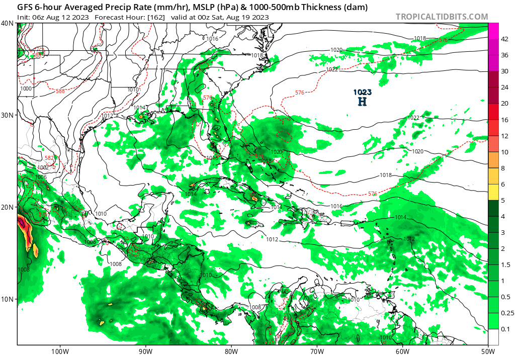
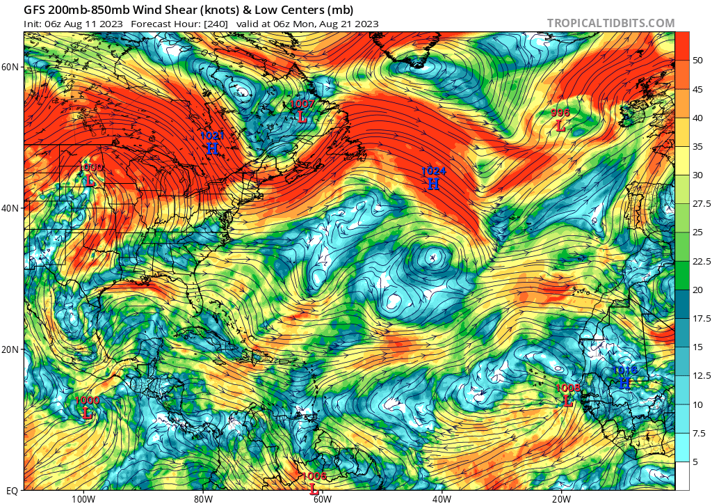
Spacecoast wrote:Teban54 wrote:gatorcane wrote:The GFS continues to insist that the favorable conditions will be over the EPAC and not the Atlantic over the next 10 days. The upper-level flow it is predicting does not look favorable for significant development across the MDR. Strong westerly flow across the Gulf, Florida, the SW Atlantic, and the Caribbean. Day 10 below:
https://i.postimg.cc/mrqX9kXm/gfs-shear-atl-41.png
Question: If we always say GFS is on drugs whenever it's alone in showing favorable conditions and blowing up a model cane, why should we treat it as gospel when it's alone in showing unfavorable conditions and not developing systems that other models are at least showing hints of?
We shouldn't treat any model as gospel. However, there is verification data available that describes success ratios, etc.
A high false positive rate, does not necessarily correlate to a high false negative rate. I have seen data indicating the GFS (in the past), had a significant false positive, but false negative verification data is difficult to find.
https://yaleclimateconnections.org/2023/06/which-hurricane-models-should-you-trust-in-2023/
<snip>
" The model with the highest success ratio (rewarding correct genesis forecasts combined with the fewest false alarms) was the European, followed by the UKMET, GFS, and Canadian models."
"The European model had the lowest probability of correctly making a genesis forecast – near 20% – but had the fewest false alarms. The GFS correctly made genesis forecasts 20 – 25% of the time but had more false alarms. The Canadian model had the best chance of making a correct genesis forecast but also had the highest number of false alarms. The take-home message: The Canadian model’s predicting genesis suggests something may be afoot, but don’t bet on it until the European model comes on board. In general, when two or more models make the same genesis forecast, the odds of the event actually occurring increase considerably."
Man, 20-25% of a correct genesis forecast (75-80% of not showing a model storm for something that eventually develops) seems ridiculously low, especially for the GFS.
0 likes
TC naming lists: retirements and intensity
Most aggressive Advisory #1's in North Atlantic (cr. kevin for starting the list)
Most aggressive Advisory #1's in North Atlantic (cr. kevin for starting the list)
Re: 2023 Global Model Runs Discussion (Out thru day 16)
BobHarlem wrote:12z Euro Ensembles
https://i.imgur.com/4MT7dIs.gif
Compared this to this time last year, it was ultra crickets on the EPS this date last year.
(AUG 12 EPS *** 2022 LAST YEAR *** BELOW):
https://i.ibb.co/XXs68x4/auga.jpg
1. Great comparison of the night vs day of 2022/23!
2. Compared to the last couple of EPS runs, this newest one is quite a bit less threatening, including at 228 on this vs 240 on the 0Z, as the average strength of members is weaker for that same wave.
1 likes
Personal Forecast Disclaimer:
The posts in this forum are NOT official forecasts and should not be used as such. They are just the opinion of the poster and may or may not be backed by sound meteorological data. They are NOT endorsed by any professional institution or storm2k.org. For official information, please refer to the NHC and NWS products.
The posts in this forum are NOT official forecasts and should not be used as such. They are just the opinion of the poster and may or may not be backed by sound meteorological data. They are NOT endorsed by any professional institution or storm2k.org. For official information, please refer to the NHC and NWS products.
-
Spacecoast

- Category 2

- Posts: 773
- Joined: Thu Aug 31, 2017 2:03 pm
Re: 2023 Global Model Runs Discussion (Out thru day 16)
Teban54 wrote:Man, 20-25% of a correct genesis forecast (75-80% of not showing a model storm for something that eventually develops) seems ridiculously low, especially for the GFS.
Pretty strict criteria for correct genesis...
"The relatively small POD values over the NATL are due mostly to TCs that the models miss (generally smaller TCs),and partly due to the models rarely being able to capture genesis in every forecast cycle during the 5 days before genesis occurs. For example, if a model correctly forecasts genesis 6 times out of 10 during the 5 days leading up to best-track genesis, that generally would be considered a successful forecast, but it only yields a POD of 0.6."

A “perfectly” performing model would be in the top-right corner of the plot, where 100% of all TC genesis was forecast (w correct time / location) on every run, and no false alarms(100% true negative, or SR on x axis) on any run.
- lower left: worst possible model,
upper left: "always forecasts" genesis everywhere,
lower right: "never forecasts genesis"
“Remember that all models are wrong; the practical question is how wrong do they have to be to not be useful.” George Box
Last edited by Spacecoast on Fri Aug 11, 2023 8:47 pm, edited 1 time in total.
0 likes

Re: 2023 Global Model Runs Discussion (Out thru day 16)
Apologies in advance because I suspect this question has been asked and answered before. How well do these models do in handling the effects of large Saharan dust incursions into the areas where development may occur?
1.e.
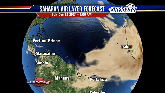
1.e.
3 likes
-
Hybridstorm_November2001

- S2K Supporter

- Posts: 2817
- Joined: Sat Aug 21, 2004 2:50 pm
- Location: SW New Brunswick, Canada
- Contact:
Re: 2023 Global Model Runs Discussion (Out thru day 16)
The abundance of dust is why I'm VERY SKEPTICAL of any MDR systems in the medium term (also perhaps for the next two weeks or longer) or if they do develop that they'll survive, but we'll see.
0 likes
Re: 2023 Global Model Runs Discussion (Out thru day 16)
0z GFS now develops a weak TS in the eastern MDR that quickly recurves.
With that, now all operational global models agree on TC development in the eastern MDR within the next 10 days.
With that, now all operational global models agree on TC development in the eastern MDR within the next 10 days.
0 likes
TC naming lists: retirements and intensity
Most aggressive Advisory #1's in North Atlantic (cr. kevin for starting the list)
Most aggressive Advisory #1's in North Atlantic (cr. kevin for starting the list)
-
lsuhurricane
- Category 1
- Posts: 270
- Joined: Tue Aug 15, 2017 2:53 pm
Re: 2023 Global Model Runs Discussion (Out thru day 16)
This 0z EPS run is absolutely nuts and very eye opening. Every possible outcome on the table during the 10-16 day mark. Paints the Eastern and Gulf Coasts with storms.

2 likes
-
Blown Away

- S2K Supporter
- Posts: 10253
- Joined: Wed May 26, 2004 6:17 am
Re: 2023 Global Model Runs Discussion (Out thru day 16)
06z GFS now makes that leading TW into a TS/Cat 1 hurricane into Florida.
1 likes
Hurricane Eye Experience: David 79, Irene 99, Frances 04, Jeanne 04, Wilma 05… Hurricane Brush Experience: Andrew 92, Erin 95, Floyd 99, Matthew 16, Irma 17, Ian 22, Nicole 22…
Re: 2023 Global Model Runs Discussion (Out thru day 16)
lsuhurricane wrote:This 0z EPS run is absolutely nuts and very eye opening. Every possible outcome on the table during the 10-16 day mark. Paints the Eastern and Gulf Coasts with storms.
https://i.ibb.co/JsQxMXT/14-km-EPS-Global-Cyclones-Tropical-Atlantic-Ens-MSLP-Spaghettios.gif
The period 8/23-27 looks like an extra risky period for the CONUS per ensembles as the ridging gives way to a trough. Bear watch in effect for the wave about to come off Africa.
3 likes
Personal Forecast Disclaimer:
The posts in this forum are NOT official forecasts and should not be used as such. They are just the opinion of the poster and may or may not be backed by sound meteorological data. They are NOT endorsed by any professional institution or storm2k.org. For official information, please refer to the NHC and NWS products.
The posts in this forum are NOT official forecasts and should not be used as such. They are just the opinion of the poster and may or may not be backed by sound meteorological data. They are NOT endorsed by any professional institution or storm2k.org. For official information, please refer to the NHC and NWS products.
-
jlauderdal
- S2K Supporter
- Posts: 7240
- Joined: Wed May 19, 2004 5:46 am
- Location: NE Fort Lauderdale
- Contact:
Re: 2023 Global Model Runs Discussion (Out thru day 16)
Blown Away wrote:[url]https://i.postimg.cc/59kXQCgW/gfs-mslp-pcpn-watl-fh162-306.gif [/url]
06z GFS now makes that leading TW into a TS/Cat 1 hurricane into Florida.
That ridge sticks around just long enough to give NE Florida the rare hit and the steering flow collapses, lets see if we can put a few runs together with some "consistency"...the 1935 labor day system was a legend, just sayin
1 likes
-
Blown Away
- S2K Supporter
- Posts: 10253
- Joined: Wed May 26, 2004 6:17 am
Re: 2023 Global Model Runs Discussion (Out thru day 16)
jlauderdal wrote:Blown Away wrote:[url]https://i.postimg.cc/59kXQCgW/gfs-mslp-pcpn-watl-fh162-306.gif [/url]
06z GFS now makes that leading TW into a TS/Cat 1 hurricane into Florida.
That ridge sticks around just long enough to give NE Florida the rare hit and the steering flow collapses, lets see if we can put a few runs together with some "consistency"...the 1935 labor day system was a legend, just sayin
00z CMC
00z Icon
Both appear to start developing then runs over big islands. Plenty of hot ocean water to develop quickly if upper levels are good.
0 likes
Hurricane Eye Experience: David 79, Irene 99, Frances 04, Jeanne 04, Wilma 05… Hurricane Brush Experience: Andrew 92, Erin 95, Floyd 99, Matthew 16, Irma 17, Ian 22, Nicole 22…
-
Blown Away
- S2K Supporter
- Posts: 10253
- Joined: Wed May 26, 2004 6:17 am
Re: 2023 Global Model Runs Discussion (Out thru day 16)
LarryWx wrote:lsuhurricane wrote:This 0z EPS run is absolutely nuts and very eye opening. Every possible outcome on the table during the 10-16 day mark. Paints the Eastern and Gulf Coasts with storms.
https://i.ibb.co/JsQxMXT/14-km-EPS-Global-Cyclones-Tropical-Atlantic-Ens-MSLP-Spaghettios.gif
The period 8/23-27 looks like an extra risky period for the CONUS per ensembles as the ridging gives way to a trough. Bear watch in effect for the wave about to come off Africa.

Lemon Watch In Effect For Eastern Atlantic
1 likes
Hurricane Eye Experience: David 79, Irene 99, Frances 04, Jeanne 04, Wilma 05… Hurricane Brush Experience: Andrew 92, Erin 95, Floyd 99, Matthew 16, Irma 17, Ian 22, Nicole 22…
-
gatorcane

- S2K Supporter
- Posts: 23708
- Age: 48
- Joined: Sun Mar 13, 2005 3:54 pm
- Location: Boca Raton, FL
Re: 2023 Global Model Runs Discussion (Out thru day 16)
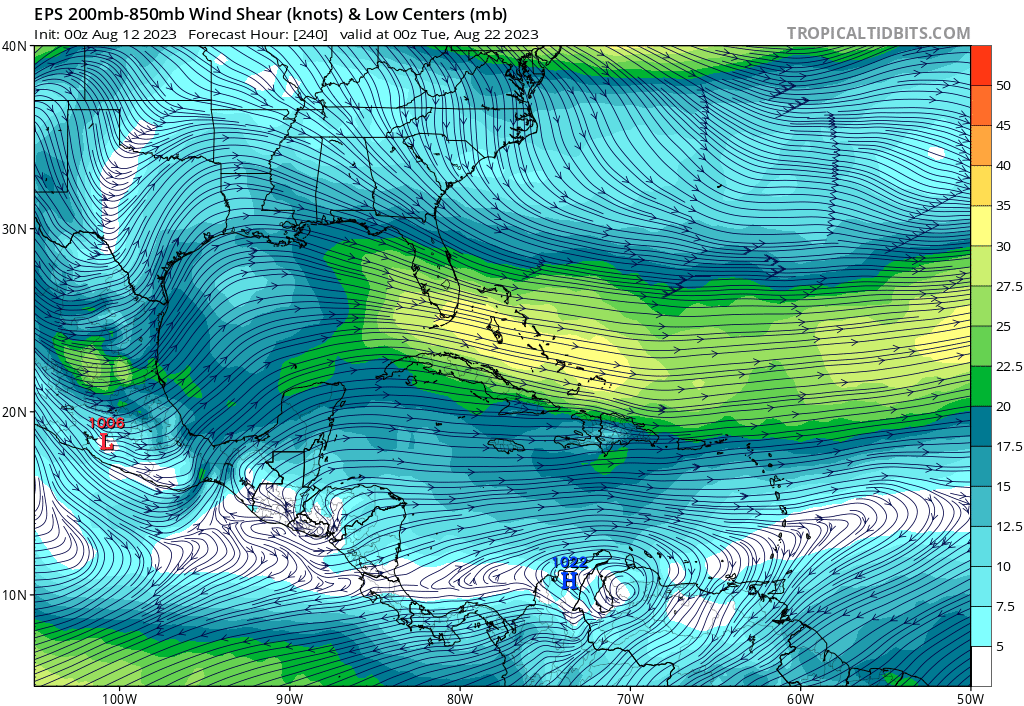
Guessing the GFS Bahamas storm will be gone next run. The EPS upper-level winds do not look favorable nor do they do on the GEFS:
0 likes

Re: 2023 Global Model Runs Discussion (Out thru day 16)
lsuhurricane wrote:This 0z EPS run is absolutely nuts and very eye opening. Every possible outcome on the table during the 10-16 day mark. Paints the Eastern and Gulf Coasts with storms.
https://i.ibb.co/JsQxMXT/14-km-EPS-Global-Cyclones-Tropical-Atlantic-Ens-MSLP-Spaghettios.gif
I’ve noticed the EPS wants to turn almost everything north that develops in the MDR. I really don’t remember but is it common for the EPS to do this or has it only been happening this year? That’s a lot of fish storms it’s cranking out.
0 likes
-
Blown Away
- S2K Supporter
- Posts: 10253
- Joined: Wed May 26, 2004 6:17 am
Re: 2023 Global Model Runs Discussion (Out thru day 16)
gatorcane wrote:Guessing the GFS Bahamas storm will be gone next run. The EPS upper-level winds do not look favorable nor do they do on the GEFS:
https://i.postimg.cc/SNtSd91h/eps-shear-watl-41.png
00z Euro, Icon, CMC at minimum have a strong TW over GA’s in @7 days that appears to deepen if not for land interaction.
00z Euro ensembles backed off from previous runs showing some development of this TW.
0 likes
Hurricane Eye Experience: David 79, Irene 99, Frances 04, Jeanne 04, Wilma 05… Hurricane Brush Experience: Andrew 92, Erin 95, Floyd 99, Matthew 16, Irma 17, Ian 22, Nicole 22…
-
Hypercane_Kyle

- Category 5

- Posts: 3465
- Joined: Sat Mar 07, 2015 7:58 pm
- Location: Cape Canaveral, FL
Re: 2023 Global Model Runs Discussion (Out thru day 16)
I think we're finally seeing signs this season is about to wake up from hibernation. Wouldn't really consider too strongly the fact the systems the GFS/Euro are showing are pretty weak. As we all have seen in the past, when hurricane season really turns on, it's usually with systems predicted to be weak 200+ hours out until suddenly they're not.
2 likes
My posts are my own personal opinion, defer to the National Hurricane Center (NHC) and other NOAA products for decision making during hurricane season.
Re: 2023 Global Model Runs Discussion (Out thru day 16)
Canadian vs GFS
Canadian

Western Atlantic wave is 989mb in that last frame.
GFS

Canadian
Western Atlantic wave is 989mb in that last frame.
GFS
0 likes
-
Category5Kaiju

- Category 5
- Posts: 4345
- Joined: Thu Dec 24, 2020 12:45 pm
- Location: Seattle during the summer, Phoenix during the winter
Re: 2023 Global Model Runs Discussion (Out thru day 16)
Hypercane_Kyle wrote:I think we're finally seeing signs this season is about to wake up from hibernation. Wouldn't really consider too strongly the fact the systems the GFS/Euro are showing are pretty weak. As we all have seen in the past, when hurricane season really turns on, it's usually with systems predicted to be weak 200+ hours out until suddenly they're not.
It's always the early to mid August timeframe where this seems to happen; I wonder if there's a way models could be more effective at showing the switch flip during this time period?
1 likes
Unless explicitly stated, all information in my posts is based on my own opinions and observations. Tropical storms and hurricanes can be extremely dangerous. Refer to an accredited weather research agency or meteorologist if you need to make serious decisions regarding an approaching storm.
Re: 2023 Global Model Runs Discussion (Out thru day 16)
BobHarlem wrote:Canadian vs GFS
Canadian
https://i.imgur.com/qRnhvKT.png
Western Atlantic wave is 989mb in that last frame.
So, the 12Z CMC is developing the bear/lemon watch wave about to come off/the one the EPS has been harping on to possibly threaten the CONUS. The 12Z Euro has this as a weak but possibly dangerous to Gulf Caribbean Cruiser.
0 likes
Personal Forecast Disclaimer:
The posts in this forum are NOT official forecasts and should not be used as such. They are just the opinion of the poster and may or may not be backed by sound meteorological data. They are NOT endorsed by any professional institution or storm2k.org. For official information, please refer to the NHC and NWS products.
The posts in this forum are NOT official forecasts and should not be used as such. They are just the opinion of the poster and may or may not be backed by sound meteorological data. They are NOT endorsed by any professional institution or storm2k.org. For official information, please refer to the NHC and NWS products.