
2023 Global Model Runs Discussion (Out thru day 16)
Moderator: S2k Moderators
Forum rules

The posts in this forum are NOT official forecasts and should not be used as such. They are just the opinion of the poster and may or may not be backed by sound meteorological data. They are NOT endorsed by any professional institution or STORM2K. For official information, please refer to products from the National Hurricane Center and National Weather Service.
Re: 2023 Global Model Runs Discussion (Out thru day 16)
The east Atlantic wave is much more organized on the 18z so far than 12z GFS, also that thing in the Gulf approaching Texas is an interesting signal also.
0 likes
-
Blown Away

- S2K Supporter

- Posts: 10253
- Joined: Wed May 26, 2004 6:17 am
Re: 2023 Global Model Runs Discussion (Out thru day 16)
IcyTundra wrote:The dry air in the MDR will continue to be a problem. Maybe some of these leading waves can help with reducing the dry air for future waves.
12z Euro ensembles & 18z GFS giving us a different look.
0 likes
Hurricane Eye Experience: David 79, Irene 99, Frances 04, Jeanne 04, Wilma 05… Hurricane Brush Experience: Andrew 92, Erin 95, Floyd 99, Matthew 16, Irma 17, Ian 22, Nicole 22…
-
Stratton23
- Category 5

- Posts: 3577
- Joined: Fri Jul 21, 2023 10:59 pm
- Location: Katy, Tx
Re: 2023 Global Model Runs Discussion (Out thru day 16)
18z GFS has something forming in the yucatan channel as well, definitely one of the more active runs in a while
1 likes
Re: 2023 Global Model Runs Discussion (Out thru day 16)
18Z GFS has 4 areas of interest.
1. Early next week in the GOM the GFS has some vorticity that moves westward into Texas. Euro and CMC try to make it into a weak system as it approaches Texas.
2. Tropical wave about to come off of Africa. Gets down to 991 MB west of Cabo Verde but begins to weaken and moves westward.
3. 2nd MDR system that is weak probably won't happen because it has issues handling the monsoon trough.
4. Development in the WCAR in about 10 days.
0 likes
-
Blown Away
- S2K Supporter
- Posts: 10253
- Joined: Wed May 26, 2004 6:17 am
Re: 2023 Global Model Runs Discussion (Out thru day 16)
18z GFS… Big shift W in TW off Africa, makes big NW jump near Cape Verde then beeline W. Same time GOM cane into Texas. GFS keeps teasing us with the GOM storm.
0 likes
Hurricane Eye Experience: David 79, Irene 99, Frances 04, Jeanne 04, Wilma 05… Hurricane Brush Experience: Andrew 92, Erin 95, Floyd 99, Matthew 16, Irma 17, Ian 22, Nicole 22…
-
Spacecoast

- Category 2

- Posts: 773
- Joined: Thu Aug 31, 2017 2:03 pm
Re: 2023 Global Model Runs Discussion (Out thru day 16)
12z EPS: Shows two different areas for Hurricane development (~15% probability) on Day 11

0 likes
-
Blown Away
- S2K Supporter
- Posts: 10253
- Joined: Wed May 26, 2004 6:17 am
Re: 2023 Global Model Runs Discussion (Out thru day 16)
18z GFS… GOM came back w/ Cat 2 into TX… Huge W shift for MDR TW, struggles w/ dry air across MDR and finds better conditions in SW Atlantic. Weird NW motion over Cape Verde, will that flatten out and TW won’t gain the latitude before riding under HP??? 18z GEFS should be interesting…
0 likes
Hurricane Eye Experience: David 79, Irene 99, Frances 04, Jeanne 04, Wilma 05… Hurricane Brush Experience: Andrew 92, Erin 95, Floyd 99, Matthew 16, Irma 17, Ian 22, Nicole 22…
-
hurricane2025
- Category 1

- Posts: 254
- Joined: Thu Apr 08, 2021 10:36 am
Re: 2023 Global Model Runs Discussion (Out thru day 16)
What I notice with gfs right stout ridge on east coast all the way down to Florida and tons of moisture in gulf
Last edited by hurricane2025 on Sun Aug 13, 2023 9:26 pm, edited 1 time in total.
2 likes

Re: 2023 Global Model Runs Discussion (Out thru day 16)
18z GFS ensembles are very active for Florida starting Aug 24th and later. Most of the hits look like from cat1 hurricanes though, not a lot of major members in it. Looks due to land interaction. Still, kinda eye popping if they can avoid land they could be stronger.
0 likes
-
jlauderdal
- S2K Supporter
- Posts: 7240
- Joined: Wed May 19, 2004 5:46 am
- Location: NE Fort Lauderdale
- Contact:
Re: RE: Re: 2023 Global Model Runs Discussion (Out thru day 16)
Bear watch at most considerng the not so good conditionsIanswfl wrote:18z GFS ensembles are very active for Florida starting Aug 24th and later. Most of the hits look like from cat1 hurricanes though, not a lot of major members in it. Looks due to land interaction. Still, kinda eye popping if they can avoid land they could be stronger.
0 likes
Re: RE: Re: 2023 Global Model Runs Discussion (Out thru day 16)
jlauderdal wrote:Bear watch at most considerng the not so good conditionsIanswfl wrote:18z GFS ensembles are very active for Florida starting Aug 24th and later. Most of the hits look like from cat1 hurricanes though, not a lot of major members in it. Looks due to land interaction. Still, kinda eye popping if they can avoid land they could be stronger.
One nasty member is from a different system on Aug 29th. Cat4ish hits Key West then same place as Michael. The 24 to 26th system looks like it's the front wave but doesn't crank until around Cuba. But an uptick for sure. With the hot waters, you could have a Charley like intensity instead. Similar path.
1 likes

Re: 2023 Global Model Runs Discussion (Out thru day 16)
Boy, that is a lot of action going on in the Gulf on the 18z GEFS. 
2 likes
Re: 2023 Global Model Runs Discussion (Out thru day 16)

EPS has some sort of CAG in day 10-15 range.
0 likes
Re: 2023 Global Model Runs Discussion (Out thru day 16)
GFS runs since 7/31 with hurricane: 3 of last 4
-7/31 12Z: hit SC 8/16
-8/3 6Z: hit MX/TX border 8/16
-8/6 0Z: MDR 8/18-21
-8/9 18Z: just off SC 8/25
-8/11 0Z: GOM just off LA 8/26
-8/13 0Z: GOM 8/26-8
-8/13 6Z: GOM 8/25-6 that hits MS 8/26-7.
-8/13 18Z: GOM 8/25 hits S TX 8/26
-7/31 12Z: hit SC 8/16
-8/3 6Z: hit MX/TX border 8/16
-8/6 0Z: MDR 8/18-21
-8/9 18Z: just off SC 8/25
-8/11 0Z: GOM just off LA 8/26
-8/13 0Z: GOM 8/26-8
-8/13 6Z: GOM 8/25-6 that hits MS 8/26-7.
-8/13 18Z: GOM 8/25 hits S TX 8/26
1 likes
Personal Forecast Disclaimer:
The posts in this forum are NOT official forecasts and should not be used as such. They are just the opinion of the poster and may or may not be backed by sound meteorological data. They are NOT endorsed by any professional institution or storm2k.org. For official information, please refer to the NHC and NWS products.
The posts in this forum are NOT official forecasts and should not be used as such. They are just the opinion of the poster and may or may not be backed by sound meteorological data. They are NOT endorsed by any professional institution or storm2k.org. For official information, please refer to the NHC and NWS products.

Re: 2023 Global Model Runs Discussion (Out thru day 16)
zzzh wrote:https://i.imgur.com/PNlvKAi.png
EPS has some sort of CAG in day 10-15 range.
Wasn't it mentioned last season that there are zero CAG events on record in August?
0 likes
TC naming lists: retirements and intensity
Most aggressive Advisory #1's in North Atlantic (cr. kevin for starting the list)
Most aggressive Advisory #1's in North Atlantic (cr. kevin for starting the list)
-
Blown Away
- S2K Supporter
- Posts: 10253
- Joined: Wed May 26, 2004 6:17 am
Re: 2023 Global Model Runs Discussion (Out thru day 16)
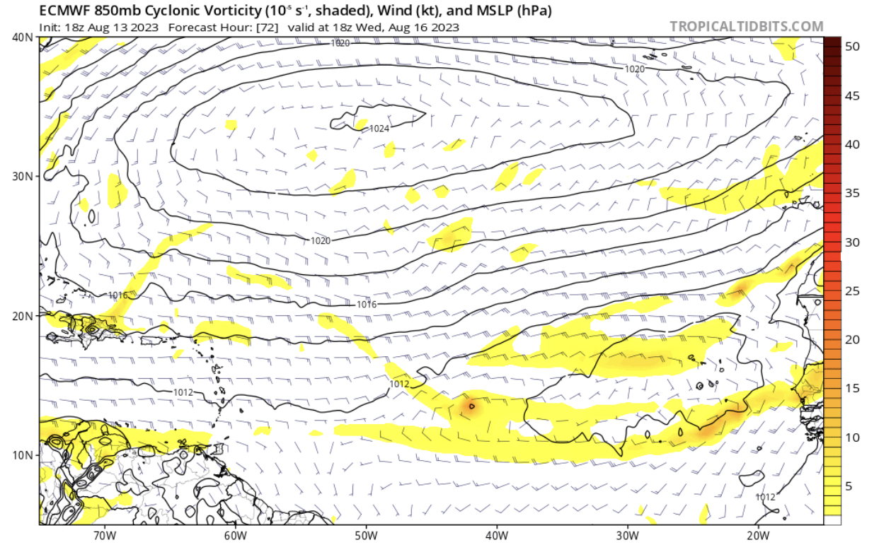
18z Euro… Now shows a low developing in the Central Atlantic… GFS is slower and farther N, probably due to that early NNW jog near Cape Verde… IMO, both Euro/GFS somewhat agreeing on a TW moving across the Atlantic…
0 likes
Hurricane Eye Experience: David 79, Irene 99, Frances 04, Jeanne 04, Wilma 05… Hurricane Brush Experience: Andrew 92, Erin 95, Floyd 99, Matthew 16, Irma 17, Ian 22, Nicole 22…
Re: 2023 Global Model Runs Discussion (Out thru day 16)
Teban54 wrote:zzzh wrote:https://i.imgur.com/PNlvKAi.png
EPS has some sort of CAG in day 10-15 range.
Wasn't it mentioned last season that there are zero CAG events on record in August?
https://twitter.com/weatherffolkes/status/1690769165924102144
I am not sure on this because Dr. Papin's paper says no August CAG has been observed.

The main reason why there are little CAG events in August is due to the strong trade. (Note there are 3 CAG events identified in first week of Sep)

However, with the strong westerlies EPS is showing, I wouldn't say the conditions for CAG in the last week of August is much different that the first week of September.
0 likes
Re: 2023 Global Model Runs Discussion (Out thru day 16)
18z euro ensembles out to 144 looks more active and a bit more south with the first wave as well.
0 likes
Who is online
Users browsing this forum: gib, Google Adsense [Bot] and 105 guests