
2023 Global Model Runs Discussion (Out thru day 16)
Moderator: S2k Moderators
Forum rules

The posts in this forum are NOT official forecasts and should not be used as such. They are just the opinion of the poster and may or may not be backed by sound meteorological data. They are NOT endorsed by any professional institution or STORM2K. For official information, please refer to products from the National Hurricane Center and National Weather Service.
-
Spacecoast

- Category 2

- Posts: 773
- Joined: Thu Aug 31, 2017 2:03 pm
Re: 2023 Global Model Runs Discussion (Out thru day 16)
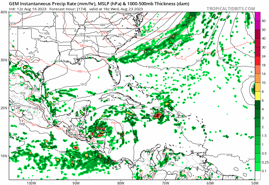
Busy genesis map.... (except NAV, which is close)
0 likes
Re: 2023 Global Model Runs Discussion (Out thru day 16)
Stratton23 wrote:And 18z GFS shifts north some with a slightly more organized gulf system, last run was into brownsville, this run south padre island, slightly weaker ridge, it aint over till its over
This run is a strengthening cat1 hurricane going over the Keys and into South FL. Over those hot waters. Get it 75 miles more west and that could blow up fast into SWFL instead. Trof sucks it up out of the Caribbean. Seems like another Aug storm that did that.
Edit more like an Irene `1999 storm into the Cape Sable area.
0 likes

Re: 2023 Global Model Runs Discussion (Out thru day 16)
Stratton23 wrote:Its way too soon to rule out texas, considering a landfall is still 8 days out and we dont even have a closed low yet, alot can change, texas and the middle -upper texas coastline are still very much in play, and besides most models show NE Mexico- S texas landfall, it wouldnt take much weaking of the ridge for that track to shift north again
Anything the models show past 5 days for a landfall can be taken with a massive grain of salt
A stronger system would track a little more north, yes/no?
0 likes
-
Stratton23
- Category 5

- Posts: 3574
- Joined: Fri Jul 21, 2023 10:59 pm
- Location: Katy, Tx
Re: 2023 Global Model Runs Discussion (Out thru day 16)
Texoz I would imagine a stronger storm would be able to gain more latitude, not 100% certain on that though
1 likes
-
wxman57

- Moderator-Pro Met

- Posts: 23175
- Age: 68
- Joined: Sat Jun 21, 2003 8:06 pm
- Location: Houston, TX (southwest)
Re: 2023 Global Model Runs Discussion (Out thru day 16)
Texoz wrote:Stratton23 wrote:Its way too soon to rule out texas, considering a landfall is still 8 days out and we dont even have a closed low yet, alot can change, texas and the middle -upper texas coastline are still very much in play, and besides most models show NE Mexico- S texas landfall, it wouldnt take much weaking of the ridge for that track to shift north again
Anything the models show past 5 days for a landfall can be taken with a massive grain of salt
A stronger system would track a little more north, yes/no?
Nothing can move farther north if the ridge doesn't retreat. Doesn't matter if it's a TD or Cat 5.
1 likes
-
cycloneye

- Admin

- Posts: 149696
- Age: 69
- Joined: Thu Oct 10, 2002 10:54 am
- Location: San Juan, Puerto Rico
Re: 2023 Global Model Runs Discussion (Out thru day 16)
Hey folks. Now that we have an AOI in GOM, all the model runs about that area will be posted at the Possible Development in GOMEX Next Week thread.
2 likes
Visit the Caribbean-Central America Weather Thread where you can find at first post web cams,radars
and observations from Caribbean basin members Click Here
and observations from Caribbean basin members Click Here
-
lsuhurricane
- Category 1

- Posts: 270
- Joined: Tue Aug 15, 2017 2:53 pm
Possible development in GOM
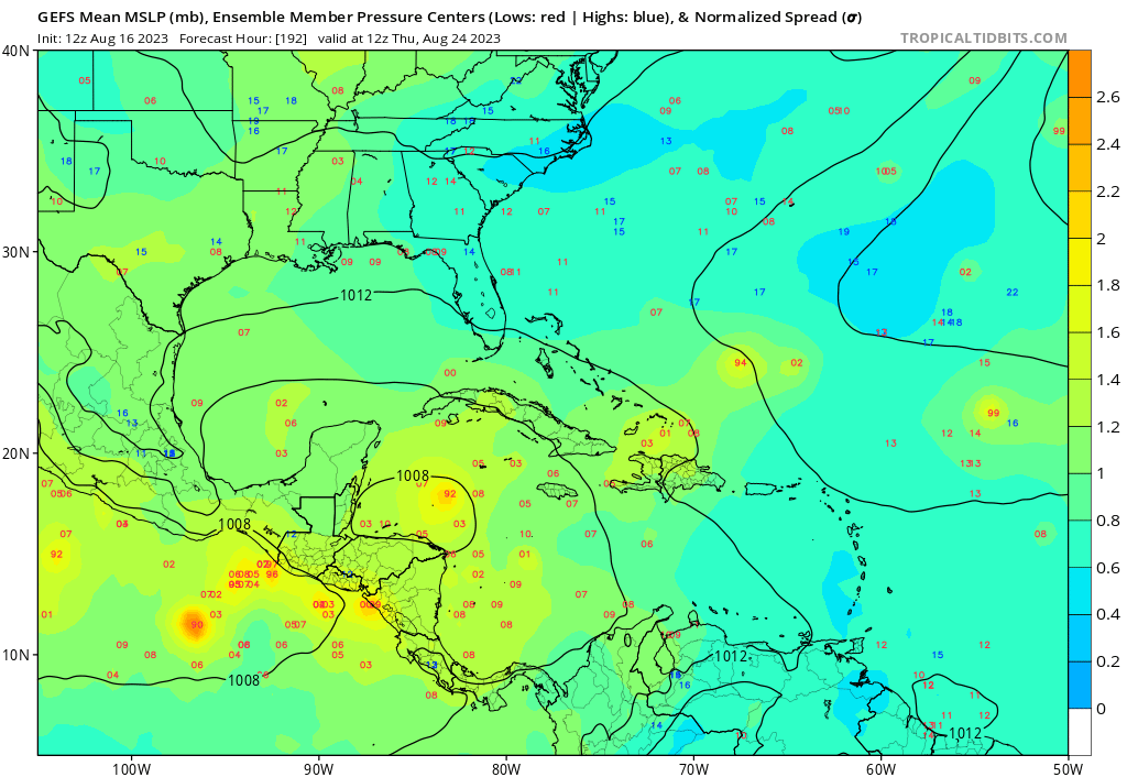
GEFS (18z this go round) is relentless with Caribbean/Yucatan development.

1 likes

Re: Possible development in GOM
lsuhurricane wrote:GEFS (18z this go round) is relentless with Caribbean/Yucatan development.
https://i.ibb.co/x5Pm3c3/GEFS-Global-Cyclones-Caribbean-Ens-MSLP-Spaghettios.gif
Sheesh, that’s an eye opener for sure.
0 likes
Re: 2023 Global Model Runs Discussion (Out thru day 16)
The 0Z UKMET has a new TS form in the far E MDR in a week moving WNW:
NEW TROPICAL CYCLONE FORECAST TO DEVELOP AFTER 156 HOURS
FORECAST POSITION AT T+156 : 10.5N 16.9W
LEAD CENTRAL MAXIMUM WIND
VERIFYING TIME TIME POSITION PRESSURE (MB) SPEED (KNOTS)
-------------- ---- -------- ------------- -------------
1200UTC 22.08.2023 156 10.5N 16.9W 1006 28
0000UTC 23.08.2023 168 11.1N 19.4W 1006 35
0 likes
Personal Forecast Disclaimer:
The posts in this forum are NOT official forecasts and should not be used as such. They are just the opinion of the poster and may or may not be backed by sound meteorological data. They are NOT endorsed by any professional institution or storm2k.org. For official information, please refer to the NHC and NWS products.
The posts in this forum are NOT official forecasts and should not be used as such. They are just the opinion of the poster and may or may not be backed by sound meteorological data. They are NOT endorsed by any professional institution or storm2k.org. For official information, please refer to the NHC and NWS products.
-
USTropics
- Professional-Met

- Posts: 2739
- Joined: Sun Aug 12, 2007 3:45 am
- Location: Florida State University
Re: 2023 Global Model Runs Discussion (Out thru day 16)
5-day forecast trend of the GFS (last 8 runs), quite the adjustment in activity:

3 likes
-
REDHurricane

- Category 1
- Posts: 438
- Age: 28
- Joined: Sun Jul 03, 2022 2:36 pm
- Location: Northeast Pacific Ocean
Re: 2023 Global Model Runs Discussion (Out thru day 16)
All three major models showing a very similar picture just six days out -- two separate MDR systems trying to develop out of the monsoon trough moving to the northwest and an area of increased vorticity somewhere in the Gulf heading pretty much due west:
00z GFS +144 hours

00z ECMWF +144 hours

00z CMC +144 hours

GFS develops the leading/blue MDR wave (NHC disturbance 1) and not the trailing/green wave (NHC disturbance 2), ECMWF shows the blue wave absorbing the green wave and possibly turning into a TD/weak TS, and CMC has the opposite with the green wave swallowing the blue one, so we'll probably just have to wait until the LLCs actually form to see what will happen in the MDR. However, on all three operational runs I think the system trying to develop in the Gulf of Jacuzzi in 5-7 days (NHC disturbance 3) looks like it'll be from the purple tropical wave that is currently approaching Puerto Rico, so the model consistency less than a week out makes me think the odds are pretty decent (40-50%) that something tries to spin up, possibly becoming Emily if neither of the MDR disturbances form before then. I wouldn't be surprised if the NHC updates the lemon to an orange in the next couple of days if the model consistency persists.

00z GFS +144 hours
00z ECMWF +144 hours
00z CMC +144 hours
GFS develops the leading/blue MDR wave (NHC disturbance 1) and not the trailing/green wave (NHC disturbance 2), ECMWF shows the blue wave absorbing the green wave and possibly turning into a TD/weak TS, and CMC has the opposite with the green wave swallowing the blue one, so we'll probably just have to wait until the LLCs actually form to see what will happen in the MDR. However, on all three operational runs I think the system trying to develop in the Gulf of Jacuzzi in 5-7 days (NHC disturbance 3) looks like it'll be from the purple tropical wave that is currently approaching Puerto Rico, so the model consistency less than a week out makes me think the odds are pretty decent (40-50%) that something tries to spin up, possibly becoming Emily if neither of the MDR disturbances form before then. I wouldn't be surprised if the NHC updates the lemon to an orange in the next couple of days if the model consistency persists.
The posts in this forum are NOT official forecasts and should not be used as such. They are just the opinion of the poster and may or may not be backed by sound meteorological data. They are NOT endorsed by any professional institution or STORM2K. For official information, please refer to products from the NHC and NWS.
4 likes
Re: 2023 Global Model Runs Discussion (Out thru day 16)
LarryWx wrote:The 0Z UKMET has a new TS form in the far E MDR in a week moving WNW:
NEW TROPICAL CYCLONE FORECAST TO DEVELOP AFTER 156 HOURS
FORECAST POSITION AT T+156 : 10.5N 16.9W
LEAD CENTRAL MAXIMUM WIND
VERIFYING TIME TIME POSITION PRESSURE (MB) SPEED (KNOTS)
-------------- ---- -------- ------------- -------------
1200UTC 22.08.2023 156 10.5N 16.9W 1006 28
0000UTC 23.08.2023 168 11.1N 19.4W 1006 35
The 12Z UKMET is similar to the prior run with a new TC in the far E MDR at 168:
NEW TROPICAL CYCLONE FORECAST TO DEVELOP AFTER 168 HOURS
FORECAST POSITION AT T+168 : 12.1N 20.3W
LEAD CENTRAL MAXIMUM WIND
VERIFYING TIME TIME POSITION PRESSURE (MB) SPEED (KNOTS)
-------------- ---- -------- ------------- -------------
1200UTC 23.08.2023 168 12.1N 20.3W 1006 30
0 likes
Personal Forecast Disclaimer:
The posts in this forum are NOT official forecasts and should not be used as such. They are just the opinion of the poster and may or may not be backed by sound meteorological data. They are NOT endorsed by any professional institution or storm2k.org. For official information, please refer to the NHC and NWS products.
The posts in this forum are NOT official forecasts and should not be used as such. They are just the opinion of the poster and may or may not be backed by sound meteorological data. They are NOT endorsed by any professional institution or storm2k.org. For official information, please refer to the NHC and NWS products.
-
Stratton23
- Category 5
- Posts: 3574
- Joined: Fri Jul 21, 2023 10:59 pm
- Location: Katy, Tx
Re: 2023 Global Model Runs Discussion (Out thru day 16)
Lol the 12z GFS has a very active CAG
0 likes
Re: 2023 Global Model Runs Discussion (Out thru day 16)
SFLcane wrote:https://i.postimg.cc/50hbZYZL/ghghgh.gif
Waters are hot in that part off SWFl. goes from 990mb to 985. That could blow up quick before landfall in SWFL like another storm that was small did in 2004.
0 likes
-
SFLcane

- S2K Supporter

- Posts: 10281
- Age: 48
- Joined: Sat Jun 05, 2010 1:44 pm
- Location: Lake Worth Florida
Re: 2023 Global Model Runs Discussion (Out thru day 16)
Decent signal surely.. worth watching
1 likes
Re: 2023 Global Model Runs Discussion (Out thru day 16)
Just have to hope that there will be a unfavorable environment if it gets lifted northward.
0 likes
-
gatorcane

- S2K Supporter
- Posts: 23708
- Age: 48
- Joined: Sun Mar 13, 2005 3:54 pm
- Location: Boca Raton, FL
Re: 2023 Global Model Runs Discussion (Out thru day 16)
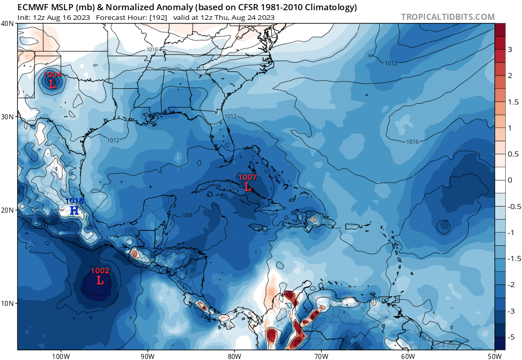
Conditions do not look particularly favorable for Caribbean CAG development as shown by the GFS and the latest Euro with a weak, sloppy system but given the time of year and high SSTs, worth watching. Also notice the Euro is showing more EPAC development:
0 likes
-
jlauderdal
- S2K Supporter
- Posts: 7240
- Joined: Wed May 19, 2004 5:46 am
- Location: NE Fort Lauderdale
- Contact:
Re: 2023 Global Model Runs Discussion (Out thru day 16)
gatorcane wrote:Conditions do not look particularly favorable for Caribbean CAG development as shown by the GFS and the latest Euro with a weak, sloppy system but given the time of year and high SSTs, worth watching. Also notice the Euro is showing more EPAC development:
https://i.postimg.cc/15yRwLVH/ec-fast-mslpa-Norm-watl-9.png
More of the same with model inconsistency, lots to talk about but in reality, not much to really be concerned about for now.
2 likes
Who is online
Users browsing this forum: No registered users and 202 guests