
EPAC: HILARY - Post-Tropical - Discussion
Moderator: S2k Moderators
-
Sciencerocks
- Category 5

- Posts: 10193
- Age: 40
- Joined: Thu Jul 06, 2017 1:51 am
-
Kingarabian

- S2K Supporter

- Posts: 16379
- Joined: Sat Aug 08, 2009 3:06 am
- Location: Honolulu, Hawaii
-
cycloneye

- Admin

- Posts: 149719
- Age: 69
- Joined: Thu Oct 10, 2002 10:54 am
- Location: San Juan, Puerto Rico
Re: EPAC: INVEST 90E - Discussion
Off the Coast of Southwestern Mexico (EP90):
Showers and thunderstorms are beginning to show signs of
organization in association with a broad area of low pressure
located a few hundred miles south of Acapulco, Mexico.
Environmental conditions appear conducive for continued development,
and a tropical depression or tropical storm is anticipated to form
within the next day or so. The system is expected to move
west-northwestward to northwestward, roughly parallel to the coast
of southwestern Mexico and the Baja California peninsula during the
next several days. Additional information on this system, including
gale warnings, can be found in High Seas Forecasts issued by the
National Weather Service.
* Formation chance through 48 hours...high...90 percent.
* Formation chance through 7 days...high...90 percent.
0 likes
Visit the Caribbean-Central America Weather Thread where you can find at first post web cams,radars
and observations from Caribbean basin members Click Here
and observations from Caribbean basin members Click Here
-
Sciencerocks
- Category 5
- Posts: 10193
- Age: 40
- Joined: Thu Jul 06, 2017 1:51 am

-
cycloneye
- Admin
- Posts: 149719
- Age: 69
- Joined: Thu Oct 10, 2002 10:54 am
- Location: San Juan, Puerto Rico
Re: EPAC: INVEST 90E - Discussion
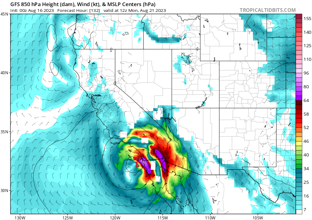
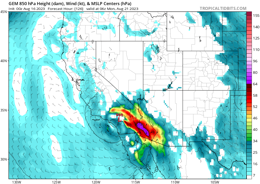
Many ensemble members of GFS make landfall in Baja California and move to SW U.S.

0 likes
Visit the Caribbean-Central America Weather Thread where you can find at first post web cams,radars
and observations from Caribbean basin members Click Here
and observations from Caribbean basin members Click Here
-
cycloneye
- Admin
- Posts: 149719
- Age: 69
- Joined: Thu Oct 10, 2002 10:54 am
- Location: San Juan, Puerto Rico
Re: EPAC: INVEST 90E - Discussion
It looks more and more that the squadron will be needed as the threat to Baja California and the SW U.S increases.
1 likes
Visit the Caribbean-Central America Weather Thread where you can find at first post web cams,radars
and observations from Caribbean basin members Click Here
and observations from Caribbean basin members Click Here
-
Yellow Evan

- Professional-Met

- Posts: 16257
- Age: 27
- Joined: Fri Jul 15, 2011 12:48 pm
- Location: Henderson, Nevada/Honolulu, HI
- Contact:
Re: EPAC: INVEST 90E - Discussion
Slowly organizing but I'd like to see ASCAT before classifying.
0 likes
-
Yellow Evan
- Professional-Met
- Posts: 16257
- Age: 27
- Joined: Fri Jul 15, 2011 12:48 pm
- Location: Henderson, Nevada/Honolulu, HI
- Contact:
Re: EPAC: INVEST 90E - Discussion
TXPZ25 KNES 160026
TCSENP
A. TROPICAL DISTURBANCE (90E)
B. 16/0000Z
C. 11.2N
D. 99.3W
E. FIVE/GOES-E
F. T1.0/1.0
G. IR/EIR/VIS
H. REMARKS...GREATER THAN 0.2 BANDING RESULTS IN A DT OF 1.0. THE MET
AND THE PT ARE BOTH 1.0 AS WELL. THE FT IS BASED ON THE DT.
I. ADDL POSITIONS
NIL
...HOSLEY
TCSENP
A. TROPICAL DISTURBANCE (90E)
B. 16/0000Z
C. 11.2N
D. 99.3W
E. FIVE/GOES-E
F. T1.0/1.0
G. IR/EIR/VIS
H. REMARKS...GREATER THAN 0.2 BANDING RESULTS IN A DT OF 1.0. THE MET
AND THE PT ARE BOTH 1.0 AS WELL. THE FT IS BASED ON THE DT.
I. ADDL POSITIONS
NIL
...HOSLEY
0 likes
-
Iceresistance

- Category 5
- Posts: 9607
- Age: 22
- Joined: Sat Oct 10, 2020 9:45 am
- Location: Tecumseh, OK/Norman, OK
Re: EPAC: INVEST 90E - Discussion
cycloneye wrote:Many ensemble members of GFS make landfall in Baja California and move to SW U.S.
https://i.imgur.com/ZQ7x0Dq.png
This will kickstart the Monsoon Season into high gear, it has been a few years since a Tropical Cyclone (Other than Kay) directly made a huge influx of moisture into the Desert SW
0 likes
Bill 2015 & Beta 2020
Winter 2020-2021
All observations are in Tecumseh, OK unless otherwise noted.
Winter posts are focused mainly for Oklahoma & Texas.
Take any of my forecasts with a grain of salt, refer to the NWS, SPC, and NHC for official information
Never say Never with weather! Because ANYTHING is possible!
Winter 2020-2021
All observations are in Tecumseh, OK unless otherwise noted.
Winter posts are focused mainly for Oklahoma & Texas.
Take any of my forecasts with a grain of salt, refer to the NWS, SPC, and NHC for official information
Never say Never with weather! Because ANYTHING is possible!


-
Yellow Evan
- Professional-Met
- Posts: 16257
- Age: 27
- Joined: Fri Jul 15, 2011 12:48 pm
- Location: Henderson, Nevada/Honolulu, HI
- Contact:
Re: EPAC: INVEST 90E - Discussion

90E + upper level low should draw up significant moisture to the Western US for about 2-3 days - I’m fairly confident in this atp.
SSTs of California are literally 20C. Tough for a tropical cyclone to maintain itself over that even if it’s only two days past peak intensity.
0 likes
-
Kingarabian
- S2K Supporter
- Posts: 16379
- Joined: Sat Aug 08, 2009 3:06 am
- Location: Honolulu, Hawaii
Re: EPAC: INVEST 90E - Discussion
Yellow Evan wrote:https://media.discordapp.net/attachments/733552978572869632/1141223540100706375/gfs_midRH_swus_24.png
90E + upper level low should draw up significant moisture to the Western US for about 2-3 days - I’m fairly confident in this atp.
SSTs of California are literally 20C. Tough for a tropical cyclone to maintain itself over that even if it’s only two days past peak intensity.
If the steering is right and there is to be a landfall, I give this a high 20% chance it reaches SoCal as a moderate TC. It'll begin to spin down once it approaches Baja, but it looks like its movement speed + large size may allow some history to be made.
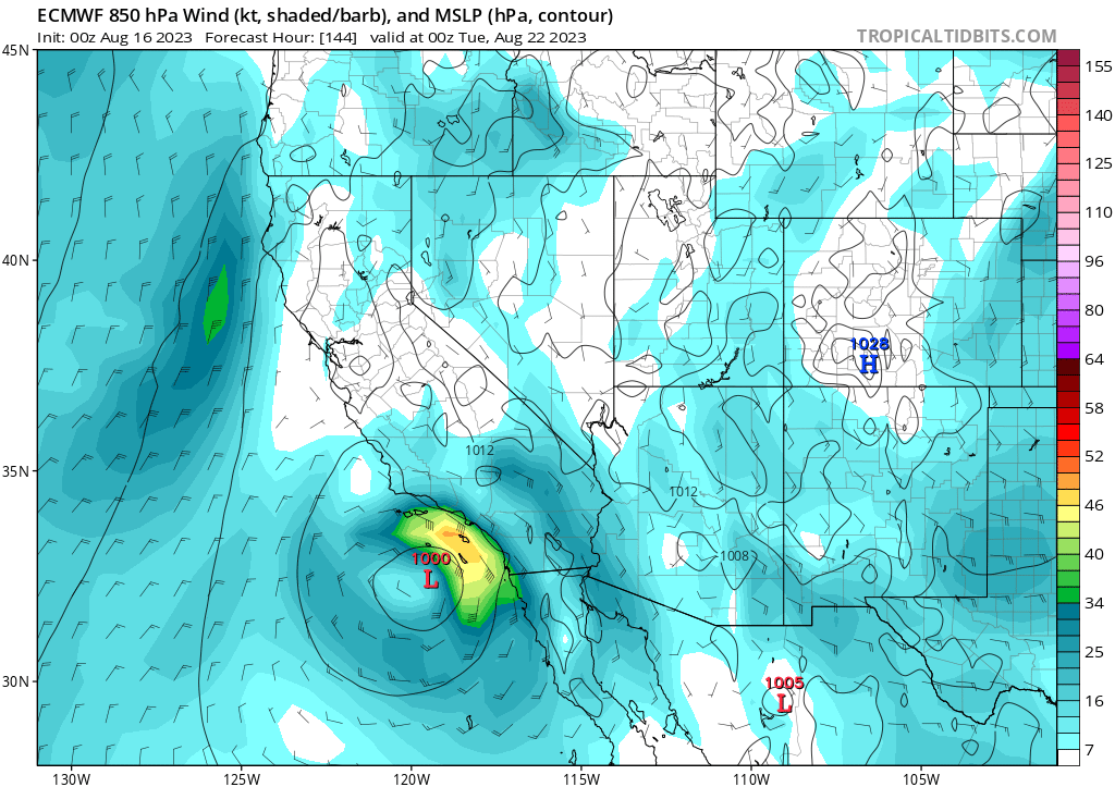
Euro is about 24hrs slower than the GFS/CMC and it almost gets there.
1 likes
RIP Kobe Bryant
-
cycloneye
- Admin
- Posts: 149719
- Age: 69
- Joined: Thu Oct 10, 2002 10:54 am
- Location: San Juan, Puerto Rico
Re: EPAC: INVEST 90E - Discussion
Already at TS strengh.
EP, 90, 2023081606, , BEST, 0, 117N, 1008W, 35, 1002, LO
1 likes
Visit the Caribbean-Central America Weather Thread where you can find at first post web cams,radars
and observations from Caribbean basin members Click Here
and observations from Caribbean basin members Click Here
-
cycloneye
- Admin
- Posts: 149719
- Age: 69
- Joined: Thu Oct 10, 2002 10:54 am
- Location: San Juan, Puerto Rico
Re: EPAC: INVEST 90E - Discussion
Off the Coast of Southwestern Mexico (EP90):
Showers and thunderstorms are continuing to show signs of
organization in association with a broad area of low pressure
located several hundred miles south-southeast of Manzanillo, Mexico.
Environmental conditions appear conducive for continued development,
and a tropical depression or tropical storm is likely to form within
the next day or so. The system is expected to move
west-northwestward to northwestward, roughly parallel to the coast
of southwestern Mexico and the Baja California peninsula during the
next several days. Additional information on this system, including
gale warnings, can be found in High Seas Forecasts issued by the
National Weather Service.
* Formation chance through 48 hours...high...90 percent.
* Formation chance through 7 days...high...90 percent.
0 likes
Visit the Caribbean-Central America Weather Thread where you can find at first post web cams,radars
and observations from Caribbean basin members Click Here
and observations from Caribbean basin members Click Here
-
cycloneye
- Admin
- Posts: 149719
- Age: 69
- Joined: Thu Oct 10, 2002 10:54 am
- Location: San Juan, Puerto Rico
Re: EPAC: INVEST 90E - Discussion
GFS version *
* EAST PACIFIC 2023 SHIPS INTENSITY FORECAST *
* IR SAT DATA AVAILABLE, OHC AVAILABLE *
* INVEST EP902023 08/16/23 12 UTC *
TIME (HR) 0 6 12 18 24 36 48 60 72 84 96 108 120 132 144 156 168
V (KT) NO LAND 35 42 52 63 74 97 117 126 128 123 109 89 69 45 38 N/A N/A
V (KT) LAND 35 42 52 63 74 97 117 126 128 123 109 89 69 45 38 N/A N/A
V (KT) LGEM 35 39 45 53 63 91 127 149 145 115 81 55 34 21 15 N/A N/A
Storm Type TROP TROP TROP TROP TROP TROP TROP TROP TROP TROP TROP TROP TROP EXTP EXTP N/A N/A
SHEAR (KT) 12 11 9 8 3 5 7 2 7 3 2 10 13 13 23 N/A N/A
SHEAR ADJ (KT) -5 -6 -8 -6 -6 -8 -8 -1 -1 4 1 0 0 -1 0 N/A N/A
SHEAR DIR 25 35 34 20 330 92 31 153 90 143 141 182 192 192 197 N/A N/A
SST (C) 30.0 30.1 30.1 29.9 29.7 30.1 30.0 30.2 28.7 25.8 24.0 21.6 20.1 20.1 17.4 N/A N/A
POT. INT. (KT) 166 167 167 165 163 167 166 168 152 123 105 80 64 62 61 N/A N/A
200 MB T (C) -51.9 -51.3 -50.9 -51.3 -51.3 -50.3 -50.6 -49.4 -49.5 -48.4 -48.1 -47.5 -47.6 -48.2 -49.5 N/A N/A
200 MB VXT (C) 0.4 0.5 0.6 0.7 0.6 0.8 1.0 1.0 1.4 1.5 1.8 1.5 1.6 1.2 0.0 N/A N/A
TH_E DEV (C) 4 5 5 6 6 6 6 6 4 3 2 3 1 2 1 N/A N/A
700-500 MB RH 85 84 84 86 87 84 84 79 75 64 56 49 44 38 26 N/A N/A
MODEL VTX (KT) 21 24 28 31 32 39 46 48 50 51 45 35 25 8 LOST LOST LOST
850 MB ENV VOR 51 61 64 58 58 80 95 111 111 130 131 130 62 64 26 N/A N/A
200 MB DIV 121 135 157 166 160 229 204 164 132 104 26 40 21 50 33 N/A N/A
700-850 TADV -7 -9 -6 -5 -6 -2 -4 2 0 8 13 1 10 12 2 N/A N/A
LAND (KM) 559 574 597 579 575 592 667 555 470 340 183 107 50 44 90 N/A N/A
LAT (DEG N) 12.2 xx.x xx.x xx.x xx.x xx.x xx.x xx.x xx.x xx.x xx.x xx.x xx.x xx.x xx.x xx.x xx.x
LONG(DEG W) 102.0 xxx.x xxx.x xxx.x xxx.x xxx.x xxx.x xxx.x xxx.x xxx.x xxx.x xxx.x xxx.x xxx.x xxx.x xxx.x xxx.x
STM SPEED (KT) 12 11 12 13 12 12 12 11 11 13 16 16 14 11 10 N/A N/A
HEAT CONTENT 33 42 40 31 24 25 29 32 10 0 0 0 0 0 0 N/A N/A
FORECAST TRACK FROM OFPI INITIAL HEADING/SPEED (DEG/KT):300/ 12 CX,CY: -9/ 6
T-12 MAX WIND: 30 PRESSURE OF STEERING LEVEL (MB): 666 (MEAN=588)
GOES IR BRIGHTNESS TEMP. STD DEV. 50-200 KM RAD: 15.9 (MEAN=14.5)
% GOES IR PIXELS WITH T < -20 C 50-200 KM RAD: 83.0 (MEAN=65.0)
PRELIM RI PROB (DV .GE. 35 KT IN 36 HR): 81.7
INDIVIDUAL CONTRIBUTIONS TO INTENSITY CHANGE
6 12 18 24 36 48 60 72 84 96 108 120 132 144 156 168
--------------------------------------------------------------------------------------------
SAMPLE MEAN CHANGE 0. 1. 1. 1. 1. 2. 2. 1. 1. -0. -1. -1. -2. -3. 0. 0.
SST POTENTIAL 0. 1. 1. 3. 8. 15. 21. 25. 26. 26. 25. 22. 18. 20. 0. 0.
VERTICAL SHEAR MAG 0. 1. 1. 2. 4. 4. 6. 7. 9. 10. 12. 13. 13. 11. 0. 0.
VERTICAL SHEAR ADJ 0. 1. 2. 3. 4. 5. 5. 4. 2. 1. 1. 0. 0. 0. 0. 0.
VERTICAL SHEAR DIR 0. 1. 1. 1. 2. 2. 2. 2. 1. 1. 1. 1. 1. 1. 0. 0.
PERSISTENCE 1. 1. 1. 1. 1. 1. 1. 1. 1. 1. 1. 1. 1. 1. 0. 0.
200/250 MB TEMP. -0. -0. -1. -1. -2. -2. -2. -2. -1. 1. 3. 5. 7. 8. 0. 0.
THETA_E EXCESS -0. -0. -0. -1. -1. -1. -1. -2. -2. -3. -3. -4. -4. -4. 0. 0.
700-500 MB RH 0. 0. 1. 1. 2. 2. 2. 2. 2. 2. 1. 1. 0. 0. 0. 0.
MODEL VTX TENDENCY 1. 4. 7. 8. 13. 23. 33. 40. 40. 31. 18. 4. -14. -20. 0. 0.
850 MB ENV VORTICITY 0. 0. 0. 0. 0. 0. -0. -0. -1. -1. -1. -1. -1. -1. 0. 0.
200 MB DIVERGENCE 0. 1. 1. 1. 2. 3. 5. 8. 9. 8. 7. 4. 2. -0. 0. 0.
850-700 T ADVEC 0. 0. 0. 0. 0. 0. 0. 0. 0. -0. -0. 0. 0. 0. 0. 0.
ZONAL STORM MOTION 0. -0. -0. -0. 0. 0. 0. -0. -0. -0. -0. -0. -0. -0. 0. 0.
STEERING LEVEL PRES 0. 0. 0. 1. 1. 1. 1. 2. 2. 2. 2. 2. 2. 2. 0. 0.
DAYS FROM CLIM. PEAK 0. 0. 0. 0. 1. 1. 1. 1. 2. 2. 2. 3. 3. 4. 0. 0.
GOES PREDICTORS 1. 1. 1. 1. 1. 1. 1. 1. 0. 0. 0. 0. 0. 0. 0. 0.
OCEAN HEAT CONTENT -0. -0. -0. -0. -0. 0. 0. 0. -0. -0. -0. -0. -0. 0. 0. 0.
RI POTENTIAL 2. 6. 11. 16. 25. 23. 13. 3. -3. -9. -13. -16. -16. -15. 0. 0.
--------------------------------------------------------------------------------------------
TOTAL CHANGE 7. 17. 28. 39. 62. 82. 91. 93. 88. 74. 54. 34. 10. 3. 0. 0.
CURRENT MAX WIND (KT): 35. LAT, LON: 12.2 102.0
** 2023 E. PACIFIC RI INDEX EP902023 INVEST 08/16/23 12 UTC **
(SHIPS-RII PREDICTOR TABLE for 30 KT OR MORE MAXIMUM WIND INCREASE IN NEXT 24-h)
Predictor Value RI Predictor Range Scaled Value(0-1) % Contribution
POT = MPI-VMAX (KT) : 130.5 36.9 to 148.5 0.84 21.9
12 HR PERSISTENCE (KT) : 5.0 -22.0 to 44.0 0.41 9.2
MULTI-LAYER SHEAR (KT) : 11.7 30.9 to 7.7 0.83 14.7
BL DRY-AIR FLUX (W/M2) : -15.0 816.2 to -81.4 0.93 -18.7
D200 (10**7s-1) : 147.8 -33.0 to 159.5 0.94 14.7
MAXIMUM WIND (KT) : 35.0 22.5 to 132.0 0.36 5.4
STD DEV OF IR BR TEMP : 15.9 37.8 to 2.1 0.61 7.7
HEAT CONTENT (KJ/CM2) : 34.0 2.7 to 103.4 0.31 2.4
%area of TPW <45 mm upshear : 0.0 49.8 to 0.0 1.00 4.8
2nd PC OF IR BR TEMP : -0.6 2.2 to -2.3 0.63 0.2
SHIPS Prob RI for 20kt/ 12hr RI threshold= 17% is 2.7 times climatological mean ( 6.3%)
SHIPS Prob RI for 25kt/ 24hr RI threshold= 74% is 5.9 times climatological mean (12.5%)
SHIPS Prob RI for 30kt/ 24hr RI threshold= 62% is 7.3 times climatological mean ( 8.6%)
SHIPS Prob RI for 35kt/ 24hr RI threshold= 46% is 7.5 times climatological mean ( 6.2%)
SHIPS Prob RI for 40kt/ 24hr RI threshold= 35% is 8.4 times climatological mean ( 4.2%)
SHIPS Prob RI for 45kt/ 36hr RI threshold= 90% is 13.5 times climatological mean ( 6.7%)
SHIPS Prob RI for 55kt/ 48hr RI threshold= 99% is 16.7 times climatological mean ( 5.9%)
SHIPS Prob RI for 65kt/ 72hr RI threshold= 78% is 16.6 times climatological mean ( 4.7%)
Matrix of RI probabilities
------------------------------------------------------------------------------
RI (kt / h) | 20/12 | 25/24 | 30/24 | 35/24 | 40/24 | 45/36 | 55/48 |65/72
------------------------------------------------------------------------------
SHIPS-RII: 17.1% 73.8% 62.4% 46.4% 35.1% 90.1% 98.7% 78.1%
Logistic: 8.1% 60.4% 37.8% 24.4% 26.6% 60.1% 87.4% 21.1%
Bayesian: 15.7% 43.0% 39.3% 12.9% 3.5% 65.5% 67.2% 38.6%
Consensus: 13.6% 59.1% 46.5% 27.9% 21.7% 71.9% 84.5% 46.0%
DTOPS: 21.0% 64.0% 55.0% 43.0% 23.0% 76.0% 80.0% 82.0%
## ANNULAR HURRICANE INDEX (AHI) EP902023 INVEST 08/16/23 12 UTC ##
## STORM NOT ANNULAR, SCREENING STEP FAILED, NPASS=3 NFAIL=4 ##
## AHI= 0 (AHI OF 100 IS BEST FIT TO ANN. STRUC., 1 IS MARGINAL, 0 IS NOT ANNULAR) ##
1 likes
Visit the Caribbean-Central America Weather Thread where you can find at first post web cams,radars
and observations from Caribbean basin members Click Here
and observations from Caribbean basin members Click Here

Re: EPAC: HILARY - Tropical Storm - Discussion
EP, 09, 2023081612, , BEST, 0, 122N, 1020W, 35, 1002, TS, 34, NEQ, 180, 0, 0, 0, 1009, 240, 120, 0, 0, E, 0, , 0, 0, HILARY, M, 0, , 0, 0, 0, 0, genesis-num, 014, TRANSITIONED, epB02023 to ep092023,
2 likes
-
cycloneye
- Admin
- Posts: 149719
- Age: 69
- Joined: Thu Oct 10, 2002 10:54 am
- Location: San Juan, Puerto Rico
Re: EPAC: HILARY - Tropical Storm - Discussion
0 likes
Visit the Caribbean-Central America Weather Thread where you can find at first post web cams,radars
and observations from Caribbean basin members Click Here
and observations from Caribbean basin members Click Here


Re: EPAC: HILARY - Tropical Storm - Discussion
Hilary is going to ramp up quickly the next 24-36 hours. Already a moist envelope.

0 likes
The above post and any post by Ntxw is NOT an official forecast and should not be used as such. It is just the opinion of the poster and may or may not be backed by sound meteorological data. It is NOT endorsed by any professional institution including Storm2k. For official information, please refer to NWS products.
Help support Storm2K!

-
Sciencerocks
- Category 5
- Posts: 10193
- Age: 40
- Joined: Thu Jul 06, 2017 1:51 am

-
ScottNAtlanta

- Category 5
- Posts: 2535
- Joined: Sat May 25, 2013 3:11 pm
- Location: Atlanta, GA
Re: EPAC: HILARY - Tropical Storm - Discussion
This storm is going to be massive. Such a large storm will have the ability to pump huge amounts of moisture into the SW US. I guess Tulare Lake will be hanging around a little bit longer than originally thought.
0 likes
The posts in this forum are NOT official forecast and should not be used as such. They are just the opinion of the poster and may or may not be backed by sound meteorological data. They are NOT endorsed by any professional institution or storm2k.org. For official information, please refer to the NHC and NWS products.
Who is online
Users browsing this forum: No registered users and 43 guests