2023 Indicators (SST, SAL, MSLP, Wind shear, Steering, Instability) and Day 16+ Models
Moderator: S2k Moderators
Forum rules

The posts in this forum are NOT official forecasts and should not be used as such. They are just the opinion of the poster and may or may not be backed by sound meteorological data. They are NOT endorsed by any professional institution or STORM2K. For official information, please refer to products from the National Hurricane Center and National Weather Service.
-
ScottNAtlanta

- Category 5

- Posts: 2535
- Joined: Sat May 25, 2013 3:11 pm
- Location: Atlanta, GA
Re: 2023 Indicators (SST, SAL, MSLP, Wind shear, Steering, Instability) and Day 16+ Models
Interesting looking at the dynamical MJO models. They all want to get into zone 8 and 1 in the next 15 days with the Australian and Japanese models being most aggressive. The GFS and Euro both get into 8 and 1 but not as much
1 likes
The posts in this forum are NOT official forecast and should not be used as such. They are just the opinion of the poster and may or may not be backed by sound meteorological data. They are NOT endorsed by any professional institution or storm2k.org. For official information, please refer to the NHC and NWS products.

Re: 2023 Indicators (SST, SAL, MSLP, Wind shear, Steering, Instability) and Day 16+ Models
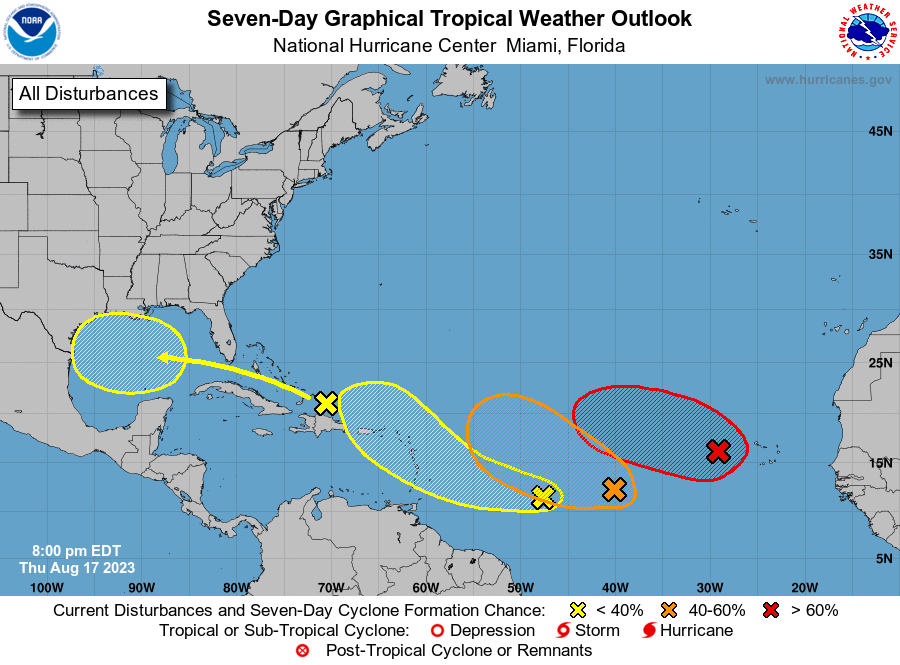
Teban54 wrote:August 17:
https://i.postimg.cc/wTvW4b9z/two-atl-7d0.png
It's very unlikely to see all 4 develop, and most probably won't get very strong. But still, looks like the switch had been flipped.
That or.........the mid-Atlantic ridge just violently spewed the entire world supply of Skittles
7 likes
Andy D
(For official information, please refer to the NHC and NWS products.)
(For official information, please refer to the NHC and NWS products.)
Re: 2023 Indicators (SST, SAL, MSLP, Wind shear, Steering, Instability) and Day 16+ Models
Definitely one of the more odd hurricane seasons that I can remember. I don't think I have ever seen more debate between pro mets on whether or not the season will be above average or below average. Also the models seem to have zero consistency and are having issues even accurately resolving what is going to happen within the next 5 days.
0 likes


Re: 2023 Indicators (SST, SAL, MSLP, Wind shear, Steering, Instability) and Day 16+ Models
chaser1 wrote:Teban54 wrote:August 17:
https://i.postimg.cc/wTvW4b9z/two-atl-7d0.png
It's very unlikely to see all 4 develop, and most probably won't get very strong. But still, looks like the switch had been flipped.
That or.........the mid-Atlantic ridge just violently spewed the entire world supply of Skittles
I don’t expect any of the areas to develop to be honest…Atlantic looks about as unfavorable as you can get this time of year with all the shear and dry air.
0 likes
-
Category5Kaiju

- Category 5
- Posts: 4347
- Joined: Thu Dec 24, 2020 12:45 pm
- Location: Seattle during the summer, Phoenix during the winter
Re: 2023 Indicators (SST, SAL, MSLP, Wind shear, Steering, Instability) and Day 16+ Models
So I took a break from tracking the tropics for several days. And right now, all I have to say is, "WHOA!" 

2 likes
Unless explicitly stated, all information in my posts is based on my own opinions and observations. Tropical storms and hurricanes can be extremely dangerous. Refer to an accredited weather research agency or meteorologist if you need to make serious decisions regarding an approaching storm.

Re: 2023 Indicators (SST, SAL, MSLP, Wind shear, Steering, Instability) and Day 16+ Models
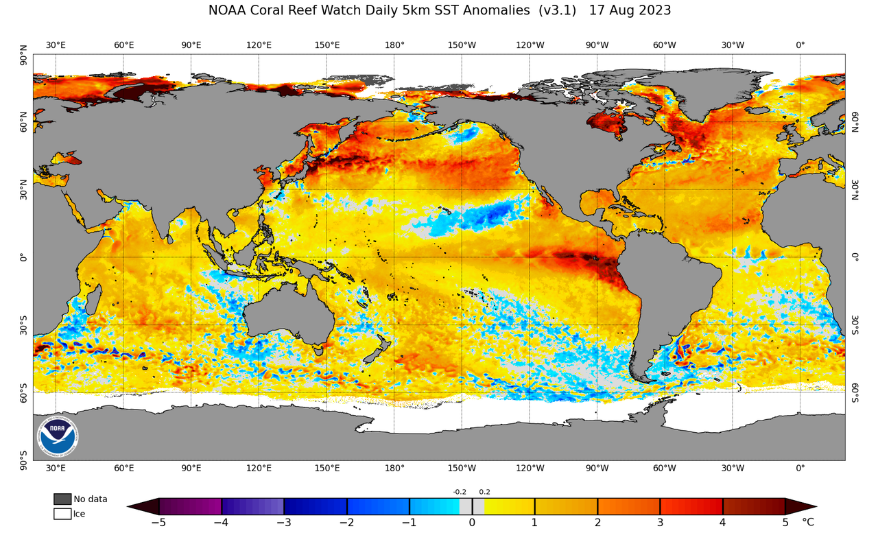
First 15 days in August shear anomaly across the Atlantic in particular across the Caribbean has no comparison to the last three El Ninos.


10 likes
-
CyclonicFury

- Category 5
- Posts: 2038
- Age: 27
- Joined: Sun Jul 02, 2017 12:32 pm
- Location: NC
- Contact:
Re: 2023 Indicators (SST, SAL, MSLP, Wind shear, Steering, Instability) and Day 16+ Models
NDG wrote:First 15 days in August shear anomaly across the Atlantic in particular across the Caribbean has no comparison to the last three El Ninos.
https://i.imgur.com/pB3DrbX.gif
https://i.imgur.com/Tsh0DNj.gif
https://i.imgur.com/4JKqTDm.gif
https://i.imgur.com/pTvFUdV.gif
Indeed, averaged over the entire season so far shear has been much lower in the Atlantic tropics than your typical Niño. Near the Lesser Antilles and eastern Caribbean shear has actually been well below average. Shear has been above average in the western Caribbean though.

Going to be interesting to see how the upcoming 2 weeks go. While many model runs aren't showing anything strong yet, this is normal for models as the peak period begins. The thermodynamics in the MDR appear to be becoming more conducive as well.
5 likes
NCSU B.S. in Meteorology Class of 2021. Tropical weather blogger at http://www.cyclonicfury.com. My forecasts and thoughts are NOT official, for official forecasts please consult the National Hurricane Center.
-
Category5Kaiju
- Category 5
- Posts: 4347
- Joined: Thu Dec 24, 2020 12:45 pm
- Location: Seattle during the summer, Phoenix during the winter
Re: 2023 Indicators (SST, SAL, MSLP, Wind shear, Steering, Instability) and Day 16+ Models
WiscoWx02 wrote:chaser1 wrote:Teban54 wrote:August 17:
https://i.postimg.cc/wTvW4b9z/two-atl-7d0.png
It's very unlikely to see all 4 develop, and most probably won't get very strong. But still, looks like the switch had been flipped.
That or.........the mid-Atlantic ridge just violently spewed the entire world supply of Skittles
I don’t expect any of the areas to develop to be honest…Atlantic looks about as unfavorable as you can get this time of year with all the shear and dry air.
Well, the easternmost MDR system is now red, and the area just southeast of the GA and the potential Gulf system have some pretty solid model support. If models didn't think the shear and dry air would really let up, then we would likely see something like we did in 2022 with crickets. Clearly that isn't exactly the case.
0 likes
Unless explicitly stated, all information in my posts is based on my own opinions and observations. Tropical storms and hurricanes can be extremely dangerous. Refer to an accredited weather research agency or meteorologist if you need to make serious decisions regarding an approaching storm.

Re: 2023 Indicators (SST, SAL, MSLP, Wind shear, Steering, Instability) and Day 16+ Models
I’m honestly a little skeptical we’ll see more than 1 NS out of the quartet of AOIs. Maybe we get a weak NS in the MDR or a brief TS in the Gulf, but not much else…yet.
0 likes
Irene '11 Sandy '12 Hermine '16 5/15/2018 Derecho Fay '20 Isaias '20 Elsa '21 Henri '21 Ida '21
I am only a meteorology enthusiast who knows a decent amount about tropical cyclones. Look to the professional mets, the NHC, or your local weather office for the best information.
I am only a meteorology enthusiast who knows a decent amount about tropical cyclones. Look to the professional mets, the NHC, or your local weather office for the best information.
-
ScottNAtlanta
- Category 5
- Posts: 2535
- Joined: Sat May 25, 2013 3:11 pm
- Location: Atlanta, GA
Re: 2023 Indicators (SST, SAL, MSLP, Wind shear, Steering, Instability) and Day 16+ Models
IcyTundra wrote:Definitely one of the more odd hurricane seasons that I can remember. I don't think I have ever seen more debate between pro mets on whether or not the season will be above average or below average..
Let me make that a little more specific...debate in MID AUGUST
0 likes
The posts in this forum are NOT official forecast and should not be used as such. They are just the opinion of the poster and may or may not be backed by sound meteorological data. They are NOT endorsed by any professional institution or storm2k.org. For official information, please refer to the NHC and NWS products.

Re: 2023 Indicators (SST, SAL, MSLP, Wind shear, Steering, Instability) and Day 16+ Models
CyclonicFury wrote:NDG wrote:First 15 days in August shear anomaly across the Atlantic in particular across the Caribbean has no comparison to the last three El Ninos.
https://i.imgur.com/pB3DrbX.gif
https://i.imgur.com/Tsh0DNj.gif
https://i.imgur.com/4JKqTDm.gif
https://i.imgur.com/pTvFUdV.gif
Indeed, averaged over the entire season so far shear has been much lower in the Atlantic tropics than your typical Niño. Near the Lesser Antilles and eastern Caribbean shear has actually been well below average. Shear has been above average in the western Caribbean though.
https://i.imgur.io/ZHq3tir_d.webp?maxwidth=640&shape=thumb&fidelity=medium
Going to be interesting to see how the upcoming 2 weeks go. While many model runs aren't showing anything strong yet, this is normal for models as the peak period begins. The thermodynamics in the MDR appear to be becoming more conducive as well.
I think the lower than average shear could be due to the heat in both oceans. The heat and trade winds are intertwined, usually strong trade winds will cool the ocean down and weak will warm them up. With both oceans been unusually warm the temperature differential isn't there to help drive the trade winds so the trade winds are slack and the shear is weaker than usual along with other factors like the jet stream been pushed more north etc.
3 likes
-
CyclonicFury
- Category 5
- Posts: 2038
- Age: 27
- Joined: Sun Jul 02, 2017 12:32 pm
- Location: NC
- Contact:
Re: 2023 Indicators (SST, SAL, MSLP, Wind shear, Steering, Instability) and Day 16+ Models
Typical Andy Hazelton. I don't know how a pro met could season cancel so much when we have so many signals across the basin. 
https://twitter.com/AndyHazelton/status/1692627920169140492
This would be so incredibly unlikely that every current AOI would have to bust, plus the CAG-like system, plus all future waves for the next 13 days.
https://twitter.com/AndyHazelton/status/1692627920169140492
This would be so incredibly unlikely that every current AOI would have to bust, plus the CAG-like system, plus all future waves for the next 13 days.
6 likes
NCSU B.S. in Meteorology Class of 2021. Tropical weather blogger at http://www.cyclonicfury.com. My forecasts and thoughts are NOT official, for official forecasts please consult the National Hurricane Center.
Re: 2023 Indicators (SST, SAL, MSLP, Wind shear, Steering, Instability) and Day 16+ Models
CyclonicFury wrote:Typical Andy Hazelton. I don't know how a pro met could season cancel so much when we have so many signals across the basin.
https://twitter.com/AndyHazelton/status/1692627920169140492?s=20
This would be so incredibly unlikely that every current AOI would have to bust, plus the CAG-like system, plus all future waves for the next 13 days.
I get that he thinks el nino is going to dominate the atlantic basin but this is definently downcasting and just a ridiculous statement.
2 likes
-
gatorcane

- S2K Supporter

- Posts: 23708
- Age: 48
- Joined: Sun Mar 13, 2005 3:54 pm
- Location: Boca Raton, FL
Re: 2023 Indicators (SST, SAL, MSLP, Wind shear, Steering, Instability) and Day 16+ Models
NDG wrote:First 15 days in August shear anomaly across the Atlantic in particular across the Caribbean has no comparison to the last three El Ninos.
https://i.imgur.com/pB3DrbX.gif
https://i.imgur.com/Tsh0DNj.gif
https://i.imgur.com/4JKqTDm.gif
https://i.imgur.com/pTvFUdV.gif
Maybe not yet but I think there is a good possibility that we will start seeing more of the typical El Niño shear especially starting around a month from now and into October as the El Niño continues to gain strength. The SSTs across the EPAC are at much higher anomalies than over on the Atlantic side so you would think the EPAC wins out when looking at anything significant forming across the Caribbean and possibly the Gulf. Plus the El Niño is already indirectly capping the Atlantic so far due to all of the EPAC activity it is creating.
0 likes

Re: 2023 Indicators (SST, SAL, MSLP, Wind shear, Steering, Instability) and Day 16+ Models
I agree there is a strong possibility El Nino keeps this season from going hyperactive. I'm pretty sure the Atlantic will put up a strong fight though. The Gulf is metaphorically on fire right now. It's roughly 1C warmer than it's counterpart in the EPac. It's hard to imagine the record breaking warmth not forcing a good deal of upward motion and promoting storms.gatorcane wrote:NDG wrote:First 15 days in August shear anomaly across the Atlantic in particular across the Caribbean has no comparison to the last three El Ninos.
https://i.imgur.com/pB3DrbX.gif
https://i.imgur.com/Tsh0DNj.gif
https://i.imgur.com/4JKqTDm.gif
https://i.imgur.com/pTvFUdV.gif
Maybe not yet but I think there is a good possibility that we will start seeing more of the typical El Niño shear especially starting around a month from now and into October as the El Niño continues to gain strength. The SSTs across the EPAC are at much higher anomalies than over on the Atlantic side so you would think the EPAC wins out when looking at anything significant forming across the Caribbean and possibly the Gulf. Plus the El Niño is already indirectly capping the Atlantic so far due to all of the EPAC activity it is creating.


2 likes
Re: 2023 Indicators (SST, SAL, MSLP, Wind shear, Steering, Instability) and Day 16+ Models
IcyTundra wrote:CyclonicFury wrote:Typical Andy Hazelton. I don't know how a pro met could season cancel so much when we have so many signals across the basin.
https://twitter.com/AndyHazelton/status/1692627920169140492?s=20
This would be so incredibly unlikely that every current AOI would have to bust, plus the CAG-like system, plus all future waves for the next 13 days.
I get that he thinks el nino is going to dominate the atlantic basin but this is definently downcasting and just a ridiculous statement.
I don’t think it’s a ridiculous statement at all. Think it’s quite plausible we go another August without a named storm. Conditions are just not good out there and I don’t for see that changing even as we head through peak season. Dry air will let up and should allow some development in the cracks in the wall of shear that will only become more prevalent as the season continues thanks to El Nino and the relentless parade of TUTT’s that are almost sure to come. I’m not saying no storms this season or season canceling but I definitely think those above average season outlooks are out the window. Below average is the most likely scenario imo based on what we have in front of us. Of course everyone interprets signals differently, just sharing my view point. If you look at the MJO graph on the CPC sight you can clearly see El Nino coupling with the atmosphere in the last month. The MJO was very progressive until mid July then it anchored itself in Phase 7-8 and has been there ever since. Rising air has also been over the Atlantic since the beginning of the month as someone else alluded to earlier in the discussion yet shear seems to have actually increased out there as we head through the month. Just what I see.
1 likes
-
weeniepatrol

- Category 5
- Posts: 1345
- Joined: Sat Aug 22, 2020 5:30 pm
- Location: WA State
Re: 2023 Indicators (SST, SAL, MSLP, Wind shear, Steering, Instability) and Day 16+ Models
CyclonicFury wrote:Typical Andy Hazelton. I don't know how a pro met could season cancel so much when we have so many signals across the basin.
https://twitter.com/AndyHazelton/status/1692627920169140492?s=20
This would be so incredibly unlikely that every current AOI would have to bust, plus the CAG-like system, plus all future waves for the next 13 days.
oh, dear... lol
1 likes
Re: 2023 Indicators (SST, SAL, MSLP, Wind shear, Steering, Instability) and Day 16+ Models
IcyTundra wrote:CyclonicFury wrote:Typical Andy Hazelton. I don't know how a pro met could season cancel so much when we have so many signals across the basin.
https://twitter.com/AndyHazelton/status/1692627920169140492?s=20
This would be so incredibly unlikely that every current AOI would have to bust, plus the CAG-like system, plus all future waves for the next 13 days.
I get that he thinks el nino is going to dominate the atlantic basin but this is definently downcasting and just a ridiculous statement.
He just bought a house this year, so his wishful thinking is that El Nino will dominate the Atlantic
2 likes
Re: 2023 Indicators (SST, SAL, MSLP, Wind shear, Steering, Instability) and Day 16+ Models
WiscoWx02 wrote:IcyTundra wrote:CyclonicFury wrote:Typical Andy Hazelton. I don't know how a pro met could season cancel so much when we have so many signals across the basin.
https://twitter.com/AndyHazelton/status/1692627920169140492?s=20
This would be so incredibly unlikely that every current AOI would have to bust, plus the CAG-like system, plus all future waves for the next 13 days.
I get that he thinks el nino is going to dominate the atlantic basin but this is definently downcasting and just a ridiculous statement.
I don’t think it’s a ridiculous statement at all. Think it’s quite plausible we go another August without a named storm. Conditions are just not good out there and I don’t for see that changing even as we head through peak season. Dry air will let up and should allow some development in the cracks in the wall of shear that will only become more prevalent as the season continues thanks to El Nino and the relentless parade of TUTT’s that are almost sure to come. I’m not saying no storms this season or season canceling but I definitely think those above average season outlooks are out the window. Below average is the most likely scenario imo based on what we have in front of us. Of course everyone interprets signals differently, just sharing my view point. If you look at the MJO graph on the CPC sight you can clearly see El Nino coupling with the atmosphere in the last month. The MJO was very progressive until mid July then it anchored itself in Phase 7-8 and has been there ever since. Rising air has also been over the Atlantic since the beginning of the month as someone else alluded to earlier in the discussion yet shear seems to have actually increased out there as we head through the month. Just what I see.
The tropical wave about to enter the gulf has a good chance of being a TS before it moves into South Texas.
1 likes

Re: 2023 Indicators (SST, SAL, MSLP, Wind shear, Steering, Instability) and Day 16+ Models
WiscoWx02 wrote:IcyTundra wrote:CyclonicFury wrote:Typical Andy Hazelton. I don't know how a pro met could season cancel so much when we have so many signals across the basin.
https://twitter.com/AndyHazelton/status/1692627920169140492?s=20
This would be so incredibly unlikely that every current AOI would have to bust, plus the CAG-like system, plus all future waves for the next 13 days.
I get that he thinks el nino is going to dominate the atlantic basin but this is definently downcasting and just a ridiculous statement.
I don’t think it’s a ridiculous statement at all. Think it’s quite plausible we go another August without a named storm. Conditions are just not good out there and I don’t for see that changing even as we head through peak season. Dry air will let up and should allow some development in the cracks in the wall of shear that will only become more prevalent as the season continues thanks to El Nino and the relentless parade of TUTT’s that are almost sure to come. I’m not saying no storms this season or season canceling but I definitely think those above average season outlooks are out the window. Below average is the most likely scenario imo based on what we have in front of us. Of course everyone interprets signals differently, just sharing my view point. If you look at the MJO graph on the CPC sight you can clearly see El Nino coupling with the atmosphere in the last month. The MJO was very progressive until mid July then it anchored itself in Phase 7-8 and has been there ever since. Rising air has also been over the Atlantic since the beginning of the month as someone else alluded to earlier in the discussion yet shear seems to have actually increased out there as we head through the month. Just what I see.
People said the exact same thing after Earl became post-tropical last year, and that's after an actual storm-free August and Earl massively busting. We know how that turned out.
Calling for another storm-free August when we have 4 active AOIs - one of which (99L) has been claimed by weather enthusiasts to look like a TD already - is indeed ridiculous.
1 likes
TC naming lists: retirements and intensity
Most aggressive Advisory #1's in North Atlantic (cr. kevin for starting the list)
Most aggressive Advisory #1's in North Atlantic (cr. kevin for starting the list)
Who is online
Users browsing this forum: bird and 144 guests