2023 Global Model Runs Discussion (Out thru day 16)

This is the general tropical discussion area. Anyone can take their shot at predicting a storms path.

Moderator: S2k Moderators

Forum rules

The posts in this forum are NOT official forecasts and should not be used as such. They are just the opinion of the poster and may or may not be backed by sound meteorological data. They are NOT endorsed by any professional institution or STORM2K. For official information, please refer to products from the National Hurricane Center and National Weather Service.

Help Support Storm2K
Message
Author
User avatar
SFLcane
S2K Supporter
S2K Supporter
Posts: 10162
Age: 47
Joined: Sat Jun 05, 2010 1:44 pm
Location: Lake Worth Florida

Re: RE: Re: 2023 Global Model Runs Discussion (Out thru day 16)

#1161 Postby SFLcane » Sun Aug 20, 2023 11:01 am

jlauderdal wrote:
SFLcane wrote:Tc outbreak incoming.. these waves in particular are interesting

https://i.postimg.cc/gJgWfm7m/IMG-1350.gif

https://i.postimg.cc/s2Vf862P/IMG-1352.gif
Its been active in se fla, yesterday was a bust but over achieving since midnite


Was talking with Robert Garcia yesterday senior met wfo
SFL and yup the wave was unimpressive and stayed further south then initially thought. Cfs did great picking up the current activity
0 likes   

User avatar
aspen
Category 5
Category 5
Posts: 8812
Joined: Sat Oct 12, 2019 7:10 pm
Location: Connecticut, USA

Re: 2023 Global Model Runs Discussion (Out thru day 16)

#1162 Postby aspen » Sun Aug 20, 2023 11:31 am

12z CMC regenerates Emily in the subtropics. While it doesn’t care much for the current lemon, it gets a MDR runner out of the wave behind it.
0 likes   
Irene '11 Sandy '12 Hermine '16 5/15/2018 Derecho Fay '20 Isaias '20 Elsa '21 Henri '21 Ida '21

I am only a meteorology enthusiast who knows a decent amount about tropical cyclones. Look to the professional mets, the NHC, or your local weather office for the best information.

User avatar
Steve
S2K Supporter
S2K Supporter
Posts: 9591
Joined: Sat Apr 05, 2003 11:41 pm
Location: Not a state-caster

Re: 2023 Global Model Runs Discussion (Out thru day 16)

#1163 Postby Steve » Sun Aug 20, 2023 12:20 pm

ICON showing a crossover type weakness with lowest pressure in the Gulf. This would be valid 7pm next week Sunday. 0Z Euro had a hint near the Yucatán but so far those are the ones kind of showing the Gulf as being a place to watch for a possible system.

https://www.tropicaltidbits.com/analysi ... 012&fh=180

CMC 12z wants something to come up as well but moves it out across south Florida.

https://www.tropicaltidbits.com/analysi ... 012&fh=240
1 likes   

User avatar
gatorcane
S2K Supporter
S2K Supporter
Posts: 23689
Age: 47
Joined: Sun Mar 13, 2005 3:54 pm
Location: Boca Raton, FL

Re: 2023 Global Model Runs Discussion (Out thru day 16)

#1164 Postby gatorcane » Sun Aug 20, 2023 1:59 pm

12Z Euro with something no other model has (outside the CMC which is weak) into the Eastern Gulf and Florida. Since it is an outlier, going with phantom development:

Image
3 likes   

IcyTundra
Category 5
Category 5
Posts: 1205
Joined: Mon Jun 07, 2021 9:32 pm
Location: Dickinson, Texas

Re: 2023 Global Model Runs Discussion (Out thru day 16)

#1165 Postby IcyTundra » Sun Aug 20, 2023 2:03 pm

gatorcane wrote:12Z Euro with something no other model has into the Eastern Gulf and Florida. Since it is an outlier, going with phantom development:

https://i.postimg.cc/pVJzwrxD/ec-fast-mslpa-Norm-watl-fh144-240.gif


Pretty sure that is the EPAC to Atlantic crossover system that it has been showing off and on for the past few days. The GFS also has the same feature in the EPAC but it is a lot stronger and it moves northward over Central America and dissipates.
1 likes   

User avatar
Cpv17
Category 5
Category 5
Posts: 4917
Joined: Wed Dec 07, 2016 2:24 pm
Location: Wharton/El Campo, TX

Re: 2023 Global Model Runs Discussion (Out thru day 16)

#1166 Postby Cpv17 » Sun Aug 20, 2023 2:07 pm

IcyTundra wrote:
gatorcane wrote:12Z Euro with something no other model has into the Eastern Gulf and Florida. Since it is an outlier, going with phantom development:

https://i.postimg.cc/pVJzwrxD/ec-fast-mslpa-Norm-watl-fh144-240.gif


Pretty sure that is the EPAC to Atlantic crossover system that it has been showing off and on for the past few days. The GFS also has the same feature in the EPAC but it is a lot stronger and it moves northward over Central America and dissipates.


The ICON has it as well.
1 likes   

User avatar
Ivanhater
Storm2k Moderator
Storm2k Moderator
Posts: 11153
Age: 38
Joined: Fri Jul 01, 2005 8:25 am
Location: Pensacola

Re: 2023 Global Model Runs Discussion (Out thru day 16)

#1167 Postby Ivanhater » Sun Aug 20, 2023 2:47 pm

Cpv17 wrote:
IcyTundra wrote:
gatorcane wrote:12Z Euro with something no other model has into the Eastern Gulf and Florida. Since it is an outlier, going with phantom development:

https://i.postimg.cc/pVJzwrxD/ec-fast-mslpa-Norm-watl-fh144-240.gif


Pretty sure that is the EPAC to Atlantic crossover system that it has been showing off and on for the past few days. The GFS also has the same feature in the EPAC but it is a lot stronger and it moves northward over Central America and dissipates.


The ICON has it as well.


Cmc had this as well.
1 likes   
Michael

User avatar
SFLcane
S2K Supporter
S2K Supporter
Posts: 10162
Age: 47
Joined: Sat Jun 05, 2010 1:44 pm
Location: Lake Worth Florida

Re: 2023 Global Model Runs Discussion (Out thru day 16)

#1168 Postby SFLcane » Sun Aug 20, 2023 2:53 pm

gatorcane wrote:12Z Euro with something no other model has (outside the CMC which is weak) into the Eastern Gulf and Florida. Since it is an outlier, going with phantom development:

https://i.postimg.cc/pVJzwrxD/ec-fast-mslpa-Norm-watl-fh144-240.gif


Ecmwf an outlier? Phantom? Now your reaching Lol.

Next few weeks looks very active!

Image

Image
1 likes   

User avatar
MetroMike
Category 4
Category 4
Posts: 943
Joined: Sun Aug 29, 2004 8:13 pm
Location: Tampa Bay
Contact:

Re: 2023 Global Model Runs Discussion (Out thru day 16)

#1169 Postby MetroMike » Sun Aug 20, 2023 3:05 pm

In Joe Bastardi''s Sat summary he was eluding to something that could develop down there and head into the Gulf.
Guess he was picking up on something. See if it persists in further runs.
0 likes   

User avatar
SFLcane
S2K Supporter
S2K Supporter
Posts: 10162
Age: 47
Joined: Sat Jun 05, 2010 1:44 pm
Location: Lake Worth Florida

Re: 2023 Global Model Runs Discussion (Out thru day 16)

#1170 Postby SFLcane » Sun Aug 20, 2023 3:11 pm

Image
0 likes   

User avatar
Steve
S2K Supporter
S2K Supporter
Posts: 9591
Joined: Sat Apr 05, 2003 11:41 pm
Location: Not a state-caster

Re: 2023 Global Model Runs Discussion (Out thru day 16)

#1171 Postby Steve » Sun Aug 20, 2023 4:35 pm

gatorcane wrote:12Z Euro with something no other model has (outside the CMC which is weak) into the Eastern Gulf and Florida. Since it is an outlier, going with phantom development:

https://i.postimg.cc/pVJzwrxD/ec-fast-mslpa-Norm-watl-fh144-240.gif


If it happens it will autocorrect westward. That’s not to say it’s a SE Louisiana hit or anything. It would probably adjust for late August where storms don’t usually head off NE coming up until maybe landfall.
0 likes   

Texoz
Tropical Depression
Tropical Depression
Posts: 52
Joined: Mon Feb 22, 2021 6:55 pm

Re: 2023 Global Model Runs Discussion (Out thru day 16)

#1172 Postby Texoz » Sun Aug 20, 2023 4:50 pm


High pressure death ridge wins again? re: tropical storm going into northern Mexico instead of Texas.
0 likes   

User avatar
gatorcane
S2K Supporter
S2K Supporter
Posts: 23689
Age: 47
Joined: Sun Mar 13, 2005 3:54 pm
Location: Boca Raton, FL

Re: 2023 Global Model Runs Discussion (Out thru day 16)

#1173 Postby gatorcane » Sun Aug 20, 2023 5:40 pm

The GFS doesn’t have the Euro OP Eastern Gulf hurricane and the EPS looks unimpressive so that Euro OP run showing a hurricane looks suspect to me. Lots of activity all heading towards the North Atlantic according to the GFS. Bermuda. Nova Scotia, and Newfoundland should pay attention to Franklin and perhaps some of the subsequent systems:

Image
0 likes   

User avatar
ronjon
Category 5
Category 5
Posts: 4811
Joined: Fri Aug 19, 2005 5:17 pm
Location: Hernando Beach, FL

Re: 2023 Global Model Runs Discussion (Out thru day 16)

#1174 Postby ronjon » Sun Aug 20, 2023 8:24 pm

18z GFS does however have a weak crossover low (1007 mb) similar to Euro. It just keeps it weak and shunts it NE south of Florida. Something to watch the models over the coming days as now 4 models show a cross over disturbance: GFS, Euro, CMC and ICON.
0 likes   

User avatar
SFLcane
S2K Supporter
S2K Supporter
Posts: 10162
Age: 47
Joined: Sat Jun 05, 2010 1:44 pm
Location: Lake Worth Florida

Re: 2023 Global Model Runs Discussion (Out thru day 16)

#1175 Postby SFLcane » Sun Aug 20, 2023 8:34 pm

gatorcane wrote:The GFS doesn’t have the Euro OP Eastern Gulf hurricane and the EPS looks unimpressive so that Euro OP run showing a hurricane looks suspect to me. Lots of activity all heading towards the North Atlantic according to the GFS. Bermuda. Nova Scotia, and Newfoundland should pay attention to Franklin and perhaps some of the subsequent systems:

https://i.postimg.cc/1zkqg98B/gfs-mslp-wind-atl-fh0-192.gif


Everything has looked suspect to you even the ongoing tc outbreak as you have stated numerous times do to high wind shear across the entire Atlantic. Despite the hostile environment things have really ramped up and goes to show you how quickly things can change this time of the year.

Image


The next 2/3 weeks should get even busier heading into the first week of September.

Image
8 likes   

User avatar
blp
Category 5
Category 5
Posts: 2840
Age: 46
Joined: Thu Sep 09, 2004 7:51 pm
Location: Miami, FL
Contact:

Re: 2023 Global Model Runs Discussion (Out thru day 16)

#1176 Postby blp » Sun Aug 20, 2023 11:46 pm

Oh my! now it's Red everywhere. 3 storms with Gert. Never seen anything like it. The downcasters have awaken the Atlantic. :eek:

Image
6 likes   
The following post is NOT an official forecast and should not be used as such. It is just the opinion of the poster and may or may not be backed by sound meteorological data. It is NOT endorsed by any professional institution including storm2k.org For Official Information please refer to the NHC and NWS products.

mantis83
Tropical Storm
Tropical Storm
Posts: 198
Joined: Fri Dec 05, 2003 4:47 pm

Re: 2023 Global Model Runs Discussion (Out thru day 16)

#1177 Postby mantis83 » Mon Aug 21, 2023 2:18 am

blp wrote:Oh my! now it's Red everywhere. 3 storms with Gert. Never seen anything like it. The downcasters have awaken the Atlantic. :eek:

https://i.ibb.co/8ddYThH/two-atl-7d0.png

lots of ace with little impact to any land, the best kind of hurricane season! :lol:
1 likes   

ChrisH-UK
Category 2
Category 2
Posts: 611
Joined: Sat May 29, 2021 8:22 am

Re: 2023 Global Model Runs Discussion (Out thru day 16)

#1178 Postby ChrisH-UK » Mon Aug 21, 2023 6:37 am

blp wrote:Oh my! now it's Red everywhere. 3 storms with Gert. Never seen anything like it. The downcasters have awaken the Atlantic. :eek:

https://i.ibb.co/8ddYThH/two-atl-7d0.png


Is this 2020. that was the last time we had 5 named storms in the Atlantic
2 likes   

User avatar
kevin
Category 5
Category 5
Posts: 2554
Age: 26
Joined: Wed Aug 28, 2019 4:35 am

Re: 2023 Global Model Runs Discussion (Out thru day 16)

#1179 Postby kevin » Mon Aug 21, 2023 6:54 am

06z GFS


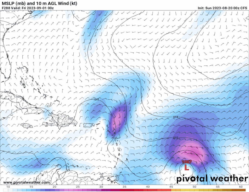
*Gert falls apart within 24 hours.
*Emily hangs on quite a while (~120 hrs) as a TD/TS, peaks at 1002 mb.
*Franklin landfalls at 48 hours with a pressure of 993 mb. Afterwards it bombs out into the second hurricane of the season with a peak of 968 mb at 150 hours. (Potentially extratropical) remnants of Franklin could impact Newfoundland in the long term (~200 hrs).
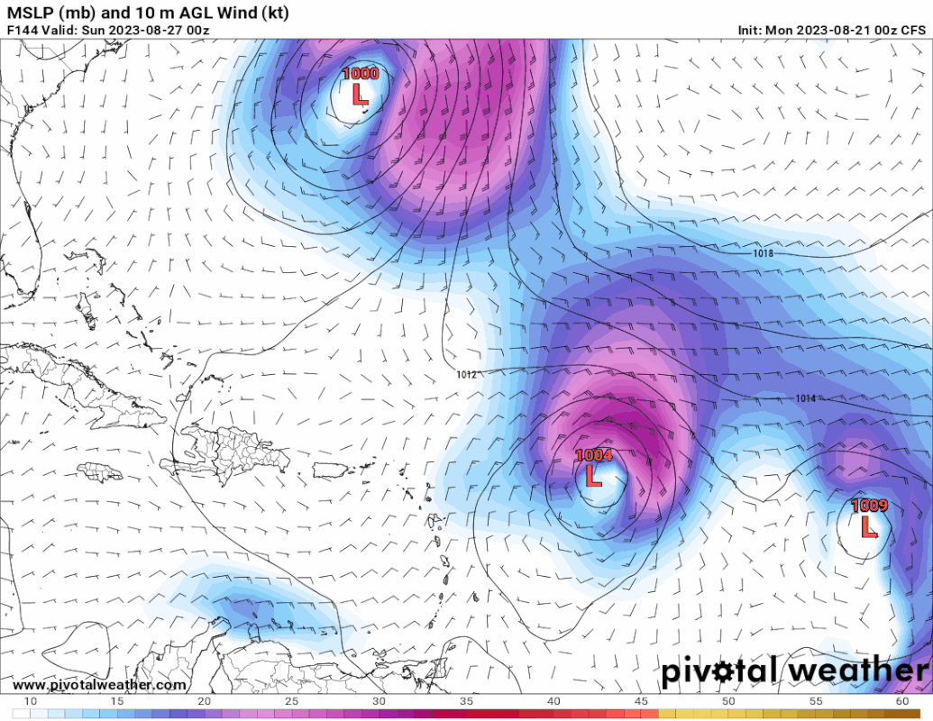
*91L becomes TS Harold and makes landfall in southern Texas at 30 hours with a pressure of 1000 mb.
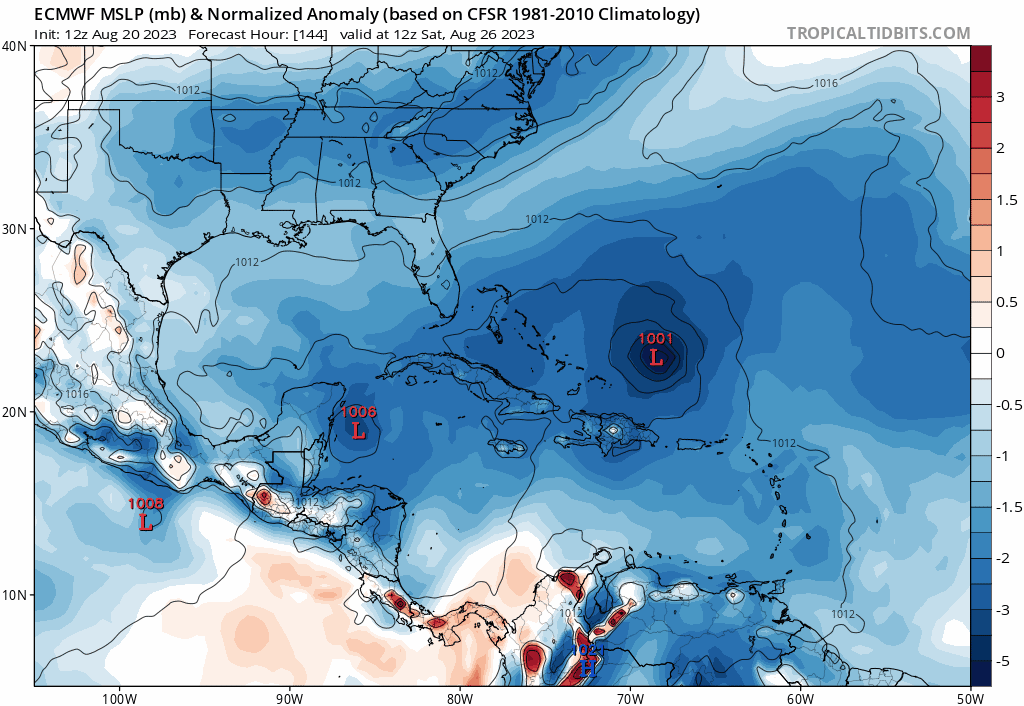
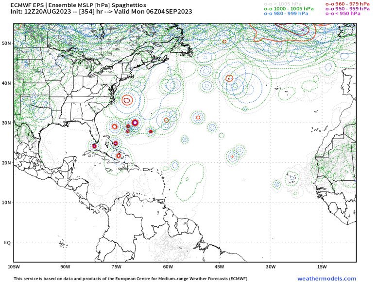
*92L becomes a a big ACE hurricane (probably Idalia), peaking at 957 mb and remaining a MH until it becomes ET.

Other things this run
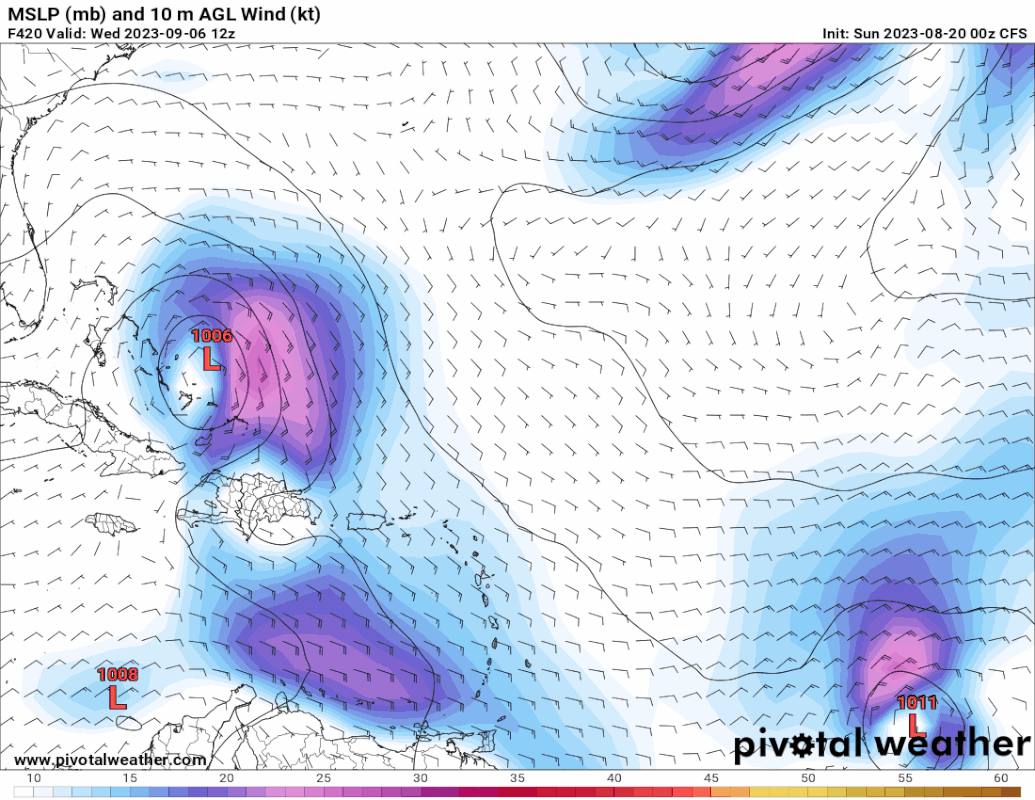
*TD/TS (1004 mb) into western Florida at 234 hours.
*A new CV TD/TS about to form at the end of the run.

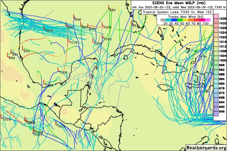
While it it unwise to take long-term model runs as fact, runs like this indicate that we could already be at Jose or Katia in the first week of September with 5 or maybe even 6 TCs in August. Just to illustrate that the Atlantic has really woken up.
8 likes   

User avatar
SFLcane
S2K Supporter
S2K Supporter
Posts: 10162
Age: 47
Joined: Sat Jun 05, 2010 1:44 pm
Location: Lake Worth Florida

Re: 2023 Global Model Runs Discussion (Out thru day 16)

#1180 Postby SFLcane » Mon Aug 21, 2023 8:33 am

:eek:

Image
2 likes   


Return to “Talkin' Tropics”

Who is online

Users browsing this forum: Google Adsense [Bot] and 179 guests