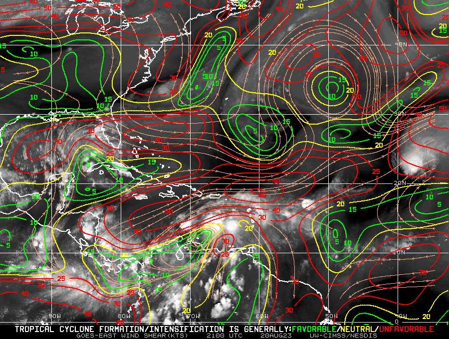
ATL: HAROLD - Remnants - Discussion

Moderator: S2k Moderators

Message
Author
User avatar
tropicwatch
Category 5
Category 5
Posts: 3364
Age: 61
Joined: Sat Jun 02, 2007 10:01 am
Location: Panama City Florida
Contact:

Re: ATL: INVEST 91L - Discussion

#41 Postby tropicwatch » Sun Aug 20, 2023 6:59 pm

zzzh wrote:
tropicwatch wrote:Currently encountering 25 to 30kt wind shear.

No, wind shear should be around 10kt.


Image
2 likes   
Tropicwatch


Agnes 72', Eloise 75, Elena 85', Kate 85', Charley 86', Florence 88', Beryl 94', Dean 95', Erin 95', Opal 95', Earl 98', Georges 98', Ivan 2004', Arlene 2005', Dennis 2005', Ida 2009' Debby 2012' Irma 2017' Michael 2018'

User avatar
lrak
S2K Supporter
S2K Supporter
Posts: 1770
Age: 58
Joined: Thu Jun 21, 2007 2:48 pm
Location: Corpus Christi, TX

Re: ATL: INVEST 91L - Discussion: TWO up to 70%

#42 Postby lrak » Sun Aug 20, 2023 6:59 pm

Need that rain, CCTX will be dry slotted as usual...lol
0 likes   
AKA karl

Also
Personal Forecast Disclaimer:
My posts on this forum are NOT official forecast and should not be used as such. My posts are my basic observations and are definitely not backed by any "well some" meteorological knowledge. For official information, please refer to the NHC and NWS products.

IcyTundra
Category 5
Category 5
Posts: 1205
Joined: Mon Jun 07, 2021 9:32 pm
Location: Dickinson, Texas

Re: ATL: INVEST 91L - Discussion

#43 Postby IcyTundra » Sun Aug 20, 2023 7:01 pm

galvestontx wrote:Well heading to Port Aransas tomorrow morning for a week vacation, will see how it goes lol.


That should be far enough up the coast to avoid the worst of the rainfall and gusty winds. Probably just some rain on Tuesday for you.
0 likes   

User avatar
wxman57
Moderator-Pro Met
Moderator-Pro Met
Posts: 22951
Age: 67
Joined: Sat Jun 21, 2003 8:06 pm
Location: Houston, TX (southwest)

Re: ATL: INVEST 91L - Discussion: TWO up to 70%

#44 Postby wxman57 » Sun Aug 20, 2023 7:28 pm

Seems like someone here said NHC would be up to 70% by Sunday. It'll be 90% tomorrow. Question is, do they start PTC advisories now? There is a fair chance that it may have a small area of TS wind at landfall, which would require a TS watch as of about 10am this morning. Hmm...

I have it moving ashore just north of Brownsville as a 30 kt TD around 10am Tuesday. Could be a small area of TS wind. Wind won't be any issue for TX. Rain will be welcome. Come up here to Houston, 91L!! Temperature here in SW Houston has really cooled off now. Only 101.1. Was 106 earlier. Almost makes me want to see a cold front. Almost.
8 likes   

User avatar
wxman57
Moderator-Pro Met
Moderator-Pro Met
Posts: 22951
Age: 67
Joined: Sat Jun 21, 2003 8:06 pm
Location: Houston, TX (southwest)

Re: ATL: INVEST 91L - Discussion

#45 Postby wxman57 » Sun Aug 20, 2023 7:30 pm

galvestontx wrote:Well heading to Port Aransas tomorrow morning for a week vacation, will see how it goes lol.


You'll get a couple inches of rain Tuesday then the heat returns with a vengeance Wednesday.
1 likes   

User avatar
Tireman4
S2K Supporter
S2K Supporter
Posts: 5851
Age: 59
Joined: Fri Jun 30, 2006 1:08 pm
Location: Humble, Texas
Contact:

Re: ATL: INVEST 91L - Discussion: TWO up to 70%

#46 Postby Tireman4 » Sun Aug 20, 2023 7:31 pm

wxman57 wrote:Seems like someone here said NHC would be up to 70% by Sunday. It'll be 90% tomorrow. Question is, do they start PTC advisories now? There is a fair chance that it may have a small area of TS wind at landfall, which would require a TS watch as of about 10am this morning. Hmm...

I have it moving ashore just north of Brownsville as a 30 kt TD around 10am Tuesday. Could be a small area of TS wind. Wind won't be any issue for TX. Rain will be welcome. Come up here to Houston, 91L!! Temperature here in SW Houston has really cooled off now. Only 101.1. Was 106 earlier. Almost makes me want to see a cold front. Almost.


Oh sir, you are just a hoot. We are beyond baked and you are rubbing it in. My gracious lol
0 likes   

USTropics
Category 5
Category 5
Posts: 2635
Joined: Sun Aug 12, 2007 3:45 am
Location: Florida State University

Re: ATL: INVEST 91L - Discussion

#47 Postby USTropics » Sun Aug 20, 2023 7:39 pm

zzzh wrote:
tropicwatch wrote:Currently encountering 25 to 30kt wind shear.

No, wind shear should be around 10kt.


Shear is not detrimental to development, flow is a bit brisk in the mid-levels up to about 500mb (due to the stout pressure gradient difference) but there is no directional displacement:
Image
Image

As others have stated, even a stronger system will not be able to budge this ridge and move more north. There is off-the-chart high pressure over the central US currently:
Image

The biggest detriment to development is the still sprawling/banding nature of the system and the time it has over the GOM (30-36 hours max).
Last edited by USTropics on Sun Aug 20, 2023 7:40 pm, edited 1 time in total.
4 likes   

Wampadawg
Tropical Storm
Tropical Storm
Posts: 235
Joined: Wed Oct 14, 2020 10:28 am
Location: South Texas

Re: ATL: INVEST 91L - Discussion: TWO up to 70%

#48 Postby Wampadawg » Sun Aug 20, 2023 7:39 pm

wxman57 wrote:Seems like someone here said NHC would be up to 70% by Sunday. It'll be 90% tomorrow. Question is, do they start PTC advisories now? There is a fair chance that it may have a small area of TS wind at landfall, which would require a TS watch as of about 10am this morning. Hmm...

I have it moving ashore just north of Brownsville as a 30 kt TD around 10am Tuesday. Could be a small area of TS wind. Wind won't be any issue for TX. Rain will be welcome. Come up here to Houston, 91L!! Temperature here in SW Houston has really cooled off now. Only 101.1. Was 106 earlier. Almost makes me want to see a cold front. Almost.

Yea Houston is not fun at all ,and I have the AC/Water bills to prove it, disappointing that Jabba the High ruined our party
0 likes   
Harvey,Hanna,Beta,Texas Winter storm2021,Nicholas,Beryl

User avatar
Nimbus
Category 5
Category 5
Posts: 5274
Joined: Mon Jul 19, 2004 10:54 am

Re: ATL: INVEST 91L - Discussion: TWO up to 70%

#49 Postby Nimbus » Sun Aug 20, 2023 7:39 pm

Wasn't very impressed with the wave as it came through Key West surface pressures bottomed near 29.88.
Noticed some low cloud rotation centered near 23.66 84.41 on the infrared which may be an illusion.

Upper low over Mexico is pulling moisture from Hillary around and might steer a developed circulation a little further north and feed it some moisture through the Yucatan Channel. Would need to see a big convection explosion to verify as well as model support next couple runs.
1 likes   

Tailgater33
Tropical Depression
Tropical Depression
Posts: 78
Joined: Thu Jun 02, 2022 9:15 am

Re: ATL: INVEST 91L - Discussion

#50 Postby Tailgater33 » Mon Aug 21, 2023 12:40 am

I’d be surprised if it makes land fall north of the border. Seems the most tightening is father South than what was expected even a day ago.
0 likes   

User avatar
Extratropical94
Professional-Met
Professional-Met
Posts: 3538
Age: 30
Joined: Wed Oct 20, 2010 6:36 am
Location: Hamburg, Germany
Contact:

Re: ATL: INVEST 91L - Discussion

#51 Postby Extratropical94 » Mon Aug 21, 2023 6:37 am

80/80 as of 8am, PTC designation incoming

Showers and thunderstorms are showing signs of organization
in association with a broad area of low pressure located over the
central Gulf of Mexico. Environmental conditions appear conducive
for development of this system, and a tropical depression or
tropical storm is likely to form before it reaches the western Gulf
of Mexico coastline on Tuesday. Interests in southern Texas and
northern Mexico should monitor the progress of this system as
tropical storm watches or warnings are likely to be issued later
today
.
* Formation chance through 48 hours...high...80 percent.
* Formation chance through 7 days...high...80 percent.
1 likes   
54° 11' 59'' N, 9° 9' 20'' E
Boomer Sooner!
Go Broncos! Go Cards! Go Niners!
- Daniel

User avatar
wxman57
Moderator-Pro Met
Moderator-Pro Met
Posts: 22951
Age: 67
Joined: Sat Jun 21, 2003 8:06 pm
Location: Houston, TX (southwest)

Re: ATL: INVEST 91L - Discussion

#52 Postby wxman57 » Mon Aug 21, 2023 6:53 am

It's about time NHC issues something. We've been issuing advisories for two days. Weak TS north of Brownsville tomorrow.
2 likes   

User avatar
cycloneye
Admin
Admin
Posts: 143867
Age: 68
Joined: Thu Oct 10, 2002 10:54 am
Location: San Juan, Puerto Rico

Re: ATL: INVEST 91L - Discussion

#53 Postby cycloneye » Mon Aug 21, 2023 8:03 am

AL, 91, 2023082112, , BEST, 0, 248N, 890W, 25, 1008, DB


Image
0 likes   
Visit the Caribbean-Central America Weather Thread where you can find at first post web cams,radars
and observations from Caribbean basin members Click Here

User avatar
Rgv20
S2K Supporter
S2K Supporter
Posts: 2466
Age: 38
Joined: Wed Jan 05, 2011 5:42 pm
Location: Edinburg/McAllen Tx

Re: ATL: INVEST 91L - Discussion

#54 Postby Rgv20 » Mon Aug 21, 2023 8:25 am

Saved Loop...First images of Visible Satellite.

Image
0 likes   
The following post is NOT an official forecast and should not be used as such. It is just the opinion of the poster and may or may not be backed by sound meteorological data. It is NOT endorsed by any professional institution including storm2k.org For Official Information please refer to the NHC and NWS products.

User avatar
Category5Kaiju
Category 5
Category 5
Posts: 4051
Joined: Thu Dec 24, 2020 12:45 pm
Location: Seattle

Re: ATL: INVEST 91L - Discussion

#55 Postby Category5Kaiju » Mon Aug 21, 2023 8:30 am

Interesting to note that this could become "Harold," which replaced a certain other H storm that impacted the same region 6 years ago
1 likes   
Unless explicitly stated, all info in my posts is based on my own opinions and observations. Tropical storms and hurricanes can be extremely dangerous. Do not think you can beat Mother Nature. Refer to an accredited weather research agency or meteorologist if you need to make serious decisions regarding an approaching storm.

User avatar
ScottNAtlanta
Category 5
Category 5
Posts: 2360
Joined: Sat May 25, 2013 3:11 pm
Location: Atlanta, GA

Re: ATL: INVEST 91L - Discussion

#56 Postby ScottNAtlanta » Mon Aug 21, 2023 8:37 am

wxman57 wrote:
galvestontx wrote:Well heading to Port Aransas tomorrow morning for a week vacation, will see how it goes lol.


You'll get a couple inches of rain Tuesday then the heat returns with a vengeance Wednesday.

Makes Cold Miser look like not so bad of a guy these days, huh
0 likes   
The posts in this forum are NOT official forecast and should not be used as such. They are just the opinion of the poster and may or may not be backed by sound meteorological data. They are NOT endorsed by any professional institution or storm2k.org. For official information, please refer to the NHC and NWS products.

User avatar
Steve
S2K Supporter
S2K Supporter
Posts: 9591
Joined: Sat Apr 05, 2003 11:41 pm
Location: Not a state-caster

Re: ATL: INVEST 91L - Discussion

#57 Postby Steve » Mon Aug 21, 2023 8:49 am

Taking shape down there in the Gulf without enough time to get really strong or anything.

https://www.tropicaltidbits.com/sat/sat ... t=vis_swir

Fair chance some up the Coast in Texas might see some brief passing showers as they are pretty close to here today.
https://radar.weather.gov/?settings=v1_ ... wiOjAuNn19
0 likes   

Subtrop
Category 2
Category 2
Posts: 654
Joined: Sun Feb 21, 2021 9:45 pm

Re: ATL: INVEST 09L - Discussion

#58 Postby Subtrop » Mon Aug 21, 2023 8:56 am

AL, 09, 2023082112, , BEST, 0, 248N, 890W, 25, 1008, DB, 34, NEQ, 0, 0, 0, 0, 1011, 120, 90, 0, 0, L, 0, , 0, 0, NINE, S, 0, , 0, 0, 0, 0, genesis-num, 019, TRANSITIONED, alB12023 to al092023,
1 likes   

User avatar
Rgv20
S2K Supporter
S2K Supporter
Posts: 2466
Age: 38
Joined: Wed Jan 05, 2011 5:42 pm
Location: Edinburg/McAllen Tx

Re: ATL: NINE - Potential Tropical Cyclone - Discussion

#59 Postby Rgv20 » Mon Aug 21, 2023 9:01 am

91L is a pretty good size system. Bring on the Rain!

Image
0 likes   
The following post is NOT an official forecast and should not be used as such. It is just the opinion of the poster and may or may not be backed by sound meteorological data. It is NOT endorsed by any professional institution including storm2k.org For Official Information please refer to the NHC and NWS products.

User avatar
Iceresistance
Category 5
Category 5
Posts: 9279
Age: 21
Joined: Sat Oct 10, 2020 9:45 am
Location: Tecumseh, OK/Norman, OK

Re: ATL: NINE - Potential Tropical Cyclone - Discussion

#60 Postby Iceresistance » Mon Aug 21, 2023 9:02 am

I'm seeing "PTC 9" here, is this confirmed?
0 likes   
Bill 2015 & Beta 2020

Winter 2020-2021 :cold:

All observations are in Tecumseh, OK unless otherwise noted.

Winter posts are focused mainly for Oklahoma & Texas.

Take any of my forecasts with a grain of salt, refer to the NWS, SPC, and NHC for official information

Never say Never with weather! Because ANYTHING is possible!


Return to “2023”

Who is online

Users browsing this forum: No registered users and 35 guests