Our theoretical major is trending westward with each run I see. To be honest I'm not surprised. There has been a tendency for troughing in the Great Lakes to the East Coast and a ridge near Newfoundland Island since April. It has been the predominant pattern up here. Last year with Fiona (that clobbered Eastern Nova Scotia, Prince Edward Island, and Western Newfoundland) once the models locked onto a solution about seven days out they were remarkably consistent. I'll be interested to see what happens here.
As I always say, it is better to be in the model crosshairs 120hrs plus out from an event than to be in the model crosshairs 120hrs or less from an event.
ATL: FRANKLIN - Models
Moderator: S2k Moderators
-
Hybridstorm_November2001

- S2K Supporter

- Posts: 2817
- Joined: Sat Aug 21, 2004 2:50 pm
- Location: SW New Brunswick, Canada
- Contact:
Re: ATL: INVEST 90L - Models
2 likes


Re: ATL: INVEST 90L - Models
aspen wrote:12z HWRF has a disorganized named storm tomorrow morning.
Could be, there is a low level circulation with light shear from the west currently.
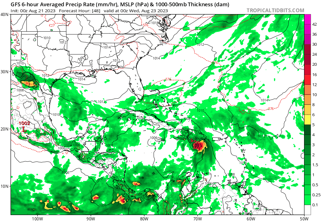
12Z GFS has this north of Hispaniola at 96 hours and TD Six is keeping the weakness open for the slow migration north over three days to near New Brunswick Canada.
At 96 hours there is a High over New England so its only TD six stalling rather than moving NE that keeps 90L from getting trapped under the ridge. Since 90L appears better organized it probably will be a threat to Hispaniola and get parked west of the Bahamas. Wouldn't take much more of a westerly shift to be a problem for New England.
0 likes
-
Hybridstorm_November2001
- S2K Supporter
- Posts: 2817
- Joined: Sat Aug 21, 2004 2:50 pm
- Location: SW New Brunswick, Canada
- Contact:
Re: ATL: INVEST 90L - Models
Nimbus wrote:aspen wrote:12z HWRF has a disorganized named storm tomorrow morning.
Could be, there is a low level circulation with light shear from the west currently.
12Z GFS has this north of Hispaniola at 96 hours and TD Six is keeping the weakness open for the slow migration north over three days to near New Brunswick Canada.
At 96 hours there is a High over New England so its only TD six stalling rather than moving NE that keeps 90L from getting trapped under the ridge. Since 90L appears better organized it probably will be a threat to Hispaniola and get parked west of the Bahamas. Wouldn't take much more of a westerly shift to be a problem for New England.
Indeed, but it is worth posting updates on my weather blog at least once a day until the situation becomes clear.
PS For fun if anyone wants to do so, my blog contains detailed archives (sat images, radar images, charts surface - 500 millibars, event summaries, etc.) of every major storm that has impacted NYC to Nova Scotia since '05: Sadny, Irene, Fiona, there are all there.
https://hybridstorm-weatherblog.blogspot.com/
Last edited by Hybridstorm_November2001 on Sun Aug 20, 2023 10:29 pm, edited 1 time in total.
2 likes
-
Hypercane_Kyle

- Category 5

- Posts: 3465
- Joined: Sat Mar 07, 2015 7:58 pm
- Location: Cape Canaveral, FL
Re: ATL: FRANKLIN - Models
Looks to me the GFS has the current LLC dying, with a new one forming to its east that organizes quickly before Hispaniola.
0 likes
My posts are my own personal opinion, defer to the National Hurricane Center (NHC) and other NOAA products for decision making during hurricane season.
-
gatorcane

- S2K Supporter
- Posts: 23704
- Age: 47
- Joined: Sun Mar 13, 2005 3:54 pm
- Location: Boca Raton, FL
Re: ATL: FRANKLIN - Models
The 18Z Euro weakens it back to a wave prior to Hispaniola due to what appears to be strong wind shear.
1 likes
-
Hybridstorm_November2001
- S2K Supporter
- Posts: 2817
- Joined: Sat Aug 21, 2004 2:50 pm
- Location: SW New Brunswick, Canada
- Contact:
Re: ATL: FRANKLIN - Models
gatorcane wrote:The 18Z Euro weakens it back to a wave prior to Hispaniola due to what appears to be strong wind shear.
I hope the Euro is correct. While a wet summer here it has been far worse in Nova Scotia, which is to our SW. NS has suffered from massive flooding all summer long the same goes for areas further west in New England such as Vermont. No areas in this general graphical neighborhood need the rains from a tropical system right now.
1 likes
-
cheezyWXguy

- Category 5
- Posts: 6272
- Joined: Mon Feb 13, 2006 12:29 am
- Location: Dallas, TX
Re: ATL: FRANKLIN - Models
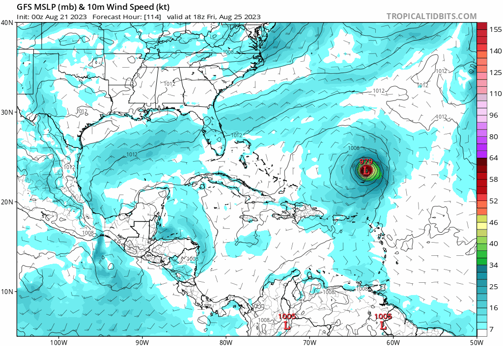
0z gfs has the ridge starting to fill back in as Franklin meanders off the east coast at 174hr
1 likes
-
ElectricStorm

- Category 5
- Posts: 5124
- Age: 24
- Joined: Tue Aug 13, 2019 11:23 pm
- Location: Norman, OK
Re: ATL: FRANKLIN - Models
0z hurricane models:
HAFS-B bombs it to 962mb before Hispaniola I highly doubt it will get close to that before landfall
HAFS-A gets to 991mb before landfall
HMON down to 991mb approaching landfall
HWRF is just starting to run so we'll see
HAFS-B bombs it to 962mb before Hispaniola
HAFS-A gets to 991mb before landfall
HMON down to 991mb approaching landfall
HWRF is just starting to run so we'll see
1 likes
B.S Meteorology, University of Oklahoma '25
Please refer to the NHC, NWS, or SPC for official information.
Please refer to the NHC, NWS, or SPC for official information.
Re: ATL: FRANKLIN - Models
Icon's incomplete right now but 12z is doing some alarming stuff with Franklin. I can't post images from here.
Last edited by BobHarlem on Mon Aug 21, 2023 10:50 am, edited 1 time in total.
0 likes
-
Blown Away

- S2K Supporter
- Posts: 10253
- Joined: Wed May 26, 2004 6:17 am
Re: ATL: FRANKLIN - Models
12z GFS… Decent W shift through 42 hours…
0 likes
Hurricane Eye Experience: David 79, Irene 99, Frances 04, Jeanne 04, Wilma 05… Hurricane Brush Experience: Andrew 92, Erin 95, Floyd 99, Matthew 16, Irma 17, Ian 22, Nicole 22…


-
Blown Away
- S2K Supporter
- Posts: 10253
- Joined: Wed May 26, 2004 6:17 am
Re: ATL: FRANKLIN - Models
Models sensing a different pattern now.
Last edited by Blown Away on Mon Aug 21, 2023 11:04 am, edited 1 time in total.
0 likes
Hurricane Eye Experience: David 79, Irene 99, Frances 04, Jeanne 04, Wilma 05… Hurricane Brush Experience: Andrew 92, Erin 95, Floyd 99, Matthew 16, Irma 17, Ian 22, Nicole 22…
Re: ATL: FRANKLIN - Models
Big shift west on 12z GFS, roughly 3.5 degrees (240 miles) west at 78 hours.
1 likes
-
Blown Away
- S2K Supporter
- Posts: 10253
- Joined: Wed May 26, 2004 6:17 am
Re: ATL: FRANKLIN - Models
12z ICON… Wow
1 likes
Hurricane Eye Experience: David 79, Irene 99, Frances 04, Jeanne 04, Wilma 05… Hurricane Brush Experience: Andrew 92, Erin 95, Floyd 99, Matthew 16, Irma 17, Ian 22, Nicole 22…
-
Blown Away
- S2K Supporter
- Posts: 10253
- Joined: Wed May 26, 2004 6:17 am
Re: ATL: FRANKLIN - Models
12z GFS… Uh oh, left turn signal on!!
1 likes
Hurricane Eye Experience: David 79, Irene 99, Frances 04, Jeanne 04, Wilma 05… Hurricane Brush Experience: Andrew 92, Erin 95, Floyd 99, Matthew 16, Irma 17, Ian 22, Nicole 22…

Re: ATL: FRANKLIN - Models
Blown Away wrote:[url]https://i.postimg.cc/NFZPN9Dw/gfs-mslp-wind-watl-fh24-132.gif [/url]
12z GFS… Uh oh, left turn signal on!!
Giving some Jeanne vibes with that hook back west
2 likes
-
Blown Away
- S2K Supporter
- Posts: 10253
- Joined: Wed May 26, 2004 6:17 am
Re: ATL: FRANKLIN - Models
12z CMC… Trend
0 likes
Hurricane Eye Experience: David 79, Irene 99, Frances 04, Jeanne 04, Wilma 05… Hurricane Brush Experience: Andrew 92, Erin 95, Floyd 99, Matthew 16, Irma 17, Ian 22, Nicole 22…
Who is online
Users browsing this forum: No registered users and 32 guests