What model and run is that SFL?
Sent from my iPhone using Tapatalk
2023 Global Model Runs Discussion (Out thru day 16)
Moderator: S2k Moderators
Forum rules

The posts in this forum are NOT official forecasts and should not be used as such. They are just the opinion of the poster and may or may not be backed by sound meteorological data. They are NOT endorsed by any professional institution or STORM2K. For official information, please refer to products from the National Hurricane Center and National Weather Service.
-
SouthFLTropics

- Category 5

- Posts: 4258
- Age: 50
- Joined: Thu Aug 14, 2003 8:04 am
- Location: Port St. Lucie, Florida
Re: 2023 Global Model Runs Discussion (Out thru day 16)
0 likes
Fourth Generation Florida Native
Personal Storm History: David 79, Andrew 92, Erin 95, Floyd 99, Irene 99, Frances 04, Jeanne 04, Wilma 05, Matthew 16, Irma 17, Ian 22, Nicole 22, Milton 24
Personal Storm History: David 79, Andrew 92, Erin 95, Floyd 99, Irene 99, Frances 04, Jeanne 04, Wilma 05, Matthew 16, Irma 17, Ian 22, Nicole 22, Milton 24
-
SFLcane

- S2K Supporter

- Posts: 10281
- Age: 48
- Joined: Sat Jun 05, 2010 1:44 pm
- Location: Lake Worth Florida
Re: 2023 Global Model Runs Discussion (Out thru day 16)
SouthFLTropics wrote:What model and run is that SFL?
Sent from my iPhone using Tapatalk
CFS, fyi did great picking up the current activity.
0 likes

Re: 2023 Global Model Runs Discussion (Out thru day 16)
SFLcane wrote:SouthFLTropics wrote:What model and run is that SFL?
Sent from my iPhone using Tapatalk
CFS, fyi did great picking up the current activity.
Did that storm the model is showing form yet or still in Africa?
0 likes
-
Hurricaneman

- Category 5
- Posts: 7404
- Age: 45
- Joined: Tue Aug 31, 2004 3:24 pm
- Location: central florida
Re: 2023 Global Model Runs Discussion (Out thru day 16)
boca wrote:SFLcane wrote:SouthFLTropics wrote:What model and run is that SFL?
Sent from my iPhone using Tapatalk
CFS, fyi did great picking up the current activity.
Did that storm the model is showing form yet or still in Africa?
That is I believe Franklin on the CFS just offshore
0 likes
-
SFLcane
- S2K Supporter
- Posts: 10281
- Age: 48
- Joined: Sat Jun 05, 2010 1:44 pm
- Location: Lake Worth Florida
Re: 2023 Global Model Runs Discussion (Out thru day 16)
Hurricaneman wrote:boca wrote:SFLcane wrote:
CFS, fyi did great picking up the current activity.
Did that storm the model is showing form yet or still in Africa?
That is I believe Franklin on the CFS just offshore
Na i think this is 92L.
0 likes
Re: 2023 Global Model Runs Discussion (Out thru day 16)
Hurricaneman wrote:boca wrote:SFLcane wrote:
CFS, fyi did great picking up the current activity.
Did that storm the model is showing form yet or still in Africa?
That is I believe Franklin on the CFS just offshore
Franklin is supposed to head north once it crosses Hispaniola towards Bermuda not towards Florida.
0 likes

Re: 2023 Global Model Runs Discussion (Out thru day 16)
boca wrote:Hurricaneman wrote:boca wrote:
Did that storm the model is showing form yet or still in Africa?
That is I believe Franklin on the CFS just offshore
Franklin is supposed to head north once it crosses Hispaniola towards Bermuda not towards Florida.
Tell that to the latest ICON run
1 likes
Re: 2023 Global Model Runs Discussion (Out thru day 16)
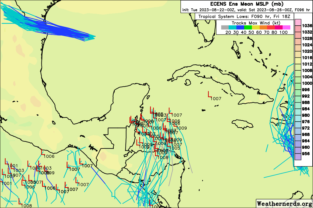
The next wave to watch is going to be coming off of Africa early next week. GFS, Euro, CMC, GEFS, and EPS show potential development with varying levels of support.
0 likes
-
wxman57

- Moderator-Pro Met

- Posts: 23175
- Age: 68
- Joined: Sat Jun 21, 2003 8:06 pm
- Location: Houston, TX (southwest)
Re: 2023 Global Model Runs Discussion (Out thru day 16)
boca wrote:Hurricaneman wrote:boca wrote:
Did that storm the model is showing form yet or still in Africa?
That is I believe Franklin on the CFS just offshore
Franklin is supposed to head north once it crosses Hispaniola towards Bermuda not towards Florida.
Definitely was 92L on the 12Z GFS. Into Pensacola in 384 hrs. Where have we seen such a forecast before?
1 likes
Re: 2023 Global Model Runs Discussion (Out thru day 16)
00Z GFS really gets the wave train going starting next week. Wouldn’t surprise me to see a couple more named storms heading into September.
0 likes
-
Ivanhater

- Storm2k Moderator

- Posts: 11222
- Age: 39
- Joined: Fri Jul 01, 2005 8:25 am
- Location: Pensacola
Re: 2023 Global Model Runs Discussion (Out thru day 16)
00Z models are in excellent agreement on a storm moving towards the Northern Gulf next week. Euro, Icon, Cmc


Sent from my moto g stylus 5G (2022) using Tapatalk
Sent from my moto g stylus 5G (2022) using Tapatalk
2 likes
Michael
-
REDHurricane

- Category 1

- Posts: 438
- Age: 28
- Joined: Sun Jul 03, 2022 2:36 pm
- Location: Northeast Pacific Ocean
Re: 2023 Global Model Runs Discussion (Out thru day 16)
Ivanhater wrote:00Z models are in excellent agreement on a storm moving towards the Northern Gulf next week. Euro, Icon, Cmc
https://uploads.tapatalk-cdn.com/20230822/a11889d685ac023e70eec334e2791f1c.jpg https://uploads.tapatalk-cdn.com/20230822/d5853560a9ad9a826796dc20048bb08a.jpg https://uploads.tapatalk-cdn.com/20230822/0de26b5bfe80f900d0dfbf05cedc1b29.jpg
Sent from my moto g stylus 5G (2022) using Tapatalk
We're eventually just going to have to skip the letter "I" in the name list altogether, aren't we
3 likes

Re: 2023 Global Model Runs Discussion (Out thru day 16)
0z Euro ensembles jumping on a storm moving into the northern Gulf next week as well: 

Sent from my iPhone using Tapatalk
Sent from my iPhone using Tapatalk
1 likes
-
jlauderdal
- S2K Supporter
- Posts: 7240
- Joined: Wed May 19, 2004 5:46 am
- Location: NE Fort Lauderdale
- Contact:
Re: 2023 Global Model Runs Discussion (Out thru day 16)
N2FSU wrote:0z Euro ensembles jumping on a storm moving into the northern Gulf next week as well: https://uploads.tapatalk-cdn.com/20230822/31bad4422f4216156e726debe8294098.jpeg
https://uploads.tapatalk-cdn.com/20230822/67cbc4f7cba081887342d13941b4872e.jpeg
Sent from my iPhone using Tapatalk
The euro had a very intense panhandle system a couple of days ago, then lost it, and now it's back with model support, it looks like we have our first big player of the season. Meanwhile, we continue to dodge systems in SE Florida...harry to the west, frank to the se and now this gulf system to the west.
0 likes
-
chris_fit

- Category 5
- Posts: 3261
- Age: 43
- Joined: Wed Sep 10, 2003 11:58 pm
- Location: Tampa Bay Area, FL
Re: 2023 Global Model Runs Discussion (Out thru day 16)
Nadda on the 06 GFZ in regards to the possible new gulf system.
0 likes
-
SFLcane
- S2K Supporter
- Posts: 10281
- Age: 48
- Joined: Sat Jun 05, 2010 1:44 pm
- Location: Lake Worth Florida
Re: 2023 Global Model Runs Discussion (Out thru day 16)
jlauderdal wrote:N2FSU wrote:0z Euro ensembles jumping on a storm moving into the northern Gulf next week as well: https://uploads.tapatalk-cdn.com/20230822/31bad4422f4216156e726debe8294098.jpeg
https://uploads.tapatalk-cdn.com/20230822/67cbc4f7cba081887342d13941b4872e.jpeg
Sent from my iPhone using Tapatalk
The euro had a very intense panhandle system a couple of days ago, then lost it, and now it's back with model support, it looks like we have our first big player of the season. Meanwhile, we continue to dodge systems in SE Florida...harry to the west, frank to the se and now this gulf system to the west.
What are we dodging if nothing has formed yet?
3 likes
-
REDHurricane
- Category 1
- Posts: 438
- Age: 28
- Joined: Sun Jul 03, 2022 2:36 pm
- Location: Northeast Pacific Ocean
Re: 2023 Global Model Runs Discussion (Out thru day 16)
SFLcane wrote:What are we dodging if nothing has formed yet?
I agree it's more likely than not that nothing significant will form from this -- all three models have the system in question originally coming from a piece of vorticity that breaks off from the EPac monsoon trough and survives crossing over a large chunk of Central America into the Gulf in about 5 days, which doesn't seem highly probable at this point. However, if I remember correctly some of the models last year were predicting the formation/approximate path of Ian about 7-8 days in advance, and the fact that 3/4 main models are showing the same general atmospheric pattern in place less than a week out isn't meaningless. The next day or two's model runs should give us a much better idea of what could happen, and it'll be interesting to see whether or not the GFS (which loves spinning up these CAG storms) jumps on board or if the other models end up trending toward the GFS solution
0 likes
-
SFLcane
- S2K Supporter
- Posts: 10281
- Age: 48
- Joined: Sat Jun 05, 2010 1:44 pm
- Location: Lake Worth Florida
Re: 2023 Global Model Runs Discussion (Out thru day 16)
Should certainly keep an eye on this area.
0 likes
-
lsuhurricane
- Category 1
- Posts: 270
- Joined: Tue Aug 15, 2017 2:53 pm
Re: 2023 Global Model Runs Discussion (Out thru day 16)
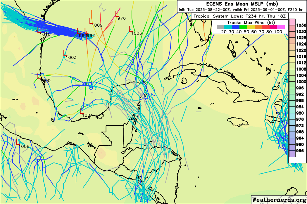
We've been down this road before (just last week) on modeled CAG type development in the 5-7 day range. GEFS showing little to no support, but otherwise, looks like something to watch seeing that its only 100-120 hours out.
0z EPS was extremely robust with development.

0z EPS was extremely robust with development.
0 likes
-
TomballEd
- Category 5
- Posts: 1318
- Age: 62
- Joined: Wed Aug 16, 2023 4:52 pm
- Location: Spring/Klein area, not Tomball
Re: 2023 Global Model Runs Discussion (Out thru day 16)
HRD scientist Andy Hazelton says the Euro has too much of a bias toward maintaining strength of features crossing land. He leans GFS, it sees the same weak disturbance crossing from the Pacific, but weakens the low level vorticity as it crosses the mountains. There are some GFS ensembles that do cross from the Pacific, but not as many
0 likes
Who is online
Users browsing this forum: No registered users and 243 guests