2023 Global Model Runs Discussion (Out thru day 16)

This is the general tropical discussion area. Anyone can take their shot at predicting a storms path.

Moderator: S2k Moderators

Forum rules

The posts in this forum are NOT official forecasts and should not be used as such. They are just the opinion of the poster and may or may not be backed by sound meteorological data. They are NOT endorsed by any professional institution or STORM2K. For official information, please refer to products from the National Hurricane Center and National Weather Service.

Help Support Storm2K
Message
Author
User avatar
SFLcane
S2K Supporter
S2K Supporter
Posts: 10162
Age: 47
Joined: Sat Jun 05, 2010 1:44 pm
Location: Lake Worth Florida

Re: 2023 Global Model Runs Discussion (Out thru day 16)

#1241 Postby SFLcane » Wed Aug 23, 2023 1:23 pm

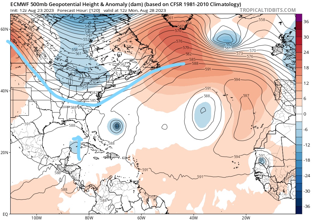
SouthFLTropics wrote:Euro is jumping onboard the Yucatan disturbance. Think we may have a player for Florida. And unfortunately, it will most likely get the dreaded "I" name. Hopefully the curse of that letter storm can be broken, and this just stay weak.


Caribbean lemon incoming!
0 likes   

User avatar
SouthFLTropics
Category 5
Category 5
Posts: 4236
Age: 49
Joined: Thu Aug 14, 2003 8:04 am
Location: Port St. Lucie, Florida

Re: 2023 Global Model Runs Discussion (Out thru day 16)

#1242 Postby SouthFLTropics » Wed Aug 23, 2023 1:31 pm

Ruh Roh... Zoinks!!! :eek:

Image
0 likes   
Fourth Generation Florida Native

Personal Storm History: David 79, Andrew 92, Erin 95, Floyd 99, Irene 99, Frances 04, Jeanne 04, Wilma 05, Matthew 16, Irma 17, Ian 22, Nicole 22, Milton 24

User avatar
SFLcane
S2K Supporter
S2K Supporter
Posts: 10162
Age: 47
Joined: Sat Jun 05, 2010 1:44 pm
Location: Lake Worth Florida

Re: 2023 Global Model Runs Discussion (Out thru day 16)

#1243 Postby SFLcane » Wed Aug 23, 2023 1:32 pm

SouthFLTropics wrote:Ruh Roh... Zoinks!!! :eek:

https://i.imgur.com/vUBgWD0.png


Image
0 likes   

User avatar
SFLcane
S2K Supporter
S2K Supporter
Posts: 10162
Age: 47
Joined: Sat Jun 05, 2010 1:44 pm
Location: Lake Worth Florida

Re: 2023 Global Model Runs Discussion (Out thru day 16)

#1244 Postby SFLcane » Wed Aug 23, 2023 1:37 pm

978mb... woah :eek:
Last edited by SFLcane on Wed Aug 23, 2023 1:37 pm, edited 1 time in total.
0 likes   

User avatar
SouthFLTropics
Category 5
Category 5
Posts: 4236
Age: 49
Joined: Thu Aug 14, 2003 8:04 am
Location: Port St. Lucie, Florida

Re: 2023 Global Model Runs Discussion (Out thru day 16)

#1245 Postby SouthFLTropics » Wed Aug 23, 2023 1:37 pm

Image
0 likes   
Fourth Generation Florida Native

Personal Storm History: David 79, Andrew 92, Erin 95, Floyd 99, Irene 99, Frances 04, Jeanne 04, Wilma 05, Matthew 16, Irma 17, Ian 22, Nicole 22, Milton 24

Stormcenter
S2K Supporter
S2K Supporter
Posts: 6677
Joined: Wed Sep 03, 2003 11:27 am
Location: Houston, TX

Re: 2023 Global Model Runs Discussion (Out thru day 16)

#1246 Postby Stormcenter » Wed Aug 23, 2023 1:38 pm

Is it still hurricane season? Seriously though I’ll go out a
short limb here and predict the bulk of the storms
that threaten the U.S. will come in mid-late Sept.
and all of Oct.
0 likes   

Ianswfl
Category 1
Category 1
Posts: 482
Joined: Thu Mar 23, 2023 11:11 pm

Re: 2023 Global Model Runs Discussion (Out thru day 16)

#1247 Postby Ianswfl » Wed Aug 23, 2023 1:39 pm

Cat2 big bend but at least its small not large like Ian. But just a bit of a east nudge and it's southwest florida again.

Even a compact weak cat2 hlw long would that set back Ian recovery?
0 likes   

User avatar
SFLcane
S2K Supporter
S2K Supporter
Posts: 10162
Age: 47
Joined: Sat Jun 05, 2010 1:44 pm
Location: Lake Worth Florida

Re: 2023 Global Model Runs Discussion (Out thru day 16)

#1248 Postby SFLcane » Wed Aug 23, 2023 1:41 pm

EPS should been fun lol...
0 likes   

User avatar
SouthFLTropics
Category 5
Category 5
Posts: 4236
Age: 49
Joined: Thu Aug 14, 2003 8:04 am
Location: Port St. Lucie, Florida

Re: 2023 Global Model Runs Discussion (Out thru day 16)

#1249 Postby SouthFLTropics » Wed Aug 23, 2023 1:42 pm

I would think that area east of the Yucatan gets a lemon by 8:00 PM or at the very least by 2:00 AM.
0 likes   
Fourth Generation Florida Native

Personal Storm History: David 79, Andrew 92, Erin 95, Floyd 99, Irene 99, Frances 04, Jeanne 04, Wilma 05, Matthew 16, Irma 17, Ian 22, Nicole 22, Milton 24

AutoPenalti
Category 5
Category 5
Posts: 4029
Age: 28
Joined: Mon Aug 17, 2015 4:16 pm
Location: Ft. Lauderdale, Florida

Re: 2023 Global Model Runs Discussion (Out thru day 16)

#1250 Postby AutoPenalti » Wed Aug 23, 2023 1:43 pm

Last edited by AutoPenalti on Wed Aug 23, 2023 1:43 pm, edited 1 time in total.
0 likes   
The posts in this forum are NOT official forecasts and should not be used as such. They are just the opinion of the poster and may or may not be backed by sound meteorological data. They are NOT endorsed by any professional institution or STORM2K. For official information, please refer to products from the NHC and NWS.


Model Runs Cheat Sheet:
GFS (5:30 AM/PM, 11:30 AM/PM)
HWRF, GFDL, UKMET, NAVGEM (6:30-8:00 AM/PM, 12:30-2:00 AM/PM)
ECMWF (1:45 AM/PM)

TCVN
is a weighted averaged

User avatar
N2FSU
S2K Supporter
S2K Supporter
Posts: 1062
Joined: Thu Sep 04, 2003 2:04 pm
Location: Tallahassee, FL

Re: 2023 Global Model Runs Discussion (Out thru day 16)

#1251 Postby N2FSU » Wed Aug 23, 2023 1:43 pm

12z EuroImage


Image


Sent from my iPhone using Tapatalk
1 likes   

User avatar
Jr0d
S2K Supporter
S2K Supporter
Posts: 1394
Joined: Tue Aug 27, 2019 10:52 am
Location: Cayo Hueso

Re: 2023 Global Model Runs Discussion (Out thru day 16)

#1252 Postby Jr0d » Wed Aug 23, 2023 1:43 pm

Ianswfl wrote:Cat2 big bend but at least its small not large like Ian. But just a bit of a east nudge and it's southwest florida again.

Even a compact weak cat2 hlw long would that set back Ian recovery?


Even a compact 2 that is not zipping along can create a devastating surge in Tampa Bay if it were to take a direct hit or slightly north.

Still a phantom storm so way too early to speculate exact landfall locations though.

Definitely worth watching of course. Further south would be tough for those rebuilding after Ian.
0 likes   

User avatar
Steve
S2K Supporter
S2K Supporter
Posts: 9591
Joined: Sat Apr 05, 2003 11:41 pm
Location: Not a state-caster

Re: 2023 Global Model Runs Discussion (Out thru day 16)

#1253 Postby Steve » Wed Aug 23, 2023 1:45 pm

SouthFLTropics wrote:Ruh Roh... Zoinks!!! :eek:

https://i.imgur.com/vUBgWD0.png


I’m not big on the solution at that resolution. If it’s more toward Apalachicola-Panama City, you could argue for a maintaining or strengthening system coming in. Same for Tampa and south. But anything from Alligator Point down to Horseshoe Beach is almost always weaker and going to be fading at landfall. However as hot as the Gulf is, I’m hedging a little on climo.

We are only talking a week out, so we won’t have to wait long to see what happens. ICON has mostly been the leader on this. And maybe there isn’t much steering in the southern Gulf or near the SW Coast of Florida to be in a hurry. But that will get clearer too over the weekend.
0 likes   

jlauderdal
S2K Supporter
S2K Supporter
Posts: 7177
Joined: Wed May 19, 2004 5:46 am
Location: NE Fort Lauderdale
Contact:

Re: RE: Re: 2023 Global Model Runs Discussion (Out thru day 16)

#1254 Postby jlauderdal » Wed Aug 23, 2023 1:45 pm

SouthFLTropics wrote:I would think that area east of the Yucatan gets a lemon by 8:00 PM or at the very least by 2:00 AM.
The chasers like the looks of that setup and location.
0 likes   

User avatar
SouthFLTropics
Category 5
Category 5
Posts: 4236
Age: 49
Joined: Thu Aug 14, 2003 8:04 am
Location: Port St. Lucie, Florida

Re: 2023 Global Model Runs Discussion (Out thru day 16)

#1255 Postby SouthFLTropics » Wed Aug 23, 2023 1:45 pm

The thing is, the Euro is not alone on this. The CMC and Icon have it also. Ironically, the GFS which typically blows up everything from a CAG is alone on an island and showing nothing.
1 likes   
Fourth Generation Florida Native

Personal Storm History: David 79, Andrew 92, Erin 95, Floyd 99, Irene 99, Frances 04, Jeanne 04, Wilma 05, Matthew 16, Irma 17, Ian 22, Nicole 22, Milton 24

User avatar
Jr0d
S2K Supporter
S2K Supporter
Posts: 1394
Joined: Tue Aug 27, 2019 10:52 am
Location: Cayo Hueso

Re: 2023 Global Model Runs Discussion (Out thru day 16)

#1256 Postby Jr0d » Wed Aug 23, 2023 1:47 pm

SouthFLTropics wrote:I would think that area east of the Yucatan gets a lemon by 8:00 PM or at the very least by 2:00 AM.


The spin over Yucatan is an upper level low so it will not develop. No need for a lemon yet...
0 likes   

User avatar
SouthFLTropics
Category 5
Category 5
Posts: 4236
Age: 49
Joined: Thu Aug 14, 2003 8:04 am
Location: Port St. Lucie, Florida

Re: 2023 Global Model Runs Discussion (Out thru day 16)

#1257 Postby SouthFLTropics » Wed Aug 23, 2023 1:48 pm

Jr0d wrote:
SouthFLTropics wrote:I would think that area east of the Yucatan gets a lemon by 8:00 PM or at the very least by 2:00 AM.


The spin over Yucatan is an upper level low so it will not develop. No need for a lemon yet...


Lemon would start further south near Honduras. That is where the energy from this is going to come from.
0 likes   
Fourth Generation Florida Native

Personal Storm History: David 79, Andrew 92, Erin 95, Floyd 99, Irene 99, Frances 04, Jeanne 04, Wilma 05, Matthew 16, Irma 17, Ian 22, Nicole 22, Milton 24

User avatar
SFLcane
S2K Supporter
S2K Supporter
Posts: 10162
Age: 47
Joined: Sat Jun 05, 2010 1:44 pm
Location: Lake Worth Florida

Re: 2023 Global Model Runs Discussion (Out thru day 16)

#1258 Postby SFLcane » Wed Aug 23, 2023 1:51 pm

That persistent eastcoast trof so far this season keeping franklin away could be florida's worse enemy if something develops down there.


Image
Last edited by SFLcane on Wed Aug 23, 2023 1:53 pm, edited 1 time in total.
3 likes   

User avatar
SouthFLTropics
Category 5
Category 5
Posts: 4236
Age: 49
Joined: Thu Aug 14, 2003 8:04 am
Location: Port St. Lucie, Florida

Re: 2023 Global Model Runs Discussion (Out thru day 16)

#1259 Postby SouthFLTropics » Wed Aug 23, 2023 1:52 pm

Take a closer look at the energy just east of Nicaragua. There is already some spin evident there. If something forms, it appears it comes out of this area.

Image
0 likes   
Fourth Generation Florida Native

Personal Storm History: David 79, Andrew 92, Erin 95, Floyd 99, Irene 99, Frances 04, Jeanne 04, Wilma 05, Matthew 16, Irma 17, Ian 22, Nicole 22, Milton 24

Ianswfl
Category 1
Category 1
Posts: 482
Joined: Thu Mar 23, 2023 11:11 pm

Re: 2023 Global Model Runs Discussion (Out thru day 16)

#1260 Postby Ianswfl » Wed Aug 23, 2023 1:54 pm

SouthFLTropics wrote:The thing is, the Euro is not alone on this. The CMC and Icon have it also. Ironically, the GFS which typically blows up everything from a CAG is alone on an island and showing nothing.


Gfs shows that energy next week but it's sheared out but has the moisture.
0 likes   


Return to “Talkin' Tropics”

Who is online

Users browsing this forum: No registered users and 156 guests