Low Pressure in the Northwest Caribbean Sea (Is Invest 93L)
Moderator: S2k Moderators
Forum rules

The posts in this forum are NOT official forecasts and should not be used as such. They are just the opinion of the poster and may or may not be backed by sound meteorological data. They are NOT endorsed by any professional institution or STORM2K. For official information, please refer to products from the National Hurricane Center and National Weather Service.
-
tropicwatch

- Category 5

- Posts: 3427
- Age: 62
- Joined: Sat Jun 02, 2007 10:01 am
- Location: The Villages, Florida
- Contact:
Re: Possible Development in the Western Caribbean
There is a lemon from the NHC.
3 likes
Tropicwatch
Agnes 72', Eloise 75, Elena 85', Kate 85', Charley 86', Florence 88', Beryl 94', Dean 95', Erin 95', Opal 95', Earl 98', Georges 98', Ivan 2004', Arlene 2005', Dennis 2005', Ida 2009' Debby 2012' Irma 2017' Michael 2018'
Agnes 72', Eloise 75, Elena 85', Kate 85', Charley 86', Florence 88', Beryl 94', Dean 95', Erin 95', Opal 95', Earl 98', Georges 98', Ivan 2004', Arlene 2005', Dennis 2005', Ida 2009' Debby 2012' Irma 2017' Michael 2018'
-
cycloneye

- Admin

- Posts: 149712
- Age: 69
- Joined: Thu Oct 10, 2002 10:54 am
- Location: San Juan, Puerto Rico
Re: Possible Development in the Western Caribbean
3. Northwestern Caribbean Sea:
An area of low pressure could form in a couple of days over the
northwestern Caribbean Sea. Some slow development of this system
is possible over the weekend and early next week while it moves
slowly northward across the eastern Gulf of Mexico.
* Formation chance through 48 hours...low...near 0 percent.
* Formation chance through 7 days...low...20 percent.

0 likes
Visit the Caribbean-Central America Weather Thread where you can find at first post web cams,radars
and observations from Caribbean basin members Click Here
and observations from Caribbean basin members Click Here

Re: Possible Development in the Western Caribbean
I don't like how the EURO is slower with an extra 24 hours over water before finding Florida.
For now its something to watch for early next week, too early of course to speculate future land fall and strength but not something I have any concerns about.
For now its something to watch for early next week, too early of course to speculate future land fall and strength but not something I have any concerns about.
1 likes
-
gatorcane

- S2K Supporter

- Posts: 23708
- Age: 48
- Joined: Sun Mar 13, 2005 3:54 pm
- Location: Boca Raton, FL
Re: Possible Development in the Northwestern Caribbean: Added to 8 PM TWO
Ghost town on the GFS ensembles, I think I see one with development in the BOC but we have the very bearish GFS and its ensembles vs the bullish Euro and ensembles.
0 likes


Re: Possible Development in the Western Caribbean
IcyTundra wrote:Spacecoast wrote:How often does EPAC - ATL crossovers occur? It seems rare. The only example I found was Unnamed 1902 which was further north over to Bay of Compeche.
4 times as far as I know it's a really rare event.
https://i.ibb.co/48g9T8z/hurricane-UNNAMED-1842.png
Missing here is TS Cristobal 2020 which formed from Amanda's remnant low from the EPAC.
0 likes
Re: Possible Development in the Northwestern Caribbean: Added to 8 PM TWO
gatorcane wrote:Ghost town on the GFS ensembles, I think I see one with development in the BOC but we have the very bearish GFS and its ensembles vs the bullish Euro and ensembles.
That's how the GFS initially was with Franklin and Harold with not much ensemble support.
2 likes
Re: Possible Development in the Northwestern Caribbean
SFLcane wrote:Can’t say I didn’t tell ya lol.
https://twitter.com/andyhazelton/status/1694503265314996588?s=46&t=sStb56JhzYdUjITqDzKFmQ
He's looking for anything to discredit the Euro, that's how he was when the Euro was showing Franklin to form but the GFS was not. Lol.
2 likes
-
Hypercane_Kyle

- Category 5
- Posts: 3465
- Joined: Sat Mar 07, 2015 7:58 pm
- Location: Cape Canaveral, FL
Re: Possible Development in the Northwestern Caribbean
NDG wrote:SFLcane wrote:Can’t say I didn’t tell ya lol.
https://twitter.com/andyhazelton/status/1694503265314996588?s=46&t=sStb56JhzYdUjITqDzKFmQ
He's looking for anything to discredit the Euro, that's how he was when the Euro was showing Franklin to form but the GFS was not. Lol.
I don't see how he's wrong here. The Euro is having terrible consistency.
2 likes
My posts are my own personal opinion, defer to the National Hurricane Center (NHC) and other NOAA products for decision making during hurricane season.
Re: Possible Development in the Northwestern Caribbean
When EC, Gem, Icon are in an agreement, simply ignore the GFS.
1 likes
Re: Possible Development in the Northwestern Caribbean
Still On the 18z Canadian (only goes out to 84 hours)

from: https://meteocentre.com/numerical-weath ... type=dateo
from: https://meteocentre.com/numerical-weath ... type=dateo
0 likes
-
Stratton23
- Category 5
- Posts: 3575
- Joined: Fri Jul 21, 2023 10:59 pm
- Location: Katy, Tx
Re: Possible Development in the Northwestern Caribbean
The GFS has been absolutely terrible with genesis this year, I would not pay much attention to it, it will cave into the euro , CMC and ICON
1 likes

Re: Possible Development in the Northwestern Caribbean
Stratton23 wrote:The GFS has been absolutely terrible with genesis this year, I would not pay much attention to it, it will cave into the euro , CMC and ICON
Agreed.
The longer this takes to develop, the better odds we will have in Texas. The faster it develops, better odds for Florida.
1 likes
-
Spacecoast

- Category 2

- Posts: 773
- Joined: Thu Aug 31, 2017 2:03 pm


Re: Possible Development in the Northwestern Caribbean
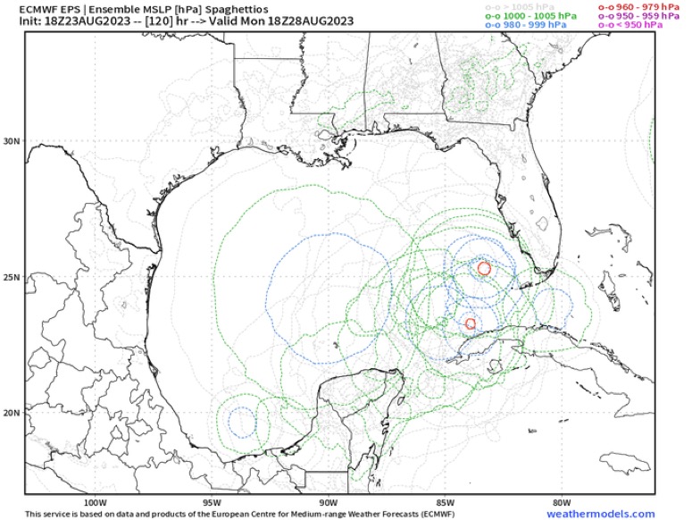
More east the 18z and a couple members are 115mph same general path as Ian except maybe getting stronger before landfall.
Also note the time! 18z monday some of the members are just hours away from landfall of a major. Not much time here to prepare, especially being the weekend and everyone out doing stuff might be ignoring the news.
0 likes

Re: Possible Development in the Northwestern Caribbean

0 likes
The following post is NOT an official forecast and should not be used as such. It is just the opinion of the poster and may or may not be backed by sound meteorological data. It is NOT endorsed by any professional institution including storm2k.org For Official Information please refer to the NHC and NWS products.
Re: Possible Development in the Northwestern Caribbean
The euro ensembles are faster with this. By monday night some members have a cat3 in the SE Gulf, landfall sometime late Tue.
0 likes
Re: Possible Development in the Northwestern Caribbean
No mention in the NWS Key West. Maybe they will say something about it tomorrow.
Some of the models show a significant impact here, but right now just something to watch nothing to be concerned about.
Some of the models show a significant impact here, but right now just something to watch nothing to be concerned about.
0 likes
Re: Possible Development in the Northwestern Caribbean
Jr0d wrote:No mention in the NWS Key West. Maybe they will say something about it tomorrow.
Some of the models show a significant impact here, but right now just something to watch nothing to be concerned about.
Wouldn't crank up to a cat2 likely until after the Keys.
0 likes
Who is online
Users browsing this forum: Ed_2001, pepecool20 and 210 guests