
NHC Update
https://www.youtube.com/watch?v=30JeBr0swzw
ATL: IDALIA - Post-Tropical - Discussion
Moderator: S2k Moderators
Re: ATL: INVEST 93L - Discussion
Last edited by GCANE on Sat Aug 26, 2023 11:11 am, edited 1 time in total.
2 likes
-
cycloneye

- Admin

- Posts: 149716
- Age: 69
- Joined: Thu Oct 10, 2002 10:54 am
- Location: San Juan, Puerto Rico
Re: ATL: INVEST 93L - Discussion
0 likes
Visit the Caribbean-Central America Weather Thread where you can find at first post web cams,radars
and observations from Caribbean basin members Click Here
and observations from Caribbean basin members Click Here

Re: ATL: INVEST 93L - Discussion
(V)Idalia may be a real "tear-jerker" 
3 likes
Andy D
(For official information, please refer to the NHC and NWS products.)
(For official information, please refer to the NHC and NWS products.)

Re: ATL: INVEST 93L - Discussion
12z soundings from this morning confirms the strong ridge in the south central FL extending east towards the SE US, the reason 93L will not move much during the next couple of days, as a shortwave troughs digs down over the MS river valley and just west it will push the ridge westward and 93L will start moving north out of the Caribbean, at the same time ridging will nose in just east of S FL from the central Caribbean to keep it from moving too much east.

2 likes
-
ConvergenceZone
.gif)
- Category 5

- Posts: 5241
- Joined: Fri Jul 29, 2005 1:40 am
- Location: Northern California
Re: ATL: INVEST 93L - Discussion
The Weather Channel seems to think this will most likely Top out as a Tropical Storm only, but will still bring some big soaking rains to Florida...............Let's hope it moves fast once it landfalls.
0 likes
Re: ATL: INVEST 93L - Discussion
2. SUSPECT AREA (NW CARIBBEAN - AL93)
FLIGHT ONE - NOAA 43 FLIGHT TWO - TEAL 71
A. 27/1400Z A. 27/1500Z
B. NOAA3 01DDAA TDR B. AFXXX 02DDA INVEST
C. 27/1000Z C. 27/1230Z
D. 21.3N 86.5W D. 21.3N 86.5W
E. 27/1330Z TO 27/1630Z E. 27/1430Z TO 27/1900Z
F. SFC TO 15,000 FT F. SFC TO 15,000 FT
G. TAIL DOPPLER RADAR G. LOW LEVEL INVEST
FLIGHT THREE - NOAA 49 FLIGHT FOUR - TEAL 72
A. 28/0000Z A. 28/0530Z
B. NOAA9 03DDA SURV B. AFXXX 0410A CYCLONE
C. 27/1730Z C. 28/0300Z
D. NA D. 21.8N 86.5W
E. NA E. 28/0500Z TO 28/0830Z
F. 41,000 TO 45,000 FT F. SFC TO 10,000 FT
G. SYNOPTIC SURVEILLANCE G. FIX
FLIGHT FIVE - NOAA 49 FLIGHT SIX - TEAL 73
A. 28/1200Z A. 28/1130Z,1730Z
B. NOAA9 0510A CYCLONE B. AFXXX 0610A CYCLONE
C. 28/0530Z C. 28/0900Z
D. NA D. 22.1N 86.5W
E. NA E. 28/1100Z TO 28/1730Z
F. 41,000 TO 45,000 FT F. SFC TO 15,000 FT
G. SYNOPTIC SURVEILLANCE G. FIX
FLIGHT SEVEN - NOAA 43
A. 28/1200Z
B. NOAA3 0710A CYCLONE
C. 28/1000Z
D. 22.1N 86.5W
E. 28/1130Z TO 28/1530Z
F. SFC TO 15,000 FT
G. TAIL DOPPLER RADAR
0 likes
Re: ATL: INVEST 93L - Discussion
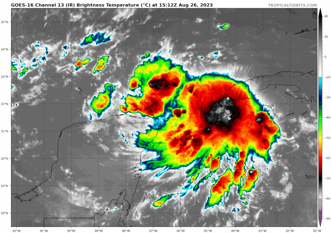
CoC seems to be over the water just offshore Cuba
Feeder band continues to strengthen.
Visible satellite looks better by the minute.
99% sure this is a TD
Feeder band continues to strengthen.
Visible satellite looks better by the minute.
99% sure this is a TD
3 likes
-
Hurricaneman

- Category 5
- Posts: 7404
- Age: 45
- Joined: Tue Aug 31, 2004 3:24 pm
- Location: central florida
Re: ATL: INVEST 93L - Discussion
By the time recon gets there this could be a 50 to 60mph TS
1 likes
-
SFLcane

- S2K Supporter

- Posts: 10281
- Age: 48
- Joined: Sat Jun 05, 2010 1:44 pm
- Location: Lake Worth Florida
Re: ATL: INVEST 93L - Discussion
Wondering if the center could reform to the east were the deep convection is..
Last edited by SFLcane on Sat Aug 26, 2023 11:32 am, edited 1 time in total.
2 likes
Re: ATL: INVEST 93L - Discussion
ConvergenceZone wrote:The Weather Channel seems to think this will most likely Top out as a Tropical Storm only, but will still bring some big soaking rains to Florida...............Let's hope it moves fast once it landfalls.
Interesting they are being conservative with 93L this early on when is coming from the same place that forecasted the most aggressive season forecast.
0 likes
Re: ATL: INVEST 93L - Discussion
Hurricaneman wrote:By the time recon gets there this could be a 50 to 60mph TS
Agreed. It would be better if we have recon today.
0 likes
Re: ATL: INVEST 93L - Discussion
SFLcane wrote:Wondering if the center could reform to the east were the deep convection is..
The system is not sheared. I don't see center reformation happening.
1 likes
-
cheezyWXguy

- Category 5
- Posts: 6282
- Joined: Mon Feb 13, 2006 12:29 am
- Location: Dallas, TX
Re: ATL: INVEST 93L - Discussion
ConvergenceZone wrote:The Weather Channel seems to think this will most likely Top out as a Tropical Storm only, but will still bring some big soaking rains to Florida...............Let's hope it moves fast once it landfalls.
Considering that their main objective is public awareness, this is the right call until this thing develops. There are some signs that the potential intensity ceiling is higher than initially thought, but it would cause unnecessary worry to bring that the general public for now
0 likes
Re: ATL: INVEST 93L - Discussion
Imagine the last minute Cruise ittinerary changes going on right now? Especially those cruises just now departing Belize or those ships presently in Cancun or Cozumel scheduled to depart back to S. Florida ports?
"Sorry folks, the Limbo challange on the Lido deck has been cancelled on account of mass nausea..."
"Sorry folks, the Limbo challange on the Lido deck has been cancelled on account of mass nausea..."
3 likes
Andy D
(For official information, please refer to the NHC and NWS products.)
(For official information, please refer to the NHC and NWS products.)
-
ElectricStorm

- Category 5
- Posts: 5155
- Age: 25
- Joined: Tue Aug 13, 2019 11:23 pm
- Location: Norman, OK
Re: ATL: INVEST 93L - Discussion
Hurricaneman wrote:By the time recon gets there this could be a 50 to 60mph TS
If it can stay away from land it might be able to, but with it meandering around for a while down there it could end up moving over the Yucatan or Cuba. We'll see
1 likes
B.S Meteorology, University of Oklahoma '25
Please refer to the NHC, NWS, or SPC for official information.
Please refer to the NHC, NWS, or SPC for official information.
-
cycloneye
- Admin
- Posts: 149716
- Age: 69
- Joined: Thu Oct 10, 2002 10:54 am
- Location: San Juan, Puerto Rico
Re: ATL: INVEST 93L - Discussion: Breaking news=No recon for today / First one Sunday at 6 AM EDT
0 likes
Visit the Caribbean-Central America Weather Thread where you can find at first post web cams,radars
and observations from Caribbean basin members Click Here
and observations from Caribbean basin members Click Here

Re: ATL: INVEST 93L - Discussion: Breaking news=No recon for today / First one Sunday at 6 AM EDT
I think by the time the recon get there we would have a strong tropical storm on are hands?
0 likes
Re: ATL: INVEST 93L - Discussion
ElectricStorm wrote:Hurricaneman wrote:By the time recon gets there this could be a 50 to 60mph TS
If it can stay away from land it might be able to, but with it meandering around for a while down there it could end up moving over the Yucatan or Cuba. We'll see
Was thinking the same thing. In fact, if i were to guess any erratic drift or short term motion, I would guess it would be between west and NW.
0 likes
Andy D
(For official information, please refer to the NHC and NWS products.)
(For official information, please refer to the NHC and NWS products.)
Re: ATL: INVEST 93L - Discussion: Breaking news=No recon for today / First one Sunday at 6 AM EDT
Special advisory could happen at any time since now. I don't think they even want to wait until next TWO.
0 likes
Who is online
Users browsing this forum: No registered users and 75 guests