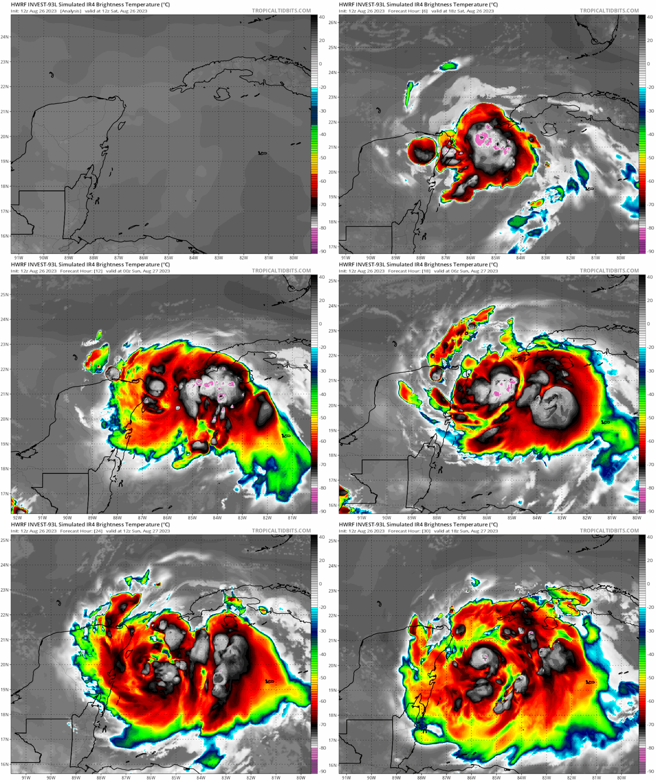
ATL: IDALIA - Models

Moderator: S2k Moderators

Message
Author
User avatar
chaser1
S2K Supporter
S2K Supporter
Posts: 5464
Age: 64
Joined: Sat Oct 15, 2005 5:59 pm
Location: Longwood, Fl

Re: ATL: INVEST 93L - Models

#181 Postby chaser1 » Sat Aug 26, 2023 12:12 pm

NDG wrote:
chris_fit wrote:GFS Trend. 93l looks roughly the same, but look at Franklin. Keeps adjusting S/W - What implications will that have on 93l?


https://i.imgur.com/9mtI4Pw.gif


It pushes the narrow ridge nose between it and 93L west or WSW, so does 93L.

https://i.imgur.com/EIicOFB.gif


Part of me wonders about that small nudging ridge between Franklin and 93. I would almost expect the ridge to erode thus suggesting a possible easward component to forward motion?
0 likes   
Andy D

(For official information, please refer to the NHC and NWS products.)

User avatar
ElectricStorm
Category 5
Category 5
Posts: 5044
Age: 24
Joined: Tue Aug 13, 2019 11:23 pm
Location: Skiatook, OK / Norman, OK

Re: ATL: INVEST 93L - Models

#182 Postby ElectricStorm » Sat Aug 26, 2023 12:13 pm

Looks like HMON has it going over the Yucatan for a bit, still recovers nicely though and has a strong TS in the gulf so far
0 likes   
B.S Meteorology, University of Oklahoma '25

Please refer to the NHC, NWS, or SPC for official information.

User avatar
NDG
S2K Supporter
S2K Supporter
Posts: 15446
Joined: Sun Jul 09, 2006 10:14 pm
Location: Orlando, FL

Re: ATL: INVEST 93L - Models

#183 Postby NDG » Sat Aug 26, 2023 12:15 pm

12z HWRF is the strongest run so far in the short term.
0 likes   

User avatar
Spacecoast
Category 2
Category 2
Posts: 758
Joined: Thu Aug 31, 2017 2:03 pm

Re: ATL: INVEST 93L - Models

#184 Postby Spacecoast » Sat Aug 26, 2023 12:18 pm

12z GEFS:
Image
0 likes   

User avatar
NDG
S2K Supporter
S2K Supporter
Posts: 15446
Joined: Sun Jul 09, 2006 10:14 pm
Location: Orlando, FL

Re: ATL: INVEST 93L - Models

#185 Postby NDG » Sat Aug 26, 2023 12:18 pm

HAFS-B Cat 3 at hr 72.

Image
1 likes   

Ianswfl
Category 1
Category 1
Posts: 482
Joined: Thu Mar 23, 2023 11:11 pm

Re: ATL: INVEST 93L - Models

#186 Postby Ianswfl » Sat Aug 26, 2023 12:19 pm

NDG wrote:12z HWRF is the strongest run so far in the short term.


And more east than 6z that was into ft myers
0 likes   

User avatar
ElectricStorm
Category 5
Category 5
Posts: 5044
Age: 24
Joined: Tue Aug 13, 2019 11:23 pm
Location: Skiatook, OK / Norman, OK

Re: ATL: INVEST 93L - Models

#187 Postby ElectricStorm » Sat Aug 26, 2023 12:23 pm

bruh
Image
2 likes   
B.S Meteorology, University of Oklahoma '25

Please refer to the NHC, NWS, or SPC for official information.

User avatar
NDG
S2K Supporter
S2K Supporter
Posts: 15446
Joined: Sun Jul 09, 2006 10:14 pm
Location: Orlando, FL

Re: ATL: INVEST 93L - Models

#188 Postby NDG » Sat Aug 26, 2023 12:23 pm

Andy Hazelton's beloved model as a Cat 4 before landfall.

Image
0 likes   

User avatar
gatorcane
S2K Supporter
S2K Supporter
Posts: 23691
Age: 47
Joined: Sun Mar 13, 2005 3:54 pm
Location: Boca Raton, FL

Re: ATL: INVEST 93L - Models

#189 Postby gatorcane » Sat Aug 26, 2023 12:23 pm

Ianswfl wrote:
NDG wrote:12z HWRF is the strongest run so far in the short term.


And more east than 6z that was into ft myers


Yes HWRF is much stronger and more east through 30 hours.983MB :eek:

Image
0 likes   

SunnyThoughts
Category 5
Category 5
Posts: 2263
Joined: Wed Jul 09, 2003 12:42 pm
Location: Pensacola, Florida

Re: ATL: INVEST 93L - Models

#190 Postby SunnyThoughts » Sat Aug 26, 2023 12:25 pm

I was gonna say, HWRF would probably end up showing a cat 5 somewhere in the next few runs. Looks like that HAFS may beat it to the punch.
0 likes   

AutoPenalti
Category 5
Category 5
Posts: 4030
Age: 29
Joined: Mon Aug 17, 2015 4:16 pm
Location: Ft. Lauderdale, Florida

Re: ATL: INVEST 93L - Models

#191 Postby AutoPenalti » Sat Aug 26, 2023 12:26 pm

Yeah, I don’t know if that HWRF is going to verify…
1 likes   
The posts in this forum are NOT official forecasts and should not be used as such. They are just the opinion of the poster and may or may not be backed by sound meteorological data. They are NOT endorsed by any professional institution or STORM2K. For official information, please refer to products from the NHC and NWS.


Model Runs Cheat Sheet:
GFS (5:30 AM/PM, 11:30 AM/PM)
HWRF, GFDL, UKMET, NAVGEM (6:30-8:00 AM/PM, 12:30-2:00 AM/PM)
ECMWF (1:45 AM/PM)

TCVN
is a weighted averaged

jlauderdal
S2K Supporter
S2K Supporter
Posts: 7182
Joined: Wed May 19, 2004 5:46 am
Location: NE Fort Lauderdale
Contact:

Re: RE: Re: ATL: INVEST 93L - Models

#192 Postby jlauderdal » Sat Aug 26, 2023 12:26 pm

gatorcane wrote:
Ianswfl wrote:
NDG wrote:12z HWRF is the strongest run so far in the short term.


And more east than 6z that was into ft myers


Yes HWRF is much stronger and more east through 30 hours.983MB :eek:

Image
All interests from key west to the bama ga line, hurricane season is back.
3 likes   

Fancy1002
Tropical Storm
Tropical Storm
Posts: 134
Joined: Sun Dec 25, 2022 3:47 pm

Re: ATL: INVEST 93L - Models

#193 Postby Fancy1002 » Sat Aug 26, 2023 12:31 pm

ElectricStorm wrote:bruh
https://i.imgur.com/BVE6Hsp.png

The return of Michael!
0 likes   

User avatar
Blown Away
S2K Supporter
S2K Supporter
Posts: 10145
Joined: Wed May 26, 2004 6:17 am

Re: ATL: INVEST 93L - Models

#194 Postby Blown Away » Sat Aug 26, 2023 12:32 pm

NDG wrote:Andy Hazelton's beloved model as a Cat 4 before landfall.

https://i.imgur.com/EKiy14G.png


The extraordinarily rare Major into the Big Bend area.
0 likes   
Hurricane Eye Experience: David 79, Irene 99, Frances 04, Jeanne 04, Wilma 05... EYE COMING MY WAY IN 2024…
Hurricane Brush Experience: Andrew 92, Erin 95, Floyd 99, Matthew 16, Irma 17, Ian 22, Nicole 22…

User avatar
ElectricStorm
Category 5
Category 5
Posts: 5044
Age: 24
Joined: Tue Aug 13, 2019 11:23 pm
Location: Skiatook, OK / Norman, OK

Re: ATL: INVEST 93L - Models

#195 Postby ElectricStorm » Sat Aug 26, 2023 12:33 pm

HAFS-A has a Cat 3
Image
0 likes   
B.S Meteorology, University of Oklahoma '25

Please refer to the NHC, NWS, or SPC for official information.

User avatar
MississippiWx
S2K Supporter
S2K Supporter
Posts: 1699
Joined: Sat Aug 14, 2010 1:44 pm
Location: Hattiesburg, Mississippi

Re: ATL: INVEST 93L - Models

#196 Postby MississippiWx » Sat Aug 26, 2023 12:33 pm

Pretty frightening hurricane model runs so far this cycle. Are they finally catching up to the structure and location of 93L? Meandering over the deepest warm water in the basin is a scary thought.
1 likes   
This post is not an official forecast and should not be used as such. It is just the opinion of MississippiWx and may or may not be backed by sound meteorological data. It is not endorsed by any professional institution including storm2k.org. For Official Information please refer to the NHC and NWS products.

User avatar
Nimbus
Category 5
Category 5
Posts: 5300
Joined: Mon Jul 19, 2004 10:54 am

Re: ATL: INVEST 93L - Models

#197 Postby Nimbus » Sat Aug 26, 2023 12:36 pm

ElectricStorm wrote:HAFS-A has a Cat 3
https://i.imgur.com/mIihe1e.png


“My name is Cebe Tate, and I just came from Hell.”
0 likes   

User avatar
Woofde
Category 1
Category 1
Posts: 479
Joined: Tue Jul 06, 2021 11:33 am

Re: ATL: INVEST 93L - Models

#198 Postby Woofde » Sat Aug 26, 2023 12:39 pm

Yikes, that's a major swing. Hopefully it's just a one model run type thing. Cannot ignore these runs though, the water is just that warm.
0 likes   

USTropics
Professional-Met
Professional-Met
Posts: 2650
Joined: Sun Aug 12, 2007 3:45 am
Location: Florida State University

Re: ATL: INVEST 93L - Models

#199 Postby USTropics » Sat Aug 26, 2023 12:40 pm

Just a reminder, the HWRF had the third worst verification score last year for track guidance in the first 48 hours:
Image

What is concerning is the uptick in intensity on all of the 12z guidance of the mesoscale hurricane models, where they typically are more useful:
Image
4 likes   

hohnywx
Category 2
Category 2
Posts: 508
Age: 34
Joined: Sun Jul 19, 2009 8:34 pm
Location: Hastings-on-Hudson, NY

Re: ATL: INVEST 93L - Models

#200 Postby hohnywx » Sat Aug 26, 2023 12:43 pm

USTropics wrote:Just a reminder, the HWRF had the third worst verification score last year for track guidance in the first 48 hours:
https://i.imgur.com/Vluqb3A.jpg

What is concerning is the uptick in intensity on all of the 12z guidance of the mesoscale hurricane models, where they typically are more useful:
https://i.imgur.com/UDSeUX0.jpg


Thank you for sharing. Can you share the link to this data on the web?
0 likes   


Return to “2023”

Who is online

Users browsing this forum: No registered users and 0 guests