ATL: IDALIA - Post-Tropical - Discussion
Moderator: S2k Moderators
-
Poonwalker
- Category 1

- Posts: 270
- Joined: Tue Sep 20, 2022 11:12 am
Re: ATL: INVEST 93L - Discussion
This could be a perfect example of the battle between El Niño and the current record Atlantic water temps. Which will win? There is certainly westerly shear to the north and also NW shear to the east. The core however is really ramping up over the warm deep water.
0 likes
-
MarioProtVI
- Category 5

- Posts: 1039
- Age: 24
- Joined: Sun Sep 29, 2019 7:33 pm
- Location: New Jersey
Re: ATL: INVEST 93L - Discussion
caneman wrote:cycloneye wrote:https://twitter.com/DylanFedericoWX/status/1695494270721884416
I actually believe it was close this morning when I found a West wind. I'd be shocked if they don't pull the trigger at 5. If we are to believe the Euro , we're T-96 for landfall and effects being felt around 72.
NHC basically admitted they’ll start advisories at 5 with the latest TWO wording.
HWRF and HAFS-B both predicting high-end C4, while the rest of the models are playing catch up (all still making it a hurricane at least). All systems seem go for yet another powerful “I” named storm in the Gulf…
1 likes
-
Hurricane2022

- Category 5
- Posts: 2093
- Joined: Tue Aug 23, 2022 11:38 pm
- Location: Araçatuba, Brazil
Re: ATL: INVEST 93L - Discussion: 2 PM TWO: Advisories later today if trend continues
wxman57 wrote:Iceresistance wrote:Seriously?
https://s11.gifyu.com/images/SguA9.png
https://s11.gifyu.com/images/SguA9.png
All scatterometers were pre-programmed prior to launch to miss any tropical feature that does not have a clear eye, worldwide. Didn't you know that? Once the clear eye forms, they hit it twice daily.
This is as true as an easter bunny or a 5-headed dragon
0 likes
Sorry for the bad English sometimes...!
For reliable and detailed information for any meteorological phenomenon, please consult the National Hurricane Center, Joint Typhoon Warning Center , or your local Meteo Center.
--------
ECCE OMNIA NOVA FACIAM (Ap 21,5).
For reliable and detailed information for any meteorological phenomenon, please consult the National Hurricane Center, Joint Typhoon Warning Center , or your local Meteo Center.
--------
ECCE OMNIA NOVA FACIAM (Ap 21,5).
-
wxman57

- Moderator-Pro Met

- Posts: 23175
- Age: 68
- Joined: Sat Jun 21, 2003 8:06 pm
- Location: Houston, TX (southwest)
Re: ATL: INVEST 93L - Discussion
Satellite imagery is suggestive of at least a TD and quite possibly a TS. However, wind to its west in Cancun is NNW at only 5 kts. We have seen systems in the past that look like tropical storms on satellite, but recon can't close off a well-defined circulation. In this case, I think it's a TD and NHC will start advisories in a couple hours. As for landfall intensity, it does look like SW wind shear increases the farther north it tracks. The environment across the NE Gulf may not be favorable enough for a hurricane to survive. Lots of southwest wind shear north of 25N. Our shift forecaster wanted to go 65-70 kts at landfall, but we talked him down from the ledge until we're more confident. Always better to start low and go stronger than the other way around.
I'm thinking NHC will call it a TD and predict landfall north of Tampa just east of the big bend as a 55kt or 60kt TS on their first advisory. Could be some significant rain and wind into the Tampa area Wednesday morning. It emerges offshore S. Carolina late Wednesday and might have a shot at becoming stronger as it tracks slowly away from the coast. We'll see in a couple of hours.
I'm thinking NHC will call it a TD and predict landfall north of Tampa just east of the big bend as a 55kt or 60kt TS on their first advisory. Could be some significant rain and wind into the Tampa area Wednesday morning. It emerges offshore S. Carolina late Wednesday and might have a shot at becoming stronger as it tracks slowly away from the coast. We'll see in a couple of hours.
8 likes
-
Poonwalker
- Category 1
- Posts: 270
- Joined: Tue Sep 20, 2022 11:12 am
Re: ATL: INVEST 93L - Discussion
MarioProtVI wrote:caneman wrote:cycloneye wrote:https://twitter.com/DylanFedericoWX/status/1695494270721884416
I actually believe it was close this morning when I found a West wind. I'd be shocked if they don't pull the trigger at 5. If we are to believe the Euro , we're T-96 for landfall and effects being felt around 72.
NHC basically admitted they’ll start advisories at 5 with the latest TWO wording.
HWRF and HAFS-B both predicting high-end C4, while the rest of the models are playing catch up (all still making it a hurricane at least). All systems seem go for yet another powerful “I” named storm in the Gulf…

1 likes
-
gatorcane

- S2K Supporter

- Posts: 23708
- Age: 48
- Joined: Sun Mar 13, 2005 3:54 pm
- Location: Boca Raton, FL
Re: ATL: INVEST 93L - Discussion
Pressures gradually falling and winds increasing at a buoy in the NW Caribbean:
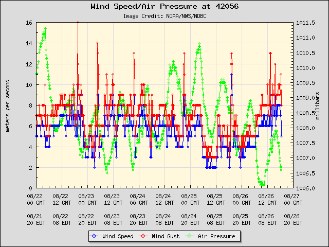
https://www.ndbc.noaa.gov/station_page. ... tion=42056
https://www.ndbc.noaa.gov/station_page. ... tion=42056
Last edited by gatorcane on Sat Aug 26, 2023 1:54 pm, edited 1 time in total.
2 likes
Re: ATL: INVEST 93L - Discussion
Sciencerocks wrote:Looks like a tropical storm with around 35knt winds.
https://imagizer.imageshack.com/img923/6966/b0DCuO.gif
Agreed. Whether it can keep over water is probably key from here. I'll be interested in what the NHC do.
1 likes
Re: ATL: INVEST 93L - Discussion
Poonwalker wrote:This could be a perfect example of the battle between El Niño and the current record Atlantic water temps. Which will win? There is certainly westerly shear to the north and also NW shear to the east. The core however is really ramping up over the warm deep water.
El Nino clearly does not create ULAC in West Caribbean.
2 likes
-
MarioProtVI
- Category 5
- Posts: 1039
- Age: 24
- Joined: Sun Sep 29, 2019 7:33 pm
- Location: New Jersey
Re: ATL: INVEST 93L - Discussion
wxman57 wrote:Satellite imagery is suggestive of at least a TD and quite possibly a TS. However, wind to its west in Cancun is NNW at only 5 kts. We have seen systems in the past that look like tropical storms on satellite, but recon can't close off a well-defined circulation. In this case, I think it's a TD and NHC will start advisories in a couple hours. As for landfall intensity, it does look like SW wind shear increases the farther north it tracks. The environment across the NE Gulf may not be favorable enough for a hurricane to survive. Lots of southwest wind shear north of 25N. Our shift forecaster wanted to go 65-70 kts at landfall, but we talked him down from the ledge until we're more confident. Always better to start low and go stronger than the other way around.
I'm thinking NHC will call it a TD and predict landfall north of Tampa just east of the big bend as a 55kt or 60kt TS on their first advisory. Could be some significant rain and wind into the Tampa area Wednesday morning. It emerges offshore S. Carolina late Wednesday and might have a shot at becoming stronger as it tracks slowly away from the coast. We'll see in a couple of hours.
Feel like I’ve seen this exact scenario before and I did not like how it turned out…
6 likes
-
gulf701
- Tropical Depression

- Posts: 65
- Age: 76
- Joined: Mon Jun 14, 2010 4:43 pm
- Location: Wewahitchka, FL
Re: ATL: INVEST 93L - Discussion
Having endured Michael, 93 has our attention. We need some rain, but zero wind.
This is what Tallahassee NWS had in its latest discussion.
.LONG TERM...
(Tuesday through Friday)
Issued at 314 AM EDT Sat Aug 26 2023
Attention turns to the south with the eventual track and evolution
of the tropical system in the western Caribbean. The break in the
ridge, along with a retrograding upper low in the northern Gulf,
should allow the system to move north rather quickly towards the
northern and northeast Gulf coast Tuesday night and Wednesday. As
of this morning, NHC gives this system a 60% chance of development
in the next 48 hours and a 90% chance of development in the next
7 days.
Since the system hasn`t `developed` yet, model solutions for the
track and intensity are fairly wide and uncertainty is high.
Once and if the system develops, this will greatly determine the
magnitude of impacts to the region. Its too early to pinpoint
specific impacts at this stage.
It is highly recommended to stay tuned to future forecasts and
latest updates. You can also check for updates at the NHC webpage at
www.hurricanes.gov along with hurricane preparedness tips at
www.noaa.gov/hurricane-prep
0 likes
Re: ATL: INVEST 93L - Discussion
AL, 93, 2023082618, , BEST, 0, 211N, 861W, 25, 1006, DB,
Doubt they are going to upgrade it at 5.
0 likes
Re: ATL: INVEST 93L - Discussion
The buoy in the channel has had strong west winds for hours
https://www.ndbc.noaa.gov/station_page. ... t=E&tz=EST
https://www.ndbc.noaa.gov/station_page. ... t=E&tz=EST
1 likes

Re: ATL: INVEST 93L - Discussion
MarioProtVI wrote:wxman57 wrote:Satellite imagery is suggestive of at least a TD and quite possibly a TS. However, wind to its west in Cancun is NNW at only 5 kts. We have seen systems in the past that look like tropical storms on satellite, but recon can't close off a well-defined circulation. In this case, I think it's a TD and NHC will start advisories in a couple hours. As for landfall intensity, it does look like SW wind shear increases the farther north it tracks. The environment across the NE Gulf may not be favorable enough for a hurricane to survive. Lots of southwest wind shear north of 25N. Our shift forecaster wanted to go 65-70 kts at landfall, but we talked him down from the ledge until we're more confident. Always better to start low and go stronger than the other way around.
I'm thinking NHC will call it a TD and predict landfall north of Tampa just east of the big bend as a 55kt or 60kt TS on their first advisory. Could be some significant rain and wind into the Tampa area Wednesday morning. It emerges offshore S. Carolina late Wednesday and might have a shot at becoming stronger as it tracks slowly away from the coast. We'll see in a couple of hours.
Feel like I’ve seen this exact scenario before and I did not like how it turned out…
The Tampa shields always work, pray for those in the big bend/panhandle.
0 likes
Re: ATL: INVEST 93L - Discussion
zzzh wrote:AL, 93, 2023082618, , BEST, 0, 211N, 861W, 25, 1006, DB,
Doubt they are going to upgrade it at 5.
If it's close enough, I think they will. We're inside of a 120 hour window and closer to 96. Need to get the word out.
0 likes

Re: ATL: INVEST 93L - Discussion
zzzh wrote:AL, 93, 2023082618, , BEST, 0, 211N, 861W, 25, 1006, DB,
Doubt they are going to upgrade it at 5.
At the very least we should get a PTC. The 2pm TWO said that advisories will be initiated later today if development trends continue.
0 likes
Irene '11 Sandy '12 Hermine '16 5/15/2018 Derecho Fay '20 Isaias '20 Elsa '21 Henri '21 Ida '21
I am only a meteorology enthusiast who knows a decent amount about tropical cyclones. Look to the professional mets, the NHC, or your local weather office for the best information.
I am only a meteorology enthusiast who knows a decent amount about tropical cyclones. Look to the professional mets, the NHC, or your local weather office for the best information.
-
Hurricane2022
- Category 5
- Posts: 2093
- Joined: Tue Aug 23, 2022 11:38 pm
- Location: Araçatuba, Brazil
Re: ATL: INVEST 93L - Discussion
wxman57 wrote:I'm thinking NHC will call it a TD and predict landfall north of Tampa just east of the big bend as a 55kt or 60kt TS on their first advisory. Could be some significant rain and wind into the Tampa area Wednesday morning. It emerges offshore S. Carolina late Wednesday and might have a shot at becoming stronger as it tracks slowly away from the coast. We'll see in a couple of hours.
8 likes
Sorry for the bad English sometimes...!
For reliable and detailed information for any meteorological phenomenon, please consult the National Hurricane Center, Joint Typhoon Warning Center , or your local Meteo Center.
--------
ECCE OMNIA NOVA FACIAM (Ap 21,5).
For reliable and detailed information for any meteorological phenomenon, please consult the National Hurricane Center, Joint Typhoon Warning Center , or your local Meteo Center.
--------
ECCE OMNIA NOVA FACIAM (Ap 21,5).
Re: ATL: INVEST 93L - Discussion
Hurricane2022 wrote:wxman57 wrote:I'm thinking NHC will call it a TD and predict landfall north of Tampa just east of the big bend as a 55kt or 60kt TS on their first advisory. Could be some significant rain and wind into the Tampa area Wednesday morning. It emerges offshore S. Carolina late Wednesday and might have a shot at becoming stronger as it tracks slowly away from the coast. We'll see in a couple of hours.
https://imageshack.com/i/poeSGmCUj
1 likes
-
johngaltfla

- Category 5
- Posts: 2073
- Joined: Sun Jul 10, 2005 9:17 pm
- Location: Sarasota County, FL
- Contact:
Re: ATL: INVEST 93L - Discussion: 2 PM TWO: Advisories later today if trend continues
xironman wrote:Wow, just happened to look up the latest on it and the model runs. This one could sneak up on people that aren't expecting such a storm in the short term.
Not our first rodeo for this happening in SW Florida. But it gets tiring. Can we just retire the letter "i" now?
0 likes
-
johngaltfla
- Category 5
- Posts: 2073
- Joined: Sun Jul 10, 2005 9:17 pm
- Location: Sarasota County, FL
- Contact:
Re: ATL: INVEST 93L - Discussion: 2 PM TWO: Advisories later today if trend continues
MGC wrote:Perfect upper level conditions above 93L currently. There is nothing to hold it back as long as the disturbance remains offshore. Wish we had recon this afternoon......MGC

3 likes
-
wxman57
- Moderator-Pro Met
- Posts: 23175
- Age: 68
- Joined: Sat Jun 21, 2003 8:06 pm
- Location: Houston, TX (southwest)
Re: ATL: INVEST 93L - Discussion
xironman wrote:The buoy in the channel has had strong west winds for hours
https://www.ndbc.noaa.gov/station_page. ... t=E&tz=EST
The southern band of squalls was passing earlier. It's outside the squalls now, but a SW wind is consistent with TD status. NHC may want to get recon in it before calling it a TD or TS. Anyone know when recon is scheduled?
0 likes
Who is online
Users browsing this forum: No registered users and 36 guests