ATL: IDALIA - Post-Tropical - Discussion
Moderator: S2k Moderators
-
gatorcane

- S2K Supporter

- Posts: 23708
- Age: 48
- Joined: Sun Mar 13, 2005 3:54 pm
- Location: Boca Raton, FL
Re: ATL: TEN - Tropical Depression - Discussion
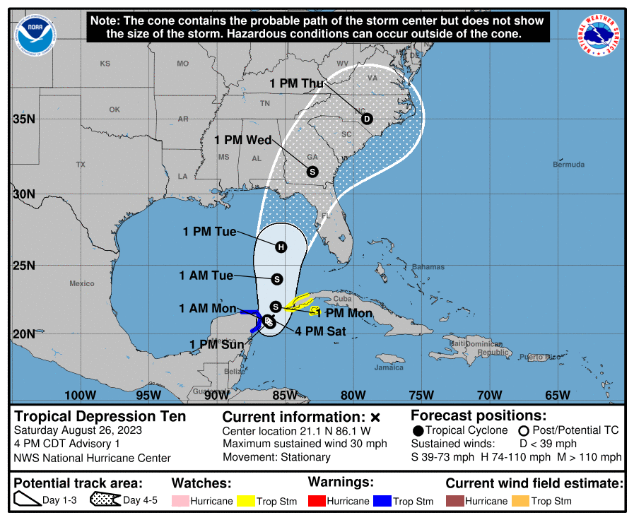
First track. From around Bradenton to Destin:
Last edited by gatorcane on Sat Aug 26, 2023 3:59 pm, edited 1 time in total.
1 likes
-
tolakram
- Admin

- Posts: 20186
- Age: 62
- Joined: Sun Aug 27, 2006 8:23 pm
- Location: Florence, KY (name is Mark)
Re: ATL: TEN - Tropical Depression - Discussion
saved loop

2 likes
M a r k
- - - - -
Join us in chat: Storm2K Chatroom Invite. Android and IOS apps also available.
The posts in this forum are NOT official forecasts and should not be used as such. Posts are NOT endorsed by any professional institution or STORM2K.org. For official information and forecasts, please refer to NHC and NWS products.
Re: ATL: TEN - Tropical Depression - Discussion

Pressure near 1005.0mb on a buoy that is ~100miles from TD10.
1 likes
-
SconnieCane
- Category 5

- Posts: 1013
- Joined: Thu Aug 02, 2018 5:29 pm
- Location: Madison, WI
Re: ATL: TEN - Tropical Depression - Discussion
ConvergenceZone wrote:Iceresistance wrote:Tropical Storm Warning for the Yucatán, and a TS Watch for Western Cuba.
Expected to peak at 65 knots in the next 3 days per Forecast Advisory
Got to give wxman credit. He nailed it saying that the NHC would go with 65 knots at landfall. High end tropical storms seems likely, but I won't be shocked if it makes it to Cat 1 in spite of the shear expected.
They go with 65 kts at the 72-hour forecast point, which is at about the latitude of Fort Myers. Plenty of water between there and landfall.
3 likes
-
Sciencerocks
- Category 5
- Posts: 10193
- Age: 40
- Joined: Thu Jul 06, 2017 1:51 am
-
SunnyThoughts
- Category 5
- Posts: 2263
- Joined: Wed Jul 09, 2003 12:42 pm
- Location: Pensacola, Florida
Re: ATL: TEN - Tropical Depression - Discussion
Looks like maybe a large "gyre" type system shaping up.
1 likes

Re: ATL: TEN - Tropical Depression - Discussion
can't go wrong with the NHC, they're the best at this stuff!
0 likes
-
FLpanhandle91

- Category 5
- Posts: 1039
- Age: 35
- Joined: Mon Sep 13, 2010 3:50 pm
- Location: Fort Walton Beach, FL
Re: ATL: TEN - Tropical Depression - Discussion
Here is a great article discussing Michael's interaction with a ULL to it's west as it moved through the Gulf and why it rapidly intensified. The big kicker seems to storm-relative shear vector and warm vs. cold air advection ahead of the storm.
https://doi.org/10.1016/j.tcrr.2019.07.009
Can any mets here describe the presumptive shear vector Idalia will interact with vs. Michael and if dry air/cold air advection will affect it on approach?
https://doi.org/10.1016/j.tcrr.2019.07.009
Can any mets here describe the presumptive shear vector Idalia will interact with vs. Michael and if dry air/cold air advection will affect it on approach?
4 likes

Re: ATL: TEN - Tropical Depression - Discussion
Salute!
Hope that probability track is too far west, Gator, and hoping the thing orbits down near Yucatan long enuf for the cold front we have coming down here to help.
Hard to predict very well by anybody once the storms get into the Gulf. I have seen some follow the black line put out by NHC, and then have seen some do a harsh turn or even to a circle.
Anyway, land fall in the big bend between St Marks and Perry has least potential for loss of life and actual high $$$ damage. It's one reason it is not well-developed.
Gums sends...
2 likes
-
TomballEd
- Category 5
- Posts: 1322
- Age: 62
- Joined: Wed Aug 16, 2023 4:52 pm
- Location: Spring/Klein area, not Tomball
Re: ATL: TEN - Tropical Depression - Discussion
I don't think anything that looks like an eye to me. NHC forecast of minimal Cat 1 about 12 hours before landfall, assuming it is correct (and they are the professionals) and no reason looking at GFS forecast antiyclone aloft to think it wouldn't still be strengthening.
0Z models should have better data to work off of, as far as intensity and track. This is a focus on the cone situation.
0Z models should have better data to work off of, as far as intensity and track. This is a focus on the cone situation.
1 likes
-
ConvergenceZone
.gif)
- Category 5
- Posts: 5241
- Joined: Fri Jul 29, 2005 1:40 am
- Location: Northern California
Re: ATL: TEN - Tropical Depression - Discussion
SconnieCane wrote:ConvergenceZone wrote:Iceresistance wrote:Tropical Storm Warning for the Yucatán, and a TS Watch for Western Cuba.
Expected to peak at 65 knots in the next 3 days per Forecast Advisory
Got to give wxman credit. He nailed it saying that the NHC would go with 65 knots at landfall. High end tropical storms seems likely, but I won't be shocked if it makes it to Cat 1 in spite of the shear expected.
They go with 65 kts at the 72-hour forecast point, which is at about the latitude of Fort Myers. Plenty of water between there and landfall.
Now that I re-read it, I think they are calling for 65 knots at PEAK though, so I'm assuming that means that they expect shear much more after that. If they aren't calling for 65 knots at peak, feel free to correct me. But then again I guess there isn't much difference between a 65 MPH or a 75 mph at landfall.
0 likes
-
skillz305
- Category 1

- Posts: 312
- Joined: Sat Sep 08, 2018 11:10 am
- Location: Miami, Florida --> Vero Beach, Florida
Re: ATL: TEN - Tropical Depression - Discussion
Trending back East, boys. Windshield wiper in full effect.
0 likes
 Hurricanes: Andrew 1992 - Irene 1999 - Frances 2004 - Jeanne 2004 - Katrina 2005 - Wilma 2005 - Matthew 2016 - Irma 2017 - Ian 2022 - Nicole 2022 - Milton 2024
Re: ATL: TEN - Tropical Depression - Discussion
I am betting some hot towers will fire up around sunset
0 likes
-
SconnieCane
- Category 5
- Posts: 1013
- Joined: Thu Aug 02, 2018 5:29 pm
- Location: Madison, WI
Re: ATL: TEN - Tropical Depression - Discussion
ConvergenceZone wrote:SconnieCane wrote:ConvergenceZone wrote:
Got to give wxman credit. He nailed it saying that the NHC would go with 65 knots at landfall. High end tropical storms seems likely, but I won't be shocked if it makes it to Cat 1 in spite of the shear expected.
They go with 65 kts at the 72-hour forecast point, which is at about the latitude of Fort Myers. Plenty of water between there and landfall.
Now that I re-read it, I think they are calling for 65 knots at PEAK though, so I'm assuming that means that they expect shear much more after that. If they aren't calling for 65 knots at peak, feel free to correct me. But then again I guess there isn't much difference between a 65 MPH or a 75 mph at landfall.
All they say about intensity is this, which is prudent at this juncture, IMO:
The tropical cyclone will be moving over very warm waters with only
moderate vertical wind shear anticipated during the next several
days. Therefore, gradual strengthening is forecast. The official
forecast is similar to the latest LGEM guidance and shows the
system becoming a hurricane over the eastern Gulf of Mexico. Users
are reminded that there is significant uncertainty in 3-4 day
intensity predictions and are urged to monitor changes to future
forecasts.
1 likes
-
ElectricStorm

- Category 5
- Posts: 5157
- Age: 25
- Joined: Tue Aug 13, 2019 11:23 pm
- Location: Norman, OK
Re: ATL: TEN - Tropical Depression - Discussion
ConvergenceZone wrote:SconnieCane wrote:ConvergenceZone wrote:
Got to give wxman credit. He nailed it saying that the NHC would go with 65 knots at landfall. High end tropical storms seems likely, but I won't be shocked if it makes it to Cat 1 in spite of the shear expected.
They go with 65 kts at the 72-hour forecast point, which is at about the latitude of Fort Myers. Plenty of water between there and landfall.
Now that I re-read it, I think they are calling for 65 knots at PEAK though, so I'm assuming that means that they expect shear much more after that. If they aren't calling for 65 knots at peak, feel free to correct me. But then again I guess there isn't much difference between a 65 MPH or a 75 mph at landfall.
They don't mention increasing shear after that
The tropical cyclone will be moving over very warm waters with only
moderate vertical wind shear anticipated during the next several
days. Therefore, gradual strengthening is forecast. The official
forecast is similar to the latest LGEM guidance and shows the
system becoming a hurricane over the eastern Gulf of Mexico. Users
are reminded that there is significant uncertainty in 3-4 day
intensity predictions and are urged to monitor changes to future
forecasts.
We'll see what the hurricane models have for the 18z runs but the last cycle all showed it strengthening all the way up to landfall. Considering how much space is between the 65kt point and land I would imagine it would probably get a little stronger than that.
That being said it's still a bit far out to know what exactly will happen. The first step is avoiding any land interaction with the Yucatan or Cuba like the current NHC track has. If it can do that I think it opens the door for a stronger system later in the gulf.
2 likes
B.S Meteorology, University of Oklahoma '25
Please refer to the NHC, NWS, or SPC for official information.
Please refer to the NHC, NWS, or SPC for official information.
Re: ATL: TEN - Tropical Depression - Discussion
skillz305 wrote:Trending back East, boys. Windshield wiper in full effect.
Yea, ICON went from Citrus county on 12z run to Bradenton landfall 18z.
0 likes
-
HurricaneBelle

- S2K Supporter
- Posts: 1209
- Joined: Sun Aug 27, 2006 6:12 pm
- Location: Clearwater, FL
Re: ATL: TEN - Tropical Depression - Discussion
Now that I re-read it, I think they are calling for 65 knots at PEAK though, so I'm assuming that means that they expect shear much more after that. If they aren't calling for 65 knots at peak, feel free to correct me. But then again I guess there isn't much difference between a 65 MPH or a 75 mph at landfall.
They're calling for a 75MPH storm at the forecast point in 4 days off of SW Florida, and the next position in the forecast isn't until 24 hours later, inland in the Big Bend area. This isn't necessarily the peak because it could strengthen between 26.3N and 31.5N in those 24 hours before making landfall.
4 likes
-
TomballEd
- Category 5
- Posts: 1322
- Age: 62
- Joined: Wed Aug 16, 2023 4:52 pm
- Location: Spring/Klein area, not Tomball
Re: ATL: TEN - Tropical Depression - Discussion
They don't publicly predict peak, unless I am very wrong. Ballpark half day before landfall at minimal Cat1 and strengthening from the Tuesday morning forecast tells me they are expecting something stronger, my unofficial guess they are thinking 75 knots at landfall. Likely center location should help 0Z forecasts, and a plethora of upper level and low level recon data, tomorrow's 0Z models should clarify far more. Landfall location could be Tampa Bay to Mobile, IMHO, and I suspect the landfall strength may be a bit higher than Cat 1. HAFS models unlikely, but give an upper range.
1 likes
-
Blown Away

- S2K Supporter
- Posts: 10253
- Joined: Wed May 26, 2004 6:17 am
Re: ATL: TEN - Tropical Depression - Discussion
gatorcane wrote:First track. From around Bradenton to Destin:
https://i.postimg.cc/HshVDykY/205449-5day-cone-no-line-and-wind.png
That’s a very rare hurricane track into the Big Bend arm pit. Just like with Ian, I’ll play the big odds that doesn’t happen. JMHO
2 likes
Hurricane Eye Experience: David 79, Irene 99, Frances 04, Jeanne 04, Wilma 05… Hurricane Brush Experience: Andrew 92, Erin 95, Floyd 99, Matthew 16, Irma 17, Ian 22, Nicole 22…
-
REDHurricane

- Category 1
- Posts: 438
- Age: 28
- Joined: Sun Jul 03, 2022 2:36 pm
- Location: Northeast Pacific Ocean
Re: ATL: TEN - Tropical Depression - Discussion
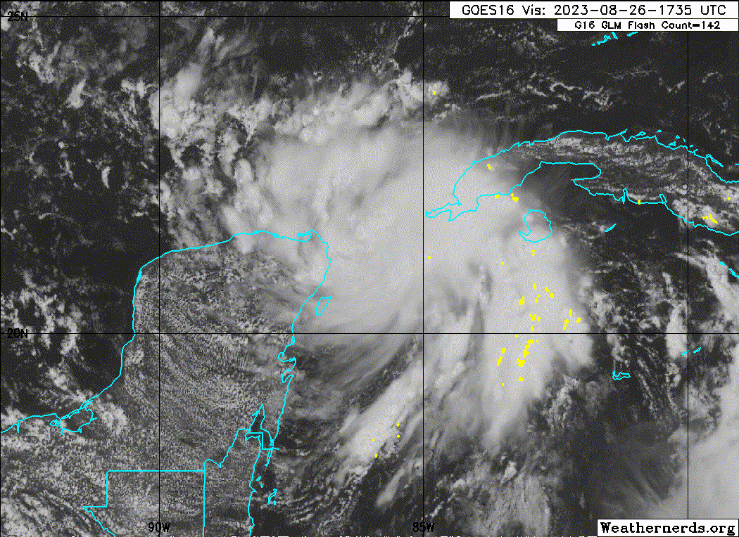
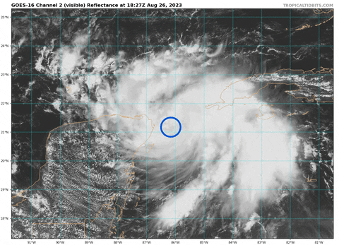
Center appears to be trying to consolidate just slightly northeast of the current NHC best track location of 21.1ºN, 86.1ºW
7 likes
Who is online
Users browsing this forum: No registered users and 34 guests