


ATL: IDALIA - Models
Moderator: S2k Moderators
-
TomballEd
- Category 5

- Posts: 1264
- Age: 62
- Joined: Wed Aug 16, 2023 4:52 pm
- Location: Spring/Klein area, not Tomball
Re: ATL: INVEST 93L - Models
0 likes
-
tolakram
- Admin

- Posts: 20179
- Age: 62
- Joined: Sun Aug 27, 2006 8:23 pm
- Location: Florence, KY (name is Mark)
Re: ATL: INVEST 93L - Models
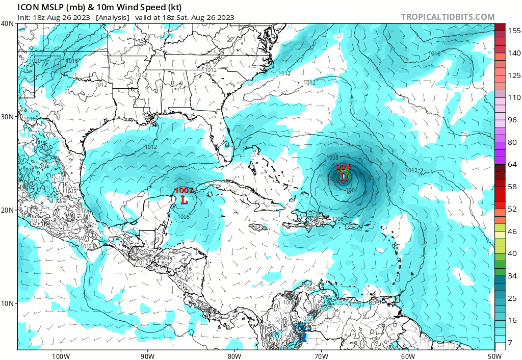
Possibly TD10, NHC actually has control over the automated designations and can change them up until advisories post.
0 likes
M a r k
- - - - -
Join us in chat: Storm2K Chatroom Invite. Android and IOS apps also available.
The posts in this forum are NOT official forecasts and should not be used as such. Posts are NOT endorsed by any professional institution or STORM2K.org. For official information and forecasts, please refer to NHC and NWS products.

Re: ATL: INVEST 93L - Models
MetroMike wrote:This just dropped
https://i.imgur.com/S7EK0hC.png
Definitely shows a decent hit coming for the Gulf Coast. Higher resolution models and mesoscales ought to start telegraphing structure. Those rain channels can set up on the east side so even if it’s a NE Gulf hit, you know some people on the peninsula are going to see extreme rainfall.
1 likes
-
gatorcane

- S2K Supporter

- Posts: 23708
- Age: 48
- Joined: Sun Mar 13, 2005 3:54 pm
- Location: Boca Raton, FL
Re: ATL: TEN - Models
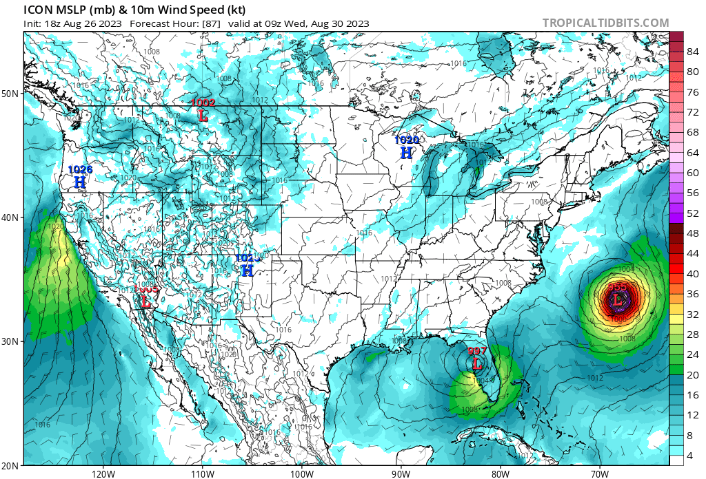
18Z ICON has shifted east some through 57 hours so far. Perhaps the west shifts are over:
1 likes
-
ScottNAtlanta

- Category 5
- Posts: 2535
- Joined: Sat May 25, 2013 3:11 pm
- Location: Atlanta, GA
Re: ATL: TEN - Models
Almost all of the hurricane models are now making this a strong hurricane at landfall both the HAFS-A and HAFS-B both make this a sub 950mb storm at landfall
0 likes
The posts in this forum are NOT official forecast and should not be used as such. They are just the opinion of the poster and may or may not be backed by sound meteorological data. They are NOT endorsed by any professional institution or storm2k.org. For official information, please refer to the NHC and NWS products.
-
Stormlover1970
- Tropical Low

- Posts: 32
- Age: 56
- Joined: Sun May 22, 2022 9:26 am
- Location: New Port Richey, Florida
Re: ATL: TEN - Models
The nhc does not.ScottNAtlanta wrote:Almost all of the hurricane models are now making this a strong hurricane at landfall both the HAFS-A and HAFS-B both make this a sub 950mb storm at landfall
1 likes
-
skillz305
- Category 1

- Posts: 312
- Joined: Sat Sep 08, 2018 11:10 am
- Location: Miami, Florida --> Vero Beach, Florida
Re: ATL: TEN - Models
18z ICON way East. Landfall in TB. Lil worries for SWFL (I’m on EC CFL)
Last edited by skillz305 on Sat Aug 26, 2023 4:17 pm, edited 1 time in total.
1 likes
 Hurricanes: Andrew 1992 - Irene 1999 - Frances 2004 - Jeanne 2004 - Katrina 2005 - Wilma 2005 - Matthew 2016 - Irma 2017 - Ian 2022 - Nicole 2022 - Milton 2024
-
ScottNAtlanta
- Category 5
- Posts: 2535
- Joined: Sat May 25, 2013 3:11 pm
- Location: Atlanta, GA
Re: ATL: TEN - Models
Stormlover1970 wrote:The nhc does not.ScottNAtlanta wrote:Almost all of the hurricane models are now making this a strong hurricane at landfall both the HAFS-A and HAFS-B both make this a sub 950mb storm at landfall
This is the models thread...not the NHC forecast thread

3 likes
The posts in this forum are NOT official forecast and should not be used as such. They are just the opinion of the poster and may or may not be backed by sound meteorological data. They are NOT endorsed by any professional institution or storm2k.org. For official information, please refer to the NHC and NWS products.
-
gatorcane
- S2K Supporter
- Posts: 23708
- Age: 48
- Joined: Sun Mar 13, 2005 3:54 pm
- Location: Boca Raton, FL
Re: ATL: TEN - Models
skillz305 wrote:18z ICON way East. Landfall in TB. Lil worries for SWFL (I’m on EC CFL)
18Z ICON loop:
1 likes
-
tolakram
- Admin
- Posts: 20179
- Age: 62
- Joined: Sun Aug 27, 2006 8:23 pm
- Location: Florence, KY (name is Mark)
Re: ATL: TEN - Models
ICON landfall

2 likes
M a r k
- - - - -
Join us in chat: Storm2K Chatroom Invite. Android and IOS apps also available.
The posts in this forum are NOT official forecasts and should not be used as such. Posts are NOT endorsed by any professional institution or STORM2K.org. For official information and forecasts, please refer to NHC and NWS products.
- - - - -
Join us in chat: Storm2K Chatroom Invite. Android and IOS apps also available.
The posts in this forum are NOT official forecasts and should not be used as such. Posts are NOT endorsed by any professional institution or STORM2K.org. For official information and forecasts, please refer to NHC and NWS products.
-
skillz305
- Category 1
- Posts: 312
- Joined: Sat Sep 08, 2018 11:10 am
- Location: Miami, Florida --> Vero Beach, Florida
Re: ATL: TEN - Models
18z ICON landfall
1 likes
Hurricanes: Andrew 1992 - Irene 1999 - Frances 2004 - Jeanne 2004 - Katrina 2005 - Wilma 2005 - Matthew 2016 - Irma 2017 - Ian 2022 - Nicole 2022 - Milton 2024Re: ATL: TEN - Models
ICON model landfall around Bradenton. Landfall 12z was Citrus County so a sizeable shift back south!
0 likes
Re: ATL: TEN - Models
Ianswfl wrote:ICON model landfall around Bradenton. Landfall 12z was Citrus County so a sizeable shift back south!
That landfall is in Pinellas and Tampa Bay. Not Bradenton
0 likes
Re: ATL: TEN - Models
caneman wrote:Ianswfl wrote:ICON model landfall around Bradenton. Landfall 12z was Citrus County so a sizeable shift back south!
That landfall is in Pinellas and Tampa Bay. Not Bradenton
Yep, looks like St Pete to me
1 likes
Re: ATL: TEN - Models
caneman wrote:Ianswfl wrote:ICON model landfall around Bradenton. Landfall 12z was Citrus County so a sizeable shift back south!
That landfall is in Pinellas and Tampa Bay. Not Bradenton
hard to tell on the models splitting hairs by a few miles, Bradenton is on Tampa Bay anyway.
1 likes
-
gatorcane
- S2K Supporter
- Posts: 23708
- Age: 48
- Joined: Sun Mar 13, 2005 3:54 pm
- Location: Boca Raton, FL
Re: ATL: TEN - Models
18Z ICON track through FL peninsula and strengthening up until landfall and then again over the Atlantic:
Last edited by gatorcane on Sat Aug 26, 2023 4:38 pm, edited 1 time in total.
1 likes
-
tolakram
- Admin
- Posts: 20179
- Age: 62
- Joined: Sun Aug 27, 2006 8:23 pm
- Location: Florence, KY (name is Mark)
Re: ATL: TEN - Models
Happy hour has started, Hrmph on the init. This is the perfect time for the GFS to go haywire, a day before recon data gets into the model.


1 likes
M a r k
- - - - -
Join us in chat: Storm2K Chatroom Invite. Android and IOS apps also available.
The posts in this forum are NOT official forecasts and should not be used as such. Posts are NOT endorsed by any professional institution or STORM2K.org. For official information and forecasts, please refer to NHC and NWS products.
- - - - -
Join us in chat: Storm2K Chatroom Invite. Android and IOS apps also available.
The posts in this forum are NOT official forecasts and should not be used as such. Posts are NOT endorsed by any professional institution or STORM2K.org. For official information and forecasts, please refer to NHC and NWS products.
-
tolakram
- Admin
- Posts: 20179
- Age: 62
- Joined: Sun Aug 27, 2006 8:23 pm
- Location: Florence, KY (name is Mark)
Re: ATL: TEN - Models
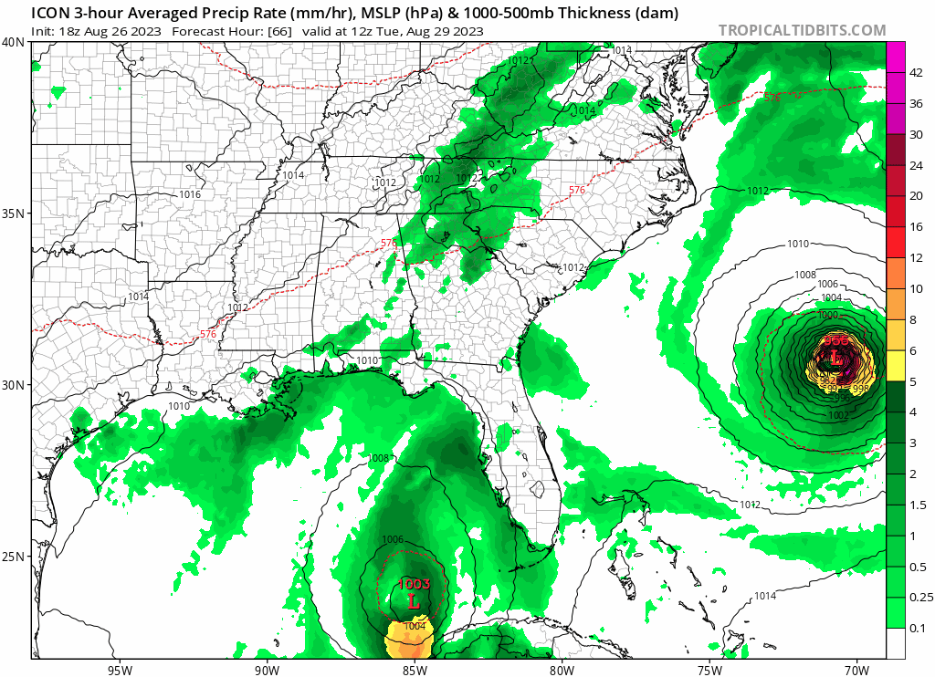
Doing the expected counter clockwise loop

0 likes
M a r k
- - - - -
Join us in chat: Storm2K Chatroom Invite. Android and IOS apps also available.
The posts in this forum are NOT official forecasts and should not be used as such. Posts are NOT endorsed by any professional institution or STORM2K.org. For official information and forecasts, please refer to NHC and NWS products.
- - - - -
Join us in chat: Storm2K Chatroom Invite. Android and IOS apps also available.
The posts in this forum are NOT official forecasts and should not be used as such. Posts are NOT endorsed by any professional institution or STORM2K.org. For official information and forecasts, please refer to NHC and NWS products.
-
tolakram
- Admin
- Posts: 20179
- Age: 62
- Joined: Sun Aug 27, 2006 8:23 pm
- Location: Florence, KY (name is Mark)
Re: ATL: TEN - Models

0 likes
M a r k
- - - - -
Join us in chat: Storm2K Chatroom Invite. Android and IOS apps also available.
The posts in this forum are NOT official forecasts and should not be used as such. Posts are NOT endorsed by any professional institution or STORM2K.org. For official information and forecasts, please refer to NHC and NWS products.
- - - - -
Join us in chat: Storm2K Chatroom Invite. Android and IOS apps also available.
The posts in this forum are NOT official forecasts and should not be used as such. Posts are NOT endorsed by any professional institution or STORM2K.org. For official information and forecasts, please refer to NHC and NWS products.
Who is online
Users browsing this forum: No registered users and 76 guests