The motion is @NNE once TD10 makes the turn N. How far E does TD10 go today or COC relocate before it turns will give us the angle.
ATL: IDALIA - Models
Moderator: S2k Moderators
-
Blown Away

- S2K Supporter

- Posts: 10253
- Joined: Wed May 26, 2004 6:17 am
Re: ATL: TEN - Models
The motion is @NNE once TD10 makes the turn N. How far E does TD10 go today or COC relocate before it turns will give us the angle.
0 likes
Hurricane Eye Experience: David 79, Irene 99, Frances 04, Jeanne 04, Wilma 05… Hurricane Brush Experience: Andrew 92, Erin 95, Floyd 99, Matthew 16, Irma 17, Ian 22, Nicole 22…
-
jlauderdal
- S2K Supporter
- Posts: 7240
- Joined: Wed May 19, 2004 5:46 am
- Location: NE Fort Lauderdale
- Contact:
Re: RE: Re: ATL: TEN - Models
Yep...until we see movement off the yucatan, low conidence track and intensity...cuban landmass could influence trackBlown Away wrote:
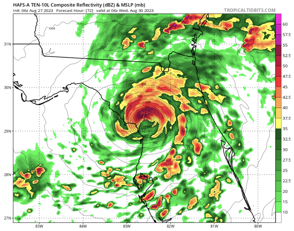
06z HAFS models >1 degree SE of 00z with landfall just N of Tampa near Crystal River. So it appears the longer TD10 takes to move out of the Caribbean that delay may result in E adjustments. Note, not as strong on the 06z compared to 00z.
0 likes
-
chris_fit

- Category 5

- Posts: 3261
- Age: 43
- Joined: Wed Sep 10, 2003 11:58 pm
- Location: Tampa Bay Area, FL
Re: ATL: TEN - Models
06z Euro is East of the 00z but nothing drastic like the shift by the hurricane models this morning.
0 likes
-
TallyTracker
- Category 2

- Posts: 787
- Joined: Thu Oct 11, 2018 2:46 pm
Re: ATL: TEN - Models
The HWRF makes that little eastern jog near the western tip of Cuba. That places the storm in a more easterly location when the NNE motion begins. That motion appears somewhat suspect. If that doesn’t happen, the storm likely landfalls further north in that model run.
0 likes
Fran '96, Georges '98, Gordon '00, Gabrielle '01, Charley '04, Frances '04, Jeanne '04, Barry '07, Fay '08, Debby '12, Matthew '16, Emily '17, Irma '17, Michael ‘18, Elsa ‘21, Fred ‘21, Mindy ‘21, Nicole ‘22, Idalia ‘23, Debby ‘24, Helene ‘24
-
gatorcane

- S2K Supporter
- Posts: 23708
- Age: 48
- Joined: Sun Mar 13, 2005 3:54 pm
- Location: Boca Raton, FL
Re: ATL: TEN - Models
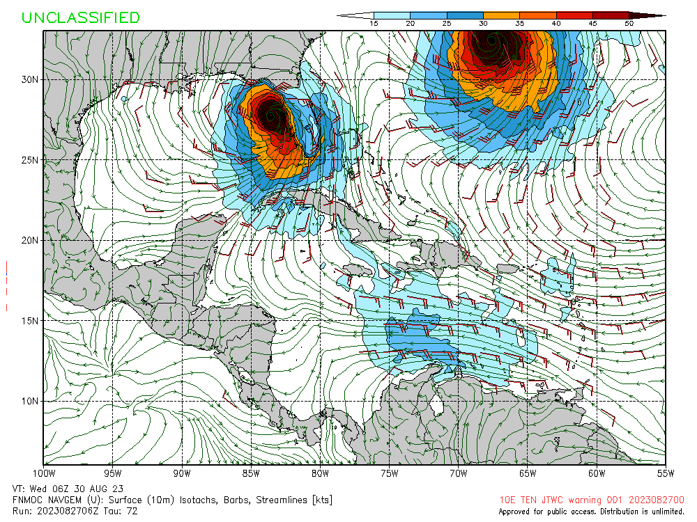
06Z NAVGEM big shift east. Was landfalling around Apalachicola on the 00Z:
1 likes

Re: ATL: TEN - Models
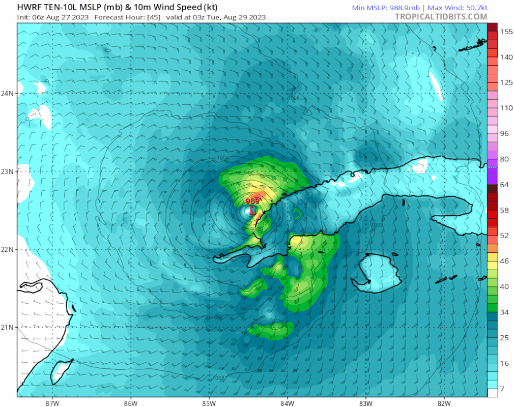
A good thing is that 6z runs of all four hurricane models have backed off from the aggressive 920s and 930s they were showing at 0z, and are now generally showing landfall pressure in the 950s and 960s. Hopefully the trend continues, although that may be wishful thinking.
Do we know if the 12z runs will have recon data, or do we have to wait for 18z? The first runs of hurricane models after recon will be crucial.
Do we know if the 12z runs will have recon data, or do we have to wait for 18z? The first runs of hurricane models after recon will be crucial.
0 likes
TC naming lists: retirements and intensity
Most aggressive Advisory #1's in North Atlantic (cr. kevin for starting the list)
Most aggressive Advisory #1's in North Atlantic (cr. kevin for starting the list)
-
cycloneye

- Admin

- Posts: 149276
- Age: 69
- Joined: Thu Oct 10, 2002 10:54 am
- Location: San Juan, Puerto Rico
Re: ATL: TEN - Models
Teban54 wrote:A good thing is that 6z runs of all four hurricane models have backed off from the aggressive 920s and 930s they were showing at 0z, and are now generally showing landfall pressure in the 950s and 960s. Hopefully the trend continues, although that may be wishful thinking.
Do we know if the 12z runs will have recon data, or do we have to wait for 18z? The first runs of hurricane models after recon will be crucial.
From the 4 AM CDT discussion.
The NOAA G-IV aircraft should be in the area this afternoon to
help smooth out the model differences along with special upper-air
soundings scheduled across many areas of the southeastern United
States.
help smooth out the model differences along with special upper-air
soundings scheduled across many areas of the southeastern United
States.
0 likes
Visit the Caribbean-Central America Weather Thread where you can find at first post web cams,radars
and observations from Caribbean basin members Click Here
and observations from Caribbean basin members Click Here
-
tolakram
- Admin
- Posts: 20179
- Age: 62
- Joined: Sun Aug 27, 2006 8:23 pm
- Location: Florence, KY (name is Mark)
Re: ATL: TEN - Models
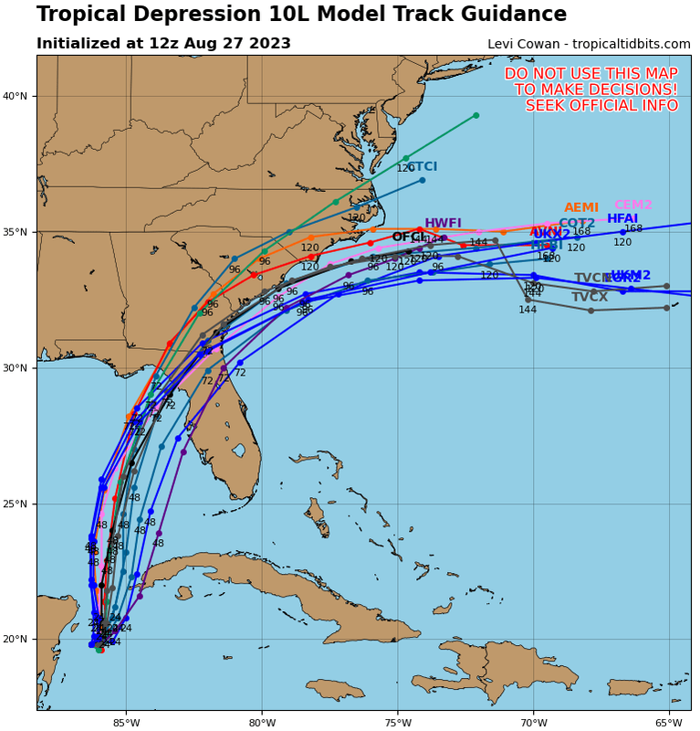
Morning model landfall predictions


4 likes
M a r k
- - - - -
Join us in chat: Storm2K Chatroom Invite. Android and IOS apps also available.
The posts in this forum are NOT official forecasts and should not be used as such. Posts are NOT endorsed by any professional institution or STORM2K.org. For official information and forecasts, please refer to NHC and NWS products.
-
chris_fit
- Category 5
- Posts: 3261
- Age: 43
- Joined: Wed Sep 10, 2003 11:58 pm
- Location: Tampa Bay Area, FL
Re: ATL: TEN - Models
gatorcane wrote:Notable east shift with 12Z guidance:
https://i.postimg.cc/7LxwvqDS/10-L-tracks-12z.png
Was not expecting that!
0 likes

Re: ATL: TEN - Models
chris_fit wrote:gatorcane wrote:Notable east shift with 12Z guidance:
https://i.postimg.cc/7LxwvqDS/10-L-tracks-12z.png
Was not expecting that!
One member even into Bradenton now. Few tampa as well.
If this is cedar Key on south quicker landfall. People will be caught off guard! Not much time for tampa to prepare. Leas than 72 hrs.
2 likes
-
SFLcane

- S2K Supporter
- Posts: 10281
- Age: 48
- Joined: Sat Jun 05, 2010 1:44 pm
- Location: Lake Worth Florida
Re: ATL: TEN - Models
Ianswfl wrote:chris_fit wrote:gatorcane wrote:Notable east shift with 12Z guidance:
https://i.postimg.cc/7LxwvqDS/10-L-tracks-12z.png
Was not expecting that!
One member even into Bradenton now. Few tampa as well.
If this is cedar Key on south quicker landfall. People will be caught off guard! Not much time for tampa to prepare. Leas than 72 hrs.
Don’t think it was the last eastward shift you’ll see.
3 likes
Re: ATL: TEN - Models
SFLcane wrote:Ianswfl wrote:chris_fit wrote:
Was not expecting that!
One member even into Bradenton now. Few tampa as well.
If this is cedar Key on south quicker landfall. People will be caught off guard! Not much time for tampa to prepare. Leas than 72 hrs.
Don’t think it was the last eastward shift you’ll see.
What's the most eastward you see the majority of the models going? Tampa region or maybe even Sarasota area?
0 likes
-
tolakram
- Admin
- Posts: 20179
- Age: 62
- Joined: Sun Aug 27, 2006 8:23 pm
- Location: Florence, KY (name is Mark)
Re: ATL: TEN - Models
6Z Euro

0 likes
M a r k
- - - - -
Join us in chat: Storm2K Chatroom Invite. Android and IOS apps also available.
The posts in this forum are NOT official forecasts and should not be used as such. Posts are NOT endorsed by any professional institution or STORM2K.org. For official information and forecasts, please refer to NHC and NWS products.
- - - - -
Join us in chat: Storm2K Chatroom Invite. Android and IOS apps also available.
The posts in this forum are NOT official forecasts and should not be used as such. Posts are NOT endorsed by any professional institution or STORM2K.org. For official information and forecasts, please refer to NHC and NWS products.
-
jlauderdal
- S2K Supporter
- Posts: 7240
- Joined: Wed May 19, 2004 5:46 am
- Location: NE Fort Lauderdale
- Contact:
Re: ATL: TEN - Models
chris_fit wrote:gatorcane wrote:Notable east shift with 12Z guidance:
https://i.postimg.cc/7LxwvqDS/10-L-tracks-12z.png
Was not expecting that!
Expect further track changes until this thing starts moving..remember the angle of approach makes big swings even more likely..a little to the right, little the left, little to the south makes the long term track very low confidence right now and the action is on the right side as usual
1 likes

Re: ATL: TEN - Models
jlauderdal wrote:chris_fit wrote:gatorcane wrote:Notable east shift with 12Z guidance:
https://i.postimg.cc/7LxwvqDS/10-L-tracks-12z.png
Was not expecting that!
Expect further track changes until this thing starts moving..remember the angle of approach makes big swings even more likely..a little to the right, little the left, little to the south makes the long term track very low confidence right now and the action is on the right side as usual
South Florida shouldn’t let their guard down either.
2 likes

Re: ATL: TEN - Models
Hurricane models 72 hrs before Michael made landfall.

Last edited by NDG on Sun Aug 27, 2023 8:51 am, edited 1 time in total.
5 likes
-
jlauderdal
- S2K Supporter
- Posts: 7240
- Joined: Wed May 19, 2004 5:46 am
- Location: NE Fort Lauderdale
- Contact:
Re: ATL: TEN - Models
boca wrote:jlauderdal wrote:chris_fit wrote:
Was not expecting that!
Expect further track changes until this thing starts moving..remember the angle of approach makes big swings even more likely..a little to the right, little the left, little to the south makes the long term track very low confidence right now and the action is on the right side as usual
South Florida shouldn’t let their guard down either.
Correct, we have to see how intense it gets and of course track....its all about the feeder bands and where they setup for us
0 likes
Who is online
Users browsing this forum: No registered users and 97 guests