ATL: IDALIA - Post-Tropical - Discussion
Moderator: S2k Moderators
-
Coolcruiseman
- Tropical Depression

- Posts: 97
- Age: 51
- Joined: Wed Sep 21, 2022 8:10 pm
- Location: Melbourne, FL
Re: ATL: TEN - Tropical Depression - Discussion
An interesting start to this storm. Have there been other storms that start like this before taking a beeline towards Florida?
0 likes
Re: ATL: TEN - Tropical Depression - Discussion
GCANE wrote:Very strong surface winds in the MCS's
Largest so far is 67 knts
If that takes over we could get a cat4 in the Gulf! Also means more east, even Bradenton could be in play. Luckily tue late night landfall so less time then.
1 likes
-
Frank P
- S2K Supporter

- Posts: 2779
- Joined: Fri Aug 29, 2003 10:52 am
- Location: Biloxi Beach, Ms
- Contact:
Re: ATL: TEN - Tropical Depression - Discussion
TallyTracker wrote:Frank P wrote:Using the MSFC VIS SAT LOOPS, this certainly looks like the center of TD10.
https://weather.ndc.nasa.gov/cgi-bin/post-abi
https://i.ibb.co/82jjZrw/IMG-3650.jpg
I agree that looks like the center. Not sure if it’s THE center or one of several. It appears to be moving NE at a good clip.
Yeah, I was looking at it and it definitely moving off to the NE, could be the center or one hell of a very strong eddy TD10 is spitting out. If it’s the center is was entirely exposed at one point in the loop.
0 likes
Re: ATL: TEN - Tropical Depression - Discussion
Coolcruiseman wrote:An interesting start to this storm. Have there been other storms that start like this before taking a beeline towards Florida?
Wilma comes to mind. Hung out in the W. Car for a while before it trucked to FL.
1 likes
Andrew (1992), Irene (1999), Frances (2004), Katrina (2005), Wilma (2005), Fay (2008), Irma (2017), Eta (2020), Ian (2022)

Re: ATL: TEN - Tropical Depression - Discussion
Ianswfl wrote:GCANE wrote:Very strong surface winds in the MCS's
Largest so far is 67 knts
If that takes over we could get a cat4 in the Gulf! Also means more east, even Bradenton could be in play. Luckily tue late night landfall so less time then.
Not out of the question.
Forecasted conditions in the GoM were IMHO good yesterday to very good today.
Tomorrow maybe excellent especially if the W GoM trof tilts more positive giving a better anticyclonic wave break.
Loop Current and top-end CAPE is pure nitro fuel.
0 likes

Re: ATL: TEN - Tropical Depression - Discussion
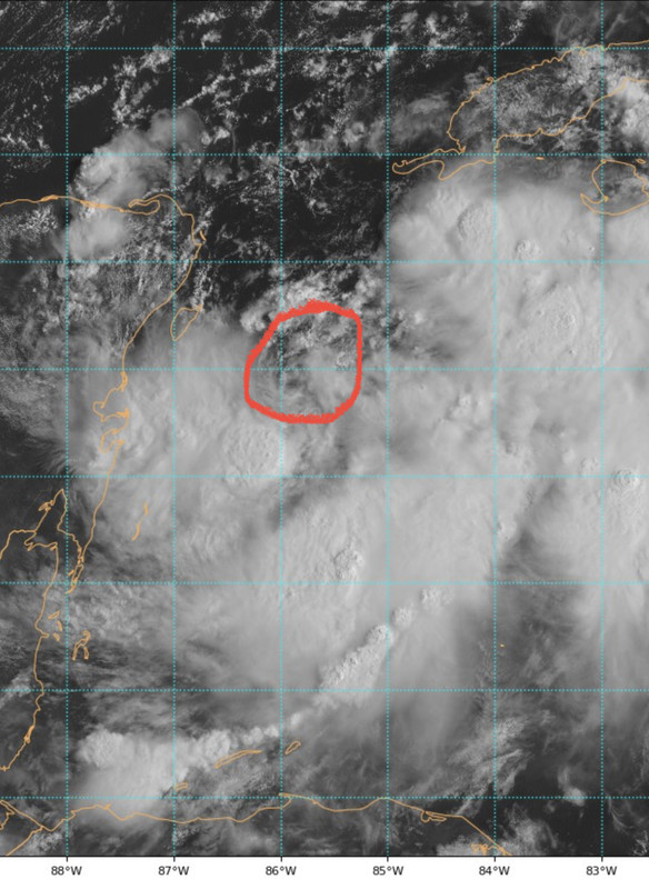
Naked swirl alert, not surprising because of the predicted northerly shear as UL anticyclone moves SW away from it.
Appears to be moving east now.

Appears to be moving east now.
Last edited by NDG on Sun Aug 27, 2023 9:20 am, edited 1 time in total.
5 likes
-
stormhunter7

- Category 2

- Posts: 763
- Joined: Mon May 26, 2008 3:13 pm
- Location: Panama City Beach, Florida
- Contact:
Re: ATL: TEN - Tropical Depression - Discussion
Clearly see a low level swirl in visible satellite now... Looks to be moving east?
2 likes
The following post is NOT an official forecast and should not be used as such. It is just the opinion of the poster and may or may not be backed by sound meteorological data. It is NOT endorsed by any professional institution including storm2k.org For Official Information please refer to the NHC and NWS products. http://www.nhc.noaa.gov

Re: ATL: TEN - Tropical Depression - Discussion
NDG wrote:Naked swirl alert, not surprising because of the predicted northerly shear as UL anticyclone moves SW away from it.
Appears to be moving east now.
https://i.imgur.com/L5Hsv0i.gif
Recon is way south of it. I hope they check it out; sometimes they miss where an LLC is forming in these invests or new TDs.
1 likes
Irene '11 Sandy '12 Hermine '16 5/15/2018 Derecho Fay '20 Isaias '20 Elsa '21 Henri '21 Ida '21
I am only a meteorology enthusiast who knows a decent amount about tropical cyclones. Look to the professional mets, the NHC, or your local weather office for the best information.
I am only a meteorology enthusiast who knows a decent amount about tropical cyclones. Look to the professional mets, the NHC, or your local weather office for the best information.
-
johngaltfla

- Category 5

- Posts: 2073
- Joined: Sun Jul 10, 2005 9:17 pm
- Location: Sarasota County, FL
- Contact:
Re: ATL: TEN - Tropical Depression - Discussion
Coolcruiseman wrote:An interesting start to this storm. Have there been other storms that start like this before taking a beeline towards Florida?
Since I moved back here in 1987 let me just sum up the scientific jargon into one word:
"Lots"
3 likes
Re: ATL: TEN - Tropical Depression - Discussion
Kind of weird first approach to the south of it, plenty of west winds, is closed 

0 likes
-
johngaltfla
- Category 5
- Posts: 2073
- Joined: Sun Jul 10, 2005 9:17 pm
- Location: Sarasota County, FL
- Contact:
Re: ATL: TEN - Tropical Depression - Discussion
NDG wrote:Naked swirl alert, not surprising because of the predicted northerly shear as UL anticyclone moves SW away from it.
Appears to be moving east now.
https://i.imgur.com/L5Hsv0i.gif
Which means the storms should start wrapping around rapidly by tonight. Not good for FL.
0 likes
-
Blown Away

- S2K Supporter
- Posts: 10253
- Joined: Wed May 26, 2004 6:17 am
Re: ATL: TEN - Tropical Depression - Discussion
From 4am Update:
INIT 27/0900Z 20.1N 86.8W 30 KT 35 MPH
12H 27/1800Z 20.1N 86.5W 40 KT 45 MPH
24H 28/0600Z 20.6N 86.3W 45 KT 50 MPH
36H 28/1800Z 21.7N 86.3W 50 KT 60 MPH
48H 29/0600Z 23.3N 86.2W 60 KT 70 MPH
60H 29/1800Z 25.7N 85.7W 75 KT 85 MPH
72H 30/0600Z 28.5N 84.7W 80 KT 90 MPH
96H 31/0600Z 33.0N 81.2W 45 KT 50 MPH...INLAND
120H 01/0600Z 35.0N 75.5W 35 KT 40 MPH...OVER WATER
If the COC is in the circle @19.9N/85.8W, the 4am didn’t have TD10 crossing 85.7 for @60 hrs…
1 likes
Hurricane Eye Experience: David 79, Irene 99, Frances 04, Jeanne 04, Wilma 05… Hurricane Brush Experience: Andrew 92, Erin 95, Floyd 99, Matthew 16, Irma 17, Ian 22, Nicole 22…
Re: ATL: TEN - Tropical Depression - Discussion
aspen wrote:NDG wrote:Naked swirl alert, not surprising because of the predicted northerly shear as UL anticyclone moves SW away from it.
Appears to be moving east now.
https://i.imgur.com/L5Hsv0i.gif
Recon is way south of it. I hope they check it out; sometimes they miss where an LLC is forming in these invests or new TDs.
I am sure they know where it is, it has been nicely tracked from the Cancun radar.
1 likes

Re: ATL: TEN - Tropical Depression - Discussion
aspen wrote:NDG wrote:Naked swirl alert, not surprising because of the predicted northerly shear as UL anticyclone moves SW away from it.
Appears to be moving east now.
https://i.imgur.com/L5Hsv0i.gif
Recon is way south of it. I hope they check it out; sometimes they miss where an LLC is forming in these invests or new TDs.
Recon is checking the southern quadrants.
center loks near 19.8n -85.8w
1 likes
Re: ATL: TEN - Tropical Depression - Discussion
Blown Away wrote:[url]https://i.postimg.cc/Gtgk2f4S/9-DB7-E8-A9-AA95-48-D7-BCC6-9-AB3250-AAC6-A.jpg [/url]From 4am Update:
INIT 27/0900Z 20.1N 86.8W 30 KT 35 MPH
12H 27/1800Z 20.1N 86.5W 40 KT 45 MPH
24H 28/0600Z 20.6N 86.3W 45 KT 50 MPH
36H 28/1800Z 21.7N 86.3W 50 KT 60 MPH
48H 29/0600Z 23.3N 86.2W 60 KT 70 MPH
60H 29/1800Z 25.7N 85.7W 75 KT 85 MPH
72H 30/0600Z 28.5N 84.7W 80 KT 90 MPH
96H 31/0600Z 33.0N 81.2W 45 KT 50 MPH...INLAND
120H 01/0600Z 35.0N 75.5W 35 KT 40 MPH...OVER WATER
If the COC is in the circle @19.9N/85.8W, the 4am didn’t have TD10 crossing 85.7 for @60 hrs…
Nit good for further down the coast. Landfall around tampa would give me hurricane gusts in Punta Gorda
0 likes
-
stormhunter7
- Category 2
- Posts: 763
- Joined: Mon May 26, 2008 3:13 pm
- Location: Panama City Beach, Florida
- Contact:
Re: ATL: TEN - Tropical Depression - Discussion
Miss Piggy is at 10kft... So I know they can see surface center. Might see something on radar they want to investigate... They have turned NNE now.
0 likes
The following post is NOT an official forecast and should not be used as such. It is just the opinion of the poster and may or may not be backed by sound meteorological data. It is NOT endorsed by any professional institution including storm2k.org For Official Information please refer to the NHC and NWS products. http://www.nhc.noaa.gov
Re: ATL: TEN - Tropical Depression - Discussion
You can nicely see how the convection has been sheared to the south of the LLC as it started tracking to the east.

1 likes
-
skillz305
- Category 1

- Posts: 312
- Joined: Sat Sep 08, 2018 11:10 am
- Location: Miami, Florida --> Vero Beach, Florida
Re: ATL: TEN - Tropical Depression - Discussion
Blown Away wrote:[url]https://i.postimg.cc/Gtgk2f4S/9-DB7-E8-A9-AA95-48-D7-BCC6-9-AB3250-AAC6-A.jpg [/url]From 4am Update:
INIT 27/0900Z 20.1N 86.8W 30 KT 35 MPH
12H 27/1800Z 20.1N 86.5W 40 KT 45 MPH
24H 28/0600Z 20.6N 86.3W 45 KT 50 MPH
36H 28/1800Z 21.7N 86.3W 50 KT 60 MPH
48H 29/0600Z 23.3N 86.2W 60 KT 70 MPH
60H 29/1800Z 25.7N 85.7W 75 KT 85 MPH
72H 30/0600Z 28.5N 84.7W 80 KT 90 MPH
96H 31/0600Z 33.0N 81.2W 45 KT 50 MPH...INLAND
120H 01/0600Z 35.0N 75.5W 35 KT 40 MPH...OVER WATER
If the COC is in the circle @19.9N/85.8W, the 4am didn’t have TD10 crossing 85.7 for @60 hrs…
Yup. Once the recon data is fed into the models I fear a big swing in the model guidances. It’s part of the game.
1 likes
 Hurricanes: Andrew 1992 - Irene 1999 - Frances 2004 - Jeanne 2004 - Katrina 2005 - Wilma 2005 - Matthew 2016 - Irma 2017 - Ian 2022 - Nicole 2022 - Milton 2024
-
gatorcane

- S2K Supporter
- Posts: 23708
- Age: 48
- Joined: Sun Mar 13, 2005 3:54 pm
- Location: Boca Raton, FL
Re: ATL: TEN - Tropical Depression - Discussion
Definitely looks like the LLC is moving east, the more east it goes the more the track could shift east.

4 likes
-
Spacecoast

- Category 2
- Posts: 773
- Joined: Thu Aug 31, 2017 2:03 pm

Who is online
Users browsing this forum: No registered users and 8 guests